Estimation of soil loss using RUSLE model and GIS tools: Case study in the Jucusbamba Micro-Watershed (Amazonas, NW Peru)
Abstract
Human activities have intensified soil erosion globally, negatively impacting the physical, chemical, and microbiological quality of water and soil. This study estimated soil loss in the Jucusbamba Micro-Watershed (Amazonas, northwestern Peru) using the Revised Universal Soil Loss Equation (RUSLE) integrated with Geographic Information Systems (GIS) and remote sensing (RS) data. Meteorological data, soil maps, digital elevation models, and land cover and use maps were integrated into a GIS environment to predict the spatial distribution of erosion. The results showed five classes of soil loss severity: slight (93.34%), moderate (3.94%), high (1.82%), very high (0.61%), and severe (0.29%). Areas with high, very high, and severe erosion levels were mainly located in the middle and lower parts of the micro-watershed. The average annual soil loss was estimated at 23.24 t/ha/year. The information obtained is crucial for the formulation of soil management plans and programs to address erosion problems in the Jucusbamba River Micro-Watershed. Future research should focus on validating these models through field studies and implementing soil conservation practices based on these findings.
Keywords:
Amazonas; hydrology; RUSLE model; water erosion map; watershed
Resumo
As atividades humanas intensificaram a erosão do solo globalmente, impactando negativamente a qualidade física, química e microbiológica da água e do solo. Este estudo tem como objetivo estimar a perda de solo na microbacia de Jucusbamba (Amazonas, noroeste do Peru) utilizando a Equação Universal Revisada de Perda de Solo (RUSLE) integrada com Sistemas de Informação Geográfica (SIG) e dados de sensoriamento remoto (SR). Dados meteorológicos, mapas de solos, modelos digitais de elevação e mapas de cobertura e uso do solo foram integrados em um ambiente SIG para prever a distribuição espacial da erosão. Os resultados mostraram cinco classes de severidade da perda de solo: leve (93,34%), moderada (3,94%), alta (1,82%), muito alta (0,61%) e severa (0,29%). Áreas com níveis altos, muito altos e severos de erosão do solo estavam localizadas principalmente nas partes média e baixa da microbacia. A perda média anual de solo foi estimada em 23,24 t/ha/ano. As informações obtidas são cruciais para a formulação de planos e programas de manejo de solos para abordar os problemas de erosão na microbacia do rio Jucusbamba. Pesquisas futuras devem focar na validação desses modelos por meio de estudos de campo e na implementação de práticas de conservação do solo baseadas nesses achados.
Palavras-chave:
Amazonas; bacia hidrográfica; hidrologia; mapa de erosão hídrica; modelo RUSLE
1. INTRODUCTION
Land degradation has been identified as a major issue in many developing countries (Depountis et al., 2018; Girmay et al., 2020; Kebede et al., 2021). Soil erosion, a key process of land degradation, negatively impacts ecosystem services, biodiversity, agricultural productivity, and carbon reserves (Panagos et al., 2015). The interaction between biophysical factors (soil, climate, physiography, vegetation cover, and land use) and topographic features (slope, slope length, and aspect) modulates the soil erosion process (Ganasri and Ramesh, 2016; Malleswara et al., 2005). Globally, it is estimated that water erosion transports between 23 and 42 million tons (Mt) of nitrogen (N) and between 15 and 26 Mt of phosphorus (P), adversely affecting soil nutrient availability (Pennock and Mckenzie, 2016). Major causes include deforestation, wildfires, inappropriate agricultural practices, and urban expansion, which increase soil particles' susceptibility to erosion (Gelagay and Minale, 2016; Terranova et al., 2009).
Various models have been developed to provide a clear understanding of soil erosion and its resulting impacts, as well as to predict soil loss (Benavidez et al., 2018). The choice of an appropriate erosion model for a specific study depends on watershed characteristics, their availability, and the study's objectives (Keesstra et al., 2014). These models fall into three main categories: i) Physically Based Models, which simulate interactions such as precipitation, infiltration, surface runoff, soil properties, and vegetation characteristics using principles of physics. Examples include the Water Erosion Prediction Project (WEPP) (Laflen et al., 1991), the Limburg Soil Erosion Model (LISEM) (De Roo et al., 1996), the Griffith University Erosion System Template (GUEST) (De Roo et al., 1996), and the European Soil Erosion Model (EUROSEM) (Morgan et al., 1998); ii) Empirical Models, widely used for their simplicity and lower data requirements, estimate erosion based on observed relationships derived from field measurements. Examples include the Universal Soil Loss Equation (USLE) (Wieschmeier and Smith, 1978), the Modified Universal Soil Loss Equation (MUSLE) (Williams and Berndt, 1977), the Sediment Delivery Ratio (SDR) (Young et al., 1989), the Agricultural Non-Point Source Pollution Model (AGNPS) (Young et al., 1989), and the Revised Universal Soil Loss Equation (RUSLE) (Gelagay and Minale, 2016; da Silva et al., 2007; Renard et al., 1997); and iii) Conceptual Models, which provide theoretical frameworks for understanding water and sediment dynamics on a broader scale. Examples include the Chemical Runoff and Erosion from Agricultural Management Systems (CREAMS) model (Foster et al., 1980) and the Large Scale Catchment Model (LASCAM) (Viney and Sivapalan, 1999).
Soil erosion modeling considers numerous complex interactions influencing simulated erosion rates and processes in a watershed (Devatha et al., 2015). The application of the RUSLE model as a computational tool has enhanced processing power and integration with remote sensing techniques and Geographic Information Systems (GIS), allowing for the modeling of water resource and disaster-related issues (Pham et al., 2018). Previous studies have demonstrated that geospatial technologies help determine soil erosion and its spatial distribution at reasonable costs and accuracy (Luvai et al., 2022). RUSLE has been applied in various geographic regions, including Ethiopia, Turkey, India, and the Blue Nile Basin (Elnashar et al., 2021; Getu et al., 2022; Gürtekin and Gökçe, 2021; Kayet et al., 2018). In Peru, studies have been conducted in the Chillón River (Delgado, 2020), the Angasmarca River Sub-Basin in La Libertad (Díaz, 2015), El Diablo Ravine in Tacna (Mejía-Marcacuzco et al., 2021), and the Siguas River Basin in Arequipa (Portuguez, 2015).
In the Jucusbamba River Micro-Watershed, located in the Amazonas department, Peru, soil loss due to various anthropogenic activities has been reported, resulting in significant losses in the productive capacity of soils and pastures, posing a risk to food security and the well-being of the population. Therefore, the objective of this study is to determine soil loss using the RUSLE model and GIS in the Jucusbamba Micro-Watershed. The results can serve as a source of information for decision-makers, facilitating the planning and prioritization of soil restoration projects and natural resource conservation within the micro-watershed.
2. MATERIAL AND METHODS
2.1. Study area
The Jucusbamba Micro-Watershed is located in the province of Luya, Amazonas department (Peru), between the extremes of coordinates 6°17'41.62" and 6°3'42.28" south latitude, and 77°54'51.41" and 78°4'26.52" west longitude (Figure 1). It covers an area of 19,133.13 ha and a main channel of 30.12 km. The relief is represented by mountains with very steep to steep slopes and altitudes ranging from 1,436 to 3,468 meters above sea level (Iliquin et al., 2020). The average annual temperature is 18°C with a slightly humid to warm temperate climate and precipitation in excess of 1,000 mm/year (Rodríguez Achung et al., 2010).
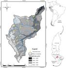
The main population centers concentrated in the micro-basin are Lámud, Luya, Trita, Luya Viejo, San Cristóbal del Olto, Cohechán, Conila and Cruz Pata, with a combined population of 10,918 inhabitants (INEI, 2017). The predominant economic activity is subsistence agriculture, livestock, and tourism. It has land suitable mainly for pasture, permanent crops, forestry, protection/conservation, and clean/intensive crops (INDES-CES, 2016).
2.2. Information acquisition
The information was collected through field trips, through direct observation of the different strata of the terrain and the collection of georeferenced data using GPS receiver equipment. Also, the global soil map developed by the Food and Agriculture Organization of the United Nations (FAO), digital elevation model of the ALOS PALSAR sensor with a spatial resolution of 12.5 meters (Shimada et al., 2014), Sentinel 2A satellite image of November 2017 provided by the Copernicus (https://www.copernicus.eu) and information from the national charts 13g and 13h of the National Geographic Institute (IGN) were downloaded. Additionally, precipitation records were acquired from the network of meteorological stations of the Universidad Nacional Toribio Rodríguez de Mendoza (UNTRM) and the National Meteorology and Hydrology Service of Perú, known as “SENAMHI” by its Spanish acronym.
2.3. Determination of soil loss due to water erosion
The implementation of the RUSLE model provides an optimal structure for analyzing soil erosion by incorporating elements such as erosive force of rainfall (R Factor), soil susceptibility to erosion (K Factor), topographic features (LS Factor), vegetation cover management (C Factor) and conservation practices (P Factor), all of which are significant in understanding soil erosion. The calculation of the RUSLE model follows Equation 1:
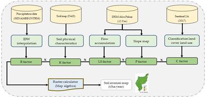
Where: A represents the average annual soil loss rate (in tons per hectare per year); R denotes the rainfall erosivity factor (in MJ.mm /h.ha/year); K indicates the soil susceptibility factor to erosion (in tons per hectare per hour per MJ.mm); LS is the factor related to topography (unitless); C represents the factor associated with vegetation cover and its management (unitless); while P refers to the factor linked to cropping practices (unitless). The estimation of the RUSLE Model was carried out using GIS techniques, as shown in Figure 2.
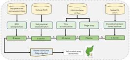
Soil loss rate was calculated following the recommendations of Fayas et al. (2019). The spatial information and all the maps of the five parameters were adjusted to the same study scale and coordinate system of WGS 1984, with a spatial resolution of 12.5 m. The layers were overlaid and multiplied by Equation 1 using the raster calculator in ArcGIS 10.5 (Gelagay and Minale, 2016).
2.3.1. Precipitation erosivity factor (R)
Erosivity caused by rainfall and runoff is described as the inherent capacity of rainfall to cause soil erosion, where the intensity, terminal velocity, droplet size, number and distribution of raindrops are determining factors that influence the total erosivity of a rainfall (Parveen and Kumar, 2012; Xu et al., 2008).
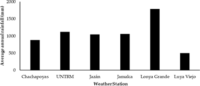
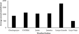
Therefore, the R factor requires continuous precipitation data (Wieschmeier and Smith, 1978). It was calculated according to Equation 2 proposed by Hurni et al. (2016) the information that was available in the study. Mean annual precipitation from 2014 to 2017 was estimated from six meteorological stations located in the Jucusbamba Micro-Watershed (Figure 3), then the data were interpolated using the Inverse Distance Weighted (IDW) method (Fayas et al., 2019; Gelagay and Minale, 2016).
Where: R is the erosivity (MJ.mm/h.ha.year) and P is the mean annual precipitation (mm).
2.3.2. Factor (K)
Soil erodibility is caused by rainwater and runoff (Thomas et al., 2018). Erodibility is influenced by a wide variety of physical, chemical, and biological properties of soil that contribute to its erodibility potential (Pham et al., 2018). The RUSLE Model considers the physical properties of structure, granulometry, permeability and organic matter as factors influencing soil erodibility (Blanco-Canqui and Lal, 2010; Phinzi and Ngetar, 2019). This factor plays an important role in soil conservation strategies (Shabani et al., 2014) and reflects the rate of soil loss due to pre-rainfall erosivity rate (Parveen and Kumar, 2012). To calculate the K-factor, Equation 3 was used (Ganasri and Ramesh, 2016).
Where: K represents soil erosion (in t.ha.h/ha.MJ. mm); m is the proportion of silt (%) plus very fine sand (%) multiplied by the complement of the percentage of clay (%); a denotes the organic matter content (%); b indicates the degree of soil structure: (1) highly structured or particulate, (2) fairly structured, (3) slightly structured, and (4) solid; and c refers to the degree of permeability of the profile: (1) rapid, (2) moderate to rapid, (3) moderate, (4) moderate to slow, (5) slow, and (6) very slow. The K-factor of a soil is determined by its texture, which includes percent silt plus very fine sand, percent sand, organic matter content, soil structure, and permeability (Wieschmeier and Smith, 1978). Data from the FAO digital soil map were transformed into a raster with a specific resolution and reassigned according to each soil type (Table 1).
Type of soil and percentages of sand, silt, clay and organic matter for the Jucusbamba Micro-Basin.
2.3.3. Factor (LS)
Topography plays an important role in soil erosion. It is given by the length (L) or accumulation of flow and slope (S) of the terrain (Datta and Schack-Kirchner, 2010). Areas with high slopes have a greater probability of erosion than flat areas (Kayet et al., 2018). The LS factor is calculated following Equation 4 (Zhang et al., 2013):
Where: LS is the slope or steepness of the slope; Q a is the flux accumulation; S g is the slope in percent; y is the dimensionless coefficient; and M is the pixel size. The value of y varies from 0.2 to 0.5 depending on the slope and the value of the slope gradient (Wieschmeier and Smith, 1978).
2.3.4. Factor (C)
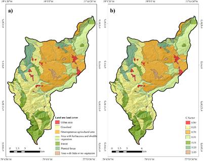
The coverage and management factor helps in the control of soil erosion and informs the management of soils by the population (Datta and Schack-Kirchner, 2010). This factor considers soil use, vegetation cover, cultivated area, soil humidity and rigor of the soil surface (Fayas et al., 2019). Likewise, it ranges between 0 and 1, where 1 indicates no vegetation cover and sterile soil, and 0 indicates presence of cover and well-protected soil (Pham et al., 2018). Subsequently, the vegetation cover and land use map were prepared (Barboza et al., 2018; Rojas et al., 2019). Table 2 was used to generate the values for each class of factor C.
Values of C factor for each class of coverage and current land use (%) for the Jucusbamba River Micro-Basin.
2.3.5. Factor (P)
The control practices factor explains the characteristics for actions that help reduce soil runoff (Kayet et al., 2018). The value of the P factor varies from 0 to 1, such that a value close to 0 indicates a good conservation practice, while a value close to 1 indicates a bad conservation practice (Correa et al., 2016). To calculate the P factor we apply the values proposed in Table 3 (Gelagay and Minale, 2016).
2.4. Calculation of soil loss
The calculation consisted of applying Equation 1. The individual factors were in raster format. The layers for each factor were overlaid and multiplied in ArcGIS 10.5. The loss values are estimated at the pixel level. They were then reclassified into five classes: namely, mild, moderate, high, very high and severe (Kayet et al., 2018).
3. RESULTS AND DISCUSSION
3.1. Rain erosion factor (R)
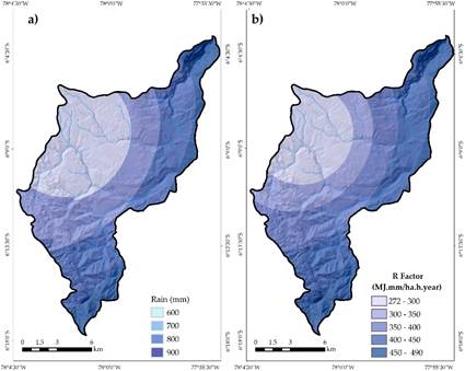
The R factor in the Jucusbamba Micro Basin ranged between 272 and 976 MJ/h.ha.year, which affects the impact of rainfall and soil runoff (Figure 4). These results were similar to those reported in the Siguas River Basin (Portuguez, 2015). The maximum values were located to the west and the minimum values to the east of the study area. Calculating the R factor is a process that involves long-term data collection (Pham et al., 2018). However, given the limited availability of sufficient data, simplified models were applied through the correlation of the R factor and the average annual precipitation (Gelagay and Minale, 2016; Hurni et al., 2016).
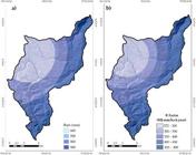
a) Average annual precipitation map in the Jucusbamba River Micro-Basin; b) Map of values of the R factor.
3.2. Soil erodibility factor (K)
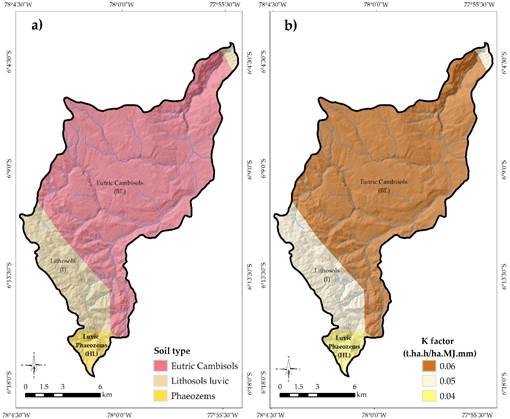
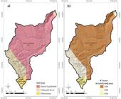
The erodibility values for Phaozem luvico, Lith-osoles and Eutric Cambisol soils were represented by 0.042, 0.057 and 0.055 t.ha.h/ha.MJ.mm, respectively (Figure 5). The low erodibility values may be related with the clay texture of the soils present in the Jucusbamba Micro-Basin with limited availability of organic matter. The values obtained are similar to those obtained in other regions such as Morocco (Aouichaty et al., 2022), Bangladesh (Saha et al., 2022) and the Diablo (Peru) (Mejía-Marcacuzco et al., 2021).
3.3. Slope factor (LS)
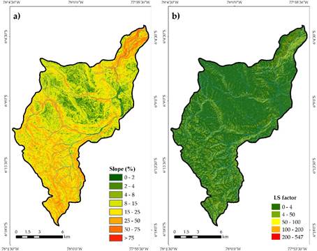
In the last two decades, there has been a significant increase in the use of GIS tools to estimate the LS factor (Zhang et al., 2017). The length of the slope (L) refers to the distance from the starting point of the surface flow to the point where the slope begins to decrease, either due to the deposition of material or due to the entry of runoff water into a well channel. Consequently, soil erosion per unit area tends to increase with the extension of the slope (Kayet et al., 2018). On the other hand, the slope slope (S) represents the effect on erosion (Thomas et al., 2018). It has been observed that the effects of slope have a more significant impact on soil loss than slope length. As the slope becomes steeper, erosion increases considerably. In the study area, the LS factor was calculated considering flow accumulation and slope in percentage as input data. The results indicate that the topographic factor varies between 0 and 547 (Figure 6). It is notable that the lowest values of the L factor prevail, while the highest values are dispersed on slopes greater than 15%, particularly near watercourses such as streams and rivers. It has been suggested that the highest levels of erosion are generally found on slopes ranging from 10% to 25% (Ganasri and Ramesh, 2016).
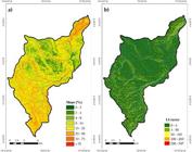
a) Map of slopes (%) for the Jucusbamba River Micro-Basin; b) Map of values of the LS factor.
3.4. Coverage and management factor (C)
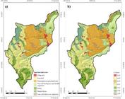
The C factor varies from 0.1 to 1 according to the coverage and land use (Figure 7). Likewise, the average C factor in the Jucusbamba River Micro-Basin was 0.34, which is classified as low (Nájera et al., 2016). It has been considered that the values of factor C have been used for crop management (Ganasri and Ramesh, 2016).
3.5. Support practice factor (P)
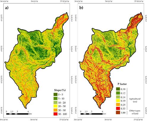
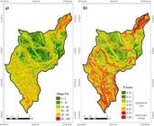
The slope map for the Jucusbamba River Micro-Basin was transformed into a vector model to assign the values of the P factor, which varied from 0.10 to 1, depending on the type of land use (agricultural land and other types of land) (Figure 8). The value greater than 1 was assigned to the other types of soil that were presented by forest and herbaceous and shrubby vegetation with slopes greater than 30%. The map also shows that along the banks of rivers and streams they have the highest values; This could be associated with the limited implementation of conservation measures, and they are more vulnerable to losing large amounts of soil unlike other areas. The lowest values are located mainly in agricultural areas. This could be related to traditional conservation practices applied by farmers (Saha et al., 2022).
3.6. Soil erosion estimation
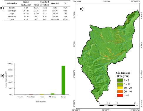
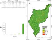
Soil erosion impacts social, economic and environmental aspects. Not only because it contributes to land degradation, but it has also contributed to economic losses and sustainable development (Covelli et al., 2020; Pennock and Mckenzie, 2016). Furthermore, affecting agricultural and forestry ecosystems (Petroselli et al., 2021). Soil erosion depends on factors such as vegetation cover and land topography (Nájera et al., 2016) that deteriorate soil properties (Salcedo-Mayta et al., 2022). Soil loss in the Jucusbamba River Micro-Basin was 23.24 t/ha.year. The classification ranges ranged from 0 to >50 t/ha/year, with an average standard deviation of 8.79 t/ha.year (Figure 9a). The largest area of the study area presents mild soil erosion (93.34%), followed by moderate (3.94%) and high (1.82%). However, soil erosion is very high and severe (represents 0.61% and 0.29%, respectively (Figure 9b).
Soil loss in the study area was spatially related to the type of vegetation cover, land use, soil type, terrain slope, altitude and precipitation. The slope, the LS factor and erodibility were the main parameters that influence soil loss. This is because the Eutric Cambisol type soils presented the highest erodibility values (0.055) in the upper and middle part of the micro basin (Gelagay and Minale, 2016). In addition, it is important to improve P and C factors to minimize the risk of soil erosion, through reforestation with broadleaf trees and legumes (Pham et al., 2018; Salcedo-Mayta et al., 2022). The soil loss map was made considering the five classes (Figure 9c). It is observed that the largest area is in the category of mild to moderate erosion, which can be found in almost all areas. Very high erosion is located in areas with steep slopes and bare soil. Likewise, moderate erosion occurs in soils where there is an agricultural area with a slight slope. Finally, the integration of GIS in the RUSLE model is feasible to investigate soil erosion in the Amazonas department.
a) Average annual precipitation map in the Jucusbamba River Micro-Basin; b) Map of values of the R factor.
4. CONCLUSIONS
The integration of the RUSLE model with GIS allowed for efficient determination of soil loss in this part of Peru. Five severity classes of soil loss were identified: slight (93.34%), moderate (3.94%), high (1.82%), very high (0.61%), and severe (0.29%) with an annual loss of sand in the micro-watershed of the Jucusbamba River was 23.24 t/ha.year. Areas with severe, very high, and high levels of soil erosion were predominantly located in the middle and lower parts of the watershed.
The study provides valuable information on soil erosion dynamics within the Jucusbamba Watershed. However, further research may be needed to validate these findings and explore additional factors influencing soil erosion in the region. This study can serve as a valuable resource for policymakers, environmental professionals, and researchers involved in soil conservation and watershed management in the Amazonian region of Peru.
5. REFERENCES
-
AOUICHATY, N.; BOUSLIHIM, Y.; HILALI, S.; ZOUHRI, A.; KOULALI, Y. Estimation of water erosion in abandoned quarries sites using the combination of RUSLE model and geostatistical method. Scientific African, v. 16, p. e01153, 2022. https://doi.org/10.1016/j.sciaf.2022.e01153
» https://doi.org/10.1016/j.sciaf.2022.e01153 -
BARBOZA, E.; SALAS, R.; MENDOZA, M.; OLIVA, S. M.; CORROTO, F. Uso actual del suelo y calidad hidrogeomorfológica del río San Antonio: alternativas para la restauración fluvial en el Norte de Perú. Revista de Investigaciones Altoandinas, v. 20, n. 2, p. 203-214, 2018. https://dx.doi.org/10.18271/ria.2018.364
» https://dx.doi.org/10.18271/ria.2018.364 -
BENAVIDEZ, R.; JACKSON, B.; MAXWELL, D.; NORTON, K. A review of the (Revised) Universal Soil Loss Equation ((R)USLE): With a view to increasing its global applicability and improving soil loss estimates. Hydrology and Earth System Sciences, v. 22, n. 11, p. 6059-6086, 2018. https://doi.org/10.5194/hess-22-6059-2018 .
» https://doi.org/10.5194/hess-22-6059-2018 -
BLANCO-CANQUI, H.; LAL, R. Principles of soil conservation and management. Springer, 2010. https://doi.org/10.1007/978-1-4020-8709-7
» https://doi.org/10.1007/978-1-4020-8709-7 -
CORREA, S. W.; MELLO, C. R.; CHOU, S. C.; CURI, N.; NORTON, L. D. Soil erosion risk associated with climate change at Mantaro River basin, Peruvian Andes. Catena, v. 147, p. 110-124, 2016. http://dx.doi.org/10.1016/j.catena.2016.07.003
» http://dx.doi.org/10.1016/j.catena.2016.07.003 -
COVELLI, C.; CIMORELLI, L.; PAGLIUCA, D. N.; MOLINO, B.; PIANESE, D. Assessment of erosion in river Basins: A distributed model to estimate the sediment production over watersheds by a 3-dimensional LS factor in RUSLE model. Hydrology, v. 7, n. 1, 2020. https://doi.org/10.3390/hydrology7010013
» https://doi.org/10.3390/hydrology7010013 -
DA SILVA, R. M.; GUIMARÃES, C. A.; PEREIRA, L.; DA COSTA, J.F. Soil loss prediction in Guaraíra river experimental basin, Paraíba, Brazil based on two erosion simulation models. Revista Ambiente & Água, v. 2, n. 3, p. 19-33, 2007. https://doi.org/10.4136/ambi-agua.30
» https://doi.org/10.4136/ambi-agua.30 -
DATTA, P. S.; SCHACK-KIRCHNER, H. Erosion relevant topographical parameters derived from different DEMs-A comparative study from the Indian lesser Himalayas. Remote Sensing, v. 2, n. 8, p. 1941-1961, 2010. https://doi.org/10.3390/rs2081941
» https://doi.org/10.3390/rs2081941 -
DE ROO, A. P. J.; WESSELING, C. G.; RITSEMA, C. J. Lisem: A single-event physically based hydrological and soil erosion model for drainage basins. I: Theory, input and output. Hydrological Processes, v. 10, n. 8, p. 1107-1117, 1996. https://doi.org/10.1002/(sici)1099-1085(199608)10:8<1107::aid-hyp415>3.0.co;2-4
» https://doi.org/10.1002/(sici)1099-1085(199608)10:8<1107::aid-hyp415>3.0.co;2-4 -
DELGADO, J. Estimación de la pérdida de suelos utilizando el modelo USLE y herramientas SIG, en la cuenca del río Chillón, Lima, Perú. South Sustainability, v. 1, p. 1-11, 2020. https://doi.org/10.21142/ss-0101-2020-007
» https://doi.org/10.21142/ss-0101-2020-007 - DEPOUNTIS, N.; VIDALI, M.; KAVOURA, K.; SABATAKAKIS, N. Soil erosion prediction at the water reservoir’s basin of pineios dam, western Greece, using the revised universal soil loss equation (RUSLE) and GIS. WSEAS Transactions on Environment and Development, v. 14, p. 457-463, 2018.
-
DEVATHA, C. P.; DESHPANDE, V.; RENUKAPRASAD, M. S. Estimation of Soil loss Using USLE Model for Kulhan Watershed, Chattisgarh- A Case Study. Aquatic Procedia, v. 4, p. 1429-1436, 2015. https://doi.org/10.1016/j.aqpro.2015.02.185
» https://doi.org/10.1016/j.aqpro.2015.02.185 -
DÍAZ, J. Diagnóstico del potencial de erosión hídrica mediante técnicas de geoprocesamiento en la sub-cuenca del río Angasmarca,La Libertad, Peru. Anales Científicos, v. 76, n. 2, p. 283, 2015. https://doi.org/10.21704/ac.v76i2.793
» https://doi.org/10.21704/ac.v76i2.793 -
ELNASHAR, A.; ZENG, H.; WU, B.; FENTA, A. A.; NABIL, M.; DUERLER, R. Soil erosion assessment in the Blue Nile Basin driven by a novel RUSLE-GEE framework. Science of the Total Environment, v. 793, p. 148466, 2021. https://doi.org/10.1016/j.scitotenv.2021.148466
» https://doi.org/10.1016/j.scitotenv.2021.148466 -
FAYAS, C. M.; ABEYSINGHA, N. S.; NIRMANEE, K. G. S.; SAMARATUNGA, D.; MALLAWATANTRI, A. Soil loss estimation using RUSLE model to prioritize erosion control in KELANI river basin in Sri Lanka. International Soil and Water Conservation Research, v. 7, n. 2, p. 130-137, 2019. http://dx.doi.org/10.1016/j.iswcr.2019.01.003
» http://dx.doi.org/10.1016/j.iswcr.2019.01.003 - FOSTER, G. R.; LANE, L. J.; NOWLIN, J. D.; LAFLEN, J. M.; YOUNG, R. A. A model to estimate sediment yield from Field-sized areas: development of model. In: KNISEL, W. G. (ed.). CREAMS: A field-scale model for Chemicals, Runoff, and Erosion from Agricultural Management Systems. Washington: US Department of Agriculture, 1980. (Conservation Research Report, 26). Cap. 3. p. 36-64.
-
GANASRI, B. P.; RAMESH, H. Assessment of soil erosion by RUSLE model using remote sensing and GIS - A case study of Nethravathi Basin. Geoscience Frontiers, v. 7, n. 6, p. 953-961, 2016. http://dx.doi.org/10.1016/j.gsf.2015.10.007
» http://dx.doi.org/10.1016/j.gsf.2015.10.007 -
GELAGAY, H. S.; MINALE, A. S. Soil loss estimation using GIS and Remote sensing techniques: A case of Koga watershed, Northwestern Ethiopia. International Soil and Water Conservation Research, v. 4, n. 2, p. 126-136, 2016. http://dx.doi.org/10.1016/j.iswcr.2016.01.002
» http://dx.doi.org/10.1016/j.iswcr.2016.01.002 -
GETU, L. A.; NAGY, A.; ADDIS, H. K. Soil loss estimation and severity mapping using the RUSLE model and GIS in Megech watershed, Ethiopia. Environmental Challenges, v. 8, n, 2022. https://doi.org/10.1016/j.envc.2022.100560
» https://doi.org/10.1016/j.envc.2022.100560 -
GIRMAY, G.; MOGES, A.; MULUNEH, A. Estimation of soil loss rate using the USLE model for Agewmariayam Watershed, northern Ethiopia. Agriculture and Food Security, v. 9, n. 1, p. 1-12, 2020. https://doi.org/10.1186/s40066-020-00262-w
» https://doi.org/10.1186/s40066-020-00262-w -
GÜRTEKIN, E.; GÖKÇE, O. Estimation of erosion risk of Harebakayiş sub-watershed, Elazig, Turkey, using GIS based RUSLE model. Environmental Challenges, v. 5, 2021. https://doi.org/10.1016/j.envc.2021.100315
» https://doi.org/10.1016/j.envc.2021.100315 - HURNI, H.; BERHE, W. A.; CHADHOKAR, P.; DANIEL, D.; GETE, Z.; GRUNDER, M. et al Soil and Water Conservation in Ethiopia: Guidlines for Development Agents. 2nd ed. Bern: CDE; BOP, 2016.
-
ILIQUIN, D.; SALAS, R.; ROJAS, N. B. Land Suitability Analysis for Potato Crop in the Jucusbamba and Tincas Micro Watersheds (Amazonas, NW Peru): AHP and RS-GIS Approach Daniel. Agronomy, v. 10, n. 1898, 2020. https://doi.org/10.3390/agronomy10121898
» https://doi.org/10.3390/agronomy10121898 - INDES-CES. Estudio semidetallado de suelos y clasificación de tierras por su capacidad de uso mayor de la microcuenca Tincas y Jucusbamba. Chachapoyas, 2016.
- INEI. Censos Nacionales de Población y Vivienda 2017. Jesús María Lima, 2017.
-
KAYET, N.; PATHAK, K.; CHAKRABARTY, A.; SAHOO, S. Evaluation of soil loss estimation using the RUSLE model and SCS-CN method in hillslope mining areas. International Soil and Water Conservation Research, v. 6, n. 1, p. 31-42, 2018. http://dx.doi.org/10.1016/j.iswcr.2017.11.002
» http://dx.doi.org/10.1016/j.iswcr.2017.11.002 -
KEBEDE, Y. S.; ENDALAMAW, N. T.; SINSHAW, B. G.; ATINKUT, H. B. Modeling soil erosion using RUSLE and GIS at watershed level in the upper beles, Ethiopia. Environmental Challenges, v. 2, 2021. https://doi.org/10.1016/j.envc.2020.100009
» https://doi.org/10.1016/j.envc.2020.100009 -
KEESSTRA, S. D.; TEMME, A. J. A. M.; SCHOORL, J. M.; VISSER, S. M. Evaluating the hydrological component of the new catchment-scale sediment delivery model LAPSUS-D. Geomorphology, v. 212, p. 97-107, 2014. https://doi.org/10.1016/j.geomorph.2013.04.021
» https://doi.org/10.1016/j.geomorph.2013.04.021 - LAFLEN, J. M.; LANE, L. J.; FOSTER, G. R. WEPP: a new generation of erosion prediction technology. Journal of Soil & Water Conservation, v. 46, n. 1, p. 34-38, 1991.
-
LUVAI, A.; OBIERO, J.; OMUTO, C. Soil Loss Assessment Using the Revised Universal Soil Loss Equation (RUSLE) Model. Applied and Environmental Soil Science, 2022. https://doi.org/10.1155/2022/2122554
» https://doi.org/10.1155/2022/2122554 -
MALLESWARA, B. N.; UMAMAHESH, N. V.; REDDY, G. T. GIS based soil erosion modelling for conservation planning of watersheds. ISH Journal of Hydraulic Engineering, v. 11, n. 3, p. 11-23, 2005. https://doi.org/10.1080/09715010.2005.10514797
» https://doi.org/10.1080/09715010.2005.10514797 - MEJÍA-MARCACUZCO, J.; PINO-VARGAS, E.; GUEVARA-PEREZ, E.; OLIVOS-ALVITES, V.; CONDORI-VENTURA, M. Spatial prediction of soil erosion in arid areas by remote sensing. A case study: Quebrada del Diablo, Tacna, Perú. Revista Ingeniería UC, v. 28, p. 252-264, 2021.
-
MORGAN, R. P. C.; QUINTON, J. N.; SMITH, R. E.; GOVERS, G.; POESEN, J. W. A. ; AUERSWALD, K. et al The European soil erosion model (EUROSEM): a dynamic approach for predicting sediment transport from fields and small catchments. Earth Surface Processes and Landforms, v. 23, n. 6, p. 527-544, 1998. https://doi.org/10.1002/(SICI)1096-9837(199806)23:6<527::AID-ESP868>3.0.CO;2-5
» https://doi.org/10.1002/(SICI)1096-9837(199806)23:6<527::AID-ESP868>3.0.CO;2-5 -
NÁJERA, O. N.; BOJÓRQUEZ, J. I.; FLORES, F.; MURRAY, R. M.; GARCÍA-SANCHO, A. G. Water erosion risk and soil loss estimation in volcanic geomorphological landscapes of Mexico. Cultivos Tropicales, v. 37, n. 2, p. 45-55, 2016. https://doi.org/10.13140/RG.2.1.3942.5527
» https://doi.org/10.13140/RG.2.1.3942.5527 - PACHECO, H.; CEVALLOS, R.; VINCES, C. Cálculo del factor C de la RUSLE, en la cuenca del río Carache, Trujillo-Venezuela usando imágenes del Satélite Miranda VRSS-1. Revista Espacios, v. 40, n. 2016, p. 6-16, 2019.
-
PANAGOS, P.; BORRELLI, P.; POESEN, J.; BALLABIO, C.; LUGATO, E.; MEUSBURGER, K. et al The new assessment of soil loss by water erosion in Europe. Environmental Science and Policy, v. 54, p. 438-447, 2015. https://doi.org/10.1016/j.envsci.2015.08.012
» https://doi.org/10.1016/j.envsci.2015.08.012 -
PARVEEN, R.; KUMAR, U. Integrated Approach of Universal Soil Loss Equation (USLE) and Geographical Information System (GIS) for Soil Loss Risk Assessment in Upper South Koel Basin, Jharkhand. Journal of Geographic Information System, v. 4, p. 588-596, 2012. https://doi.org/10.1093/nq/s4-IV.102.520-a
» https://doi.org/10.1093/nq/s4-IV.102.520-a -
PENNOCK, D.; MCKENZIE, N. Estado Mundial del Recurso Suelo: Resumen Técnico. Rome: FAO; GTIS, 2016. Available at: Available at: http://www.fao.org/3/a-i5126s.pdf Access: 2024 Aug.
» http://www.fao.org/3/a-i5126s.pdf -
PETROSELLI, A.; APOLLONIO, C.; DE LUCA, D. L.; SALVANESCHI, P.; PECCI, M.; MARRAS, T.; SCHIRONE, B. Comparative evaluation of the rainfall erosivity in the Rieti Province, central italy, using empirical formulas and a stochastic rainfall generator. Hydrology, v. 8, n. 4, 2021. https://doi.org/10.3390/hydrology8040171
» https://doi.org/10.3390/hydrology8040171 -
PHAM, T. G.; DEGENER, J.; KAPPAS, M. Integrated universal soil loss equation (USLE) and Geographical Information System (GIS) for soil erosion estimation in A Sap Basin: Central Vietnam. International Soil and Water Conservation Research, v. 6, n. 2, p. 99-110, 2018. http://dx.doi.org/10.1016/j.iswcr.2018.01.001 .
» http://dx.doi.org/10.1016/j.iswcr.2018.01.001 . -
PHINZI, K.; NGETAR, N. S. The assessment of water-borne erosion at catchment level using GIS-based RUSLE and remote sensing: A review. International Soil and Water Conservation Research, v. 7, n. 1, p. 27-46, 2019. http://dx.doi.org/10.1016/j.iswcr.2018.12.002
» http://dx.doi.org/10.1016/j.iswcr.2018.12.002 -
PORTUGUEZ, D. M. Estimación de la pérdida de suelos por erosión hídrica en la cuenca del río Siguas utilizando Geoinformatica. Anales Científicos, v. 76, n. 2, p. 324, 2015. https://doi.org/10.21704/ac.v76i2.797
» https://doi.org/10.21704/ac.v76i2.797 - RENARD, K. G.; FOSTER, G. R.; WEESIES, G. A.; MCCOOL, D. K.; YODER, D. C. Predicting soil erosion by water: a guide to conservation planning with the revised Universal Soil Loss Equation (RUSLE). U.S.: Department of Agriculture, Agriculture Handbook, 1997.
- RÖDER, J.; VILLAVICENCIO, R.; ZARAZÚA, P. Aplicación de la ecuación universal de pérdida de suelo “USLE” en SIG para estimar riesgo potencial de erosión en el área protegida “Sierra de Quila”. In: SEMANA DE LA INVESTIGACIÓN CIENTÍFICA, 17., 2006, Guadalajara. Publicaciones[…] Guadalajara: Universidad de Guadalajara, 2006. p. 156-162.
- RODRÍGUEZ ACHUNG, F. et al Zonificación Ecológica y Económica (ZEE) del departamento de Amazonas. Iquitos: GRA; IIAP, 2010.
-
ROJAS, N. B.; BARBOZA, E.; MAICELO, J. L.; OLIVA, S. M.; SALAS, R. Deforestación en la Amazonía peruana: índices de cambios de cobertura y uso del suelo basado en SIG. Boletín de la Asociación de Geógrafos Españoles, 2019. https://doi.org/10.21138/bage.2538a
» https://doi.org/10.21138/bage.2538a -
SAHA, M.; SAUDA, S. S.; REAL, H. R. K.; MAHMUD, M. Estimation of annual rate and spatial distribution of soil erosion in the Jamuna basin using RUSLE model: A geospatial approach. Environmental Challenges, v. 8, n. p. 100524, 2022. https://doi.org/10.1016/j.envc.2022.100524
» https://doi.org/10.1016/j.envc.2022.100524 -
SALCEDO-MAYTA, S.; CANIHUA-ROJAS, J.; SAMANIEGO-VIVANCO, T.; CRUZ-LUIS, J.; PÉREZ-PORRAS, W.; COSME-DELA CRUZ, R. Cover crops associated with quinoa ( Chenopodium quinoa Willd ) in the Peruvian Altiplano : Erosion reduction , improved soil health and agricultural yield. Scientia Agropecuaria Web, v. 13, n. 3, p. 265-274, 2022. https://dx.doi.org/10.17268/sci.agropecu.2022.024
» https://dx.doi.org/10.17268/sci.agropecu.2022.024 -
SHABANI, F.; KUMAR, L.; ESMAEILI, A. Improvement to the prediction of the USLE K factor. Geomorphology, v. 204, p. 229-234, 2014. http://dx.doi.org/10.1016/j.geomorph.2013.08.008
» http://dx.doi.org/10.1016/j.geomorph.2013.08.008 -
SHIMADA, M.; ITOH, T.; MOTOOKA, T.; WATANABE, M.; SHIRAISHI, T.; THAPA, R. et al Remote Sensing of Environment New global forest / non-forest maps from ALOS PALSAR data (2007 - 2010). Remote Sensing of Environment, v. 155, p. 13-31, 2014. http://dx.doi.org/10.1016/j.rse.2014.04.014
» http://dx.doi.org/10.1016/j.rse.2014.04.014 -
SINGH, G.; PANDA, R. K. Grid-cell based assessment of soil erosion potential for identification of critical erosion prone areas using USLE, GIS and remote sensing: A case study in the Kapgari watershed, India. International Soil and Water Conservation Research, v. 5, n. 3, p. 202-211, 2017. http://dx.doi.org/10.1016/j.iswcr.2017.05.006
» http://dx.doi.org/10.1016/j.iswcr.2017.05.006 -
TERRANOVA, O.; ANTRONICO, L.; COSCARELLI, R.; IAQUINTA, P. Soil erosion risk scenarios in the Mediterranean environment using RUSLE and GIS: An application model for Calabria (southern Italy). Geomorphology, v. 112, n. 3-4, p. 228-245, 2009. http://dx.doi.org/10.1016/j.geomorph.2009.06.009
» http://dx.doi.org/10.1016/j.geomorph.2009.06.009 -
THOMAS, J.; JOSEPH, S.; THRIVIKRAMJI, K. P. Assessment of soil erosion in a tropical mountain river basin of the southern Western Ghats, India using RUSLE and GIS. Geoscience Frontiers, v. 9, n. 3, p. 893-906, 2018. https://doi.org/10.1016/j.gsf.2017.05.011
» https://doi.org/10.1016/j.gsf.2017.05.011 - WIESCHMEIER, W. H.; SMITH, D. D. Predicting rainfall erosion losses. A guide to conservation planning. In: Supersedes Agriculture Handbook. Washington DC: United States Department of Agriculture, 1978. p. 67.
-
WILLIAMS, J. R.; BERNDT, H. D. Sediment Yield Prediction Based on Watershed Hydrology. Transactions of the American Society of Agricultural Engineers, v. 20, n. 6, p. 1100-1104, 1977. https://doi.org/10.13031/2013.35710
» https://doi.org/10.13031/2013.35710 -
VINEY, N. R.; SIVAPALAN, M. A conceptual model of sediment transport: application to the Avon River Basin in Western Australia. Hydrological Processes, v. 13, n. 5, p. 727-743, 1999. https://doi.org/10.1002/(SICI)1099-1085(19990415)13:5<727::AID-HYP776>3.0.CO;2-D
» https://doi.org/10.1002/(SICI)1099-1085(19990415)13:5<727::AID-HYP776>3.0.CO;2-D -
XU, Y. Q.; SHAO, X. M.; KONG, X. B.; JIAN, P.; CAI, Y. L. Adapting the RUSLE and GIS to model soil erosion risk in a mountain karst watershed, Guizhou Province, China. Environmental Monitoring and Assessment, v. 141, n. 1-3, p. 275-286, 2008. https://doi.org/10.1007/s10661-007-9894-9
» https://doi.org/10.1007/s10661-007-9894-9 - YOUNG, R. A.; ONSTAD, C. A.; BOSCH, D. D.; ANDERSON, W. P. AGNPS: A nonpoint-source pollution model for evaluating agricultural watersheds. Journal of Soil and Water Conservation, v. 44, n. 2, p. 168-173, 1989.
-
ZHANG, H. et al An improved method for calculating slope length (λ) and the LS parameters of the Revised Universal Soil Loss Equation for large watersheds. Geoderma, v. 308, p. 36-45, 2017. http://dx.doi.org/10.1016/j.geoderma.2017.08.006
» http://dx.doi.org/10.1016/j.geoderma.2017.08.006 -
ZHANG, H.; YANG, Q.; LI, R.; LIU, Q.; MOORE, D.; HE, P.; RITSEMA, C. J.; GEISSEN, V. Extension of a GIS procedure for calculating the RUSLE equation LS factor. Computers and Geosciences, v. 52, p. 177-188, 2013. http://dx.doi.org/10.1016/j.cageo.2012.09.027
» http://dx.doi.org/10.1016/j.cageo.2012.09.027