The contribution of terracing for flood reduction in the urban area of Xanxerê (SC)
Abstract
The urban area of the town of Xanxerê, state of Santa Catarina, Brazil, faces inundation and flooding problems that demand complex structural measures due to intense urbanization over the natural drainage network. In addition, a large part of the farmland of the rural area presents soil erosion issues and water loss, which contributes to urban inundation. This study evaluated the contribution of the terracing technique in farming areas in reducing maximum runoff in the urban area of Xanxerê, Santa Catarina. Maximum runoffs were determined by the SCS hydrograph method for projected rain and return times of 25, 50 and 100 years. Scenarios such as the present situation were considered, as well as two others, with the implementation of drainage terracing and level terracing in farmlands with annual crops and pastureland. The effect of terracing was evaluated by CN alteration in these areas. For the rural basin, the implementation of gradient terracing reduces peak runoff by about 10%. The implementation of level terracing reduces peak runoff by around 50%. On the other hand, in the entire area of the basin under study, the use of gradient terracing reduced peak runoff by about 7%, while the use of level terracing reduced peak runoff by between 25 to 32%. Results demonstrate that adopting conservationist practices in rural areas can effectively contribute to solving urban drainage problems.
Keywords:
erosion; soil conservation; terracing
Resumo
A área urbana do município de Xanxerê, Santa Catarina, apresenta problemas de inundação e alagamento, que requerem medidas estruturais complexas pela intensa urbanização sobre a rede de drenagem natural. Por outro lado, grande pare da área de agricultura da zona rural apresenta problemas de erosão de solo e perdas de água, contribuído para as inundações urbanas. Este trabalho teve como objetivo avaliar a contribuição da técnica de terraceamento nas áreas de agricultura na redução da vazão máxima na área urbana de Xanxerê, Santa Catarina. Foram determinadas as vazões máximas pelo método do hidrograma SCS para chuvas de projeto com períodos de retorno de 25, 50 e 100 anos. Foram considerados os cenários com a situação atual, e outras dois, respectivamente com a implantação de terraços de drenagem e terraços em nível, nas agrícolas com culturas anuais e pastagens. O efeito do terraceamento foi avaliado pela alteração do CN destas áreas. Para a bacia rural a implantação de terraços em gradiente reduz a vazão de pico em torno de 10%. Para a condição de implantação de terraços em nível foi quantificada a redução da vazão de pico da ordem de 50%. Já na área total da bacia em estudo a adoção do terraceamento em gradiente reduz a vazão de pico na ordem de 7% enquanto o uso de terraços em nível essa redução é da ordem de 25 a 32%. Os resultados mostram que as adoções de práticas conservacionistas na área rural podem contribuir deforma efetiva nos problemas de drenagem urbana.
Palavras-chave:
conservação do solo; erosão; terraceamento
1. INTRODUCTION
In the process of urbanizing the town of Xanxerê (SC), a substantial part of the natural drainage was channeled and is now covered with construction near or over the drainage channels. When there is intense rainfall, inundation and flooding occur in the urban area, especially in the downtown district. The degree of urbanization, added to topographical conditions and the presence of Highway BR-282, create daunting constraints to structural measures traditionally used to solve drainage problems and increase the runoff capacity of the basin. On the other hand, the basin’s rural area, located upstream from the urban area, presents soil erosion and degradation issues, associated with the silting of waterways and flood containment basins, adding to drainage issues.
Water erosion, caused by rain, is the main form of soil degradation in Brazil, directly interfering with its conservation. In addition to soil loss and reduced agricultural productivity, erosion causes pollution and siltation of water bodies. The degradation of soil, water, and other natural resources can be mitigated by soil and water conservation measures, which combine appropriate land use and management practices, promoting the appropriate and sustainable use of water and soil resources (Falcão Sobrinho and Barbosa, 2022; Flumignan et al., 2023).
Water and soil loss can be minimized by adopting appropriate soil management and conservation practices. Terracing is a complementary soil conservation practice frequently used to reduce soil and water loss in areas under conventional cultivation. Terraces are mechanical barriers built transversely on the slope to reduce the slope length and the speed and volume of surface runoff resulting from low water infiltration into the soil. Agricultural terraces are efficient in controlling soil loss due to surface runoff, but they are not sufficient to control all the negative effects of conventional cultivation, which has led to the adoption of more efficient systems and techniques to reduce soil and water loss, such as the no-till system (Bisolo et al., 2024). Terracing in no-till areas is efficient in reducing surface runoff and soil loss. Freitas et al. (2021) highlight that terracing is a strategy to retain water that cannot infiltrate the soil during a rainfall event and can contribute to increasing water availability in no-till systems. Terracing emerged as a conservation practice to reduce soil and water loss due to erosion in cropping systems, but its use was discouraged with the introduction of no-till farming. However, significant water loss occurs even in properly managed no-till crops (Didoné et al., 2017; Londero et al., 2021). This is drastically reduced with the use of terraces (Londero et al., 2018). The water retained by the terraces infiltrates gradually and can increase soil water storage if the soil is not saturated at the end of a rainfall event. Werle et al. (2025) state that terracing is an efficient and recommended method for controlling surface runoff and storing water. Agricultural terracing is a mechanism for retaining surface runoff.
Terracing can be set up by opening a channel (for storing or draining water) along with a ridge that serves as a physical barrier to contain a volume of water (Back et al., 2021).
Wadt (2003) points out that, depending on its function, terracing can be classified as 1) level terracing (also called infiltration or retention) or 2) unleveled terracing (also known as gradient or drainage). Level terracing forms a small barrier to retain the volume of a flood’s surface runoff, increasing water infiltration. These terraces are larger and have the disadvantage of generating runoffs or ruptures, especially when they are not measured correctly. Gradient terracing is measured like a channel that can drain the peak load runoff created by the surface flow onto the contribution area. Because it does not store water, it has the advantage of being smaller than the gradient terrace. However, it requires a drainage channel which, besides being a structure that needs to be measured very carefully, also reduces farming area and is a challenge to some practices. This terracing is more appropriate for soil with a low capacity for infiltration.
Some authors refer to a third option to be considered, which is the construction of mixed terracing. In this case, the gradient is built so the water intercepted by the terrace will only drain outside the system when the level of accumulation reaches a specific level. This type of terracing allows for a longer time of water infiltration on the ground than gradient terracing and protects the structure against overflow in the case of very intense rainfall (Trigueiro, 2019).
The capacity of storage of retention terracing is related to the transversal section, which must be measured by the volume of water that flows over the soil surface (Lombardi Neto et al., 1994).
Among the mechanic practices of erosion control, terracing stands out since it is proven to be effective in controlling erosion and reducing the soil and water loss of cultivated land (Magalhães, 2013). Terracing is seen as a practice that reduces soil degradation, as well as soil and water loss, and that can also have a positive impact in reducing maximum runoffs and flooding problems in urban areas.
Barbosa et al. (2025) evaluated the efficiency of contour terraces in a field experiment in the state of Paraná, where they observed that the terraces reduced the volume of surface runoff by 85% compared to an area without terraces. The authors concluded that agricultural terracing, therefore, proved to be effective in conserving water on slopes cultivated under no-till farming. The combination of terracing with no-till farming was also considered more effective in reducing soil and water losses in southern Brazil (Londero et al., 2021; Fuentes-Guevara et al., 2024).
In hydrological modeling, for surface runoff estimation, the transformation of rainfall into flow can be done by several methods, highlighting the use of the runoff coefficient and the Curve Number (CN) method of the USDA-NRCS (2021a), which are widely used in engineering (Hernández-Guzmán and Onchi-Ramuco, 2020). Valle Junior et al. (2019) emphasize that the CN method has been the most widely used model for rainfall-runoff, pointing out as main reasons the efficiency of calculation; the relative ease of obtaining data and also the generation of runoff estimates suitable for agricultural and urban basins. Barbosa et al. (2025) observed in field conditions that terracing areas reduced the CN value by 21%, highlighting the effectiveness of terracing in controlling surface runoff, particularly under heavy precipitation and high antecedent moisture conditions.
This study assessed the contribution of the farmland terracing technique to reducing maximum runoff in the urban area of Xanxerê, Santa Catarina.
2. MATERIAL AND METHODS
2.1. Study area
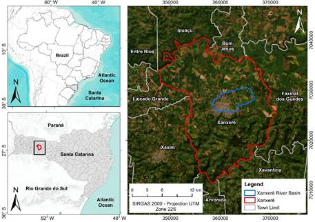
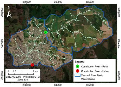
The study area comprises the portion of the Xanxerê River basin upstream of BR-282, with a drainage area of 26.15 km² (Figure 1). The basin under study is characterized by predominantly agricultural use in the upstream portion and the presence of the urban area of the municipality of Xanxerê in the downstream portion of the basin. The study considers the predominantly rural contributing basins and the basin with the outlet upstream of BR-282 (Figure 2).
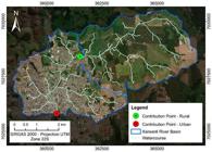
The region's climate, according to the Köppen classification, is classified as Humid subtropical (C) Ocean Climate (f) with hot summers(a) or Cfa. The average monthly temperature varies from 13.3°C in July to 22.0°C in January, with an annual average of 18.3°C. The average monthly rainfall varies from 144.2 mm in March to 232.5 mm in October, with an annual total of 2075.7 mm. Rainfall erosivity is classified as high, with an R-factor of 9134 MJ ha⁻¹ mm⁻¹ h⁻¹ year⁻¹ (Back, 2020). The predominant soils are Latosols, Cambisols, and Argisols, with gently undulating and undulating relief, which, combined with the high rainfall erosivity, favors the occurrence of water erosion.
The land use and land cover identification and classification phase were performed entirely in a computer environment using ArcGIS software (ESRI). For this process, images provided by the Environmental Systems Research Institute (ESRI) database were used, specifically the 2023 World Imagery basemap.
The definition of land use and land cover classes was carried out through manual vectorization in ArcGIS, using the tools of the Editor module and referencing the ESRI image. After vectorization, it was possible to quantify the areas corresponding to each class and thus determine the Curve Number (CN) value for each basin analyzed.
Table 1 presents soil uses for the two basins under analysis. It can be seen that the urban area corresponds to 40% of the basin being studied. Areas with temporary crops and pastureland, the object of this analysis, represent 47% of the rural area and 26% of the basin being studied.
2.2. Hydrological Study
This study uses the method developed by the Soil Conservation Study (SCS), which is adopted to predict surface runoff. The method allows the calculation of the effective rainfall and estimates the maximum runoffs in river basins.
The model is based on the CN parameter that aims to describe the type of soil use and land surface conditions in relation to their potential to create surface runoffs.
The maximum runoffs were estimated by the SCS Hydrographic method (McCuen, 1982), considering three conditions for soil management and conservation in rural areas. The first condition considers its current use with conventional farming, without the use of terracing practices. The second condition considers the implementation of drainage or gradient terracing in farmland or pastureland areas. The third condition considers the use of level or infiltration terracing in farmland or pastureland areas.
Terraces were designed according to the recent experience of technicians from the Agricultural Research and Rural Extension Company of Santa Catarina (Epagri) (Back et al., 2021). Level terraces are designed with a depth of approximately 50 cm, with a channel area of 1.3 -1.5 m² per linear meter of terrace. The spacing varies according to the slope of the terrain. Gradient terraces are designed for maximum flow with a return period of 10 to 20 years and channel slope varying from 0.1 to 0.5%.
The effect of introducing terracing was evaluated with the alteration of the CN coefficient in these areas. For the current condition (without terracing) and that of the use of drainage terracing, the CN values indicated by Chow et al. (1988) and USDA-NRCS (2021b) were considered, as detailed in Table 2.
For level terracing, the methodology of Pruski et al. (2001) was considered, where surface runoff is estimated by the IDF equation, also taking into account the time and return of 20 years and a water infiltration index of 30 mm h-1, hence obtaining the volume of water stored in the terracing as equivalent to 51 mm of rain. When adopting this value as an initial abstraction for the SCS method, a CN equivalent to 50 is obtained. The infiltration rate is an important factor in the methodology of Pruski et al. (2001)). The value of 30 mm.h-1 adopted is consistent with the average values measured using a Cornell infiltrometer in the western region of Santa Catarina (Back et al., 2021).
The Equation 1 of intense rainfall for Chapecó (Back and Wildner, 2022) was used, expressed by:
Where:
i = rainfall intensity (mm/h);
T = return period (years);
t = rainfall duration (min).
Table 3 contains the morphometric parameters of the basins analyzed with the CN values adopted in this study. The average declivity of the basin in the rural area is 12% and therefore adequate for terracing practices.
The results obtained are derived from simulations performed on a conceptual basis, and no calibration or validation studies have been conducted. Therefore, the values should be interpreted as potential results based on the values reported for each parameter in the model.
3. RESULTS AND DISCUSSION
Table 4 contains the respective runoff for each simulated situation. A significant reduction in the effective rainfall can be observed for level terracing due to the greater reduction of the CN value.
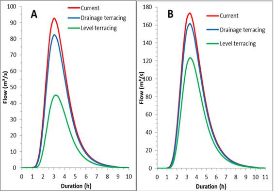
Figure 3 shows the hydrographs for rainfall with T = 50 years for the rural area (Figure 3A) and the entire basin (Figure 3B). Table 5 contains the numbers for peak runoff for each of the scenarios evaluated.
For the rural basin, the implementation of gradient terracing reduces peak runoff by about 10%, while with level terracing this reduction is around 50%. For the area, adopting gradient terracing reduces peak runoff about 7%, while with the use of level terracing this reduction is about 25 to 32%.
The results obtained are supported by several studies on the effectiveness of terracing in reducing water and soil losses. Aguiar et al. (2020) conducted an extensive revision regarding surface runoffs with different types and uses of soil and concluded that the rate in natural rain events varies from 0.06% to 84% in relation to total rainfall for different types and uses of soil. Carvalho et al. (2009), when comparing different techniques of soil conservation, demonstrated the efficacy of terracing in reducing surface runoffs. Londero et al. (2021), based on the monitoring of zero-order paired basins with and without terracing, concluded that the use of terracing reduced the volume of surface runoffs in almost 90% and maximum flow in almost 90% as well, demonstrating its superiority as a conservationist practice in controlling surface runoffs. Deng et al. (2021) highlight that terracing provides many ecosystemic services, including a reduction in surface and sedimentary runoff of over 41.9% to 52%, respectively, as well as an improvement in grain production and soil moisture content of 44.8% and 12.9%, respectively.
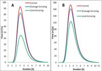
Maximum estimated runoff with a return period of 50 years for rural basins (A) and total basin (B).
The study considered a 3.6% reduction in the CN value with drainage terraces and a 19.5% reduction in CN with the use of level terraces. Although no calibration was performed, the values are consistent with the experimental observations of Barbosa et al. (2025), who measured a 21% reduction in CN with the introduction of level terraces. Werle et al. (2025) also obtained experimental results with peak flow reductions of up to 28% when terracing was included among soil conservation practices.
A high level of runoff reduction with level terracing was also observed by Oliveira et al. (2012) who state that mixed terracing presents lower efficiency in its capacity to store surface water than level terracing, though higher efficiency than drainage terracing, which has direct consequences for water loss.
This study only included terracing in temporary crop and pastureland areas. Nevertheless, even in the rural area there are large tracts for different uses, among which farm are uses that can be included in the soil conservation program with the adoption of terracing and other soil and water conservation practices. A detailed revision of these areas is recommended to assess the potential for soil and water conservation practices.
It is also recommended that pastureland conditions be assessed. Confessor et al. (2022) stress that pastures present variable quality and abundance through time and space and that the type of management, whether it be conservationist practices, occupancy or use of fertilization, affects pasture quality and consequently soil and water loss. Although several studies have shown that pastures reduce soil loss, there are others that demonstrate that pastures increase soil density and the rate of erosion, as well as surface runoffs, leading to the formation of grooves and gulches (Evans, 1998; Thomaz, 2005). Cassol et al. (2002) point out that erosive rainfall on soil during sowing and after grazing may cause soil and water loss. The magnitude of these losses depends on surface conditions resulting from soil and sowing preparation operations of the forage species being used. The problems of pastureland erosion are more acute in temporary pastures, rotating with croplands.
The results presented are based on the hypothesis that every farm area with annual crops be terraced, which may not be feasible in practice. However, these results demonstrate the potential - besides erosion control - of soil conservation practices for improving soil and water conditions in rural areas, contributing significantly to the reduction of peak runoff, while also mitigating floods in urban areas.
It is also important to consider that adopting terracing practices requires producer awareness and knowledge of the bases or pillars of conservation agriculture. Telles et al. (2022), in field research in the state of Paraná, found that 67% of the farmers interviewed did not adequately understand the pillars of conservation agriculture, and some farmers had implemented them only partially.
Melo et al. (2023) also highlight that in Brazil, conserving soil and water requires the adoption of the technological package of conservation agriculture, together with contour planting and the use of agricultural terraces. However, the authors found that only 26.8% of farmers had adopted conservation agriculture. Overall, they found that most farmers adopt conservation measures, but only partially, which may not be sufficient to guarantee soil and water conservation. Awareness of soil and water conservation needs to be improved.
Macedo et al. (2009) affirm that terracing should always be associated with other conservationist practices such as contour farming, retention strip planting, crop rotation, vegetal barriers, weeding rotation and mulching. Bertoni and Lombardi Neto (1985) state that terracing is more effective when done in combination with other practices such as, for example, leveled planting, strip crops and no-till systems.
Furthermore, there is the possibility of storing part of the surface runoff and retention basins both in urban and rural areas, which can aid in reducing runoff peaks. The construction of reservoirs and small dams, besides being a source of water for irrigation and animals, can contribute in reducing maximum runoff.
It is important to highlight that sustainable drainage practices in urban areas can also be encouraged. Measures such as collecting rainwater, detention basins, and infiltration trenches can help reduce runoffs in urban areas.
An economic analysis is recommended to evaluate the cost of the structural measures of conventional drainage and compare them with the costs of terracing and reservoir practices in rural areas. This study has demonstrated the feasibility of such practices in rural areas with less environmental impact, disruptions to the population and lower costs than the structural measures carried out in urban areas.
Silva et al. (2017) discusses the prospects for environmental conservation and ecosystem services in coupled rural-urban systems, where, using a territorial and integrative approach based on ecological and socioeconomic factors, they envision innovative policies and initiatives aimed at reconciling urban economic development with rural conservation and restoration projects. In the case of Xanxerê, payment for environmental and soil conservation services can also be included, with benefits for both rural and urban areas.
4. CONCLUSIONS
The results show that adopting conservation practices in rural areas can effectively address urban drainage problems. Level terraces are more efficient at reducing runoff, with a reduction of approximately 50% of peak flow.
The results obtained show that adopting soil conservation practices, including terracing, can bring benefits to both rural and urban areas. An integrated watershed management plan with public policies for a conservation management program is necessary.
5. DATA AVAILABILITY STATEMENT
Data availability not informed.
6. REFERENCES
-
AGUIAR, T. C.; SPLETOZER, A. G.; SILVEIRA, L. J.; BARBOSA, R. A.; DIAS, H. C. T. Escoamento superficial em diferentes tipos e usos do solo: Revisão sistemática entre 2000 e 2020. In: MELLO, R. G.; FREITAS, P. G. (Orgs.). Meio ambiente: Gestão, preservação e desenvolvimento custeável. Rio de Janeiro: EPublicar, 2020. p. 435-452. https://doi.org/10.47402/ed.ep.c202182228486
» https://doi.org/10.47402/ed.ep.c202182228486 - BACK, Á. J.; WILDNER, L. P. HidroTerraço 1.0 - Programa para cálculos hidrológicos e dimensionamento de estruturas de conservação do solo e da água em áreas agrícolas. Florianópolis: Epagri, 2022. 124p. (Epagri. Documentos, 348).
-
BACK, Á. J.; GARCEZ, J.; WILDNER, L. P.; BASSANI, M. H.; GOLIN, A. S. O reconhecimento do terraceamento como prática de agricultura conservacionista em Santa Catarina, Brasil. Brazilian Journal of Development, v. 7, n. 12, p. 119048-119066, 2021. https://doi.org/10.34117/bjdv7n12-595
» https://doi.org/10.34117/bjdv7n12-595 - BACK, Á. J. Informações climáticas e hidrológicas dos municípios catarinenses (com programa HidroClimaSC). Florianópolis: Epagri, 2020. 157p.
-
BARBOSA, A. A.; PAULOA, A. L.; SANTOS, E. L.; BARBOSA, F. T.; GIAROLA, N. F. B. Use of agricultural terraces to control water loss on slopes Cultivated with grains under a no-tillage system. Engenharia agrícola, v. 45, n. 1, 2025. https://doi.org/10.1590/1809-4430-Eng.Agric.v45nespe120240186/2025
» https://doi.org/10.1590/1809-4430-Eng.Agric.v45nespe120240186/2025 - BERTONI, J.; LOMBARDI NETO, F. Conservação do solo. Piracicaba: Livroceres, 1985. 392p.
-
BISOLO, A.; RODRUGUES, M. F.; CONCEIÇÃO, F. G.; PELLEGRINI, A. Spatial Variability and Correlation between Soil Physical Properties under No-Tillage with and without Agricultural Terraces. Brazilian Archives of Biology and Technology, v. 67, spe 1, 2024. https://doi.org/10.1590/1678-4324-PSSM-2024230802
» https://doi.org/10.1590/1678-4324-PSSM-2024230802 -
CARVALHO, D. F.; CRUZ, E. S.; PINTO, M. F.; SILVA, L D. B.; GUERRA, J. G. Características da chuva e perdas por erosão sob diferentes práticas de manejo do solo. Revista Brasileira de Engenharia Agrícola e Ambiental, v. 13, n. 1, p. 3-9, 2009. https://doi.org/10.1590/S1415-43662009000100001
» https://doi.org/10.1590/S1415-43662009000100001 -
CASSOL, E. A.; LEVIEN, R.; ANGHINONI, I.; BADELUCCI, M. P. Perdas de nutrientes por erosão em diferentes métodos de melhoramento de pastagem nativa no Rio Grande do Sul. Revista Brasileira de Ciência do Solo, v. 26, p. 705-712, 2002. https://doi.org/10.1590/S0100-06832002000300015
» https://doi.org/10.1590/S0100-06832002000300015 - CHOW, V. T.; MAIDMENT, D. R.; MAYS, L. W. Applied Hydrology. New York: McGraw-Hill, 1988.
-
CONFESSOR, J. G.; SILVA, L. L.; ARAÚJO, P. M. S. Avaliação das perdas de água e solo em pastagem inserida em ambiente de Cerrado Brasileiro sob chuva simulada. Sociedade e Natureza, v. 34, 2022. https://doi.org/10.14393/SN-v34-2022-65618
» https://doi.org/10.14393/SN-v34-2022-65618 -
DENG, C.; ZHANG, G.; LIU, Y.; NIE, X.; LI, Z.; LIUM, J. et al Advantages and disadvantages of terracing: A comprehensive review. International Soil and Water Conservation Research, v.9, p.344-359, 2021. https://doi.org/10.1016/j.iswcr.2021.03.002
» https://doi.org/10.1016/j.iswcr.2021.03.002 -
DIDONÉ, E. J.; MINELLA, J. P. G.; EVRARD, O. Measuring and modelling soil erosion and sediment yields in a large cultivated catchment under no-till of Southern Brazil. Soil and Tillage Research, v. 174, p. 24-33, 2017. https://doi.org/10.1016/j.still.2017.05.011
» https://doi.org/10.1016/j.still.2017.05.011 -
EVANS, R. The erosional impacts of grazing animals. Progress in Physical Geography, v. 22, n. 2, p. 251- 268, 1998. https://doi.org/10.1177/030913339802200206
» https://doi.org/10.1177/030913339802200206 -
FALCÃO SOBRINHO, J.; BARBOSA, F. E. L. Perdas de solo em área agrícola do Semi-Árido Mercator, v. 21, 2022. https://doi.org/10.4215/rm2022.e21020
» https://doi.org/10.4215/rm2022.e21020 -
FLUMIGNAN, D. L.; GOMES, L. D.; MOTOMIYA, A. V. A.; OLIVEIRA, G. Q.; VIEIRA FILHO, P. S. Soil cover is strategic to remedy erosion in sandy soils. Engenharia Agrícola, v. 43, n. 1, 2023. https://doi.org/10.1590/1809-4430-Eng.Agric.v43n1e20220047/2023
» https://doi.org/10.1590/1809-4430-Eng.Agric.v43n1e20220047/2023 -
FREITAS, L. R.; GUBIANI, P. I.; MULAZZANI, R. P.; MINELLA, J. P. G.; LONDERO, A. L. Terracing increases soil available water to plants in no-tillage. Revista Brasileira de Ciência do Solo, v. 45, 2021. https://doi.org/10.36783/18069657rbcs20210046
» https://doi.org/10.36783/18069657rbcs20210046 -
FUENTES-GUEVARA, M. D.; SPLIETHOFF, J.; CAMILO, E. L.; GARCIA NETO, E.; OLANIK, C.; PACHECO, A. A. et al Mixture of winter cover crops reduces surface runoff and sediment production under no-tillage system for Oxisols. Land Degradation & Development, v. 35, n. 6, 2024. https://doi.org/10.1002/ldr.5050
» https://doi.org/10.1002/ldr.5050 -
HERNANDEZ-GUZMAN, R.; ONCHI-RAMUCO, N. L. Estimating surface runoff using the curve number method in an ungauged watershed in Jalisco, Mexico evaluating its morphometric parameters. Earth Sciences Research Journal, v. 26, n. 4, p. 313-320, 2020. https://doi.org/10.15446/esrj.v26n4.99194
» https://doi.org/10.15446/esrj.v26n4.99194 - LOMBARDI NETO, F.; BELLINAZZI JR., R.; LEPSCH, I. F.; OLIVEIRA, J. B.; BERTOLINI, D.; GALETI, P. A. et al Terraceamento agrícola. In: LOMBARDI NETO, F.; DRUGOWICH, P. I. Manual técnico de manejo e conservação do solo e da água. Campinas: CECOR - CATI, 1994. p. 1-34.
-
LONDERO, A. L.; MINELLA, J. P. G.; DEUSCHLE, D.; SCHNEIDER, F. J. A.; BOENI, M.; MERTEN, G. H. Impact of broad-based terraces on water and sediment losses in no-till (paired zero-order) catchments in southern Brazil. Journal of Soils and Sediments, v.18, p. 1159-75, 2018. https://doi.org/10.1007/s11368-017-1894-y
» https://doi.org/10.1007/s11368-017-1894-y -
LONDERO, A. L.; MINELLA, J. P. G.; SCHNEIDER, F. J. A.; DEUSCHLE, D.; MENEZES, D.; EVRARD, O. et al Quantifying the impact of no‐till on runoff in southern Brazil at hillslope and catchment scales. Hydrological Processes, v. 35, 2021. https://doi.org/10.1002/hyp.14286
» https://doi.org/10.1002/hyp.14286 - MACEDO, J. R. DE; CAPECHE, C. L.; MELO, A. S. Recomendação de manejo e conservação de solo e água. Niterói: Programa Rio Rural, 2009. 45p.
-
MAGALHÃES, G. M. F. Análise da eficiência de terraços de retenção em sub-bacias hidrográficas do Rio São Francisco. Revista Brasileira de Engenharia Agrícola e Ambiental, v. 17, n. 10, p. 1109-115, 2013. https://doi.org/10.1590/S1415-43662013001000013
» https://doi.org/10.1590/S1415-43662013001000013 -
MELO, T. R.; ASAI, G.; HIGSHI, G. E.; LORDERO, A. L.; BARBOSA, G. M. C.; TELLES, T. S. Perception and level of soil and water conservation practices adoption by farmers in a watershed. Revista Ciência Agronômica, v. 54, 2023. https://doi.org/10.5935/1806-6690.20230004
» https://doi.org/10.5935/1806-6690.20230004 - McCUEN, R. H. A guide to hydrologic analysis using SCS methods. Englewood Cliffs: Prentice-Hall, 1982. 176p.
-
OLIVEIRA, J. R. S.; PRUSKI, F. F.; SILVA, J. M. A.; SILVA, D. P. Comparative analysis of the performance of mixed terraces and level and graded terraces. Acta Scientiarum Agronomy, v. 34, n. 4, 2012. https://doi.org/10.4025/actasciagron.v34i4.14755
» https://doi.org/10.4025/actasciagron.v34i4.14755 -
PRUSKI, F. F.; GRIEBELER, N. P.; SILVA, D. D. Comparação entre dois métodos para a determinação do volume de escoamento superficial. Revista Brasileira de Ciência do Solo, v. 25, n. 2, p. 403-410, 2001. https://doi.org/10.1590/S0100-06832001000200016
» https://doi.org/10.1590/S0100-06832001000200016 -
SILVA, R. F.; RODRIGUES, M. D. A.; VIEIRA, S. A.; BATISTELLA, M.; FARINACI, J. Perspectives for environmental conservation and ecosystem services on coupled rural-urban systems. Ecology and Conservation, v. 15, p. 74-81, 2017. https://doi.org/10.1016/j.pecon.2017.05.005
» https://doi.org/10.1016/j.pecon.2017.05.005 -
TELLES, T. S.; MELO, T. R.; RIGHETTO, A. J.; DIDONÉ, E. J.; BARBOSA, G. M. C. Soil management practices adopted by farmers and how they perceive conservation agriculture. Revista Brasileira de Ciência do Solo, v. 46, 2022. https://doi.org/10.36783/18069657rbcs20210151
» https://doi.org/10.36783/18069657rbcs20210151 - THOMAZ, E. L. Processos hidrogeomorfológicos e o uso da terra em ambiente subtropical - Guarapuava - PR. 2005. 297 f. Tese (Doutorado em Ciência, área Geografia Física) - Faculdade de Filosofia Letras e Ciências Humanas, Universidade de São Paulo, São Paulo, 2005.
- TRIGUEIRO, R. M. Ciência do solo: física e conservação do solo e água. Londrina: Educacional, 2019. 192p.
- UNITED STATES. Department of Agriculture. Natural Resources Conservation Service. Chapter 2. Estimating Runoff Volume and Peak Discharge. In: USDA. Part 650 Engineering Field Handbook. National Engineering Handbook. 2nd ed. Washington, 2021a. 43p.
- UNITED STATES. Department of Agriculture. Natural Resources Conservation Service. Chapter 14. Water management (drainage). In: USDA. Part 650 Engineering Field Handbook. National Engineering Handbook. 2nd ed. Washington, 2021b. 43p.
-
VALLE JUNIOR, L. C. G. do; RODRIGUES, D. B. B.; OLIVEIRA, P. T. S. de. Initial abstraction ratio and Curve Number estimation using rainfall and runoff data from a tropical watershed. RBRH, v. 24, p. e5, 2019. https://doi.org/10.1590/2318-0331.241920170199
» https://doi.org/10.1590/2318-0331.241920170199 - WADT, P. G. S. Construção de terraços para controle de erosão pluvial no Estado do Acre. Rio Branco: Embrapa Acre, 2003. 44p.
-
WERLE, L.; MINELLA, J. P. G.; MERTEN, G. H.; KAISER, D. R.; SCHLESNER, A.; DAMBROZ, A. P. B. et al Modeling the effect of terracing on runoff control in a rural catchment in southern Brazil. Revista Brasileira de Ciência do Solo, v. 49, 2025. https://doi.org/10.36783/18069657rbcs20240108
» https://doi.org/10.36783/18069657rbcs20240108
Edited by
-
Editor-in-Chief:
Editor-in-Chief: Nelson Wellausen Dias https://orcid.org/0000-0002-9507-9211