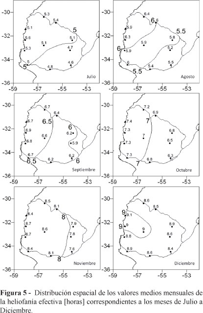
The spatial coverage of land measurement networks cannot fulfill all the user's needs because their density is low; and this fact becomes more important in the case of solar radiation. The scarcity of global irradiation data is the reason for using sunshine hours in order to estimate them through different correlations which have shown a good fit with the measurements data. In order to draw charts with the spatial distribution of the sunshine-hours monthly averages (and from them, global solar radiation charts also) on such a vast territory as South America, it is necessary to study the error-distance relationship between stations in homogeneous zones. For that purpose, it is usual to analyze the spatial behavior of certain statistics of a random data such as, for example, the structure function. In this paper, sunshine-hours monthly data from Uruguay were used and their variation according to the distance between stations was analyzed. Several graphs, corresponding to different periods within the year are presented, analyzing the spatial extrapolation conditions of the information. Also, the results of the statistical analysis of the annual mean values of the time series of sunshine-hours, using the Mann-Kendall rank test were presented. Finally, 12 charts with the space distribution of sunshine-hours monthly averages were presented.
Sunshine hours; temporal and spatial behavior; Uruguay


