Abstract
The study identifies the Canastra-3 Kimberlite magnetic anomaly as the likely primary source of the alluvial diamonds recovered by "garimpeiros" in the Santo Antônio River basin (Delfinópolis, southwestern Minas Gerais). This conclusion is based on cumulative geophysical, hydrographic, metallogenical and mineral geochemistry evidences. The study area is located within fertile ground in the border of the São Francisco craton, close to other diamond primary sources and secondary deposits. This kimberlitic target is the only known in the Santo Antônio River basin. In addition, the known mineralized gravels of this river, worked in the past by "garimpeiros", have evidence of a short transport (angular pebbles and blocks), further evidence of a nearby source. The original data collected in the "Minas Gerais Aerogeophysical Survey Program" was processed and analyzed with the Euler Deconvolution method, implemented in software Oasis Montaj. With the exception of the Canastra-3 body anomaly, all others in the study were classified as non-kimberlitic. Recent sampling work on the weathered top of the Canastra-3 Kimberlite recovered indicator minerals, notably a high proportion of pyrope garnets of the G-10 type, which is unusual among the kimberlites of the region.
Keywords:
diamond; Santo Antônio River; Canastra-3 Kimberlite; geophysical prospection
1. Introduction
Minas Gerais and its neighboring areas are home to some diamond provinces with geographic, mineralogical and geotectonic affinities. These provinces encompass tens of thousands of square kilometers. The Serra da Canastra diamond province is the focus of this study, and stands out as the first in Minas Gerais where a direct link has been identified between alluvial diamond deposits and their primary source - the Canastra-1 Kimberlite in the Vargem Bonita area, in the headwaters of the São Francisco River. The study attempts to establish a similar dependence link between the secondary diamond deposits located on alluvial terraces in the Santo Antônio River, near Delfinópolis town, with some magnetic anomalies recognized upstream from them.
The Santo Antônio River basin has a very restricted extent, which facilitated a study with this objective. The field characterization of these magnetic anomalies and chemical mineral analyses of Cr-pyrope garnets sampled at the location of the Canastra-3 magnetic anomaly are used to reinforce the hypotheses that it is likely of kimberlitic nature and source of the diamonds found in the Santo Antônio River terraces. Furthermore, in situ research and new mineralogical studies on other indicator minerals are being conducted to support these hypotheses.
This article represents a continuation of the geological research on kimberlites in the Canastra Range region (Chaves et al. 2008aCHAVES, M. L. S. C. et al. Província diamantífera Serra da Canastra e o kimberlito Canastra-1: primeira fonte primária de diamantes economicamente viável do país. Geociências, v. 27, p. 299-317, 2008a.,b), as well as mineralogical studies by electron microprobe on the indicator minerals present in these intrusions, as part of a Masters Dissertation of one of the authors (Andrade, 2012ANDRADE, K.W. Química de minerais indicadores de intrusões kimberlíticas com ênfase na Província Diamantífera Serra da Canastra (MG): importância na prospecção de intrusões férteis. 2012. 153f. Dissertação (Mestrado em Geologia) - Instituto de Geociências - IGC, Universidade Federal de Minas Gerais, Belo Horizonte, 2012.).
2. Location and geological setting
The Santo Antônio River basin is located at the southern portion of the Canastra Mountain Range, southwest of Minas Gerais State and to the north of Delfinópolis small town (Figure 1), with springs in this range directed to Grande River (Peixoto's Dam). Although a large portion of the diamond province shows a drainage pattern converging with the São Francisco basin, in this area the rivers flow to the Grande River basin. The two major streams that constitute the headwaters of the basin here studied have their own names: Babilônia and Das Posses creeks.
Geological setting of Serra da Canastra Diamond Province showing the Santo Antônio River and the Canastra-3 Kimberlite location in the central portion of the map (the Canastra-1 Kimberlite position also is showed) focused on the present study (modified from Heineck et al., 2003).
Heineck et al. (2003) identified the oldest rocks of this region as belonging to the Pium-hí Group, a metavolcanic and metasedimentary sequence of Archean age. Mesoproterozoic (?) quartzites and schists of the Canastra Group sustain the mountain range; these two units are thrust faults covered by the Bambuí Group pelites and carbonates, of Neoproterozoic age (Figure 1). The Araxá Group, also of uncertain age, is represented by a thick package of schist rocks, outcropping south of the Canastra Group, and constitutes the bedrock of the studied alluvial diamond deposits. The tectonic evolution of the Neoproterozoic Brasília Fold Belt in this region has been reviewed by Pimentel et al. (2011)PIMENTEL, M. A. et al. The tectonic evolution of the Neoproterozoic Brasília Belt, central Brazil, based on SHRIMP and LA-ICPMS U-Pb sedimentary provenance data: a review. Journal of South American Earth Sciences, v. 31, p. 345-357, 2011..
The geological framework is complemented by Mesozoic sedimentary rocks from the Paraná Basin, to the southeast, and chronologically correlated rocks from the Sanfranciscana basin to the northeast. Several kimberlite intrusions occur mainly along the spine of the Canastra Range, cutting quartzites of the Canastra Group. Canastra-1 Kimberlite is the only dated rock body in the region, with a Lower Cretaceous age (120±10 Ma, K/Ar in flogopite), according to Pereira and Fuck (2005)PEREIRA, R. S.; FUCK, R. A. Archean nucleii and the distribution of kimberlite and related rocks in the São Francisco craton, Brazil. Revista Brasileira de Geociências, v. 35, p. 93-104, 2005..
The geotectonic setting of the region remains the subject of intense controversy. The classic southern boundary attributed to the San Francisco Craton is about 50-60 km to the east, where the Archean basement (Pium-hí Group) and Upper Peoproterozoic Bambuí Group outcrop (Figure 1). Such configuration would make the Canastra region unpromising in terms of potential to contain fertile diamond-bearing intrusions. However, Pires (1984) PIRES, F. R. M. The southern limits of São Francisco craton. Anais da Academia Brasileira de Ciências, v. 58, p. 139-145, 1984. argued that the actual cratonic boundary would be farther to the west, and thus the Lower Neoproterozoic metasedimentary cover (Canastra, Ibiá and Araxá groups) would not have affected the large underlying faults, which would be the ducts of kimberlitic magmatism. The reactivation of such faults during the Mesozoic could have facilitated the emplacement of the intrusions.
3. Diamond alluvial deposits and possible primary sources
Diamond-bearing gravels in alluvial terraces are known in the Santo Antônio River since the beginning of the 1960's, being intermittently mined by panhandling until the late nineties. The singularity of the basin, which cuts the Canastra Quartzite, has provided few trapping points on the current bed, which have not been mined. Thus, only the river terraces have been worked on several localities of its lower course (Figure 2), raised from 8 to 10 meters above the current channel. Some brief previous references about these deposits are available in Barbosa et al. (1970)BARBOSA, O. et al. Geologia da região do Triângulo Mineiro. Rio de Janeiro: DNPM/DFPM, 1970. 140 p. (Boletim 136).; Bardet (1977)BARDET, M. G. Geologie du Diamant. Paris: Memoires du BRGM, 1977. v. 3.; Fonseca et al. (1979)FONSECA, M. J. G. et al. Carta geológica do Brasil ao milionésimo: folhas Rio de Janeiro (SF-23), Vitória (SF-24) e Iguape (SG-23): texto explicativo. Brasília: DNPM, 1979. 240p. ; and Chaves et al. (2008aCHAVES, M. L. S. C. et al. Província diamantífera Serra da Canastra e o kimberlito Canastra-1: primeira fonte primária de diamantes economicamente viável do país. Geociências, v. 27, p. 299-317, 2008a.,b)CHAVES, M. L. S. C. et al. Kimberlito Canastra-1 (São Roque de Minas, MG): geologia, mineralogia e reservas diamantíferas. REM - Revista da Escola de Minas, v. 61, p. 357-364, 2008b.. The thickness of the alluvial sediments varies from a few decimeters to 1 meter, composed mainly by angular pebbles and blocks of quartz and quartzite.
Main magnetic anomalies - analytical signal - from Santo Antônio River basin, north of Delfinópolis town (treated and interpreted from CODEMIG, 2005-2006COMPANHIA DE DESENVOLVIMENTO ECONÔMICO DE MINAS GERAIS. Levantamento aerogeofísico de Minas Gerais, Área 7 - Patos de Minas, Araxá, Divinópolis, Magnetometria - Mapa de Sinal Analítico. Belo Horizonte: CODEMIG, 2005-2006, 11 DVDs.; Area 7).
Since the early 2000s, the State of Minas Gerais has been surveyed by the Minas Gerais Development Company (CODEMIG) in an aerogeophysical program. The Canastra region was included in the "Area 7", mapped on a 1:100,000 scale with flight spacing of 400 m (CODEMIG, 2005-2006), where several kimberlite intrusions are described. Potentially kimberlitic anomalies can be described by the dipole model (Telford et al., 1990), which represents a small three dimensional structure containing anomalous concentrations of magnetic materials and varying in section from rod-like to spherical. Keating (1995)KEATING, P. A simple technique to identify magnetic anomalies due to kimberlite pipes. Exploration and Mining Geology, v. 4, p. 121-125, 1995. and Keating and Sailhac (2004) KEATING, P.; SAILHAC, P. Use of the analytic signal to identify magnetic anomalies due to kimberlite pipes. Geophysics, v. 69, n. 1, p. 180-190, 2004. also describe a model applied to identify kimberlitic bodies, using a vertical cylinder to observe factors that influence the shape of the anomalies: magnetic susceptibility contrast, the solid depth and dimensions and magnetic declination.
The most representative magnetic anomalies of the basin were initially divided into two groups: extensive linear (Figure 2, indicated with dashed lines - A) and point circular (Figure 2, indicated with arrows - B). The first ones correspond to the tops of the mountain alignments, where the development of a thick ferruginous laterite crust was observed in field works. After the treatment of these anomalies using the "Euler Deconvolution" modern technique (Thompson, 1982THOMPSON, D. T. EULDPH: a new technique for making computer-assisted estimates from magnetic data. Geophysics, v. 47, p. 31-37, 1982.; Durrheim and Cooper, 1998DURRHEIM, R. J.; COOPER, G. R. J. EULDEP: a new program for the Euler deconvolution of magnetic and gravity data. Computers & Geosciences, v. 24, p. 545-550, 1998.), they disappear through a cut in cross section at 50 m depth, evidencing that the crusts have smaller thicknesses than this one.
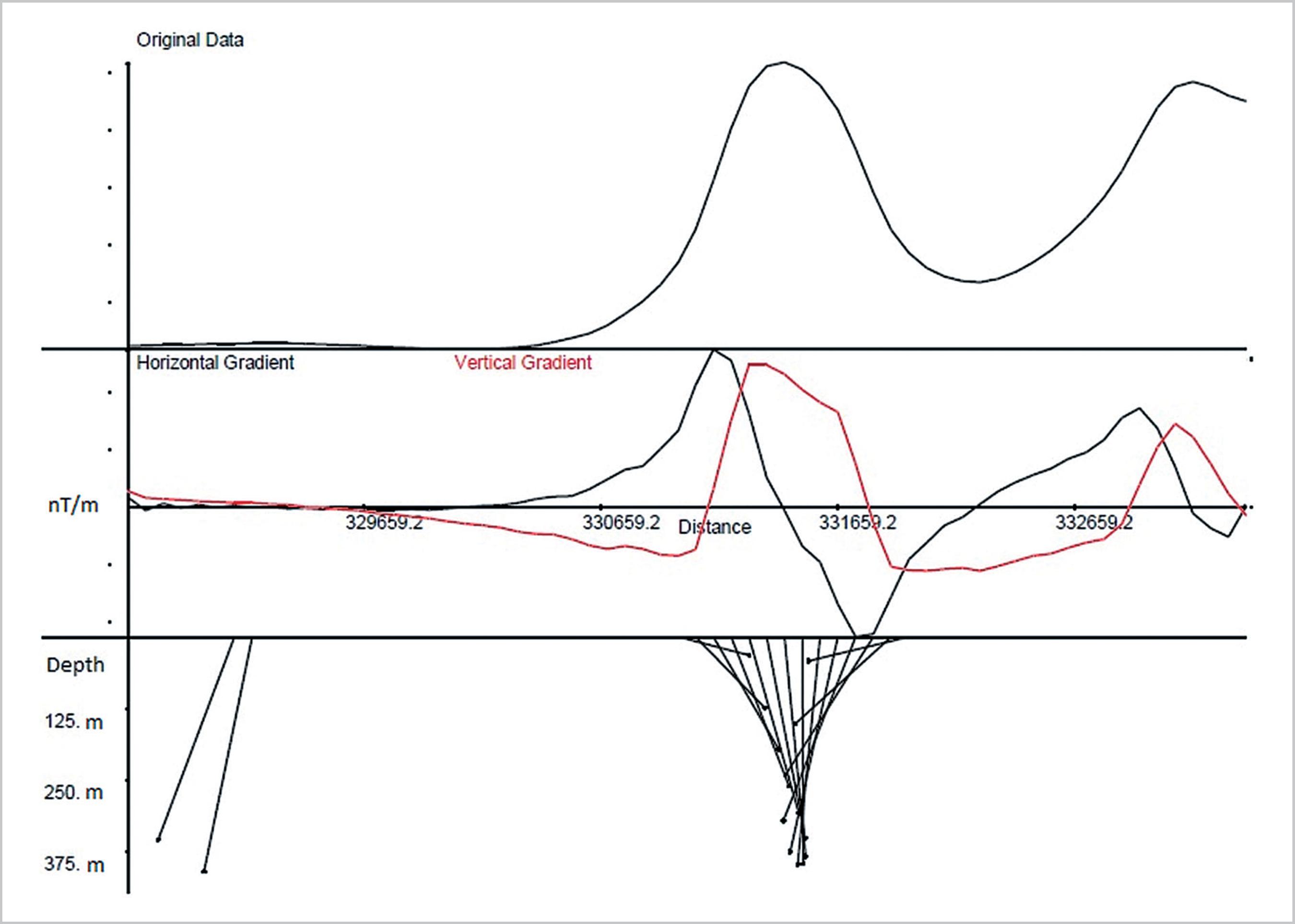
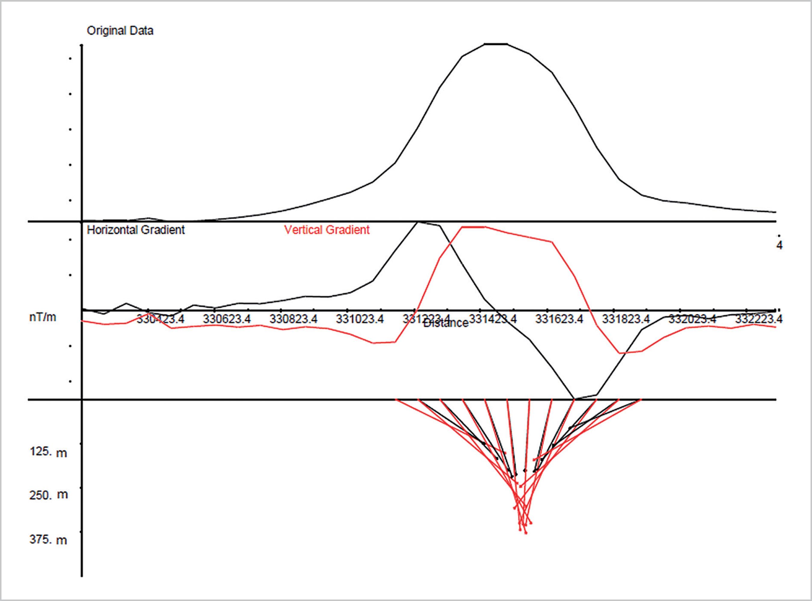
In short, the Euler Deconvolution makes use of the amplitudes of the analytical signal in the aerogeophysical surveys to derive the horizontal coordinates (x,y) and to estimate the depth of the source through the vertical coordinate (z) of maxim amplitude. The software ARCGIS is used to trace N-S and E-W profiles over each circular anomaly (Figures 3 and 4). These profiles are exported to software OASIS MONTAJ used to assign the magnetic values to each point of the profiles, that are exported to the free access software EULER 1.0 developed by the Witwatersrand University (South African Republic). This technique estimates the depth of the magnetic anomalies through the minimum square inversion of the magnetic values and user-defined structural indexes.
E-W "Euler Deconvolution" final profile processed on Canastra-3 Kimberlite anomaly.
The upper part represents the geophysical profile, intermediary portion shows vertical and horizontal gradient from profile data, and in the lower part, the depth estimative can be seen according to pre-defined parameters from the anomaly cause.
Three point circular anomalies were checked in the field (Figure 2 - B1, B2 and B3), however in none of these were there fresh outcrops. The anomaly B3 corresponds to the kimberlite body known as "Canastra-3", discovered and named by the south African SOPEMI-De Beers mining company in 1970s6 (Geologist Luigi Giglio, verbal communication, 2008). The treatments of these structures by "Euler Deconvolution" showed that the designated B1 and B2, when cut to a depth of 50 m, no longer show the magnetic anomaly. Due to their topographical positions, on transversally fractured mountain spines, they are assumed to represent ferruginous talus deposits supplied in part from laterite erosion.
Furthermore, in the anomaly related to the Canastra-3 Kimberlite (Figure 2 - B3), treated in the same way, the greater depth of the structure was demonstrated. In the case of a pipe that is a subvertical linear source, it originates a field that varies with the inverse of the magnetic field. The maximum depth of 500 m in the described software presented a development in subsurface that defined, through cuts at different depths, a vertical cone-shaped body very typical of kimberlitic intrusions (e.g., Mitchell, 1986MITCHELL, R. H. Kimberlites: mineralogy, geochemistry, and petrology. New York: Plenum Press, 1986. 442 p.; Jaques, 1998JAQUES, A. L. Kimberlite and lamproite diamond pipes. AGSO Journal of Australia Geology & Geophysics, v. 14, p. 153-162, 1998.). In Figures 3 and 4, the two transversal sections (E-W and N-S) performed by means of the 2D anomaly and their subsurface expressions are represented.
N-S "Euler Deconvolution" final profile processed on Canastra-3 Kimberlite anomaly, with the same specifications of the previous profile.
There is still another important magnetic anomaly in the region (Figure 2 - B4), corresponding to another kimberlitic intrusion (named Canastra-8 Kimberlite by the extinct SOPEMI-De Beers). Although there are indicatives of diamond mineralization in this body (Chaves et al., 2008aCHAVES, M. L. S. C. et al. Província diamantífera Serra da Canastra e o kimberlito Canastra-1: primeira fonte primária de diamantes economicamente viável do país. Geociências, v. 27, p. 299-317, 2008a.), its drainage pattern is directed to the south, flowing into the Peixoto's Dam in the Grande River, and obviously, it could not be the source of Santo Antonio River's secondary deposits. However, in the same region (out of Figure 2 map) the Canastra-1 Kimberlite is mineralized at economic level, with a grade of 16 ct/100 ton and an important average value of their diamonds of US$ 180-200/ct, whose mining was suspended because of environmental questions, still under discussion (Chaves et al., 2008b).
4. Chromium pyrope mineral chemistry
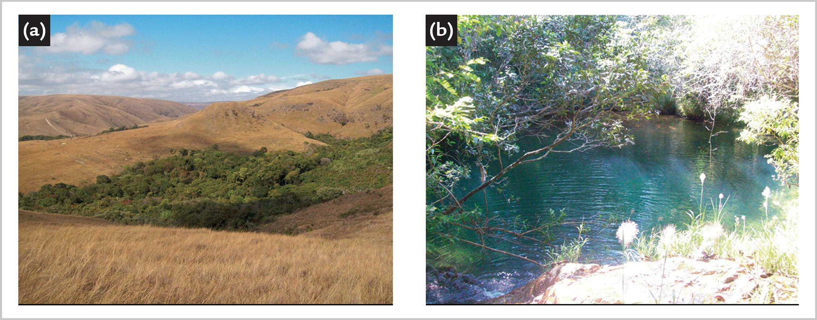
Considering that the Canastra-3 Kimberlite was the only intrusive body detected in the upstream portion of the Santo Antônio River basin, a detailed reconnaissance was made there. The current contact of the intrusion occurs in low relief in the mountain range, with the quartzite of the Canastra Group (Figure 5-a). Due to the lack of fresh outcrops, this weathered material and its residual soil was sampled, in a cut at one of the headwaters of the Babilônia Creek. (Figure 5-b). About 50 kg of material was sampled and milled at the site (Figure 6-a/b), from which heavy minerals were extracted by sieving concentrations in the thinner mesh of 1 mm (Figure 6-c/d).
(a) Physiographic aspect from the area where the Canastra-3 kimberlite occurs, showing its low relief expression and dense vegetation. (b) Inside its deepest portion, there is a small lagoon, which constitutes one of the possible springs of Santo Antonio River.
(a) Sample profile of altered rock and soil to heavy minerals concentration. (b) General aspect of this weathered rock. (c) Concentration process by gravimetry using sieving of the tired material. (d) Manual sampling of the heavy material to later laboratory study.
The field concentrate was further processed in the laboratory, and again separated into the sieve fractions 0.25 mm and 0.125 mm. Through binocular loupe examination, the minerals from alluvial prospecting were recognized by their optical properties, being identified as probable garnet, ilmenite and chromite. The red garnets with a strong purple hue (grapefruit, according to Mitchell, 1986MITCHELL, R. H. Kimberlites: mineralogy, geochemistry, and petrology. New York: Plenum Press, 1986. 442 p.) were the initial object of study by electron microprobe analysis (Microanalysis Laboratory - DEFIS/ICEX-UFMG). The obtained results were surprising (Figure 7 - limits between mineral chemistry fields according to Rombouts, 2003ROMBOUTS, L. Assessing the diamond potential of kimberlites from discovery to evaluation bulk sampling. Mineralium Deposita, v. 38, p. 496-504, 2003. and Grütter et al., 2004GRÜTTER, H. S. et al. An updated classification scheme for mantle-derived garnet, for use by diamond explorers. Lithos, v. 77, p. 841-857, 2004.): from 41 analyzed grains, 19 were plotted in the G-10 garnet-type field (or about 46%), considered to have a very high potential for diamond prospection (e.g., Dawson and Stephens, 1975DAWSON, J. B.; STEPHENS, W. E. Statistical analyses of garnets from kimberlites and associated xenoliths. Journal of Geology, v. 83, p. 589-607, 1975.; Grütter et al., 2004GRÜTTER, H. S. et al. An updated classification scheme for mantle-derived garnet, for use by diamond explorers. Lithos, v. 77, p. 841-857, 2004.).
CaO x Cr2O3 diagram of representative samples of chromium pyrope from the Canastra-3 Kimberlite.
The great majority of kimberlites in the southwestern Minas Gerais State have already been shown to have a zero or negligible fraction of G-10 chromium pyrope, which are characterized by high levels of chromium and low calcium. G-5 and/or G-9 predominate in these kimberlite bodies (e.g., Esperança et al., 1995ESPERANÇA, S. et al. The major and trace element geochemistry of garnets from the Vargem 1 kimberlite pipe, Minas Gerais state, Brazil. Anais da Academia Brasileira de Ciências, v. 67, p. 293-306, 1995.; Cookenboo, 2005COOKENBOO, H. O. Exploration for diamond-bearing kimberlite in the Brasilia Belt of Minas Gerais. In: SIMPÓSIO BRASILEIRO DE GEOLOGIA DO DIAMANTE, 4., 2005, Diamantina. Anais[...]. Diamantina: SBG-MG, 2005. p. 51-53. ; Svisero et al., 2005SVISERO, D. P. et al. Composição, origem e significado geológico de minerais resistatos de intrusões kimberlíticas da região de Coromandel, Minas Gerais. In: SIMPÓSIO BRASILEIRO DE GEOLOGIA DO DIAMANTE, 4., 2005, Diamantina. Anais[...]. Diamantina: SBG-MG, 2005. p. 169-172.), leading to intense discussions on the enigmatic source of the diamonds from the Alto Paranaíba region.
5. Conclusions
The occurrence of alluvial diamonds in Santo Antonio River's lower course, and the apparent absence of other kimberlite intrusions in its small dimension basin, allowed focusing the studies on the Canastra-3 Kimberlite, which shows strong magnetic anomaly. Based on diamond mineral indicators and chemical mineral detailed analyses, the preliminary results showed that almost half of the sampled chromium pyrope is of the G-10 type, contrasting with the G-5/G-9 groups commonly present in majority of the kimberlites from western Minas Gerais. These data point to the high potential of this intrusion and consequently, to the need for more detailed researches. The kimberlite also stands out as the first in Brazil to show (with published results) a significant percentage of the G-10 type pyrope group.
Acknowledgements
To the Italian-Brazilian geologist Luigi Giglio, the popular "Gino" (in memoriam), who indicated the position of the Canastra-3 Kimberlite to the first author, that also thanks FAPEMIG for supporting fieldwork and mineral chemistry analyses (Process CRA-APQ00165-08), and CNPq for the Research Productivity grant. Acknowledgments are extended to an anonymous reviewer, who greatly contributed to the improvement of this paper.
References
- ANDRADE, K.W. Química de minerais indicadores de intrusões kimberlíticas com ênfase na Província Diamantífera Serra da Canastra (MG): importância na prospecção de intrusões férteis. 2012. 153f. Dissertação (Mestrado em Geologia) - Instituto de Geociências - IGC, Universidade Federal de Minas Gerais, Belo Horizonte, 2012.
- BARBOSA, O. et al. Geologia da região do Triângulo Mineiro Rio de Janeiro: DNPM/DFPM, 1970. 140 p. (Boletim 136).
- BARDET, M. G. Geologie du Diamant Paris: Memoires du BRGM, 1977. v. 3.
- CHAVES, M. L. S. C. et al. Província diamantífera Serra da Canastra e o kimberlito Canastra-1: primeira fonte primária de diamantes economicamente viável do país. Geociências, v. 27, p. 299-317, 2008a.
- CHAVES, M. L. S. C. et al. Kimberlito Canastra-1 (São Roque de Minas, MG): geologia, mineralogia e reservas diamantíferas. REM - Revista da Escola de Minas, v. 61, p. 357-364, 2008b.
- COMPANHIA DE DESENVOLVIMENTO ECONÔMICO DE MINAS GERAIS. Levantamento aerogeofísico de Minas Gerais, Área 7 - Patos de Minas, Araxá, Divinópolis, Magnetometria - Mapa de Sinal Analítico Belo Horizonte: CODEMIG, 2005-2006, 11 DVDs.
- COOKENBOO, H. O. Exploration for diamond-bearing kimberlite in the Brasilia Belt of Minas Gerais. In: SIMPÓSIO BRASILEIRO DE GEOLOGIA DO DIAMANTE, 4., 2005, Diamantina. Anais[...] Diamantina: SBG-MG, 2005. p. 51-53.
- DAWSON, J. B.; STEPHENS, W. E. Statistical analyses of garnets from kimberlites and associated xenoliths. Journal of Geology, v. 83, p. 589-607, 1975.
- DURRHEIM, R. J.; COOPER, G. R. J. EULDEP: a new program for the Euler deconvolution of magnetic and gravity data. Computers & Geosciences, v. 24, p. 545-550, 1998.
- ESPERANÇA, S. et al. The major and trace element geochemistry of garnets from the Vargem 1 kimberlite pipe, Minas Gerais state, Brazil. Anais da Academia Brasileira de Ciências, v. 67, p. 293-306, 1995.
- FONSECA, M. J. G. et al. Carta geológica do Brasil ao milionésimo: folhas Rio de Janeiro (SF-23), Vitória (SF-24) e Iguape (SG-23): texto explicativo. Brasília: DNPM, 1979. 240p.
- GRÜTTER, H. S. et al. An updated classification scheme for mantle-derived garnet, for use by diamond explorers. Lithos, v. 77, p. 841-857, 2004.
- JAQUES, A. L. Kimberlite and lamproite diamond pipes. AGSO Journal of Australia Geology & Geophysics, v. 14, p. 153-162, 1998.
- KEATING, P. A simple technique to identify magnetic anomalies due to kimberlite pipes. Exploration and Mining Geology, v. 4, p. 121-125, 1995.
- KEATING, P.; SAILHAC, P. Use of the analytic signal to identify magnetic anomalies due to kimberlite pipes. Geophysics, v. 69, n. 1, p. 180-190, 2004.
- MITCHELL, R. H. Kimberlites: mineralogy, geochemistry, and petrology. New York: Plenum Press, 1986. 442 p.
- PENHA, U. C. et al. Diamante em Minas Gerais: o Projeto SIGIM-Diamante/98 e síntese geológico-exploratória. Geociências, v. 19, p. 197-208, 2000.
- PEREIRA, R. S.; FUCK, R. A. Archean nucleii and the distribution of kimberlite and related rocks in the São Francisco craton, Brazil. Revista Brasileira de Geociências, v. 35, p. 93-104, 2005.
- PIMENTEL, M. A. et al. The tectonic evolution of the Neoproterozoic Brasília Belt, central Brazil, based on SHRIMP and LA-ICPMS U-Pb sedimentary provenance data: a review. Journal of South American Earth Sciences, v. 31, p. 345-357, 2011.
- PIRES, F. R. M. The southern limits of São Francisco craton. Anais da Academia Brasileira de Ciências, v. 58, p. 139-145, 1984.
- ROMBOUTS, L. Assessing the diamond potential of kimberlites from discovery to evaluation bulk sampling. Mineralium Deposita, v. 38, p. 496-504, 2003.
- SERVIÇO GEOLÓGICO DO BRASIL. Mapa geológico do estado de Minas Gerais Belo Horizonte: COMIG, CPRM, 2003. 1 mapa, color. Escala: 1:1.000.000.
- SVISERO, D. P. et al. Composição, origem e significado geológico de minerais resistatos de intrusões kimberlíticas da região de Coromandel, Minas Gerais. In: SIMPÓSIO BRASILEIRO DE GEOLOGIA DO DIAMANTE, 4., 2005, Diamantina. Anais[...] Diamantina: SBG-MG, 2005. p. 169-172.
- TELFORD, W. M. et al. Applied Geophysics Cambridge: Cambridge University, 770p.
- THOMPSON, D. T. EULDPH: a new technique for making computer-assisted estimates from magnetic data. Geophysics, v. 47, p. 31-37, 1982.
Publication Dates
-
Publication in this collection
20 Dec 2019 -
Date of issue
Jan-Mar 2020
History
-
Received
17 Apr 2018 -
Accepted
27 Aug 2019