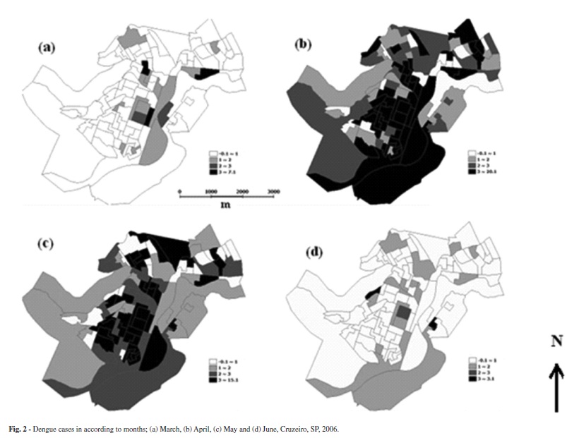
The aim of this article is to identify patterns in spatial distribution of cases of dengue fever that occurred in the municipality of Cruzeiro, State of São Paulo, in 2006. This is an ecological and exploratory study using the tools of spatial analysis in the preparation of thematic maps with data from Sinan-Net. An analysis was made by area, taking as unit the IBGE census, the analysis included four months in 2006 which show the occurrence of the disease in the city. The thematic maps were constructed by TerraView 3.3.1 software, the same software provided the values of the indicators of Global Moran (I M) every month and the Kernel estimation. In the year 2006, 691 cases of dengue were georeferenced (with a rate of 864.2 cases/100,000 inhabitants); the indicators of Moran and p-values obtained were I M = 0.080 (March) p = 0.11; I M = 0.285 (April) p = 0.01; I M = 0.201 (May) p = 0.01 and I M = 0.002 (June) p = 0.57. The first cases were identified in the Northeast and Central areas of Cruzeiro and the recent cases, in the North, Northeast and Central. It was possible to identify census tracts where the epidemic began and how it occurred temporally and spatially in the city.
Dengue; Geographic Information Systems; Epidemiologic surveillance; Ecological studies; Spatial distribution of population