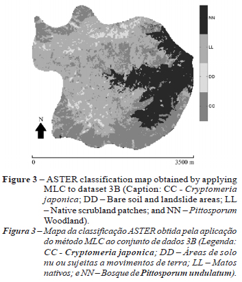
This paper aims to assess the effectiveness of ASTER imagery to support the mapping of Pittosporum undulatum, an invasive woody species, in Pico da Vara Natural Reserve (S. Miguel Island, Archipelago of the Azores, Portugal). This assessment was done by applying K-Nearest Neighbor (KNN), Support Vector Machine (SVM) and Maximum Likelihood (MLC) pixel-based supervised classifications to 4 different geographic and remote sensing datasets constituted by the Visible, Near-Infrared (VNIR) and Short Wave Infrared (SWIR) of the ASTER sensor and by digital cartography associated to orography (altitude and "distance to water streams") of which the spatial distribution of Pittosporum undulatum directly depends. Overall, most performed classifications showed a strong agreement and high accuracy. At targeted species level, the two higher classification accuracies were obtained when applying MLC and KNN to the VNIR bands coupled with auxiliary geographic information use. Results improved significantly by including ecology and occurrence information of species (altitude and distance to water streams) in the classification scheme. These results show that the use of ASTER sensor VNIR spectral bands, when coupled to relevant ancillary GIS data, can constitute an effective and low cost approach for the evaluation and continuous assessment of Pittosporum undulatum woodland propagation and distribution within Protected Areas of the Azores Islands.
Remote Sensing; Invasive species; Pittosporum undulatum