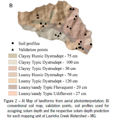
Solum depth and its spatial distribution play an important role in different types of environmental studies. Several approaches have been used for fitting quantitative relationships between soil properties and their environment in order to predict them spatially. This work aimed to present the steps required for solum depth spatial prediction from knowledge-based digital soil mapping, comparing the prediction to the conventional soil mapping approach through field validation, in a watershed located at Mantiqueira Range region, in the state of Minas Gerais, Brazil. Conventional soil mapping had aerial photo-interpretation as a basis. The knowledge-based digital soil mapping applied fuzzy logic and similarity vectors in an expert system. The knowledge-based digital soil mapping approach showed the advantages over the conventional soil mapping approach by applying the field expert-knowledge in order to enhance the quality of final results, predicting solum depth with suited accuracy in a continuous way, making the soil-landscape relationship explicit.
soil survey; fuzzy logic; similarity vectors