
Abstract:
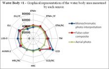
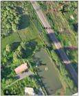
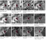
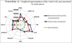
The application of orbital sensors to identify and delineate water bodies was evaluated in this study. Reference aerial photos were used to measure the surface area of three water bodies in São Gabriel do Oeste, MS, Brazil and assess seven sensors commonly used in environmental studies: ALOS-AVNIR, CBERS 2B-CCD, CBERS 2B-HRC, IRS P6-LISS3, LANDSAT-TM, LANDSAT-ETM+, and LANDSAT-OLI. The images were analyzed with the near infrared (NIR) band, and digital processing techniques including image fusion (spatial enhancement), false-color composition, and pre-processed radiometric correction were applied to some sensors. Image fusion and radiometric correction were applied to three sensors; only color composition was not conducted on the HRC sensor. In all water bodies analyzed, images from the CCD sensor showed the greatest values of imprecision, reaching 192% for Water Body #3 without digital processing. Considering the spectral properties of the NIR band, we expected more precise data from the analyses using this spectral range. However, color composite analyses obtained greater percent precision compared with analyses that only used the NIR band.
Keywords:
Geotechnology; Aerial photos; Remote sensing.
 Thumbnail
 Thumbnail
 Thumbnail
 Thumbnail
 Thumbnail
 Thumbnail
 Thumbnail
 Thumbnail
 Thumbnail


