
ABSTRACT
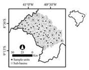
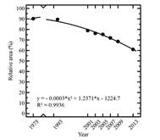
Reliable information on vegetation cover and its dynamics over time is essential for managing life, resources, and supporting policies. Although many related initiatives have been undertaken in Brazil since the 1980s, knowledge about its dry forests is still limited. In this study, we address the drivers of deforestation and their threat to the Brazilian dry forest called Caatinga. We evaluated the land cover dynamics and landscape metrics in the watershed of the Pontal River, as it has become one of the most socially and environmentally important areas in Brazil. The overall process consists of a systematic sampling grid of hydrological samples, where Landsat images (1975 to 2013) combined with the FRAGSTATS package were used to evaluate landscape metrics indices for the Caatinga. Data showed that the relative area (RA) decreased from 90.25% to 60.98% over the 38-year period, while fragmentation (PD) presented an increasing bias. In addition, the spatial distribution of both indices became more heterogeneous and clustered in the north. We suggest that appropriateness of land for farming was the leading cause of deforestation; rainfall is 112% more intense in the north of the watershed than in the south. Therefore, the northern fauna and flora have been significantly altered and reduced. The relationship between deforestation and time shows an increasing threat. Further studies evaluating these causes are needed to improve our understanding of the vegetation dynamics in this region.
Keywords:
Caatinga; Fragmentation; Landscape; Semiarid; Remote Sensing
 Thumbnail
 Thumbnail
 Thumbnail
 Thumbnail
 Thumbnail
 Thumbnail


