ABSTRACT.
Sphenophorus levis has become a major pest of sugarcane plantations in Brazil, causing significant losses in productivity. Few studies have been conducted on the spatial distribution of this pest in the field, which is essential for the development of sampling plans. We aimed to characterize the spatial distribution of S. levis in sugarcane, defining a reliable, practical and feasible sampling plan, as well as generating application maps for production areas, allowing for comparison of the consumption of inputs in a conventional system with site-specific application. The study was conducted in areas around Piracicaba, Brazil. First, we conducted sampling to evaluate the best sampling density to characterize the spatial dependence. The results showed that the procedure in which the evaluators entered every 20 rows of sugarcane and sampled every 20 m was sufficient to characterize the spatial dependence. In separate areas, the sampling was performed similarly to the previous step, and after generating the application maps, insecticide was applied on a site-specific basis. Even using the more strict control level defined by the producer, there was considerable saving for the pesticide used. In the two fields, the percentage of the infestation-free area was 56.1 and 80.7%.
Keywords:
geostatistics, site-specific application; precision agriculture; entomology; soil pests; sugarcane weevil.
RESUMO.
Sphenophorus levis tem se tornado uma praga importante na cultura da cana-de-açúcar, causando perdas expressivas na produtividade. São raros os estudos sobre a distribuição espacial desta praga, e tais estudos são imprescindíveis para o desenvolvimento de planos de amostragem. O objetivo deste trabalho foi caracterizar a distribuição espacial de S. levis definindo um plano de amostragem confiável, prático e viável, assim como gerar mapas de aplicação localizada para poder intervir em áreas de produção, possibilitando comparar o consumo de insumo de uma aplicação convencional com uma aplicação localizada. O estudo se desenrolou em áreas na região de Piracicaba, Brasil. Primeiramente foi realizada uma amostragem para avaliar a melhor densidade amostral para caracterizar a dependência espacial da praga. Os resultados indicaram que onde os avaliadores entravam a cada 20 fileiras de cana e faziam uma amostragem a cada 20 m foi suficiente para caracterizar a dependência espacial. Em outras áreas foi realizado a amostragem seguindo o padrão das avalições prévias e foram gerados os mapas para aplicação localizada de inseticida. Mesmo utilizando o nível de controle mais conservador, houve uma considerável redução na quantidade de defensivo aplicado, a porcentagem de área sem a infestação da praga foi 56,1 e 80,7%.
Palavras-chave:
geoestatistica; aplicação localizada; agricultura de precisão; entomologia, praga de solo.
Introduction
The area cultivated with sugarcane harvested for sugar-ethanol activity in the 2013/14 crop season was estimated to total approximately 8.8 million hectares. São Paulo State is Brazil's largest producer, accounting for 51.7% (4.6 million hectares) of the local sugarcane production (Conselho Nacional de Abastecimento [CONAB], 2012Conselho Nacional de Abastecimento [CONAB]. (2012). Acompanhamento da safra brasileira: Cana-de-açúcar safra 2012/2013. Companhia Nacional de abastecimento. Retrieved on Apr 14, 2014, from http://www.conab.gov. br/OlalaCMS/uploads/arquivos/14_04_10_09_00_57_boletim_cana_portugues_-_4o_lev_-_13
http://www.conab.gov. br/OlalaCMS/upload...
).
Goebel and Sallam (2011Goebel, F. R., & Sallam, N. (2011). New pest threats for sugarcane in the new bioeconomy and how to manage them. Current Opinion in Environmental Sustainability, 3(1-2), 81-89.) reported the importance of the expansion of sugarcane plantations for biofuel in the world and its relation with pests of this crop, mainly the arthropod pests that cause significant damage to all stages and parts of the plants. In Brazil, the expansion of sugarcane plantations favors the increase of many pests, such as the sugarcane weevil (Sphenophorus levis Vaurie), an important and limiting pest, which requires control methods that are effective and less polluting (Polanczyk, Almeida, Padilla, & Alves, 2004Polanczyk, R. A., Almeida, L. C., Padulla, L., & Alves, S. B. (2004). Pests of sugar cane x alternative control methods. Revista Biotecnologia Ciência e Desenvolvimento7(33), 14-17.). It is considered a primary sugarcane pest because of the direct damage that its larvae cause to stem tissues, mainly in the dry season (June to August), causing the death of ratoons and consequent gaps in regrowth, thereby increasing the incidence of invasive plants that compete with the crop. In some cases, a drastic reduction in productivity and longevity of the sugarcane crop may occur (Dinardo-Miranda et al., 2006Dinardo-Miranda, L. L., Fracasso, J. V., Cabral, S. B., Valério, W., Gonçalves, R. D., & Beltrame, J. A. (2006). Efficiency of insecticides applied in ratoon sugar cane for the control of Sphenophorus levis. STAB24(5), 38-41.).
Studies on the spatial distribution of this pest in the field are essential for the development of sampling plans, aiming at its application in integrated pest management programs. When insects are not distributed randomly in the field, there is spatial correlation between sampled points and, in this case, geostatistics is the tool best suited to study populations, as it allows for quantifying the spatial dependence among the samples collected in the field and uses this dependency for the construction of maps (Liebhold, Rossi, & Kemp, 1993Liebhold, A. M., Rossi, R. E., & Kemp, W. P. (1993). Geostatistic and geographic information system in applied insect ecology. Annual Review of Entomology38, 303-327.; Ellsbeury et al., 1998Ellsbeury, M. M., Woodson, W. D., Clay, S. A., Malo, D., Schumacher, J., Clay, D. E., & Carlson, C. G. (1998). Geostatistical characterization of spatial distribution of adult corn rootworm (Coleoptera: Chrysomelidae) emergence. Environmental Entomology27(4), 910-917.; Helden (2010Helden, M. (2010). Spatial and temporal dynamics of arthropods in arable fields. In E.-C., Oerke, R., Gerhards, G., Menz, & R. A. Sikora, (Eds.), Precision Crop Protection - the challenge and use of heterogeneity (p. 51-61). New York, NY: Springer.) reported the importance of characterizing pest distributions to be able to manage pests site-specifically and emphasized that this concept is clearly not yet common among farmers.
The basic tool of geostatistics is the semivariogram, which relates the distance between pairs of samples with statistical semi-variance (variation between pairs) for all possible pairs at each suggested distance (Ellsbeury et al., 1998Ellsbeury, M. M., Woodson, W. D., Clay, S. A., Malo, D., Schumacher, J., Clay, D. E., & Carlson, C. G. (1998). Geostatistical characterization of spatial distribution of adult corn rootworm (Coleoptera: Chrysomelidae) emergence. Environmental Entomology27(4), 910-917.). Because studies of this nature are scarce in the literature, our aim is to characterize the spatial distribution of S. levis in sugarcane crops and define a reliable, practical and feasible sampling plan. We also aimed to construct site-specific application (SSA) maps for a production area, allowing for comparing the consumption of inputs in conventional and localized applications.
Material and methods
To determine the best sampling density to characterize the spatial distribution of the pest, we created scenarios evaluating different sampling densities to identify the behavior of the pest spatial dependence, aiming to determine the best sampling strategy.
To construct a sampling grid that provided reliable data, we adopted two areas of approximately
17.0 ha each. In these areas, we collected circa 70 samples ha-1. Both areas belonged to the same farm, with central coordinates of 22° 34' 30"S and 47° 30'46"W and cultivated with the SP90-1638 variety. The soil is characterized as Hapludox (LVd) and under a production environment B, according to the classification proposed by Prado et al. (2008Prado, H., Pádua Junior, A. L., Garcia, J. C., Moraes, J. F. L., Carvalho, J. P., & Donzeli, P. L. (2008). Solos e ambientes de produção. In L. L. Dinardo-Miranda, A. C. M., Vasconcelos, & M. G. A. Landell, (Eds.), Cana-de-açúcar (p. 179-204). Campinas, SP: IAC.). The areas were planted on January 25, 2006, with 1.5 m spacing, and the mechanized harvesting of the 2010/11 crop occurred from October 22 to 30, 2010.
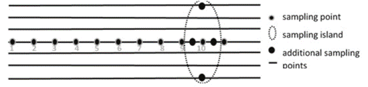
The sampling of the first area was performed on November 19, 2010 and in the second area, between December 1 and 12, 2010. For the sampling of the two areas, a procedure was followed where surveyors were guided by sugarcane rows to be sampled (every 10 rows) and the distance between points was 10 m. Furthermore, we developed sampling islands for every 10 points. Each island was composed of four additional points allocated 5 m before and 5 m after the main point in relation to the walking sense of the surveyor, three rows to the right (4.5 m) and three rows to the left of the central point (Figure 1).
We used a data collector integrated with a GNSS Receiver (Global Navigation Satellite System), working in coarse acquisition (C/A) code at 1.0 Hz (Honeywell, São Paulo, Brazil) and a georeferenced sampling software program developed by the sugarcane mill owner.
In the sampling, we visually assessed the total number of ratoons (TR), ratoons attacked by the pest (AR), larvae (LA), pupae (PP) and adults (AD) related to the insect stages of growth. In addition, the total biological form (BF) composed by LA + PP + AD, percentage of attacked ratoons (%AR) and index (IND) that refers to the pest occurrence were assessed. The %AR was obtained from the relation between AR and TR and multiplied by 100. The IND, however, expresses the places where there was pest incidence (BF + AR), receiving, thus, a value of 1 (one), and areas in which pests were not identified were given a value 0 (zero).

After the field survey was conducted, we created five sample scenarios with different densities (Figure 2) to evaluate the data obtained from the two areas using the software Trackmaker PRO (Geo Studio Tecnologia, Belo Horizonte, Minas Gerais State). Scenario 1 (C1), corresponded to the original sampling where we collected approximately 70 samples ha-1; in scenario 2 (C2), we removed the four additional points corresponding to the islands (50 samples ha-1); in scenario 3 (C3), we removed the points referring to the sampling island and the distance between each point in the sugarcane row became every 20 m (25 samples ha-1); in scenario 4 (C4), we removed the points referring to the islands, the points in the sugarcane row were spaced every 20 m and the distance between sugarcane rows to be sampled was 20 rows, rather than 10 (14 samples ha-1); in scenario 5 (C5), we removed the points referring to the islands, the points in the sugarcane row were spaced every 40 m and the distance between the sampled rows was 20 rows (7 samples ha-1).

Sampling points in area 1 (a) and area 2 (b) with the different sample densities (scenarios C1 to C5).
For each variable of each sampling scenario, we performed geostatistical data analysis, and for construction of the semivariograms, we used the VESPER 1.6 software (Minasny et al., 2002Minasny, B., Mcbratney, A. B., & Whelan, B. M. (2002). Vesper version 1.6. Australian Centre for Precision Agriculture, The University of Sydney. Retrieved on Apr. 10, 2013, from http://www.sydney.edu.au/ agriculture/pal/software/download_vesper.shtml.
http://www.sydney.edu.au/ agriculture/pa...
). After adjusting the model to semivariograms for variables that presented spatial dependence, we estimated values in non-sampled sites using point kriging with 2.0 m pixels, and for the construction of the maps, we used the Global Mapper software (Blue Marble Geographics, Gardiner, USA).
For the analysis of the spatial dependency index (SPI) and classification of the spatial dependence degree, we used the calculation of the SPI expressed as a ratio between the nugget effect (C0) and the sill (C0+C1), [C0/(C0+C1)], where semivariograms that exhibit a nugget effect smaller than or equal to 25% are considered as having strong spatial dependency; between 25 and 75%, medium and greater than 75%, the spatial dependency is considered weak (Cambardella et al., 1994Cambardella, C. A., Moorman, T. B., Parkin, T. B., Karlen, D. L., Novak, J. M., Turco, R. F., & Konopka, A. E. (1994). Field-scale variability of soil properties in central Iowa soils. Soil Science Society of America Journal58(5), 1501-1511.).
After determining the best sampling system, we collected samples in the two production areas (3 and 4) from another farm (22º 36' 48'' S, 47º 29' 12'' W) to perform the SSA of the insecticide. The two areas were cultivated with the sugarcane variety CTC4 in a soil characterized as Hapludox (LVd) under B environment production. Planting occurred on February 2, 2008, with 1.5 m spacing, and the mechanized harvesting of the 2011/12 crop occurred from September 22 to 25, 2011.
On this farm, the sampling was performed on October 11, 2011, and we used the pattern in scenario 4 (C4). We also performed the geostatistical analysis for the variable that best represented the spatial pest dependence (AR) with the same criteria and features of the previous phase.
To construct the maps, we tested severity levels from 0.5 AR to 0.2 AR, and at the end, we used the more stringent control level (0.2 AR) proposed by the sugarcane mill owner of the farm. The product used in the application was a contact-intake systemic insecticide, belonging to the chemical group of neonicotinoid and pyrethroid, with suspension concentrate formulation type. Thus, in places where the damage level was equal to or greater than 0.2 AR, the area received the insecticide at 100 L suspension ha-1 and the dose of the commercial product Engeo Pleno (Syngenta Proteção de Cultivos Ltda, São Paulo, São Paulo State) was 2.00 L ha-1. In areas where the damage level was lower than 0.2 AR, the suspension volume to be applied was 0 L ha-1, i.e., the product was not applied in these areas.
To perform the SSA, an insecticide sprayer was equipped with a flow controller and an integrated GNSS receiver. The equipment consisted of a machine that cuts the soil on the sugarcane ratoons using two cutting discs, and between the discs, there was a pendant with a spray nozzle H1/4U-SS0004 (TeeJet, Wheaton, IL, USA) that applies the product at approximately 0.1 m below ground, cutting and applying the product in three rows at a time.
We used a VCOM 5.6 (Verion Agricultura, Guarulhos, São Paulo State) to control the flow and perform the SSA, which acts on the electrical command valves of the sprayer to control the flow and volume of suspension applied. We used a GNSS Receiver model Smart-AG (Novatel, Calgary, Canada), which operates at 5.0 Hz frequency of data acquisition and has an internal algorithm to improve positioning precision and accuracy, with accuracy of 0.15 m between passes of up to 15 minutes and accuracy of 1.2 m, according to the manufacturer.
To perform the SSA, the map was inserted into the machine via USB memory, and the computer activated the solenoid valve only in the spots where insecticide application was necessary. The GNSS informed the instant position of the machine, the controller correlated this position with the geo-referenced map and inserted into the computer and, thus, the equipment applied the insecticide cutting the ratoons at 0.1 m depth, only where the damage level was greater than 0.2 AR (infestation spots), as established on the recommendation map. In addition, the system ensured the recommended dose (100 L ha-1) through the compensation flow caused by variations in the forward speed.
Results and discussion
Table 1 shows the parameters of semivariograms from areas 1 and 2 for each variable of the different sampling scenarios generated to evaluate which scenario best represents the pest spatial distribution. The semivariogram analyses indicate that in area 1, only the variable PP did not present spatial dependence in any of the scenarios studied. This fact can be related to the pupal period, which is shorter among all developmental stages of the pest. Under laboratory conditions, this pupal period may last 5-13 days, with an average of 10.5 days (Degaspari, Botelho, Almeida, & Castilho, 1987Degaspari, N., Botelho, P. S., Almeida, L. C., & Castilho, H. J. (1987). Biology of Sphenophorus levis Vaurie, 1978 (Coleoptera: Curculionidae) on artificial diet and in the field. Pesquisa Agropecuária Brasileira22(6), 553-558.).
We observed that in area 1 and area 2, sampling scenario 5 presented the highest incidence of the nugget effect for the studied variables. Among the seven variables studied in this scenario, only AR and IND showed spatial dependence in area 1. This fact may be related to a reduction in the number of points used to generate the semivariograms, because in this scenario, we used only 122 points, which corresponds to a sampling of approximately 7.0 points ha-1, indicating that this sampling density was not sufficient to characterize the spatial dependence of most variables.
In area 1, we observe that the sampling in scenario 4 presented the smallest SPI for variables that showed dependence, except for AD. In this scenario, except for AD and IND, the variables exhibited a strong spatial dependence, i.e., smaller than 25% (Cambardella et al., 1994Cambardella, C. A., Moorman, T. B., Parkin, T. B., Karlen, D. L., Novak, J. M., Turco, R. F., & Konopka, A. E. (1994). Field-scale variability of soil properties in central Iowa soils. Soil Science Society of America Journal58(5), 1501-1511.).
We observed that in area 2, only variables AR and LA showed medium or strong degrees of dependence in scenarios 1 to 4. In addition, we observed that scenario 4 had the smallest SPI (except for PP and AD) in relation to the variables studied in area 2.
The assessment conducted in the two areas showed that the variables directly related to the pest (LA, PP, AD and BF) are variables of difficult analysis of spatial dependence. In area 1, the variable PP displayed the nugget effect in all scenarios. In addition, LA and BF also presented the nugget effect in scenario 3.
In area 2, the variable PP exhibited the pure nugget effect in scenarios 3 to 5, and AD presented dependency only in denser sampling (scenario 1). The occurrence of the nugget effect shows that the variable distribution in the field was random or the distance between sampling points was too great to allow the detection of spatial dependence.
The occurrence of the pure nugget effect in studies on insects is rather common, and it is mainly because spatial dependence occurs on a spatial scale smaller than the sampling scale often adopted (Liebhold et al., 1993Liebhold, A. M., Rossi, R. E., & Kemp, W. P. (1993). Geostatistic and geographic information system in applied insect ecology. Annual Review of Entomology38, 303-327.). Another aspect to be considered is the fact that many times, the sampling is performed based on roaming living organisms that favor the occurrence of the nugget effect. In addition, the pest biological cycle can directly affect the studied variables; therefore, it is critical to take into account the time when the sampling was performed in the field.
On the other hand, the variables related to pest attack (AR and %AR) and index (AR + BF) are more constant to determine the spatial dependence, once they showed dependence in most areas and scenarios studied. For the variable AR only sampling scenario 5 of area 2 showed no spatial dependence, and variable %AR presented pure nugget effect only in scenario 5 for areas 1 and 2. Any damage caused to ratoon attacked is permanent and immobile, facilitating the identification of clusters and the characterization of the spatial dependence of the pest.
In all assessments and sampling scenarios, the variable AR presented at least moderate spatial dependence (except in area 2, scenario 5) and, in some situations, a strong degree of spatial dependence (scenario 4, areas 1 and 2); therefore, this variable was more likely to represent the pest occurrence. In addition, this variable showed, in most cases, strong correlation with the most important variables in the decision-making process for pest control (Table 2). LA and adult insects are targets of control measures, BF expresses all living organisms related to the pest (LA + PP + AR), IND relates to any presence of the living pest or its damage, and %AR relates directly to the degree of pest attack on ratoons.
Parameters of semivariograms of assessment variables measured in 2010, referring to areas 1 and 2.
In areas 1 and 2, we observed that sampling scenario 4 (14 samples ha-1) presented the best results in relation to the sampling pattern to represent spatial dependence of the pest, because this scenario has the lowest sampling density for characterizing the spatial dependence of some aspects related to the pest and the damage they caused.
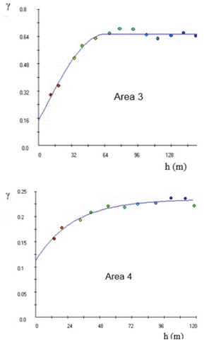
Figure 3 shows the semivariograms of the AR variable, referring to areas 3 and 4 of scenario 4. The model of the adjusted semivariogram of area 3 was spherical and that of area 4 was exponential.
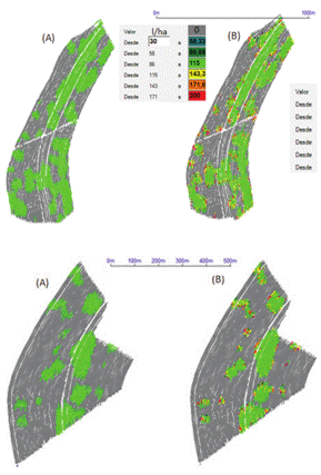
After analyzing the semivariograms, application maps were generated using a control level 0.2 AR. Figure 4 shows the maps generated for areas 3 and 4.
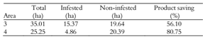
We observe that the regions considered infested (in red) were considerably impacted, particularly in area 4, where there was a reduction above 80% for product use that would be used if the application was performed in the conventional way or over the total area (Table 3).
Figure 5 shows the recommendation maps and post-application. We can observe that the application controller performed its function once the map of recommendation was similar to the application map.
In this type of field investigation, it is difficult to develop a control for treatment's comparison, but using data from the sugarcane mill, it is possible to evaluate the effects of the interventions. The data available from fields 3 and 4 show that in 2011 they produced 93.4 ton ha-1 of cane. In 2012, after receiving the site-specific insect control and vinasse as an extra fertilizing management practice, those two fields produced 125.8 ton ha-1 and the adjacent areas, which received only conventional control, produced 85.7 and 77.0 ton ha-1 in the same years, respectively. This result suggests that the site-specific insect control was efficient and insects did not limit the yield gain of approximately 32 ton ha-1 on the treated areas.
The results of the study show that the sampling plan that best represents the pest was scenario 4, where a sampling density of approximately 14 points ha-1 was adopted. We observe that even in adopting a much denser sampling density, with approximately 70 points ha-1, there were no significant gains regarding SPI decrease. When the sampling density was reduced to 7 points ha-1, virtually all variables presented the nugget effect, not allowing characterization of spatial dependence.


Thus, to perform the georeferenced sampling of Sphenophorus levis, it is recommended to sample approximately 14 points ha-1, and surveyors should follow a routine sampling a row of cane in, at most, with spacing between the points up to 20 m. The variable that best represented the pest for the generation of application maps was attacked ratoons (AR).

Map of the theoretical dose or recommendation map (a) and real dose map or post-application map (b) in areas 3 and 4.
To perform the SSA of the insecticide, it is recommended that the equipment have a flow controller connected to a GNSS receiver that accepts the insertion of georeferenced maps. In addition, the equipment should not cut the sugarcane ratoons in the regions where the pesticide is not applied because the fermentation process of sugarcane without the insecticide presence may favor the infestation of areas that were not previously infested by the pest.
Regarding the control level, each production unit should evaluate the method that presents the best cost/benefit ratio due to some variables, such as crop age, infestation level, pesticide availability, pesticide and application cost. In this study, we observe that even by adopting more stringent control levels, there was considerable product savings, ensuring greater profitability to the user and considerable reduction of chemical applied.
Conclusion
The sampling system used in scenario 4, with approximately 14 samples ha-1, where the points in the sugarcane row were spaced every 20 m and every 20 rows of sugarcane, was adequate to characterize the spatial variability of the pest. The variable that best represented the spatial dependence of Sphenophorus levis was the number of attacked ratoons (AR) by the pest. Even using the more stringent control level, we observed considerable savings for the product used in SSA, confirming the potential use of this technique in integrated pest management systems.
Acknowledgements
The authors wish to thank Verion Agriculture for allowing the use of the controller in the application and the technical team from Usina Iracema for the collaboration to obtain the data used in this study. This work was partially supported by CNPq Grant 305479/2013-0.
References
- Cambardella, C. A., Moorman, T. B., Parkin, T. B., Karlen, D. L., Novak, J. M., Turco, R. F., & Konopka, A. E. (1994). Field-scale variability of soil properties in central Iowa soils. Soil Science Society of America Journal58(5), 1501-1511.
- Conselho Nacional de Abastecimento [CONAB]. (2012). Acompanhamento da safra brasileira: Cana-de-açúcar safra 2012/2013. Companhia Nacional de abastecimento. Retrieved on Apr 14, 2014, from http://www.conab.gov. br/OlalaCMS/uploads/arquivos/14_04_10_09_00_57_boletim_cana_portugues_-_4o_lev_-_13
» http://www.conab.gov. br/OlalaCMS/uploads/arquivos/14_04_10_09_00_57_boletim_cana_portugues_-_4o_lev_-_13 - Degaspari, N., Botelho, P. S., Almeida, L. C., & Castilho, H. J. (1987). Biology of Sphenophorus levis Vaurie, 1978 (Coleoptera: Curculionidae) on artificial diet and in the field. Pesquisa Agropecuária Brasileira22(6), 553-558.
- Dinardo-Miranda, L. L., Fracasso, J. V., Cabral, S. B., Valério, W., Gonçalves, R. D., & Beltrame, J. A. (2006). Efficiency of insecticides applied in ratoon sugar cane for the control of Sphenophorus levis STAB24(5), 38-41.
- Ellsbeury, M. M., Woodson, W. D., Clay, S. A., Malo, D., Schumacher, J., Clay, D. E., & Carlson, C. G. (1998). Geostatistical characterization of spatial distribution of adult corn rootworm (Coleoptera: Chrysomelidae) emergence. Environmental Entomology27(4), 910-917.
- Goebel, F. R., & Sallam, N. (2011). New pest threats for sugarcane in the new bioeconomy and how to manage them. Current Opinion in Environmental Sustainability, 3(1-2), 81-89.
- Helden, M. (2010). Spatial and temporal dynamics of arthropods in arable fields. In E.-C., Oerke, R., Gerhards, G., Menz, & R. A. Sikora, (Eds.), Precision Crop Protection - the challenge and use of heterogeneity (p. 51-61). New York, NY: Springer.
- Liebhold, A. M., Rossi, R. E., & Kemp, W. P. (1993). Geostatistic and geographic information system in applied insect ecology. Annual Review of Entomology38, 303-327.
- Minasny, B., Mcbratney, A. B., & Whelan, B. M. (2002). Vesper version 1.6. Australian Centre for Precision Agriculture, The University of Sydney. Retrieved on Apr. 10, 2013, from http://www.sydney.edu.au/ agriculture/pal/software/download_vesper.shtml
» http://www.sydney.edu.au/ agriculture/pal/software/download_vesper.shtml - Polanczyk, R. A., Almeida, L. C., Padulla, L., & Alves, S. B. (2004). Pests of sugar cane x alternative control methods. Revista Biotecnologia Ciência e Desenvolvimento7(33), 14-17.
- Prado, H., Pádua Junior, A. L., Garcia, J. C., Moraes, J. F. L., Carvalho, J. P., & Donzeli, P. L. (2008). Solos e ambientes de produção. In L. L. Dinardo-Miranda, A. C. M., Vasconcelos, & M. G. A. Landell, (Eds.), Cana-de-açúcar (p. 179-204). Campinas, SP: IAC.
Publication Dates
-
Publication in this collection
Sept 2016
History
-
Received
21 July 2015 -
Accepted
18 Dec 2015