
Abstract:
Cartographic data represents the main and basic component of a Spatial Data Infrastructure. SDI, in turn, has the role of supporting, with strategic information, the most diverse political and economic actions, in the management and planning of public actions. Thus, this work aims, initially, to present an overview of cartography in Brazil through the analysis of the evolution of topographic mapping coverage in the country. For each of the main scales used, a coverage map was created. The analyzes reflect three different periods (until 1997, between 1998 and 2007, after 2008) in order to relate how and to what degree, the creation of Brazilian National SDI (in 2008) had an impact on the mapping production in the country. Given the current panorama, as a final objective, this paper aims at to present proposals to leverage the coverage of this reference data. One of them is the use of new data sources such as Volunteered Geographic Information, especially in areas with outdated mapping or without mapping, as has already been used in some countries. Another proposition is to share the responsibility of mapping through partnerships with other levels of government, which would result the decentralization and the optimization of cartographic production.
Keywords:
INDE; SDI; VGI; Authoritative mapping; Mapping coverage; Geospatial information
Resumo:
Os dados cartográficos representam o componente básico e principal de uma Infraestrutura de Dados Espaciais. As IDEs, por sua vez, têm o papel de apoiar, com informações estratégicas, as mais diversas ações políticas e econômicas, na gestão e no planejamento das ações públicas. Assim, este trabalho visa, inicialmente, apresentar uma visão geral da cartografia no Brasil por meio da análise da evolução da cobertura cartográfica topográfica no país. Para cada uma das principais escalas utilizadas, foi criado um mapa de cobertura. As análises refletem três períodos distintos (até 1997, entre 1998 e 2007, após 2008) para relacionar como e em que grau a criação da Infraestrutura Nacional de Dados Espaciais (em 2008) impactou a produção cartográfica no Brasil. Diante do panorama atual, como objetivo final, o presente artigo visa apresentar propostas para aumentar a cobertura desses dados de referência. Uma delas é a utilização de novas fontes de dados, como as Informações Geográficas Voluntárias, principalmente em áreas com mapeamento desatualizado ou sem mapeamento, como já vem sendo utilizado em alguns países. Outra proposta é compartilhar a responsabilidade do mapeamento por meio de parcerias com outros níveis de governo, o que resultaria na descentralização e na otimização da produção cartográfica.
Palavras-chave:
INDE; IDE; Mapeamento colaborativo; Mapeamento de referência; Cobertura do mapeamento; Informação geoespacial
1. Introduction
The importance of maps and geospatial information as a tool of public management, territorial planning, education, sustainable development, national sovereignty and social policies is unquestionable. Topographic maps maintain their status of authority among cartographic products, as Kent and Hopfstock (2018Kent, A. J. and Hopfstock, A. 2018. Topographic Mapping: Past, Present and Future. The Cartographic Journal, 55(4), pp.305-08.) emphasize. According to the United Nations Committee of Experts on Global Geospatial Information Management - UN-GGIM (2015)UN-GGIM - United Committee of Experts on Global Geospatial Information Management. 2015. Future trends in geospatial information management: the five to ten year vision. 2nd ed. Available at:<Available at:http://ggim.un.org/knowledgebase/Attachment1759.aspx?AttachmentType=1 > [Accessed 19 August 2018].
http://ggim.un.org/knowledgebase/Attachm...
, funding in geospatial information is worthwhile and will generate returns beyond the investment made in it. Spatial Data Infrastructures (SDIs) represent the set of technologies, policies and institutional arrangements that provide management, availability and access to spatial data. Thus, SDIs play a key role in the integration of these components of a framework designed to treat and manage geospatial information in several aspects, from design to use and distribution.
A recent study has shown that since SDI’s are constituted by interrelated components, they must be considered together (Borba 2017Borba, R. L. R. 2017. Ecossistema para infraestrutura de dados espaciais híbrida, coproduzida, colaborativa, convergente e compartilhável. PhD thesis. Universidade Federal do Rio de Janeiro.). Among them, the users, who should be the main focus of any modern SDI, and the information (data and metadata) which consists in its fundamental framework and constitutes its database. In this sense, effectively available, complete, updated and standardized topographic charts, at different scales are essential for an efficient implementation of an SDI (Sluter and Camboim 2009Sluter, C. R. and Camboim, S. P. 2009. The National Topographic Mapping as an Indispensable Database for a Brazilian National Spatial Data Infrastructure (NSDI). In: Proceedings of the XXIV International Cartographic Conference. Santiago, Chile, 15-21 Nov 2009.). Moreover, researches ensure that a catalog of geospatial metadata is fundamental for the search and identification of information about the spatial data set, and so it is one of the essential components of an SDI, and can be considered its core (Silva 2015Silva, R. L. 2015. Metadados Geoespaciais: O Coração de uma IDE. In: Anais do XVII Simpósio Brasileiro de Sensoriamento Remoto - SBSR. João Pessoa, Brazil, 25-29 Apr 2015.).
In Brazil, The National SDI (in Portuguese, “Infraestrutura Nacional de Dados Espaciais” or INDE) is the legal framework for the management and treatment of geospatial information. Established by a presidential decree in November, 2008 (Brasil 2008Brasil. 2008. Decreto nº 6.666, de 27 nov 2008. Institui, no âmbito do Poder Executivo Federal, a Infraestrutura Nacional de Dados Espaciais (INDE), e dá outras providências. Available at: <Available at: http://www.planalto.gov.br/ccivil_03/_Ato2007-2010/2008/Decreto/D6666.htm > [Accessed 20 August 2018].
http://www.planalto.gov.br/ccivil_03/_At...
), at that moment, it represented the possibility of a new paradigm for the cartographic production in the country in particular, which would imply in actions to stimulate the increase of mapping coverage, optimized use of public budgets - avoiding, for example, duplicity of efforts - and in the adoption of better documented workflows. Because of its importance, after a decade of the INDE’s implementation, many analyses and evaluations can be carried out, as well as considerations and other issues about this period. Thus, among the various components of this infrastructure, the available data are addressed in more detail in this work. Its main objectives are: (a.) to analyze the evolution of the topographic authoritative mapping coverage and (b.) to contribute with proposals of future challenges.
This paper presents a historical overview of topographic mapping in Brazil and analyzes the topographic authoritative mapping coverage in three distinct periods: 1) a time prior to the implementation of INDE, before 1997; 2) from 1998 to 2007; 3) its evolution along ten years, from 2008 to 2018, both in terms of coverage and in the different scales used. This analysis was carried out based on the information contained in the INDE’s metadata catalog service as well as in the national mapping agencies index maps.
Drawing from the analysis carried out, it becomes evident that there is a great demand for updating or new mapping according to the modern standards established by CONCAR, acronym in Portuguese for National Commission of Cartography. This is a fundamental problem for the fulfillment of one of INDE’s main objectives (CONCAR 2010CONCAR - Comissão Nacional de Cartografia. 2010. Plano de Ação para Implantação da Infraestrutura Nacional de Dados Espaciais. Rio de Janeiro.), since without the authoritative mapping it loses its original purpose and will turn into an initiative that will hardly achieve the desired effectiveness.
The understanding of the current situation regarding the availability of authoritative cartographic data is included in the analysis carried in this work. It directs possible planning actions that may contribute to change this reality. In particular, actions to maintain public funding and increase government efforts that may lead INDE to evolve into a higher level of effectiveness.
Finally, this paper aims to contribute to the reduction of the gaps in geospatial information existing in the country by presenting some alternative propositions and future challenges. One of them is the possibility of integrating crowdsourcing data, also known as Volunteered Geographic Information (VGI), into the INDE’s database. This kind of data can be obtained through several platforms such as OpenStreetMap, Google Maps, HERE Map Creator, among others. The OpenStreetMap platform presents more potential at this time because it is the most used worldwide and because it provides the possibility of relating the semantic standard of authoritative maps with the semantic standard of data available in that collaborative platform. It seems clear that this is a source of information that should be increasingly studied due to the great potential of using, crossing and integrating.
2. A brief historical overview about topographic mapping in Brazil
The first mapping actions in Brazil began back in the colonial era (16th century) and extended to the period of the Empire (19th century). These activities were developed especially due to the needs of the Portuguese Crown, originated by the exploratory navigations and those generated by the consequent territorial occupation of the colonized lands. From the independence of Brazil in 1822, until the first half of the twentieth century, other isolated initiatives contributed to the mapping of some regions of the country, and a substantial part of these activities counted on the collaboration of countries such as Austria and Germany (Archela 2007Archela, R. S. 2007. Evolução Histórica da Cartografia no Brasil - Instituições, formação profissional e técnicas cartográficas. Revista Brasileira de Cartografia, 59(03), pp.213-23.).
As cited by Sluter et al. (2018Sluter, C. R. Camboim, S. P. Iescheck, A. L. Pereira, L. B. Castro, M. C. Yamada, M. M. Araújo, V. S. 2018. A proposal for topographic maps symbols for large-scale maps of urban areas in Brazil. The Cartographic Journal , 55(4) pp.362-77.) the Brazilian territory had its first aerophotogrammetric survey performed by the United States Air Force - USAF - from 1942 to 1943, with 1:60,000 scale photographs in the 1:60,000 scale. The availability of this photogrammetric coverage allowed for a cooperative agreement between the Brazilian government and the USAF in the 1970s, which resulted in the mapping of about 60% of the Brazilian land in the 1:50,000 and 1:100,000 scales. This mapping effort meant a great development of the national cartography, which occurred mainly between 1974 and 1985. Santos and Castiglione (2014Santos, C. J. B. and Castiglione, L. H. G. 2014. A atuação do IBGE na evolução da cartografia civil no Brasil. Terra Brasilis (Nova Série), 3.) point out that in just five years, from 1977 to 1982, the Cartography Dynamization Program (PDC) reached about 27% of the country’s total area. Although it was an intense period, such as the 1992 production, which was equal to twice the area of Germany, but in terms of Brazil, this meant only 9% of the territory.
However, it is important to highlight that the cartographers and photogrammetrists who came to Brazil from Austria, Germany, and the United States of America introduced techniques and methods that were developed for the realities of their countries, that is, with differences in several aspects such as cultural and historical evolution, urban and rural landscapes, land use and occupation. Moreover, these approaches were not always suitable for Brazilian urban and natural environments (Sluter et al. 2018Sluter, C. R. Camboim, S. P. Iescheck, A. L. Pereira, L. B. Castro, M. C. Yamada, M. M. Araújo, V. S. 2018. A proposal for topographic maps symbols for large-scale maps of urban areas in Brazil. The Cartographic Journal , 55(4) pp.362-77.).
Furthermore, the standards imported from other countries were, for a long time, restricted to small-scale topographic mapping (1:25,000 - 1:1,000,000 scales). As emphasized by Sluter and Camboim (2009Sluter, C. R. and Camboim, S. P. 2009. The National Topographic Mapping as an Indispensable Database for a Brazilian National Spatial Data Infrastructure (NSDI). In: Proceedings of the XXIV International Cartographic Conference. Santiago, Chile, 15-21 Nov 2009.), in addition to the lack of standards for larger scales, not the entire country is mapped at those larger scales. More critical than that, though is the fact that with the exception of the continuous cartographic base in the 1:250,000 scale, Brazil, has never had a topographic mapping program that included a process for updating official maps. Additionally, the authors point out that the existing Brazilian topographic mapping all derives from photogrammetric surveys. Thus, maps at smaller scales are not produced by cartographic generalization. Consequently, these two authors corroborate Archela’s (2007Archela, R. S. 2007. Evolução Histórica da Cartografia no Brasil - Instituições, formação profissional e técnicas cartográficas. Revista Brasileira de Cartografia, 59(03), pp.213-23.) work in that, due to a number of factors of different natures, there is a cartographic void at various scales and in most of that existing topographic mapping in Brazil is outdated.
The history of cartography in Brazil accompanies the turbulences of national politics and economy, often suffering fragmentation and interruptions in every change of government. From Machado’s (2017Machado, A. A. 2017. Comparação entre o mapeamento de referência do Brasil e da Grã-Bretanha. Academic work. Universidade Federal do Paraná.) perspective, the evolution was slow along the years, but with a trajectory of technological development and increasing performance. Nevertheless, the analysis of national cartography carried out by the two main institutions that share the responsibility for authoritative topographic mapping in Brazil shows that both institutions have actually made efforts to improve this panorama and follow the evolution of the world in terms of technologies and dissemination of geospatial information, in spite of the difficulties described above.
However, despite the difficulties regarding factors of coverage and updating of the mapping, a very favorable aspect of authoritative cartography in Brazil is that it can be accessed by any citizen, on the websites of the producing institutions or on the INDE’s GeoPortal.
Access to all cartographic products under the responsibility of IBGE (Brazilian Institute of Geography and Statistics), as shown in the coverage maps throughout this article, is free of charge, with an open and unrestricted license on its website (IBGE 2020IBGE - Instituto Brasileiro de Geografia e Estatística. 2020. Download - Geociências. Available at:< Available at:https://www.ibge.gov.br/geociencias/downloads-geociencias.html > [Accessed 19 July 2020].
https://www.ibge.gov.br/geociencias/down...
). Regarding the geospatial data produced by DSG (Directorate of Geographic Service - Brazilian Army), access to raster format files is allowed after a registration at its geoportal. On the other hand, products in vector format have greater access restrictions, which become more rigid as the scale of the maps increases, so that, in general, the download of this data is only allowed for government users (DSG 2020DSG - Diretoria de Serviço Geográfico. 2020. Geoportal do Exército Brasileiro - Acesso ao BDGEx. Available at:<Available at:https://bdgex.eb.mil.br/portal/bdgex-1/permissoes-acesso > [Accessed 19 July 2020]
https://bdgex.eb.mil.br/portal/bdgex-1/p...
). Finally, on the INDE’s GeoPortal, geospatial data and its metadata are cataloged, stored and available with free access to users (INDE 2020INDE - Infraestrutura Nacional de Dados Geoespaciais. 2020. O portal brasileiro de dados geoespaciais - SIG BRASIL. Available at:<Available at:https://www.inde.gov.br/ > [Accessed 19 July 2020].
https://www.inde.gov.br/...
).
3. Methodology
To carry out this work, it was sought, in particular, to establish an overview of the fundamental framework of an SDI, which are the authoritative maps. For this purpose, the authoritative topographic mapping in Brazil was characterized regarding the following aspects: the scales of the mapping; the main actors in the production process; effectively mapped areas; and the period of its execution. This characterization was performed from the smallest detail scale (1:250,000) to the one with the greatest detail (1:25,000) among those featuring in the national cartographic system.
Thus, in order to compare the evolution of this most important component in relation to time, and especially in the first decade since the creation of INDE, a picture of the availability of the authoritative maps was made in three periods: the maps produced and available for more than 10 years prior to the implementation of INDE (prior to 1997); those referring to the immediately previous ten years (from 1998 to 2007); and a current panorama, in the year of the INDE’s ten years anniversary (2018), with the data generated as of 2008.
Information about cartographic coverage was obtained from several sources such as: digital index map of Brazil; army geographic database; INDE’s portal and metadata catalog; and compilation of various mapping projects produced in partnerships with other federal or state organizations.
The main objective of the 1:250,000 scale mapping is to serve as a cartographic reference for planning, monitoring and territorial management actions, as well as updating information on the country’s natural resources, as IBGE indicates on its website (IBGE 2017IBGE - Instituto Brasileiro de Geografia e Estatística. 2017. BC250 - Documentação técnica geral. Available at:<Available at:ftp://geoftp.ibge.gov.br/cartas_e_mapas/bases_cartograficas_continuas/bc250/versao2017/informacoes_tecnicas/Documentacao_bc250_v2017.pdf > [Accessed 13 March 2019]
ftp://geoftp.ibge.gov.br/cartas_e_mapas/...
).
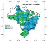
Until 1997, cartography in the 1:250,000 scale was composed by 401 traditional topographical sheets, i.e. printed or PDF format sheets whose mapped area was delimited by a surrounding polygon of 1°30’ longitude by 1° latitude. These sheets were almost all produced in the 1980s, compiled from large scale charts, when existing, or otherwise by aerophotogrammetric processes. This represented coverage of 72.9% of the total number of 550 sheets intended for this scale, as shown in Figure 1.
In 1998, the production of the traditional charts in this scale was discontinued. From 2008 onwards, cartographic representation followed a concept of continuous cartographic base, and mapping became a digital, continuous and integrated product. Therefore, it became more modern and compatible with digital applications and geographical information systems, since its data modeling follows the standards according to the established vector geospatial data structure. Thus, a simplified overview of the current Continuous Cartographic Base in the 1:250,000 scale (known as BC250) is shown in Figure 2. It is the first and only scale of the basic terrestrial mapping covering the whole national territory. In addition, IBGE maintains a permanent updating program of this continuous cartographic base that is made available to the society, free of charge, both in Shapefile format and for use in POSTGIS database.

The other mapping scales constitute the reference bases through cartographic representations of natural and artificial geographic features of the earth’s surface and their respective geographical names (IBGE 2019IBGE- Instituto Brasileiro de Geografia e Estatística. 2019. Folhas topográficas - sobre. Available at:<Available at:https://www.ibge.gov.br/geociencias-novoportal/cartas-e-mapas/folhas-topograficas/15809-folhas-da-carta-do-brasil.html?=&t=saiba-mais > [Accessed 13 March 2019].
https://www.ibge.gov.br/geociencias-novo...
). Thus, the sheets of charts in 1:100,000, 1:50,000 and 1:25,000 scales comprise the authoritative topographic mapping of the country. Due to the size of the country, production capacity and different characteristics of urban occupation, population density and natural conditions, the 1:100,000 and 1:50,000 scales were planned to be complementary, that is, most part of the country has cartographic coverage on one scale or another. Figure 3 shows mapping coverage in the 1:100,000 - 1:25,000 scales according to mapping agency and Figure 4 presents mapping period. The mapping percentage available in each three scales and the percentages referring to the period are shown in Table 1.
Mapping coverage and period of mapping of Brazilian territory by official topographic maps at the 1:100,000-1:25,000 scales.


As previously mentioned, mapping in the 1:100,000 scale had a great advance in the 1970s and 1980s, period of intense development of authoritative mapping in analogical format by aerophotogrammetric processes. In the ten years prior to the INDE’s implementation, production at this scale was insignificant. Since 2008, a great rhythm of production has been resumed, with many sheets being concluded by the Directorate of Geographic Service - DSG (a Brazilian Army technical unit) through the Radiografia da Amazônia Project (Amazon’s Radiography), executed by SAR (Synthetic Aperture Radar) images (Correia et al. 2010Correia, A. H. Rosa, R. A. S. Vieira, P. R. Silva, R. R. 2010. Projeto Radiografia da Amazônia: Metodologia de aerolevantamentos SAR (Bandas X e P) e apoio de campo. In: XXIV Congresso Brasileiro de Cartografia. Aracaju, Brazil, 16-20 May 2010.) and IBGE, which produced continuous cartographic bases (BC) for three States (Espírito Santo, Goiás and Roraima), by extracting features from satellite images.
As in the aforementioned scale, the 1:50,000 scale mapping had most of its development parallel to the 1:100,000 scale, in the 1970s and 1980s, with the production being carried out using the same process. From 1998 to 2007, quantity was quite insignificant. Similarly, as of 2008, there was a resumption of the production of cartography in this scale, in a project developed by the Directorate of Geographic Service in the Radiografia da Amazônia Project.
The 1:25,000 scale mapping has always had a very limited coverage, since the mapping process by aerophotogrammetry is very costly, particularly in this scale. Thus, until 1997 the percentage of coverage in this scale was about 1% in analogical charts. From 1998 to 2007 the production also did not stand out. After 2008, two projects (In the West Region of the State of Bahia, performed by the Directorate of Geographic Service and the continuous cartographic base of the State of Rio de Janeiro, by the IBGE) provided a discrete increase in the coverage, which is currently around 5% of the territory.
Figure 5 presents the quantities of mapping sheets produced by decades and according to the scale.

The merge of the cartographic coverage of the 1:100,000, 1:50,000 and 1:25,000 scales represents a total of 94.2% of the entire national territory. With this scenario, the percentage of area mapped in the last ten years is around 49% of the total mapped area, in the sum of the three scales, according to Figure 6.

It is important to highlight that the sum of the coverage of the three scales presented in Table 1 exceeds 100%. In contrast, Figure 6 shows some areas with no topographic mapping. This situation occurs because some regions have mapping performed on duplicity of scales, thus confirming the existence of the cartographic void.
The difficulty of having a complete, updated and multi-scale reference mapping is certainly not exclusive to Brazil. Other countries with a history and evolution with some degree of similarity face similar situations. Then, in order to draw a parallel with the reality of some countries, information about the general situation of cartography and spatial data infrastructures in developing countries, such as Argentina, Chile, Colombia and India, is presented.
Argentina, whose cartographic activity is the responsibility of the Instituto Geográfico Nacional, has complete coverage only for the 1:250,000 scale, in analogical maps, in a project started in 1997. For the 1:100,000 and 1:50,000 scales it has partial coverage (about 70%) and most of it was produced in the 1980s. From the decade of 2010, Argentina started to produce mapping structured in geographic database aiming at the implantation of a national SDI. Existing data is available free of charge (IGN 2020IGN- Instituto Geográfico Nacional. 2020. Información Geoespacial. Available at: <Available at: https://www.ign.gob.ar/NuestrasActividades/InformacionGeoespacial/Introduccion > [Accessed 19 July 2020].
https://www.ign.gob.ar/NuestrasActividad...
).
In relation to Chile, the cartography is produced by the Instituto Geográfico Militar and the country has an extensive mapping coverage. Chile has complete coverage for mapping on a 1:250,000 scale, produced between the 1980s and 1990s and this material is available on the SDI portal (IDE Chile 2020IDE Chile - Infraestrutura de Datos Geoespaciales. 2020. Geoportal de Chile - Visor de Mapas. Available at:<Available at:http://www.geoportal.cl/visorgeoportal/ > [Accessed 19 July 2020].
http://www.geoportal.cl/visorgeoportal/...
). Regarding the larger scales, the country has mapped 97% of its territory on the 1:50,000 scale, produced between 1970 and 2015, which is available in vector format and 11% of its extension on the 1:25,000 scale, produced more than 35 years ago and updated between 2012 and 2018. However, it is important to note that, with the exception of the 1:250,000 scale, the other geospatial data are sold by the institution (IGM 2020IGM - Instituto Geográfico Militar. 2020. Venta de Productos IGM. Available at: <Available at: https://www.igm.cl/ventasweb.php?venta2=A > [Accessed 19 July 2020].
https://www.igm.cl/ventasweb.php?venta2=...
).
Colombia, since 2020, began to provide access to all geospatial data produced by the organization responsible for official cartography in the country, Instituto Geográfico Augustín Codazzi, in a digital, free and open license. Thus, in its geoportal it is possible to download vector data, in 1:25,000, 1:100,000 and 1:500,000 scales, whose bases were updated in 2017, 2018 and 2016, respectively, and cover the whole country (IGAC 2020IGAC - Instituto Geográfico Agustín Codazzi. 2020. Geoportal - Datos Abiertos. Available at: <Available at: https://geoportal.igac.gov.co/contenido/datos-abiertos-cartografia-y-geografia > [Accessed 21 July 2020].
https://geoportal.igac.gov.co/contenido/...
).
India, an emerging economy country that integrates the BRICS with Brazil, also has an extensive territory. Its national mapping agency, Survey of India, has the Open Series Map project, which makes available in vector format, free of charge, all of its topographic mapping on the 1:50,000 scale, which comprises more than 90% of its territory (SOI 2020SOI - Survey of India. 2020. Availability of Open Series Maps. Available at: <Available at: http://www.surveyofindia.gov.in/pages/display/189-download-open-series-maps(osm) > [Accessed 19 July 2020].
http://www.surveyofindia.gov.in/pages/di...
).
4. Discussions
One of the objectives of this paper was to discuss the evolution of the mapping coverage, by comparing its situation in three moments: ten years before (until 1997) the implementation of the INDE (Brazilian National Spatial Data Infrastructure); the moment of its implementation (2008); and the present moment (until the end of 2018).
The construction of this scenario was not such a simple task. The cataloging of the metadata of the cartographic collection presents several inconsistencies in filling, such as incomplete data as well as dates and other divergent information.
The findings of this study shown that over the last ten years there has been a significant increase in geospatial information and, in fact, it was considerably higher than in the previous period. However, due to the great size of the Brazilian territory and the reduced funding for this activity for decades, a period of great scarcity of mapping was experienced, which caused what we can call a huge cartographic gap.
From the retrospectives carried out, it was possible to identify in Figure 5 an analogous situation between the 1:50,000 and 1:100,000 scales, which had a great evolution in the 1970s and 1980s, followed by a period of stagnation over the next two decades. Only after 2008, mapping in these scales was resumed, thus presenting considerable advances in the last ten years. In contrast, mapping in the 1:25,000 scale has always been quite restricted and only in the last decade has its development been consolidated. Even so, the total area of the country mapped at this scale is still reduced and does not reach 6% of the territory.
It is necessary to emphasize that until the end of the 90s mapping activities were based basically on photogrammetric processes, which, in spite of being a very costly process, it was the only technique available and economically viable With new alternative technologies for mapping - such as airborne radar images - being developed at lower costs, with better resolution imagery, solving the technical difficulties related to the Amazon region, it was possible to carry out projects in the last decade which culminated in the increase of mapping coverage.
A finding of this work is that although the amount of geospatial information generated in the last decade has been considered satisfactory, it is perceived that there is a need to maintain or increase this rhythm, since the demand for updated, complete and various scales mapping is very large. As is the case of new trends or technologies supported by geospatial information, such as smart cities, drones, public policies, drones, scientific researches etc. Thus, it is fundamental that governmental funding in this area be maintained or even expanded.
As mentioned in the introduction, the availability of authoritative map data is a key element for the Spatial Data Infrastructures. This statement can also be verified with the INDE data access indexes. The increase of available data in the INDE has, consequently, increased the number of accesses and downloads of information. This finding allows us to understand and justify the existence of a SDI, first because the data is fundamental and has to be available, and secondly because it has been increasingly attending to user’s needs.
In this same way, it is important to emphasize that the production of geospatial information has a very high cost. Because of this, an irrefutable way to justify the high funding required in this area, is to make this data increasingly transparent, accessible and shared, allowing for the broad generation of knowledge and support for governance actions. Thus, it is important that Brazil seeks to approach positive examples from countries like Colombia and India, as presented in this paper.
An important factor of advanced production is related to changes in production platforms. In the past, analogical processes slowed down the workflow and mapping activities was segmented into smaller areas. Currently, based on a more modern concept, mapping projects are carried out in a GIS environment; data is stored in powerful databanks; available information has associated metadata and cartographic features are represented on continuous bases. All of these characteristics make mapping processes faster and more reliable and therefore less susceptible to errors.
The evolution of the mapping percentage in the last decade was not only due to the implementation of the NSDI, but also to a combination of aforementioned factors such as modernization of cartographic techniques, technological evolution and diversification, lower cost processes, in addition to greater involvement of mapping agencies in partnerships dedicated to the generation of geoinformation. The existence of a SDI by itself does not lead to increased cartographic production, which is due to a combination and evolution of technical factors as well as the sum of efforts between the organizations involved. For instance, organizations responsible for mapping or for providing a certain category of information making their data available updated and standardized in the INDE. This kind of decentralization represented a huge step in mapping process, by sharing responsibilities, so that each of several organizations have become the providers of the information on the subjects in which they are experts. In this sense, it is fundamental that the number of organizations that join INDE increases and that their participation takes place effectively, in order to facilitate the obtaining of updated and more complete data.
Given the current situation of the authoritative map coverage in Brazil, it is suggested to planning the integration with new data sources. The use of VGI can be a great advance, especially for areas with outdated information or without mapping. Bortolini et al. (2018Bortolini, E. Silva, L. S. L. Machado, A. A. Paiva, C. A. Camboim, S. P. 2018. Potenciais categorias de informações geográficas do mapeamento colaborativo para o Oficial. In: X Colóquio Brasileiro de Ciências Geodésicas. Curitiba, Brazil, 6-8 Jun 2018. ) explored the potentialities and constraints that contribute to the degree of use possibility associated with each category of geographic information. Machado (2020Machado, A. A. 2020. Compatibilização semântica entre o modelo de dados do OpenStreetMap e a Especificação Técnica para Estruturação de Dados Geoespaciais Vetoriais (ET-EDGV). PhD thesis. Universidade Federal do Paraná.) proposed the semantic compatibility between the conceptual models of the OSM and the Brazilian authoritative cartography. Other researchers (Graser, Straub and Dragaschnig 2013Graser, A. Straub, M. and Dragaschnig, M. 2013. Towards an Open Source Analysis Toolbox for Street Network Comparison: Indicators, Tools and Results of a Comparison of OSM and the Official Austrian Reference Graph. Transactions in Gis, 18(4), pp.510-26.; Dorn, Törnros and Zipf 2015Dorn, H. Törnros, T. and Zipf, A. 2015. Quality Evaluation of VGI Using Authoritative Data - A comparison with land use data in Southern Germany. ISPRS International Journal of Geoinformation, 4(3), pp.1657-71.; Brovelli et al. 2016Brovelli, M. A. Minghini, M. Molinari, M. E. Zamboni, G. 2016. Positional accuracy assessment of the OpenStreetMap buildings layer through automatic homologous pairs detection: the method and a case study. In: XXIII ISPRS Congress. Prague, Czech Republic , 12-19 Jul 2016.) have studied and discussed this topic and the authors have demonstrated that this type of information is reliable and compatible for integrated use with the authoritative mapping, and that it should be used, especially to fill a gap in areas where cartography is outdated or non-existent. Olteanu-Raymond et al. (2017)Olteanu-Raimond, A-M. Laakso, M. Antoniou, V. Fonte, C. C. Fonseca, A. Grus, M. Harding, J. Kellenberger, T. Minghini, M. Skopeliti, A. 2017. VGI in National Mapping Agencies: Experiences and Recommendations. In: G. Foody, L. See, S. Fritz, P. Mooney, A.-M. Olteanu-Raimond, C. C. Fonte, V. Antoniou, eds. 2017. Mapping and the Citizen Sensor. Londres: Ubiquity Press, 2017. pp.299-326. point out several countries that use collaborative information, integrating it in some way with authoritarian mapping, such as France, Finland and Germany (new data collection), Sweden (place names), Netherland and Switzerland (change detection).
Another important proposition deals with the mapping partnerships with Brazilian States and Municipalities. Over the last few years, some state or municipal Secretariats of Planning and of Environment have promoted mapping actions to support their governmental activities. Thus, these secretariats have sought partnerships with the national mapping agencies, which have allowed a significant increase in cartographic data availability. In the last 10 years, at least 15 partnerships of this type were carried out in Brazil, in addition to 8 independent projects by state governments. Similar situations are successfully experienced in other countries such as Australia (Geoscience Australia 2018Geoscience Australia. 2018. Chapter Seven: Geoscience Australia Report On Performance. Available at:<Available at:https://publications.industry.gov.au/publications/annualreport201718/geoscience-australia/chapter-seven-geoscience-australia-report-on-performance/ > [Accessed 06 April 2020].
https://publications.industry.gov.au/pub...
) and USA (USGS 2020aUSGS - United States Geological Survey. 2020a. National Geospatial Program - Partners. Available at:<Available at:https://www.usgs.gov/core-science-systems/national-geospatial-program/partners > [Accessed 06 April 2020].
https://www.usgs.gov/core-science-system...
; USGS 2020bUSGS - United States Geological Survey. 2020b. Federal Agency Partnerships. Available at: <Available at: https://www.usgs.gov/core-science-systems/ngp/user-engagement-office/agency-partner > [Accessed 06 April 2020].
https://www.usgs.gov/core-science-system...
) which establish partnerships with organizations at different government levels to support mapping actions.
5. Conclusions
This work also aimed at presenting propositions to leverage the authoritative cartographic data coverage. Nowadays, there is availability of increasingly abundant geospatial data, coming from multiple sources including Volunteered Geographic Information. On the other hand, the availability of data in a country as extensive as Brazil occurs heterogeneously, both in terms of quantity and quality. Generalization, multi-scale applications and flexible mapping products should be exhaustively investigated. These concepts need to be researched, since they consider two important approaches such as big data and dynamic representations.
As seen in the discussion section, due to the constant difficulties of the federal government in supporting continuous mapping projects, this kind of partnership or the own initiatives of the state governments have been presented as excellent alternatives, which have provided the production of updated cartographic bases. This scenario has contributed to solve the problem of lack of progress in cartographic production and it is very important that it be continued.
As future challenges, it is necessary to consider how to adapt the INDE to a new perspective, whose conception is closer to the demands of the users. So, it is very relevant that the users, as other fundamental component of an SDI, realize that their effective participation must be part of INDE’s evolution. Moreover, current trends show that user-centric design is a continuous and non-return way for SDIs.
A noteworthy limitation of this work is the lack of other pieces of research related to the subject. As the INDE is a recently created initiative, the 10-year anniversary of its creation and the preparation of a commemorative event for this remarkable date provided the idea of establishing a panorama of its current situation and making the present analyses in order to evaluate the effectiveness of its implementation.
Finally, it is important to remark that the implementation of the INDE contributed to the possibility of great advances in terms of mapping coverage of the Brazilian territory, which is highlighted by the analyzes presented in this work. However, this article presents elements to understand the current reality of cartography in Brazil, which has been experiencing incomplete and outdated mapping for decades, a fact that implies difficulties and losses in actions related to the development of the country, such as in the planning and management of several sectors and activities.
ACKNOWLEDGMENT
We are especially grateful to Ana Cristina da Rocha Bérenger Resende for the complete revision of the English version.
REFERENCES
- Archela, R. S. 2007. Evolução Histórica da Cartografia no Brasil - Instituições, formação profissional e técnicas cartográficas. Revista Brasileira de Cartografia, 59(03), pp.213-23.
- Borba, R. L. R. 2017. Ecossistema para infraestrutura de dados espaciais híbrida, coproduzida, colaborativa, convergente e compartilhável PhD thesis. Universidade Federal do Rio de Janeiro.
- Bortolini, E. Silva, L. S. L. Machado, A. A. Paiva, C. A. Camboim, S. P. 2018. Potenciais categorias de informações geográficas do mapeamento colaborativo para o Oficial. In: X Colóquio Brasileiro de Ciências Geodésicas Curitiba, Brazil, 6-8 Jun 2018.
- Brasil. 2008. Decreto nº 6.666, de 27 nov 2008. Institui, no âmbito do Poder Executivo Federal, a Infraestrutura Nacional de Dados Espaciais (INDE), e dá outras providências Available at: <Available at: http://www.planalto.gov.br/ccivil_03/_Ato2007-2010/2008/Decreto/D6666.htm > [Accessed 20 August 2018].
» http://www.planalto.gov.br/ccivil_03/_Ato2007-2010/2008/Decreto/D6666.htm - Brovelli, M. A. Minghini, M. Molinari, M. E. Zamboni, G. 2016. Positional accuracy assessment of the OpenStreetMap buildings layer through automatic homologous pairs detection: the method and a case study. In: XXIII ISPRS Congress Prague, Czech Republic , 12-19 Jul 2016.
- CONCAR - Comissão Nacional de Cartografia. 2010. Plano de Ação para Implantação da Infraestrutura Nacional de Dados Espaciais Rio de Janeiro.
- Correia, A. H. Rosa, R. A. S. Vieira, P. R. Silva, R. R. 2010. Projeto Radiografia da Amazônia: Metodologia de aerolevantamentos SAR (Bandas X e P) e apoio de campo. In: XXIV Congresso Brasileiro de Cartografia Aracaju, Brazil, 16-20 May 2010.
- Dorn, H. Törnros, T. and Zipf, A. 2015. Quality Evaluation of VGI Using Authoritative Data - A comparison with land use data in Southern Germany. ISPRS International Journal of Geoinformation, 4(3), pp.1657-71.
- DSG - Diretoria de Serviço Geográfico. 2020. Geoportal do Exército Brasileiro - Acesso ao BDGEx. Available at:<Available at:https://bdgex.eb.mil.br/portal/bdgex-1/permissoes-acesso > [Accessed 19 July 2020]
» https://bdgex.eb.mil.br/portal/bdgex-1/permissoes-acesso - Geoscience Australia. 2018. Chapter Seven: Geoscience Australia Report On Performance. Available at:<Available at:https://publications.industry.gov.au/publications/annualreport201718/geoscience-australia/chapter-seven-geoscience-australia-report-on-performance/ > [Accessed 06 April 2020].
» https://publications.industry.gov.au/publications/annualreport201718/geoscience-australia/chapter-seven-geoscience-australia-report-on-performance/ - Graser, A. Straub, M. and Dragaschnig, M. 2013. Towards an Open Source Analysis Toolbox for Street Network Comparison: Indicators, Tools and Results of a Comparison of OSM and the Official Austrian Reference Graph. Transactions in Gis, 18(4), pp.510-26.
- IBGE - Instituto Brasileiro de Geografia e Estatística. 2017. BC250 - Documentação técnica geral. Available at:<Available at:ftp://geoftp.ibge.gov.br/cartas_e_mapas/bases_cartograficas_continuas/bc250/versao2017/informacoes_tecnicas/Documentacao_bc250_v2017.pdf > [Accessed 13 March 2019]
» ftp://geoftp.ibge.gov.br/cartas_e_mapas/bases_cartograficas_continuas/bc250/versao2017/informacoes_tecnicas/Documentacao_bc250_v2017.pdf - IBGE- Instituto Brasileiro de Geografia e Estatística. 2019. Folhas topográficas - sobre. Available at:<Available at:https://www.ibge.gov.br/geociencias-novoportal/cartas-e-mapas/folhas-topograficas/15809-folhas-da-carta-do-brasil.html?=&t=saiba-mais > [Accessed 13 March 2019].
» https://www.ibge.gov.br/geociencias-novoportal/cartas-e-mapas/folhas-topograficas/15809-folhas-da-carta-do-brasil.html?=&t=saiba-mais - IBGE - Instituto Brasileiro de Geografia e Estatística. 2020. Download - Geociências. Available at:< Available at:https://www.ibge.gov.br/geociencias/downloads-geociencias.html > [Accessed 19 July 2020].
» https://www.ibge.gov.br/geociencias/downloads-geociencias.html - IDE Chile - Infraestrutura de Datos Geoespaciales. 2020. Geoportal de Chile - Visor de Mapas. Available at:<Available at:http://www.geoportal.cl/visorgeoportal/ > [Accessed 19 July 2020].
» http://www.geoportal.cl/visorgeoportal/ - IGAC - Instituto Geográfico Agustín Codazzi. 2020. Geoportal - Datos Abiertos. Available at: <Available at: https://geoportal.igac.gov.co/contenido/datos-abiertos-cartografia-y-geografia > [Accessed 21 July 2020].
» https://geoportal.igac.gov.co/contenido/datos-abiertos-cartografia-y-geografia - IGM - Instituto Geográfico Militar. 2020. Venta de Productos IGM. Available at: <Available at: https://www.igm.cl/ventasweb.php?venta2=A > [Accessed 19 July 2020].
» https://www.igm.cl/ventasweb.php?venta2=A - IGN- Instituto Geográfico Nacional. 2020. Información Geoespacial. Available at: <Available at: https://www.ign.gob.ar/NuestrasActividades/InformacionGeoespacial/Introduccion > [Accessed 19 July 2020].
» https://www.ign.gob.ar/NuestrasActividades/InformacionGeoespacial/Introduccion - INDE - Infraestrutura Nacional de Dados Geoespaciais. 2020. O portal brasileiro de dados geoespaciais - SIG BRASIL. Available at:<Available at:https://www.inde.gov.br/ > [Accessed 19 July 2020].
» https://www.inde.gov.br/ - Kent, A. J. and Hopfstock, A. 2018. Topographic Mapping: Past, Present and Future. The Cartographic Journal, 55(4), pp.305-08.
- Machado, A. A. 2017. Comparação entre o mapeamento de referência do Brasil e da Grã-Bretanha Academic work. Universidade Federal do Paraná.
- Machado, A. A. 2020. Compatibilização semântica entre o modelo de dados do OpenStreetMap e a Especificação Técnica para Estruturação de Dados Geoespaciais Vetoriais (ET-EDGV) PhD thesis. Universidade Federal do Paraná.
- Olteanu-Raimond, A-M. Laakso, M. Antoniou, V. Fonte, C. C. Fonseca, A. Grus, M. Harding, J. Kellenberger, T. Minghini, M. Skopeliti, A. 2017. VGI in National Mapping Agencies: Experiences and Recommendations. In: G. Foody, L. See, S. Fritz, P. Mooney, A.-M. Olteanu-Raimond, C. C. Fonte, V. Antoniou, eds. 2017. Mapping and the Citizen Sensor Londres: Ubiquity Press, 2017. pp.299-326.
- Santos, C. J. B. and Castiglione, L. H. G. 2014. A atuação do IBGE na evolução da cartografia civil no Brasil. Terra Brasilis (Nova Série), 3.
- Silva, R. L. 2015. Metadados Geoespaciais: O Coração de uma IDE. In: Anais do XVII Simpósio Brasileiro de Sensoriamento Remoto - SBSR João Pessoa, Brazil, 25-29 Apr 2015.
- Sluter, C. R. and Camboim, S. P. 2009. The National Topographic Mapping as an Indispensable Database for a Brazilian National Spatial Data Infrastructure (NSDI). In: Proceedings of the XXIV International Cartographic Conference Santiago, Chile, 15-21 Nov 2009.
- Sluter, C. R. Camboim, S. P. Iescheck, A. L. Pereira, L. B. Castro, M. C. Yamada, M. M. Araújo, V. S. 2018. A proposal for topographic maps symbols for large-scale maps of urban areas in Brazil. The Cartographic Journal , 55(4) pp.362-77.
- SOI - Survey of India. 2020. Availability of Open Series Maps. Available at: <Available at: http://www.surveyofindia.gov.in/pages/display/189-download-open-series-maps(osm) > [Accessed 19 July 2020].
» http://www.surveyofindia.gov.in/pages/display/189-download-open-series-maps(osm) - UN-GGIM - United Committee of Experts on Global Geospatial Information Management. 2015. Future trends in geospatial information management: the five to ten year vision. 2nd ed. Available at:<Available at:http://ggim.un.org/knowledgebase/Attachment1759.aspx?AttachmentType=1 > [Accessed 19 August 2018].
» http://ggim.un.org/knowledgebase/Attachment1759.aspx?AttachmentType=1 - USGS - United States Geological Survey. 2020a. National Geospatial Program - Partners. Available at:<Available at:https://www.usgs.gov/core-science-systems/national-geospatial-program/partners > [Accessed 06 April 2020].
» https://www.usgs.gov/core-science-systems/national-geospatial-program/partners - USGS - United States Geological Survey. 2020b. Federal Agency Partnerships. Available at: <Available at: https://www.usgs.gov/core-science-systems/ngp/user-engagement-office/agency-partner > [Accessed 06 April 2020].
» https://www.usgs.gov/core-science-systems/ngp/user-engagement-office/agency-partner
Publication Dates
-
Publication in this collection
20 Nov 2020 -
Date of issue
2020
History
-
Received
15 Apr 2020 -
Accepted
26 Sept 2020


