
Abstract
Mine closure is the set of all activities that follow the end of the productive phase of a mine, characterizing itself as the process of returning an area transformed by mining into a new condition of sustainability, considering the potential future and the best possible reclamation of the area impacted. However, such an understanding was not conceivable during the Colonial Period, a time when gold mining took place in the Ouro Preto Hill, among others, and nearly 200 years after the end of the gold rush, negative and positive impacts are revealed by the human interaction and the urban occupation on those mined areas. Through both geographic information data of eighteenth-century mining traces and a socioeconomic study involving six tourist gold mines, this article describes how overcoming paradigms involving underground mines have resulted in business opportunities, setting a success example of Mine Closure and future use of the area, showing an alternative way to handle the current abandoned mines.
Keywords:
mine closure; gold mines; eighteenth-century; gold rush; Ouro Preto
1. Introduction
The region of Ouro Preto was the scene of an intense gold rush in the 18th century and testimonies of this activity can still be found today. These testimonies, located in the Ouro Preto Hill, have great archaeological and tourist potential. The 18th Century Gold Rush occurred throughout the flanks of the Mariana Anticline and its hinge zone (Ouro Preto Hill, Antônio Pereira Hill and Passagem de Mariana Hill, respectively). The Ouro Preto Hill, object of this article, is the Southwestern flank of the Mariana Anticline and the mine remnants are spread over an inhabited part of the town, public and private properties. Currently, 8 underground mines are part of the Ouro Preto tourist itinerary. However, this is an insignificant figure considering the estimated more than 300 abandoned underground mines that can be found in the region (Laccourt, 1937LACCOURT, F. Ouro Preto and Mariana gold deposits. Revista Mineração e Metalurgia, v. July-August, p. 87-95, 1937.; Lima and Miranda, 1996LIMA, H. M., MIRANDA J. F. Os 300 anos da atividade garimpeira na região de Ouro Preto e Mariana, Minas Gerais. Revista da Escola de Engenharia da UFRGS, v. 17, p. 12-18, 1996.; Sobreira and Fonseca, 2001SOBREIRA, F. G., FONSECA, M. A. Impactos físicos e sociais de antigas atividades de mineração em Ouro Preto, Brasil. Revista Geotecnia, v. 92 , p. 5-28, 2001.; Sobreira et al., 2005SOBREIRA, F. G., LIMA, H. M., DOMINGUES, A. L., VICENTIM, F. V. Alterações paisagísticas pela extração do ouro do século XVIII no distrito de Passagem de Mariana (município de Mariana, MG). In: SIMPÓSIO BRASILEIRO SOBRE O TECNÓGENO, 1. Anais... Guarapari (ES): ABEQUA, 2005.).
The discovery of this gold-rich region dates back to the end of the 17th century, when Bandeirantes conducted expeditions in Brazilian territory, and found alluvial gold in the region of Ouro Preto, initiating the so called gold rush. First extracted from the mineralized alluviums, gold was later extracted from riverbanks and hillsides, and in a final phase gold was extracted from the quartz veins in underground mines. By the end of the 18th century a sharp drop in gold production was experienced as a consequence of the predatory mining installed (Eschwege, 1944ESCHWEGE, W. L. V. Pluto Brasiliensis. São Paulo: Compainha Editora Nacional, 1944. v. 1.).
After almost 200 years of the gold mining, Ouro Preto preserves the marks of the mining activities developed in riverbeds, on the hills or underground (Lima et al. 2017LIMA, H. M., BARBOSA, V. S. B., LAUDARES, S. Georreferenciamento e construção de um banco de dados geográficos dos sítios arqueológicos da mineração do ouro do século XVIII na região de Ouro Preto, Minas Gerais. In: SIMPÓSIO NACIONAL DE GEOGRAFIA URBANA, 15. Anais... Salvador (BA): SIMPURB, 2017.; Sobreira and Fonseca, 2001SOBREIRA, F. G., FONSECA, M. A. Impactos físicos e sociais de antigas atividades de mineração em Ouro Preto, Brasil. Revista Geotecnia, v. 92 , p. 5-28, 2001.). Today, such testimonies are confused with the landscape and pass unnoticed by most people. Along the 5 km stretch of part of the Serra de Ouro Preto, numerous remnants of gold mining can be found. These include underground and open pit mines, aqueducts, water dams, gold mud dams, locally called mundéos, and shafts for ventilation, miners access and ore extraction. In addition, these orphan mine sites comprise an interesting area of study for Mine Closure issues including post-mining use, mine site reclamation, and the environmental and socioeconomic aspects in the long-term.
These ancient gold mines resulted in negative and positive environmental and socioeconomic impacts in Ouro Preto. The negatives are mainly related to areas of subsidence, abandoned structures (such as shafts that impose risk to the people and domestic animals) and contamination of water or alteration of the water quality. On the other hand, the touristic exploration of abandoned underground mines purposes has been a beneficial economic activity for the current landowners, where these mines are located, being today a considerable source of employment and income for the population.
This article describes the status quo of the cataloging process of these mining sites and their characteristics in the Ouro Preto Hill noting that the solution given to the underground mines by some locals reveals that the current negative impacts can be reasonably mitigated considering all current mine closure precepts.
2. Methodology
2.1 Cataloguing process of the vestiges of the mining of century XVIII
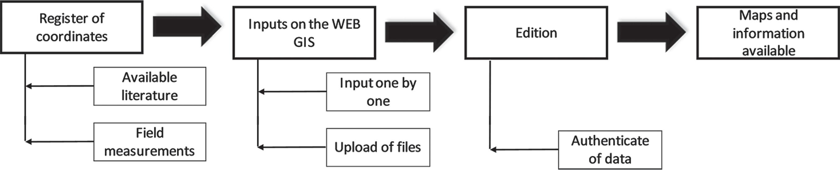
The cataloguing process of mining traces of the eighteenth century is not recent: several academic studies have sought to characterize the ancient mines and locate them in space as a way of understanding the old local mining process and its consequences for society and the environment. In the current database, the oldest records date back to Laccourt (1937)LACCOURT, F. Ouro Preto and Mariana gold deposits. Revista Mineração e Metalurgia, v. July-August, p. 87-95, 1937., followed by Lima et al. (1995)LIMA, H. M., CRISPI, M., CAVALCANTI, J.A. Mapeamento das antigas minas de Ouro Preto: subsídios para implantação de sítios históricos. In: ENCONTRO LUSO-BRASILEIRO DE REABILITAÇÃO URBANA DOS SÍTIOS HISTÓRICOS, 1. Anais... Lisboa (Portugal): luso-Brasil patrimônio, 1995. and Cavalcanti et al. (1996)CAVALCANTI, J. A., CRISPI, M., LIMA, H. M. Ocupação urbana em áreas de mineração do período colonial, Ouro Preto, Minas Gerais: impactos físicos e socioculturais. In: CONGRESSO BRASILEIRO DE GEOLOGIA, 39. Anais... Salvador (BA): CBG, 1996., and year after year more information has been generated and made available. Figure 1 presents the methodological flowchart followed by the authors in order to collect new data regarding the ancient gold mines.
The organization of geographic information in a single environment is, therefore, a natural consequence of the numerous records on ancient mines, ruins, wells, aqueducts and ore reservoirs (known as mundéos). Currently, the Web Geographic Information System (WebGIS) consists of 176 records, of which 109 correspond to independent entries of underground mines.
In order to maintain consistency between the records, the data, from the field survey or the available literature, are classified and must provide sufficient information to fill out the form of their category, as shown in Tables 1 and 2. In the next step, all records are included in a free geographic information system, such as Google My Maps© or ESRI ArcGIS Online©, which make it possible to view the records on upgraded maps or satellite images, as well as offer functionalities of geoprocessing. That is, thanks to available geotechnology, it is possible to create customized cartographic products, such as the maps presented herein.
The methodology adopted herein is applicable to several areas of public domain that need low-cost analyses of a considerable amount of geographic information. The implementation of economic mappings in cities, universities and other public agencies has become a recurring resource due to the advantageous cost-benefit ratio. A key to its effective implementation is usability (ease of use and adaptability for mobile devices) without the need for extensive training.
The approach to the remnants from the eighteenth-century in Ouro Preto is not unique, as the cataloging process aims to record broad information about them, according to Tables 1 and 2. This information associated with the records are spatialized occurrences that can guide the research of hydrogeology, industrial archeology, risk mitigation, among others. The focus of the current study is to identify the underground mines that are used as a tourist route; that is, as a source of income for the population. Thus, from filters applied to the WebGIS (Type: "Mine entrance" and Current Use: "Tourism"), it is possible to identify the 8 tourist mines located into urban network of Ouro Preto and handle this group as an object of study. The location of these 8 tourist mines near to downtown is unquestionable evidence that urban occupation developed over the old mining areas of the eighteenth-century. This fact is reinforced by new queries to the WebGIS and especially when all the remnants are presented on the satellite images.
2.2 Geoprocessing of the mine sites and ruins
The geographic database displayed on the My Maps (Google My Maps, 2018GOOGLE MY MAPS. Web Geographic Information System of the old mines of Ouro Preto. Available at: <https://drive.google.com/openid=1U5ggzlsWZH0d0tNrV_oiopm3ctA&usp=sharing>. Accessed August 2018.
https://drive.google.com/openid=1U5ggzls...
) or ArcGIS Online (Arcgis Online, 2018ARCGIS ONLINE. Web Geographic Information System of the old mines of Ouro Preto. Available at: <https://arcg.is/08HO5m>. Accessed August 2018.
https://arcg.is/08HO5m...
) is hosted in "cloud computing" and through the web address, it is possible to view the georeferenced points, as well as the form information associated with the record. Database storage capacity, tools available for analysis (such as filters, buffers, area calculations) and information security are limited by the free services offered by the GIS platform.
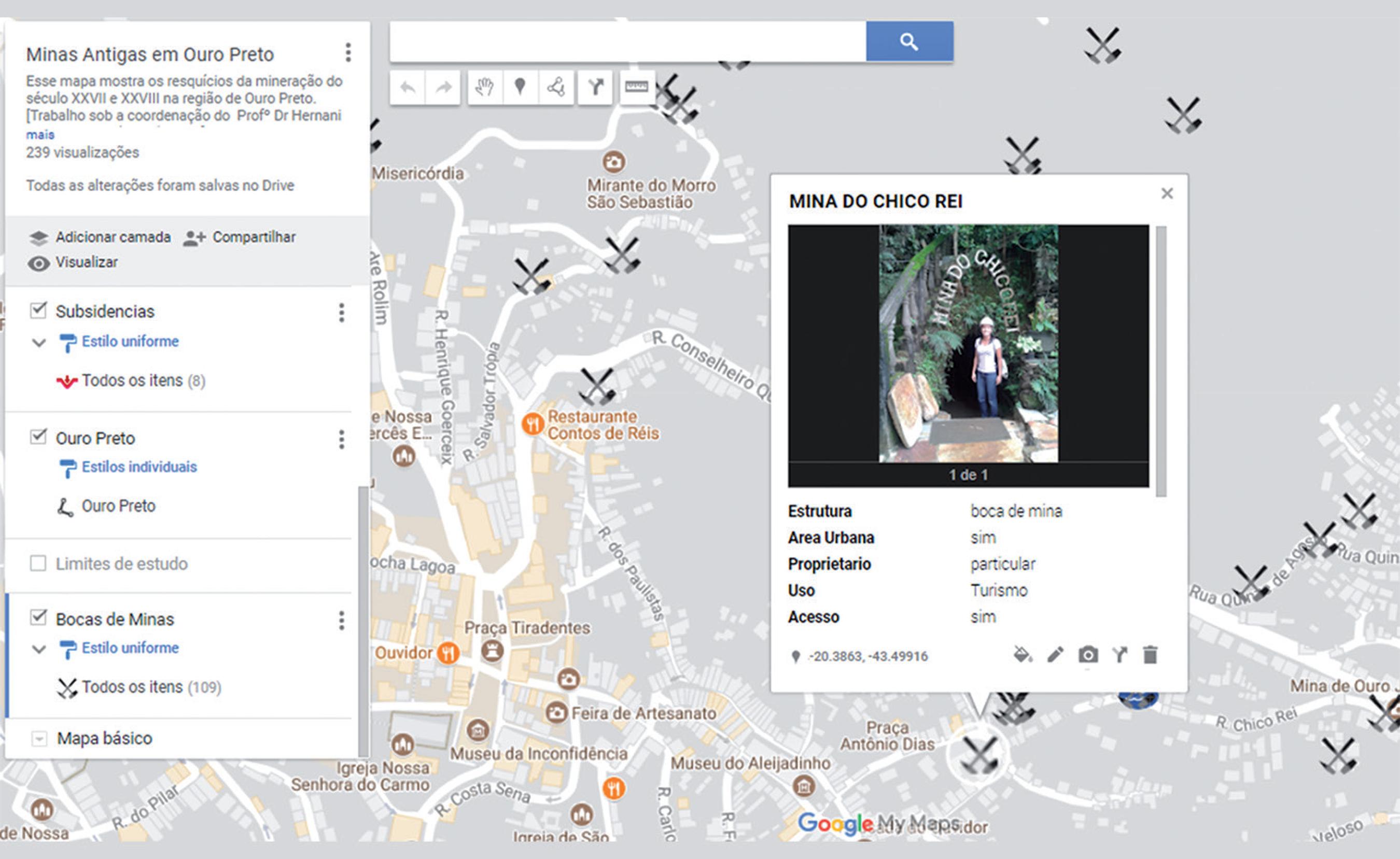
By accessing the electronic address associated to My Maps or ArcGIS Online, all records are displayed on screen, as shown in Figure 2. An information balloon is triggered by a mouse click at the registered point, showing a picture of the location (if any) and features acquired in the field (Figure 3). The research project maintains the records of the old mines both on Google© and ESRI© geographic information system, both free for academic purposes provided the sources are quoted.
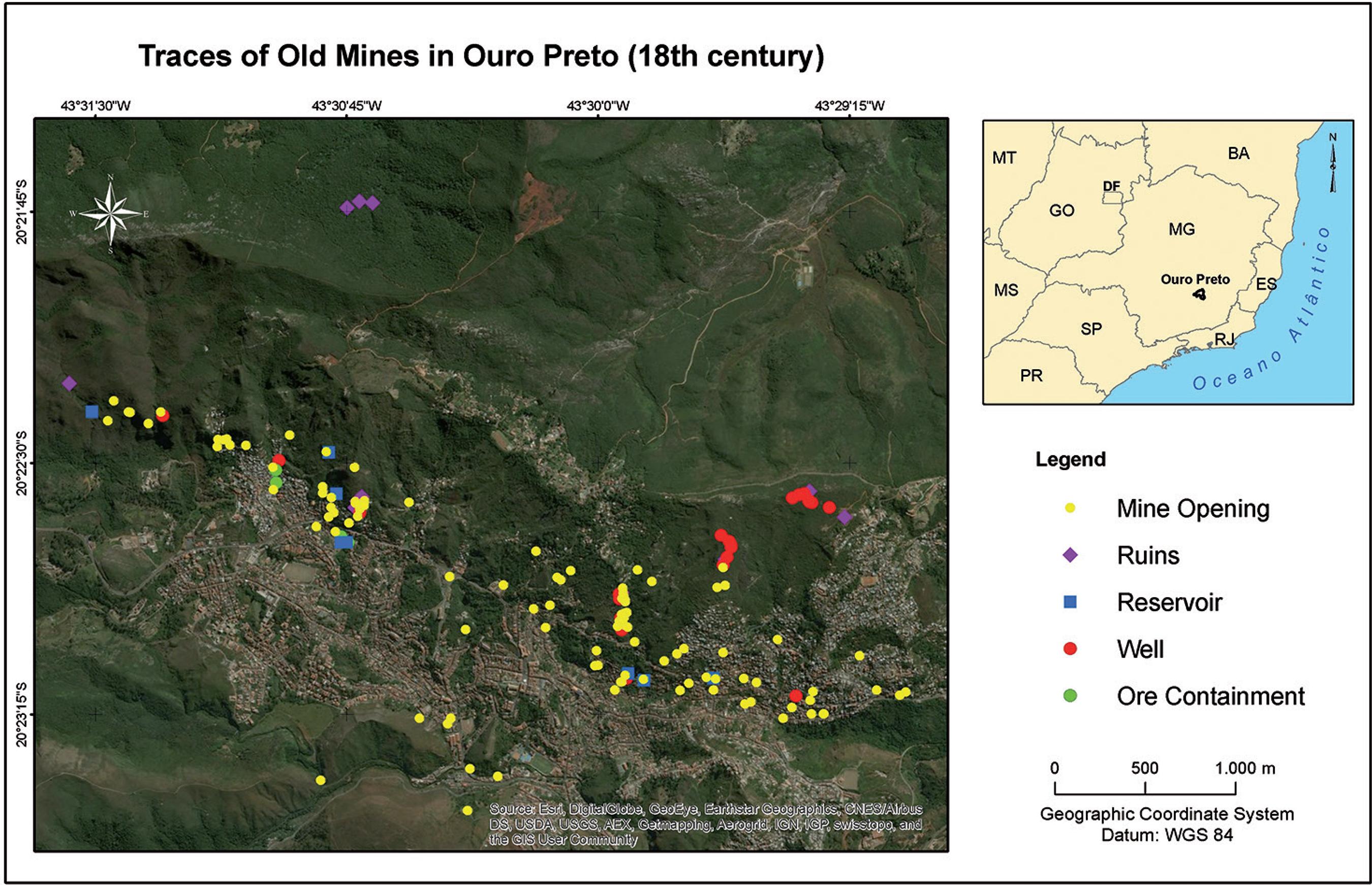
Visualization of the location of part of the 165 records of eighteenth-century mining traces in the Ouro Preto Hill, generated by ArcGIS Online.
Customizing WebGIS is possible because of Application Programming Interfaces (APIs). API is a set of instructions and programming standards for accessing an Internet-based software application. An API resembles software as a service, in the sense that WebGIS designers do not have to start from scratch each time they write a program: features such as coordinate centering on the screen, zoom level, search box, satellite imagery, among others, can be used for the production of digital maps (Laudares and Abreu, 2013LAUDARES, S ., ABREU, J. F. D. Aplicações em sistemas de geovisualização: uma proposta metodológica a partir de componentes “web” genéricos. Belo Horizonte: Pró-Reitoria de Pós-Graduação da PUC-Minas, 2013.).
2.3 The Mine Closure in Ouro Preto
One of the fundamental premises of the Mine Closure is to determine the best possible reclamation of the area impacted by mining to the community that was most affected by the process. Formerly Vila Rica, now the city of Ouro Preto, was declared a World Heritage Site by UNESCO on September 5, 1980, being the first Brazilian Cultural Heritage inscribed on the World Heritage List. Therefore, it is natural to consider mining closure proposals geared to tourism, by establishing a connection with the vocation of the region, making them more attractive, feasible and close to the reality of the citizens of Ouro Preto.
Although only 8 of the 109 underground mines are not a representative sample of the database, they reveal the transformative social potential of using old mines as tourist routes. By private initiatives and with the support of the Mining Engineering and the Geology Departments of the School of Mines at the Federal University of Ouro Preto (UFOP), these mines have been restored and surveyed in order to consolidate themselves as tourist attractions and as the main source of income for those who explore them for a living.
Additionally, the Department of Tourism, Industry and Commerce of Ouro Preto provides a free guide with information about the ancient Gold Mines that can be visited in the region. In its most recent pamphlet "Old Mines: Preserved History", the mines of Santa Rita, Chico Rei, Jeje, Du Veloso and Felipe dos Santos are presented to tourists that visit the town. Generally, such mines are passed from generation to generation of a family since they lie within the limits of a private property.
The main entrances to the sited underground mines are commonly located on private properties, especially in the poor neighborhoods of the city which are on the slopes of the Ouro Preto Hill, a place that has notoriously developed numerous open pit and underground mines. However, such a symbol was easily related to an insignia of regret and torture, an unpleasant memory of the times of the existence of slavery in Brazil, and many residents obstructed the entrances for security reasons or hid them for representing hard times for the black people. Such a paradigm, however, has been overcome, and several holders of underground mine entrances have seen such mines as an economic opportunity. The tourist exploitation of these mines has re-signified the strong stigma of suffering and slave labour resulting from the gold mining in the Brazilian colonial period.
3. Discussion of results
In Ouro Preto, an ancient gold mine does not become a touristic one overnight. As the interest in tourism exploration is relatively recent, the owner of an ancient mine site is the one who owns the mine within the limits of his property and therefore can decide whether or not to invest in a new business.
Once the decision to set up a tourist mine is positive, the owner must secure an operating permit, conditional upon compliance with various requirements imposed by the public prosecutor's office of the town, such as the fire-fighters department certificate of safety of the site for tourism exploration purposes.
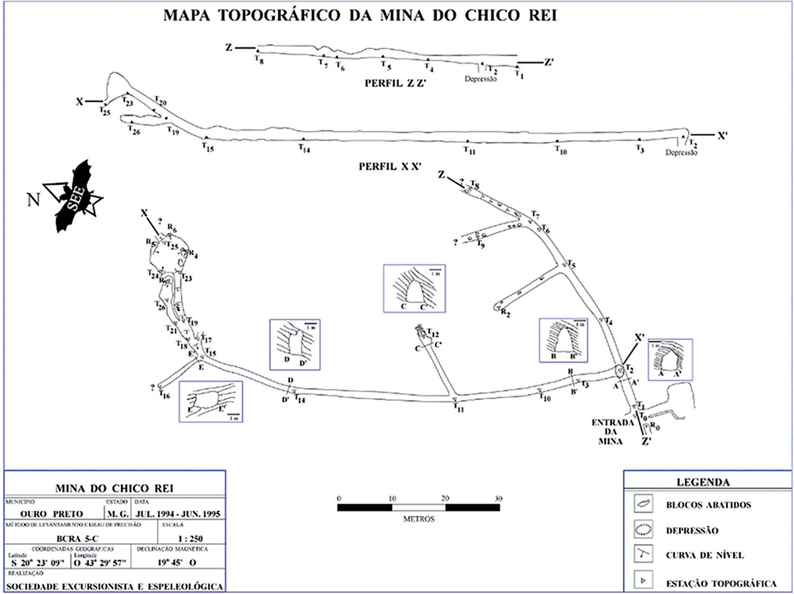
The Mining Engineering Department of UFOP has assisted these mine site owners in preparing the documents and technical reports to obtain the licenses for tourist purposes. A touristic mine must be lit throughout its course; underground openings must be stable and safe, demonstrated by a geomechanical hazard map prepared by a competent person; it must have a topographic map at its portal, fire extinguishers, sufficient signage in areas of instability or drainage and take any other intervention necessary to ensure a safe environment for visitation. The most well-known tourist mines have obtained reports of mine engineers attesting to the stability of the excavations and maps made by the Speleological Society (SEE, 2018SEE. Mine map made by the Speleological Society (Sociedade Excursionista e Espeleológica) of the Federal University of Ouro Preto. Available at: <http://see.ufop.br/>. Accessed on August 2018.
http://see.ufop.br/...
) of the School of Mines of the Federal University of Ouro Preto. Figure 4 shows a map produced by the SEE.
The 8 underground mines classified as tourist in the database are inserted in the urban area of Ouro Preto, as shown in Figure 5. It is interesting to note that part of the city developed over the old mining areas, as shown by the small portion of the identified tourist mines, so it is reasonable to think that there are more underground excavations. Only in this small area to the east of the Du Veloso Mine and west of the Santa Rita Mine, the database records the existence of exactly 81 underground mines, of which 52 are located in public properties in a state of total abandonment (Arcgis Online, 2018ARCGIS ONLINE. Web Geographic Information System of the old mines of Ouro Preto. Available at: <https://arcg.is/08HO5m>. Accessed August 2018.
https://arcg.is/08HO5m...
; Google My Maps, 2018GOOGLE MY MAPS. Web Geographic Information System of the old mines of Ouro Preto. Available at: <https://drive.google.com/openid=1U5ggzlsWZH0d0tNrV_oiopm3ctA&usp=sharing>. Accessed August 2018.
https://drive.google.com/openid=1U5ggzls...
).
Table 3 shows the survey of the average monthly revenues generated by 6 of these tourism enterprises, at current values. Ferraria Mine and Antônio Dias Mine were not part of the socioeconomic study because they are enterprises that are open seasonally for visitors. Even mines with lower billings are characterized as profitable deals for their dealers.
The year of inauguration and the number of direct jobs were raised through an interview addressed to the owner of the mine. The business model of all 6 mines is similar: people work at the reception, guides are prepared to contextualize tourists, mining history is discussed and a visit is made to the underground mine with the owner. Other people work outside the mine, in attracting tourists in more distant places. All listed tourist mines are financially controlled by one or two people.
The number of visits per month was estimated from the Visitor Book kept at the reception of all 6 mines and is voluntarily signed by the people who visit them. In these Visitor Books, which are also very common in museums, visitors provide the name, place of residence and date of the visit. A simple average was made considering the number of signatures of the months of 2017 and, therefore, the number of visitors per month was reached. This work did not estimate the number of people who visit the tourist mines and do not sign the Visitor Book.
The monthly revenue is the product of the average number of visits per month and the price of the ticket paid by the tourist. In general, the mines practice varying prices for students, adults and groups of people, which can vary from R$ 5.00 to R$ 30.00, in current values. However, a single value, equal to R$ 25.00 was considered, since it was the average price indicated by the owners of the tourist mines. It is interesting to note that mines have prices controlled by supply and demand and, therefore, it is reasonable to assume that the average ticket price is similar amongst the mines. True revenue was not revealed through the interviews and could not even be estimated through the Visitor Book, which does not identify the price paid by the tourist.
Thus, it was estimated that the revenue of the 6 tourist mines together is R$ 64,260.00 on a monthly basis. Considering the 28 direct jobs involved, the gross per capita income is equal to R$ 2,295.00. It should be noted that, although some mines correspond to family business, they are independent organizations with their own hierarchy and contrast in wage values.
According to data from the Brazilian Institute of Geography and Statistics (IBGE Cidades, 2018IBGE CIDADES. Information on Brazilian municipalities: population, labor and income, education, economy, health, territory and environment. Available at: <https://cidades.ibge.gov.br/brasil/mg/ouro-preto/panorama>. Accessed on April 2018.
https://cidades.ibge.gov.br/brasil/mg/ou...
), in 2015, the average monthly wage in Ouro Preto was 3.3 minimum wages, equivalent to R$ 2,600.00. However, 35% of the population had a monthly nominal per capita income of less than 0.5 of the minimum wage. In other words, more than a third of the population lived with approximately R$ 400.00 monthly per person, characterizing the remarkable economic stratification between social classes.
4. Conclusion
The mining of the eighteenth century is the object of study of different lines of research such as History, Industrial Archeology, Hydrogeology, Geography, Mining Engineering, Geology, among others. The remnants of mining, represented by still preserved and effective structures, result in positive and negative impacts that must be managed by the Government, since such excavations belong, in the light of the current Brazilian Mining Code, to the Union. This does not mean the present owners of tourist mines should hand over their enterprises to the Government, but rather that they should be protected. The Mine Closure, still under legal development in Brazil, seeks to integrate the community with the legacy left by mining, and therefore, all archaeological sites should have a correct destination and negative impacts, mitigated.
The private initiative of few owners has shown that the tourist exploration of underground mines is a means of social ascension in a city that clearly preserves stratified economic structures. The monthly per capita income of employees of underground mines is R$ 2,295.00, contrasting with the monthly R$ 400.00 per capita of 35% of population of Ouro Preto, indicated by IBGE.
Moreover, because it is a considerable source of income for the population, the strong stigma of slavery is softened without being forgotten. In an event in the History of the Old Republic of Brazil, Prime Minister Rui Barbosa ordered the burning of all documents that registered the slave regime, under the excuse that such vouchers would be a shame for the incipient Republic. The loss of these documents is an incalculable loss to the Brazilian History, which, for the time being, could be mitigated by the preservation of the remaining physical mining structures.
The great tourist potential still preserved in underground mines located in public properties reveals a great economic opportunity in which the Government or the Union could promote for the citizens of Ouro Preto.
Acknowledgements
The authors thank CNPq and CAPES for supporting this research and UFOP for granting the doctoral scholarship.
References
- ARCGIS ONLINE. Web Geographic Information System of the old mines of Ouro Preto. Available at: <https://arcg.is/08HO5m>. Accessed August 2018.
» https://arcg.is/08HO5m - CAVALCANTI, J. A., CRISPI, M., LIMA, H. M. Ocupação urbana em áreas de mineração do período colonial, Ouro Preto, Minas Gerais: impactos físicos e socioculturais. In: CONGRESSO BRASILEIRO DE GEOLOGIA, 39. Anais... Salvador (BA): CBG, 1996.
- ESCHWEGE, W. L. V. Pluto Brasiliensis São Paulo: Compainha Editora Nacional, 1944. v. 1.
- GOOGLE MY MAPS. Web Geographic Information System of the old mines of Ouro Preto. Available at: <https://drive.google.com/openid=1U5ggzlsWZH0d0tNrV_oiopm3ctA&usp=sharing>. Accessed August 2018.
» https://drive.google.com/openid=1U5ggzlsWZH0d0tNrV_oiopm3ctA&usp=sharing - IBGE CIDADES. Information on Brazilian municipalities: population, labor and income, education, economy, health, territory and environment. Available at: <https://cidades.ibge.gov.br/brasil/mg/ouro-preto/panorama>. Accessed on April 2018.
» https://cidades.ibge.gov.br/brasil/mg/ouro-preto/panorama - LACCOURT, F. Ouro Preto and Mariana gold deposits. Revista Mineração e Metalurgia, v. July-August, p. 87-95, 1937.
- LAUDARES, S ., ABREU, J. F. D. Aplicações em sistemas de geovisualização: uma proposta metodológica a partir de componentes “web” genéricos Belo Horizonte: Pró-Reitoria de Pós-Graduação da PUC-Minas, 2013.
- LIMA, H. M., CRISPI, M., CAVALCANTI, J.A. Mapeamento das antigas minas de Ouro Preto: subsídios para implantação de sítios históricos. In: ENCONTRO LUSO-BRASILEIRO DE REABILITAÇÃO URBANA DOS SÍTIOS HISTÓRICOS, 1. Anais... Lisboa (Portugal): luso-Brasil patrimônio, 1995.
- LIMA, H. M., BARBOSA, V. S. B., LAUDARES, S. Georreferenciamento e construção de um banco de dados geográficos dos sítios arqueológicos da mineração do ouro do século XVIII na região de Ouro Preto, Minas Gerais. In: SIMPÓSIO NACIONAL DE GEOGRAFIA URBANA, 15. Anais... Salvador (BA): SIMPURB, 2017.
- LIMA, H. M., MIRANDA J. F. Os 300 anos da atividade garimpeira na região de Ouro Preto e Mariana, Minas Gerais. Revista da Escola de Engenharia da UFRGS, v. 17, p. 12-18, 1996.
- SEE. Mine map made by the Speleological Society (Sociedade Excursionista e Espeleológica) of the Federal University of Ouro Preto. Available at: <http://see.ufop.br/>. Accessed on August 2018.
» http://see.ufop.br/ - SOBREIRA, F. G., FONSECA, M. A. Impactos físicos e sociais de antigas atividades de mineração em Ouro Preto, Brasil. Revista Geotecnia, v. 92 , p. 5-28, 2001.
- SOBREIRA, F. G., LIMA, H. M., DOMINGUES, A. L., VICENTIM, F. V. Alterações paisagísticas pela extração do ouro do século XVIII no distrito de Passagem de Mariana (município de Mariana, MG). In: SIMPÓSIO BRASILEIRO SOBRE O TECNÓGENO, 1. Anais... Guarapari (ES): ABEQUA, 2005.
Publication Dates
-
Publication in this collection
Jan-Mar 2019
History
-
Received
27 Aug 2018 -
Accepted
07 Nov 2018

 Source: Chico Rei Mine.
