Evaluation of the efficiency of excavated structures for sediment containment at the Sapo Mine in Conceição Do Mato Dentro, Santo Antônio River basin, Minas Gerais
Abstract
Given the challenges posed by water erosion and sediment transport associated with mining activities, it is essential to give due importance to sediment containment, as sediments are potential generators of environmental impacts in river basins and associated socio-environmental conflicts. This study evaluated the use of excavated structures for sediment containment and the effective implementation of the 2024 Rainfall Plan at the Sapo Mine, owned by Anglo American, located in the Santo Antônio River basin, in the municipality of Conceição do Mato Dentro, Minas Gerais. The main objective was to evaluate the plan's effectiveness in containing sediments, protecting the basin's water bodies, and ensuring the continuity of mining operations. Data acquisition was carried out through bibliographic surveys, analysis of meteorological and hydrological data, local assessments, topographic, bathymetric, and water quality monitoring, using drones and specific software for spatial and volumetric analysis of sediments. The results showed that the implemented structures contributed significantly to the reduction of turbidity and sediment retention during intense rainfall events. The measured sedimentation rate exceeded recommendations during critical periods, reinforcing the need for frequent maintenance. It is concluded that the excavated structures implemented in the mine contributed decisively to the success of the 2024 Rain Plan, demonstrating effectiveness in containing and mitigating the environmental and operational impacts of the mine, ensuring the sustainability of water management and compliance with environmental standards.
Keywords:
mine drainage; sediment containment; surface water
Resumo
Diante dos desafios impostos pela erosão hídrica e transporte de sedimentos associados às atividades de mineração, é imprescindível dar a devida importância da contenção dos sedimentos, potenciais geradores de impactos ambientais em bacias hidrográficas e de conflitos socioambientais associados. Este estudo avaliou o uso de estruturas escavadas para contenção de sedimentos e a efetiva realização do Plano de Chuva 2024 na Mina do Sapo, da empresa Anglo Américan, localizada na bacia do Rio Santo Antônio-MG, no município de Conceição do Mato Dentro, em Minas Gerais. O objetivo principal foi avaliar a eficácia do plano em conter sedimentos, protegendo os corpos d’água da bacia e garantindo a continuidade das operações minerárias. A aquisição de dados se deu com levantamentos bibliográficos, análise de dados meteorológicos, hidrológicos, avaliações locais, monitoramentos topográficos, batimétricos e de qualidade da água, com utilização de drones e softwares específicos para a análise espacial e volumétrica dos sedimentos. Os resultados mostraram que as estruturas implantadas contribuíram significativamente para a redução da turbidez e retenção de sedimentos nos eventos de chuvas intensas. A taxa de sedimentação medida excedeu as recomendações em períodos críticos, reforçando a necessidade de manutenções frequentes. Conclui-se que as estruturas escavadas implantadas na mina contribuíram decisivamente para sucesso do Plano de Chuva de 2024, demonstrando eficácia em conter e mitigar os impactos ambientais e operacionais da mina, assegurando a sustentabilidade da gestão hídrica e a conformidade com normas ambientais.
Palavras-chave:
águas superficiais; contenção de sedimentos; drenagem de mina
1. INTRODUCTION
Water erosion and sediment transport are major environmental issues in river basins, impacting both water quality and local infrastructure and ecosystems.
The transport of total sediment to lentic water bodies, such as reservoirs and dams, can occur due to climatic factors or human actions that alter the biological and geological dynamics of these environments (CETESB, 1979). These factors result in increased sedimentation rates and turbidity, which reduces sunlight penetration and negatively impacts plankton photosynthesis rates in water bodies, altering aquatic communities (Wilson et al., 2009; Guo, 2017; Yang et al., 2022; Howard et al., 2012; Ganora et al., 2023; Gaur et al., 2020).
Sediments are the main carriers of pollutants and pathogens, and their discharge into water bodies can cause contamination. Catchment reservoirs are essential structures in surface water collection networks, used to retain suspended matter, retain large debris, and reduce sediment accumulation (Lager et al., 1977; Hvitved-Jacobsen et al., 2010; Oneda and Barros, 2021).
Furthermore, catchment ponds can be used in series to achieve better control of suspended solids, improving their sediment removal capacity. This should also increase their particle retention efficiency while minimizing their impact on drainage capacity and maintenance costs (Pitt and Field, 2004; Aronson et al., 1983; Brar et al., 2016).
Sumps (also called sedimentation ponds) are structures used by the mining sector to aid in environmental control, promoting sediment retention and, consequently, improving important water quality parameters before disposal or reuse. These structures are increasingly used in mining projects, either operationally in areas where soil movement is significant, or permanently, replacing or complementing the implementation of dams and/or dikes for sediment containment. The lack of references and studies on the subject, especially at the national level, is the main motivator for this work. These structures, used to retain sediments from areas impacted by mining, are temporary and aim to retain surface runoff and some of the sediments before they reach natural watercourses (Zapico et al., 2021). SUMPs are small reservoirs that are implemented as an auxiliary structure for surface drainage systems of waste rock piles, pits, and access roads, with the main purpose of retaining coarser sediments carried by short-duration rainfall events, Pinheiro (2011). They are c that can be sized to retain suspended solids and/or ensure water quality for the watercourse, and can be constructed with landfill or by excavation, Kathuria et al. (1976). They are essential for water management in mines, especially in areas where water can accumulate due to rainfall. Several studies on sumps have revealed that configuration and size, inflow rate, and particle sedimentation velocity are important factors in determining the efficiency of sediment removal from reservoirs (Wilson et al., 2009; Pathapati and Sansalone 2009; Howard et al., 2012; Kaushal et al., 2012; McIntire et al., 2012).
The objective of this work was to verify the efficiency and effectiveness of the SUMPs during the 2024 rainy season, measuring the volumes of sediment retained and the storage capacity of the installed containment systems, thus ensuring the conditions and values established by environmental agencies.
2. MATERIAL AND METHODS
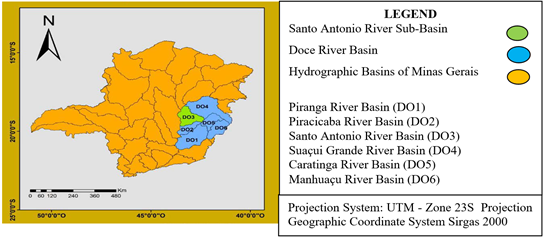
The Sapo Mine, located in the Santo Antônio River basin in Minas Gerais, covers an area of 10,774 km², representing 15.12% of the Doce River basin, Figure 1.
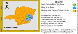
This basin encompasses 29 municipalities and faces significant challenges associated with increased erosion and sedimentation. These problems are exacerbated by the region's geomorphological characteristics and inappropriate land use.
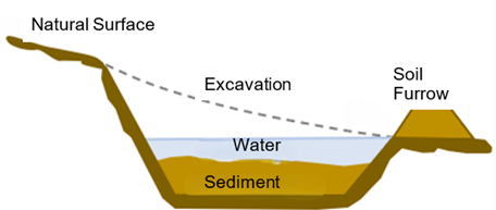
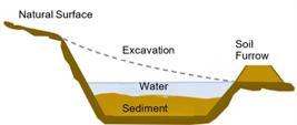
SUMPs (also called sedimentation ponds), Figure 2, are structures used by the mining industry to aid environmental control by promoting sediment retention and, consequently, improving important water quality parameters before discharge or reuse. SUMPs are temporary structures designed to store water and sediment. They are essential for water management in mines, especially in areas where water can accumulate due to rainfall.
Several studies on SUMPs have revealed that their configuration and size, inflow rate, and particle settling velocity are important factors in determining the sediment removal efficiency of reservoirs (Wilson et al., 2009; Pathapati and Sansalone, 2009; Howard et al., 2012; Kaushal et al., 2012; McIntire et al., 2012).
The relationships between removal efficiency and system parameters have been identified using a comprehensive approach in previous studies, but there is still a lack of quantified information and in-depth analyses of the hydraulic characteristics of the reservoir flow field, which are crucial for optimization and new designs (Naghettini and Pinto, 2007).
Several reservoir structures have been evaluated to improve sediment management from intense flow in rainy weather (Pitt and Field, 2004; Andoh et al., 2007; Brar et al., 2016). Several reservoirs can be considered useful for the containment of natural solids (Lau et al., 2001; Walch et al., 2009; Alam et al., 2018; Basham et al., 2019).
This study analyzed rainfall data obtained by the PSS-01 Rain Gauge installed at the Sapo Mine, with records dating back to 2018. According to Back and Cadorin (2020), characterizing the variability of intense rainfall over its duration is essential for estimating runoff. In this perspective, the intensity-duration-frequency (IDF) relationship of rainfall or curves is used to obtain reliable design flow values, which are generated from rainfall monitoring commonly performed using rain gauges (Silva Júnior et al., 2020; Morbidelli et al., 2021). The statistical method of "Quantiles" was used to classify rainfall intensity. These quantiles divide a set of rainfall data into percentage intervals, allowing the classification of rainfall into categories, with mean and standard deviation, as it does not depend on the assumption of a normal distribution of the data (Morbidelli et al., 2020; Hosking and Wallis, 1997). The quantiles were defined based on previous studies, using historical rainfall data recorded at the ANA rain gauge station (PLU 1943002) in Conceição do Mato Dentro, covering the period from 1941 to 2018. ArcGIS software was used to create thematic maps, which enabled the integration and analysis of spatial data. The orthophotos were obtained from drone flights, ensuring high precision and resolution in the images. Microsoft Excel was used to create the graphs.
3. RESULTS AND DISCUSSION
The construction of Table 1 enabled the necessary analyses for projecting future scenarios regarding regional precipitation and its direct relationship with erosion processes in the study area. The statistical method adopted was based on 5 annual accumulation intervals, divided into: very dry (precipitation accumulation below 15% of the expected value), dry (precipitation accumulation between 15% and 35% of the expected value), normal (precipitation accumulation between 35% and 65% of the expected value), rainy (precipitation accumulation between 65% and 85% of the expected value.) and very rainy (precipitation accumulation above 85% of the expected value).
Maximum precipitation intensity was efficiently adjusted using a probabilistic model. Based on the Gumbel distribution model, the precipitation intensity-duration-frequency model had its parameters adjusted to estimate precipitation intensity for different durations and return periods (Santos et al., 2020; Shabankareh and Abedini, 2023). The maximum 30-minute precipitation intensity for a two-year return period demonstrated a significant erosion-causing capacity, based on the maximum erosivity energy. Erodibility risk was classified as moderate for Ferralsols (known for their reddish or brownish color, typical of humid tropical regions, with high concentrations of minerals such as kaolinite and iron oxides) and Leptosols (shallow, poorly developed soils, often found in areas with rugged terrain), and low for Arenosols (soils with a high proportion of sand and a low amount of clay, making them light and well-drained, but with lower water and nutrient retention) (Cassol et al., 2018).
Values of maximum annual precipitation intensity (mm/h), lasting from 5 minutes to 90 days, for return periods of 2, 5, 10, 25, 50, 100, 200, 500, 1000, 5000 and 10000 years.
In mining, calculating the sedimentation rate is crucial for understanding the input and volume of sediment deposited in containment structures and dikes, and is essential for planning cleanup efforts for these structures, whether temporary or permanent (Depiné et al., 2011; Farias, 2008; Alves, 2021; Ganora et al., 2023; Gnecco et al., 2023; Wadhwa et al., 2023).
For the year under review, 2024, the sedimentation rate was calculated by measuring the contribution basin and the volume of sediment input to a containment structure located in the mining area, with a capacity of 7,000 m3, during the first three months of the year-the rainy season, when sediment deposition significantly increases, enabling a more representative analysis.
Calculation Summary:
Pit Area: 21 hectares
Sediment Removal: 8,000 m3
Rate = 380 m3/ha
Annual Rate = (380 x 2) = ~800 m3/ha
Considering that siltation occurs over three months, half of the rainy season, the calculated rate was higher than the 600 m3/ha recommended by Pinheiro (2011).
According to Pinheiro (2011), in areas occupied by mining activities in the United States, the EPA (Environmental Protection Agency) presented specific sediment contribution values ranging from 300 m3/ha.year to 600 m3/ha.year.
Hydraulic structures are components designed to store water and sediment, in addition to directing surface drainage to SUMPs. This system includes pumps and discharge piping to safe areas, as previously recommended to prevent erosion. During the rainy season, sediment accumulation can compromise the containment capacity of structures. For SUMPs that were implemented with adequate area, cleaning is scheduled to occur after the rainy season, in April 2025. For structures with smaller footprints than necessary, intermediate cleaning was performed to ensure their operation.
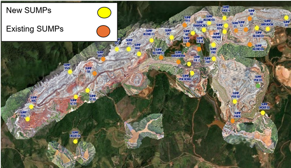
The 2024 Rainfall Plan included the sizing of drainage structures to manage surface water and ensure the continuity of mining activities during the rainy season. This approach aims to reduce the amount of sediment reaching the dikes, which act as the final barriers, helping to reduce turbidity before effluent is released into the drains surrounding the mine. For the Sapo Mine, 14 existing structures were planned to be cleaned and 26 new structures were built to contain stormwater and sediment (Figure 3).
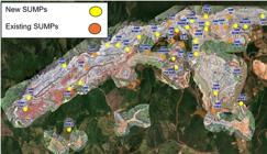
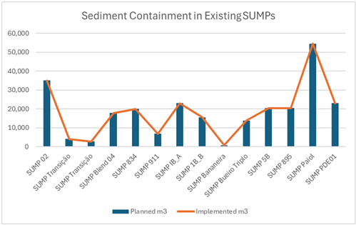
The existing SUMPs are the structures that remained in the same area in 2023, without interaction with the 2024 Mining Plan. During this period, dredging and adjustment of the surrounding drainage systems were carried out to ensure the structures' operability. The cleaning of the 14 SUMPs was carried out in accordance with the structure's design, ensuring adherence to the drainage system (Table 2 and Figure 4).
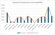
After analyzing the 2024 Mining Plan and preparing hydrological and hydraulic studies, 26 new SUMPs were designed and distributed based on technical criteria throughout the mine, as shown in Table 3 and Figure 5. The objective was to direct the majority of the surface water and sediment volume to the new structures.
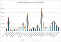
Construction was scheduled to take place between April and October; however, the schedule was delayed until November, during the rainy season. Throughout the project, topographic surveys and new volume measurements were conducted to verify the alignment between the planned and actual works.
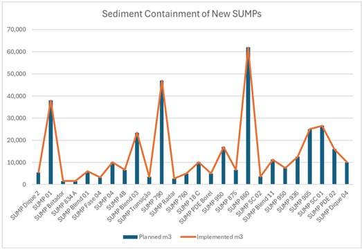
The topographic survey conducted on the planned structures of the 2024 Rainfall Plan revealed that the volume retained in the SUMPs was 679,797 m³, a value slightly below the initial forecast of 683,020 m³. This difference of approximately 1% is considered minor and does not have a significant impact on the overall project outcome.
To ensure the proper execution of the 2024 Rainfall Plan, constant monitoring was implemented, with weekly field inspections, along with topographic surveys that recorded excavation progress. Reports and alignment meetings were conducted with the multidisciplinary team of geotechnics, planning, topography, and mine services.
The efficiency and effectiveness of the structures was verified for both the existing SUMPs and the new SUMPs. The objective of this verification was to identify potential flaws in the execution process. In the case of existing SUMPs, dredging of the structures was carried out, with the removal of sediments accumulated during the year 2023, an activity distinct from the execution of a new SUMP, where the excavation is carried out in in situ material.
3.1. New Areas Susceptible to Sediment Input
New active mining areas generate a significant volume of sediment, which is transported primarily during the rainy season. In these regions, SUMPs are sized based on a modeled sedimentation rate of 800 m³/ha, resulting in robust structures with larger volumes to avoid intermediate cleaning. This occurs because, during the rainy season, sediments become saturated, forming a sludge that makes it difficult to desilt the structures.
During the study, it was observed that certain conditions can impact the adopted sedimentation rate. During continuous rainy events, sediments settle, and the input follows the modeled rate. However, during rainy periods followed by two days of drought, when new precipitation occurs, the sediment input is higher than expected, repeating itself in rainy and dry cycles. This phenomenon results in premature silting in some SUMPs. The removed material undergoes geological evaluation, with drilling to verify the feasibility of reusing the sediments. Depending on its composition, the sediment can be used as access lining or, if appropriate, returned to the production process. The discarded material is sent to the Waste Rock Pile (PDE).
The reuse of materials from dredging demonstrates a commitment to sustainability, and discarded materials are sent to the PDE and disposed of within the technical standards recommended for waste piles.
Functional aspects observed in SUMPs:
1. Water Control - preventing excessive water accumulation in mining areas, which can cause safety and operational performance problems.
2. Sediment particle size separation - allowing solid particles to settle, facilitating the removal of clean water for effluent management.
3. Environmental Protection - reducing environmental impact by ensuring that sediments are retained in the structure, contributing to improving the quality of water discharged into drainage systems.
4. Water Reuse - existing water is used to supply the trucks that spray the mine, contributing to the mine's environmental sustainability.
4. CONCLUSIONS
The structural and hydraulic characteristics, performance, and efficiency of the SUMPs installed at Minas do Sapo, in Conceição do Mato Dentro, Minas Gerais, owned by Anglo American, are presented. They contain sediment during the Annual Rainy Season. The following conclusions can be drawn:
1. The model's adopted procedure, which incorporates methodologies such as lengthening the water flow path, attenuating flow velocity, and facilitating particle adhesion, produces a substantial increase in the particle removal efficiency of the SUMPs. The efficiency improvement observed with the improved model is approximately 15 to 25%.
2. Executing the works during the dry season, with the entire fleet of vehicles and personnel dedicated to constant monitoring, was essential to ensuring the expected performance of the structures without impacting the mine's production and maintenance activities.
3. Continuous monitoring of the 40 SUMPs, along with analysis of the dike water, allowed for obtaining information and verifying the effectiveness of the adopted solutions.
4. The results prove that the sediment containment plan was effective, contributing to the reduction of turbidity in the dikes and residual flows within the parameters established by environmental agencies.
5. Thus, the Containment Plan has established itself as an essential strategy for minimizing the impacts of rainfall on production and ensuring operational safety, while also contributing to environmental control in the Santo Antônio River basin.
5. DATA AVAILABILITY STATEMENT
Data availability not informed.
6. ACKNOWLEDGEMENTS
This work was carried out with support from the Coordination for the Improvement of Higher Education Personnel - Brazil (CAPES) - Financing Code 001 and the National Water and Basic Sanitation Agency (ANA) through CAPES/UNESP Agreement No. 951420/2023. I would like to thank the Professional Master's Programme in Water Resources Management and Regulation - ProfÁgua for the technical and scientific support provided to date.
7. REFERENCES
-
ALAM, M. Z.; ANWAR, A. F.; HEITZ, A.; SARKER, D. C. Improving stormwater quality at source using catch basin inserts. Journal of Environmental Management, n. 228, p. 393-404, 2018. https://10.1016/j.jenvman.2018.08.070
» https://10.1016/j.jenvman.2018.08.070 - ALVES, M. M. Efeitos do dimensionamento de micro reservatórios com tempo de retorno proporcional ao tamanho do lote: uma abordagem progressiva para drenagem pluvial. 2021. Trabalho de Conclusão de Curso (Engenharia Hídrica) - Universidade Federal do Rio Grande do Sul, Porto Alegre, 2021.
- ANDOH, R. Y. G.; ALKHADDAR, R. M.; FARAM, M. G.; CARROLL, P. Pollutants washout - the missing dimension in urban stormwater treatment. In: SOUTH PACIFIC STORMWATER CONFERENCE, 5., 16-18 May 2007, Auckland, New Zealand. Proceedings[...] IPENZ Foundation, 2007.
- ARONSON, G.; WATSON, D.; PISANO, W. Evaluation of Catchbasin Performance for Urban Stormwater Pollution Control. EPA-600/2-83-043. Cincinnati, OH: USEPA, 1983. 78p.
-
BACK, A. J.; CADORIN, S. B. Chuvas Máximas Diárias e Equações de Intensidade-Duração-Frequência para o estado do Amapá, Brasil. Revista brasileira de climatologia, v. 26, 2020. https://doi.org/10.5380/abclima.v26i0.69844
» https://doi.org/10.5380/abclima.v26i0.69844 -
BASHAM, D. L.; ZECH, W. C.; DONALD, W. N.; PEREZ, M. A. Design and construction of full-scale testing apparatus for evaluating performance of catch basin inserts. Journal Sustainable Water Built, v. 5, n. 1, 2019. https://10.1061/JSWBAY.0000868
» https://10.1061/JSWBAY.0000868 - BRAR, P.; DRAKE, J.; BRAUN, S. Catch basin shield: improving sediment retention of conventional catch basins. In: INTERNATIONAL CONFERENCE ON PLANNING AND TECHNOLOGIES FOR SUSTAINABLE MANAGEMENT OF WATER IN THE CITY, 9., 2016, Graie, Lyon. Proceedings[...] IWA, 2016.
-
CASSOL, E. A.; SILVA, T. S.; ELTZ, F. L. F.; LEVIEN, R. Soil Erodibility under Natural Rainfall Conditions as the K Factor of the Universal Soil Loss Equation and Application of the Nomograph for a Subtropical Ultisol. Revista Brasileira de Ciência do Solo, v. 42, 2018. https://doi.org/10.1590/18069657rbcs20170262
» https://doi.org/10.1590/18069657rbcs20170262 - CETESB. Drenagem urbana: manual de projeto. São Paulo, 1979. 466p.
-
DEPINÉ, H.; PINHEIRO, A.; KAUFMANN, V.; SILVA, M. R. Transporte de Sedimentos em Suspensão em Áreas Agrícolas em Diferentes Escalas Espaciais. Revista Brasileira de Recursos Hídricos, v. 16, n. 1, p. 97-104, 2011. https://10.21168/rbrh.v16n1.p97-104
» https://10.21168/rbrh.v16n1.p97-104 - FARIAS, T. R. L. Produção de sedimentos em bacias hidrográficas sob diferentes contextos geoambientais: medidas e modelagem. 2008. Dissertação (Engenharia Civil) - Universidade Federal do Ceará, Fortaleza, 2008.
-
GANORA, D.; EVANGELISTA, G.; CORDERO, S.; CLAPS, P. Design flood hydrographs: a regional analysis based on flood reduction functions. Hydrological Sciences Journal, v. 68, n. 2, p. 325-340, 2023. https://doi.org/10.1080/02626667.2022.2153051
» https://doi.org/10.1080/02626667.2022.2153051 -
GAUR, A.; SCHARDONG, A.; SIMONOVIC, S. P. Gridded Extreme Precipitation IntensityDuration-Frequency Estimates for the Canadian Landmass. Journal of Hydrologic Engineering, v. 25, n. 6, 2020. https://doi.org/10.1061/(ASCE)HE.1943-5584.0001924
» https://doi.org/10.1061/(ASCE)HE.1943-5584.0001924 -
GNECCO, I.; PALLA, A.; LA BARBERA, P.; ROTH, G.; GIANNONI, F. Defining intensity duration-frequency curves at short durations: a methodological framework. Hydrological Sciences Journal, v. 68, n. 11, p. 1499-1512, 2023. https://doi.org/10.1080/02626667.2023.2224002
» https://doi.org/10.1080/02626667.2023.2224002 - GUO, Q. Stormwater Manufactured Treatment Devices: Certification Guidelines. American Society of Civil Engineers, Reston, 2017.
- HOSKING, J. R. M.; WALLIS, J. R. Regional Frequency Analysis - An Approach Based on L-Moments. Cambridge: Cambridge University Press, 1997. 224p.
-
HOWARD, A. K.; MOHSENI, O.; GULLIVER, J. S.; STEFAN, H. G. Hydraulic analysis of suspended sediment removal from storm water in a standard sump. Journal of Hydraulic Engineering, v. 138, n. 6, p. 491-502, 2012. https://10.1061/(ASCE)HY.1943-7900.0000544
» https://10.1061/(ASCE)HY.1943-7900.0000544 - HVITVED-JACOBSEN, T.; VOLLERTSEN, J.; NIELSEN, A. H. Urban and Highway Stormwater Pollution: Concepts and Engineering. Boca Raton: CRC Press, 2010.
-
KAUSHAL, D. R.; THINGLAS, T.; TOMITA, Y.; KUCHII, S.; TSUKAMOTO, H. Experimental investigation on optimization of invert trap configuration for sewer solid management. Powder Technology, v. 215, p. 1-14, 2012. https://doi.org/10.1016/j.powtec.2011.08.029
» https://doi.org/10.1016/j.powtec.2011.08.029 - KATHURIA, D. Vir; NAWROCKI, M. A.; BECKER, B. C. Effectiveness of surface mine sedimentation ponds. Cincinnati: USEPA, 1976.
- LAGER, J. A.; SMITH, W. G.; LYNARD, W. G.; FINN, R. M.; FINNEMORE, E. J. Urban Stormwater Management and Technology: Update and Users’ Guide. EPA-600/8-77-014. Cincinnati: USEPA, 1977.
-
LAU, S. L.; KHAN, E.; STENSTROM, M. K. Catch basin inserts to reduce pollution from stormwater. Water Science Technology Journal, v. 44, n. 7, 23-34, 2001. https://10.2166/wst.2001.0381
» https://10.2166/wst.2001.0381 - MCINTIRE, K. D.; HOWARD, A.; MOHSENI, O.; GULLIVER, J. S. Assessment and Recommendations for Operation of Standard Sumps as Best Management Practices for Stormwater Treatment. Vol. 2, (No. MN/RC 2012-13). Minneapolis: St. Anthony Falls Laboratory, University of Minnesota, 2012.
-
MORBIDELLI, R.; GARCÍA-MARÍN, A. P.; MAMUN, A. A.; ATIQUR, R. M.; AYUSOMUÑOZ, J. L.; TAOUTI, M. B. et al The history of rainfall data time-resolution in a wide variety of geographical areas. Journal of Hydrology, v. 590, n. 125258, 2020. https://doi.org/10.1016/j.jhydrol.2020.125258
» https://doi.org/10.1016/j.jhydrol.2020.125258 -
MORBIDELLI, R.; SALTALIPPI, C.; DARI, J.; FLAMMINI, A. A review on rainfall data resolution and its role in the hydrological practice. Water, v. 13, n. 1012, 2021. https://doi.org/10.3390/w13081012
» https://doi.org/10.3390/w13081012 - NAGHETTINI, M.; PINTO, E. J. D. A. Hidrologia estatística. Belo Horizonte: CPRM, 2007.
-
ONEDA, T. M. S.; BARROS, V. G. On stormwater management master plans: comparing developed and developing cities. Hydrological Sciences Journal, v. 66, n. 1, p. 1-11, 2021. https://doi.org/10.1080/02626667.2020.1853131
» https://doi.org/10.1080/02626667.2020.1853131 -
PATHAPATI, S. S.; SANSALONE, J. J. CFD modeling of a storm-water hydrodynamic separator. Journal of Environmental Management, v. 135, n. 4, 191-202, 2009. https://10.1061/(ASCE)0733-9372(2009)135:4(191)
» https://10.1061/(ASCE)0733-9372(2009)135:4(191) - PINHEIRO, M. C. Diretrizes para elaboração de estudos hidrológicos e dimensionamentos hidráulicos em obras de mineração. Revista Brasileira de Recursos Hídricos, v. 1, 2011.
- PITT, R.; FIELD, R. Catchbasins and inserts for the control of gross solids and conventional stormwater pollutants. In: AMERICAN SOCIETY OF CIVIL ENGINEERS WORLD WATER AND ENVIRONMENTAL RESOURCES CONGRESS, June 27-July 1, 2004, Salt Lake City, UT. Proceedings[...] Boca Raton: CRC Press, 2004. p. 1-10.
-
SANTOS, M. A. C. M.; VELLAME, L. M.; ARAUJO, J. C.; SILVA, A. J. P. Hydrological characterization of rainfall and its potential erosivity in the middle course of Salitre river basin in the Brazilian semi-arid. Revista brasileira de climatologia, v. 27, n. 16, p. 326348, 2020. https://doi.org/10.5380/abclima.v27i0.72823
» https://doi.org/10.5380/abclima.v27i0.72823 -
SHABANKAREH, R. N. T.; ABEDINI, M. J. Implementation of a probability matching method in developing intensity-duration-frequency relationships for sub-daily durations using IMERG satellite-based data. Hydrological Sciences Journal, v. 68, n. 12, 2023. https://doi.org/10.1080/02626667.2023.2229817
» https://doi.org/10.1080/02626667.2023.2229817 - SILVA JÚNIOR, J. A.; RAMOS, F. S. F.; OLIVEIRA, D. F.; LEÃO, E. A. L.; CHAVES, M. B. Curvas intensidade-duração-frequência para chuva de projeto no sertão alagoano. In: SIMPÓSIO DE RECURSOS HÍDRICOS NO NORDESTE, 15., 2020, Online. Trabalhos[...] ABRHidro, 2020.
- WALCH, M.; COLE, R.; POLASKO, W.; WALTERS, D.; FROST, W.; DINICOLA, P.; GNEO, R. Evaluation of the Performance of Four Catch Basin Inserts in Delaware Urban Applications. Dover: Delaware Department of Transportation, 2009.
-
WADHWA, A.; BUDAMALA, V.; KUMMAMURU, P. K.; KASIVISWANATHAN, K. S.; SRIMURUGANANDAM, B. Low-impact development (LID) control feasibility in a small-scale urban catchment for altered climate change scenarios. Hydrological Sciences Journal, v. 68, n. 13, 2023. https://doi.org/10.1080/02626667.2023.2239797
» https://doi.org/10.1080/02626667.2023.2239797 -
WILSON, M. A.; MOHSENI, O. M.; GULLIVER, J.; HOZALSKI, R. M.; STEFAN, H. G. Assessment of hydrodynamic separators for storm-water treatment. Journal of Hydraulic Engineering, v.135, n. 5, 383-392, 2009. https://10.1061/(ASCE)HY.1943-7900.0000023
» https://10.1061/(ASCE)HY.1943-7900.0000023 -
YANG, Y.; HUANG, B.; ZHU, D. Z. Experimental study of sediment washout from stormwater sumps. Water Science Technology Journal, v. 86, n. 9, p. 2454-2464, 2022. https://10.2166/wst.2022.329
» https://10.2166/wst.2022.329 -
ZAPICO, I. et al Evaluation of sedimentation pond performance for a cleaner water production from an open pit mine at the edge of the Alto Tajo Natural Park. Journal of Cleaner Production, v. 280, p. 124408, 2021. https://doi.org/10.1016/j.jclepro.2020.124408
» https://doi.org/10.1016/j.jclepro.2020.124408
Edited by
-
Editor-in-Chief:
Nelson Wellausen Dias https://orcid.org/0000-0002-9507-9211