
 Machine Learning based literature review of Land Administration Domain Model (LADM): a structural topic modelling approach
Abstract:
The Land Administration Domain Model (LADM) standardizes land management by integrating legal, spatial, and administrative information. This study examines LADM-related research using Structural Topic Modelling (STM) on 199 publications (2008-2024). Seven dominant topics emerged: land administration systems, property valuation, 3D cadastral modelling, LADM extensions, building and spatial rights, cadastral systems, and land object modelling. Key findings highlight sustained interest in spatial modelling, legal frameworks, and cadastral data integration, alongside emerging trends such as country-specific LADM profiles (e.g., China, Kenya, Malaysia) and technological advancements like BIM and marine georegulation models. Challenges persist in data complexity, semantic interoperability, and 4D cadastres. The study recommends expanding semantic models, fostering interdisciplinary collaboration, and developing tailored national profiles to enhance LADM’s applicability and promote sustainable land management practices globally.
Keywords:
Land Administration Domain Model; Structural Topic Modelling; Machine Learning; Spatial Data Infrastructure; Sustainability; Land use
1. Introduction
The LADM is a foundational standard in modern land administration, recognised internationally as ISO 19152:2012. Its primary purpose is to streamline and standardise the management of land-related information in diverse jurisdictions. By providing a conceptual data model, LADM bridges legal, spatial, and administrative dimensions, fostering efficient land management and sustainable development (Van Oosterom and Lemmen 2015b, van Oosterom and Lemmen 2015a). One of the standout features of LADM is its standardisation. As one of the first ISO spatial domain standards, it offers a global vocabulary that harmonises terminology and practices in land administration (Kalogianni et al. 2017, Mehmood et al. 2022). Flexibility is another key strength, as the model can be tailored to specific national contexts and supports both 2D and 3D representations of land parcels and associated legal spaces (Lemmen et al. 2015). This adaptability has made LADM a vital tool to address the complexities of land tenure systems and cadastral records. Furthermore, its integration of legal and spatial information enables the effective management of rights, restrictions, and responsibilities (RRRs), which are a central point to efficient land governance (Xu et al. 2022). The focus on interoperability ensures seamless interaction with other land administration systems and standards (Aydinoglu and Bovkir 2017) as it is composed of three primary packages: the Party Package, which involves individuals and organisations; the Administrative Package, which covers land-related rights and responsibilities; and the Spatial Unit Package, which includes parcels, buildings, and utility networks (Lemmen et al. 2011).
The real-world applications of LADM underline its versatility. For example, China has utilised LADM to reform its rural homestead tenure system, while Kenya has implemented the model to modernise its land administration processes (Okembo et al. 2024a). Technological advancements further enhance its relevance, with integrations such as BIM and Industry Foundation Classes (IFC) supporting the management of complex 3D cadastres (Liu et al. 2024, Gkeli and Potsiou 2023, Mehmood et al. 2024a). LADM also aligns with the Sustainable Development Goals (SDGs), aiding countries in achieving efficient land use and equitable management practices (Ahsan et al. 2024). Current developments, including Edition II, aim to expand its scope with formal semantics and explicit constraints (Polat et al. 2022). However, challenges persist, such as balancing comprehensive functionality with simplicity to avoid overcomplexity (Kaufmann 2013). A holistic approach that integrates institutional, procedural, and human resource considerations is essential for its successful adoption (Kalantari et al. 2015). In this study, we explore research trends related to LADM using Structure Topic Modelling (STM), as it provides a robust framework for identifying hidden thematic structures within large text corpora, enabling a deeper understanding of evolving research patterns. The primary objectives of this paper are threefold: to analyse research trends in LADM studies, to identify thematic structures and latent topics, and to suggest future research directions. By applying STM to a comprehensive data set of LADM-related publications, our aim is to uncover key research areas, emerging themes, and interdisciplinary links. This analysis not only highlights the progress made in LADM research but also identifies knowledge gaps and potential areas for future exploration, contributing to the continued development and refinement of LADM within the global landscape of land administration.
2. Review of Data Source and Overview
To achieve the aim of this article, a comprehensive and systematic search was carried out in two renowned academic databases: Scopus (Baas et al. 2020) and Web of Science (WoS) (Birkle et al. 2020). These databases, well established for their expansive coverage of peer-reviewed literature across disciplines, were selected to ensure a robust and comprehensive dataset. The selection of Scopus and WoS as primary data sources proved advantageous, leveraging their complementary strengths to capture a diverse, yet high-quality dataset. Scopus provided broad multidisciplinary coverage (Boyle and Sherman 2005, Ballew 2009), while WoS offered enhanced citation analytics (Haustein and Larivière 2015), ensuring that no significant contributions were overlooked. Using a targeted search strategy, the keyword “Land Administration Domain Model” was exclusively used. This precise approach ensured that the documents retrieved were highly specific to the topic under investigation, eliminating ambiguity in relevance. The search was further refined by restricting results to publications written in English, a decision made to standardise the language for analysis and interpretation.
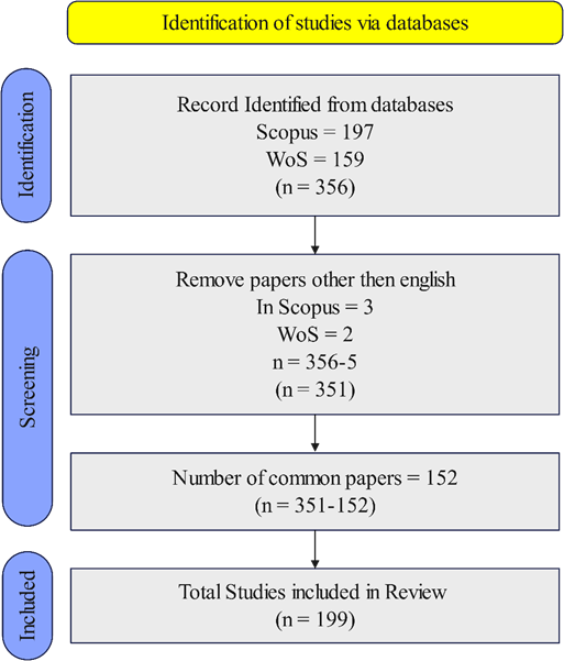
The search yielded a total of 356 records, comprising 197 from Scopus and 159 from WoS. A rigorous selection process was employed to ensure the quality and relevance of the selected literature. Non-English publications, though minimal, were excluded, reducing the data set by five entries. Subsequently, duplicates were identified in both datasets and removed, resulting in a final dataset of 199 unique documents. This rigorous approach ensured the relevance and alignment with the study’s focus, creating a strong foundation for future analysis. The temporal span of the dataset, from 2008 to 2025, highlights the sustained academic interest in LADM over the years, with an annual growth rate of 4.16%, signalling a steady expansion in scholarly contributions to this domain. The screening process, as summarised in Figure 1, demonstrates the transparency and systematic methodology applied in the collection and refinement.

The dataset’s composition reflects a diverse range of academic contributions, including 141 journal articles, 25 conference articles, and 6 book chapters, among others. The corpus also reveals notable trends in authorship and collaboration, with a total of 352 authors contributing to the collected works and an average of 3.7 co-authors per document. International co-authorships accounted for 30.15% of the total, underscoring the global collaborative nature of LADM-related research. These statistics, along with other metrics such as the number of keywords and document types, are detailed in Table 1, which offers a comprehensive overview of the structure of the data set. The inclusion of 292 Keywords Plus and 519 authors-provided keywords further enriched the dataset, providing a detailed foundation for thematic analysis. These metrics, combined with an average document age of 4.91 years and an average citation count of 10.74 per document, underline the relevance and scholarly impact of the literature under review. This data set, which reflects both the breadth and depth of LADM scholarship, serves as an optimal foundation for conducting STM analysis and advancing understanding in this critical field of land administration research.
3. Structural Topic Modelling
Topic modelling is a statistical method designed to uncover the latent semantic structure in large text collections. Widely used in fields such as text mining, information retrieval, and natural language processing, it provides a framework for analysing thematic patterns within textual data (Kherwa and Bansal 2020, Lakshmi Prasanna and Rajeswara Rao 2019). In this research, the STM is utilised due to its ability to address the limitations of other methods like Latent Dirichlet Allocation (LDA) and the Correlated Topic Model (CTM). LDA assumes topics are independent, which can be unrealistic in real-world data where topics are often correlated (Blei and Lafferty 2005, Prayote and Songklang 2018). It also struggles with short texts, limiting its application in datasets where word relationships are essential (Tajbakhsh and Bagherzadeh 2019). Although CTM improves on LDA by modeling topic correlations, it is computationally intensive and less scalable for large datasets (Caballero et al. 2012, Luo et al. 2024). STM, on the other hand, incorporates document-level metadata as covariates, enabling a deeper understanding of how topics vary with contextual variables, such as time or author characteristics. This makes STM more interpretable and relevant for analysing topic evolution and external associations, offering a significant advantage for research where metadata plays a key role (Hong et al. 2022). Consequently, STM provides a robust and flexible approach to uncovering and explaining thematic structures.
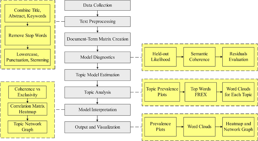
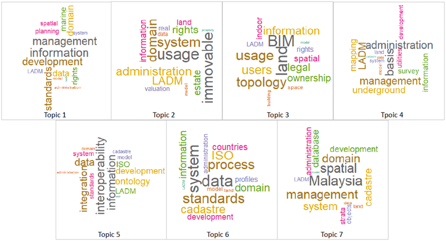
Figure 2 illustrates the methodological workflow followed in this research to conduct STM. The process is systematically divided into multiple stages to ensure rigorous and reproducible analysis of textual data. The workflow begins with data collection, where relevant data sources were used as described in previous sections and then document titles, abstracts, and keywords, are gathered to form the research corpus. This stage ensures that the input data comprehensively represents the study domain. Next, in the text preprocessing stage, key text-cleaning operations such as stop word removal, lowercasing, removal of punctuation and numbers, and stemming are performed. These operations standardise and reduce the textual data to its meaningful components, preparing it for subsequent analysis. A document-term matrix is then created, transforming the corpus into a structured numerical representation suitable for topic modeling. The model diagnostics stage plays a crucial role in selecting an optimal model. Three key diagnostic metrics Held-out Likelihood, Semantic Coherence, and Residuals Evaluation are evaluated. These metrics assess model performance to determine the most appropriate number of topics, ensuring the topics identified are both distinct and meaningful. The topic model estimation phase involves applying the STM algorithm to estimate topic distributions across the documents. Following this, the topic analysis stage focuses on generating outputs such as topic prevalence plots (to assess topic trends over time), top words (FREX), and word clouds for each topic, which visually represent the most significant words for each topic.

In the Model Interpretation stage, additional analytical tools, such as coherence vs exclusivity plots, correlation matrix heatmaps, and topic network graphs, are employed to examine the relationships and distinctiveness of the topics. Finally, the results are synthesised in the output and visualisation stage, providing a clear and comprehensive understanding of the identified topics. This methodological workflow ensures a structured approach to STM, facilitating in-depth analysis and visualization of the thematic structures within the data.
3.1 Optimal Number of Topics
The selection of an optimal number of topics is fundamental to the reliability and interpretability of topic-modelling results. For this study, a systematic evaluation of multiple diagnostic metrics was performed to identify the most appropriate number of topics. The analysis covered topic models ranging from 2 to 30 topics, with diagnostic results summarised in Table 2 and visualised in Figure 3. Based on the findings, a seven-topic model was selected, striking an ideal balance between coherence, granularity, and overall model fit.
The diagnostic process relied on four key metrics: held-out likelihood, residuals, semantic coherence, and lower bound. The held-out likelihood (Figure 3, top left) evaluates the model’s predictive performance of the model on unseen data, with higher values indicating better generalisability (Fu et al. 2021, Fu et al. 2019). The likelihood metric exhibited a decline as the number of topics increased, especially after 10 topics, suggesting diminishing predictive returns for more complex models. The seven-topic model retained a relatively high held-out likelihood, ensuring robust generalisability without unnecessary complexity. Similarly, residuals (Figure 3, top-right), which measure unexplained variance in the data set (Weston et al. 2023), provided additional support for the seven-topic model. Residual values remained low and stable for models with fewer topics, but a sharp increase was observed beyond 25 topics, signalling overfitting. The residual behaviour of the seven-topic model fell within the stable range, indicating that it achieved a suitable balance between data fit and generalisation capacity.
The interpretability of the model was assessed using semantic coherence (Figure 3 bottom left). Coherence scores, which reflect the semantic consistency of words within topics (Goyal and Kashyap 2024), declined sharply after five topics, with further reductions as the number increased. The seven-topic model retained a sufficient level of coherence, capturing meaningful and interpretable themes without excessive fragmentation. The trade-off between coherence and granularity was particularly evident in the coherence curve, as fewer topics aggregated distinct themes, whereas more topics fragmented coherent ones. Thus, seven topics effectively captured thematic structure while preserving clarity. The lower bound metric (Figure 3, bottom-right), which measures the overall fit of the model (Weston et al. 2023), consistently increased as the number of topics grew. However, the rate of improvement decreased significantly after seven topics, indicating a decrease in model complexity. The seven-topic model represents an inflection point where the balance between complexity and fit is optimised, justifying its selection as the most parsimonious choice.
From a domain-specific perspective, the LADM requires a nuanced yet interpretable representation of key themes, such as spatial modelling, land rights, and legal frameworks. A five-topic model would risk oversimplifying these themes by aggregating multiple distinct concepts, whereas models with more than seven topics could unnecessarily fragment these coherent themes into overly specific and redundant categories. The seven-topic model aligns well with the theoretical complexity of LADM, providing sufficient granularity while maintaining thematic integrity. Finally, the decision to select seven topics was based on a rigorous diagnostic process, balancing multiple metrics to achieve interpretability, granularity, and fit. This approach ensures both methodological rigour and practical relevance, making the findings valuable for both theoretical advancements and real-world applications.

3.2 Characteristics of the Latent Topics
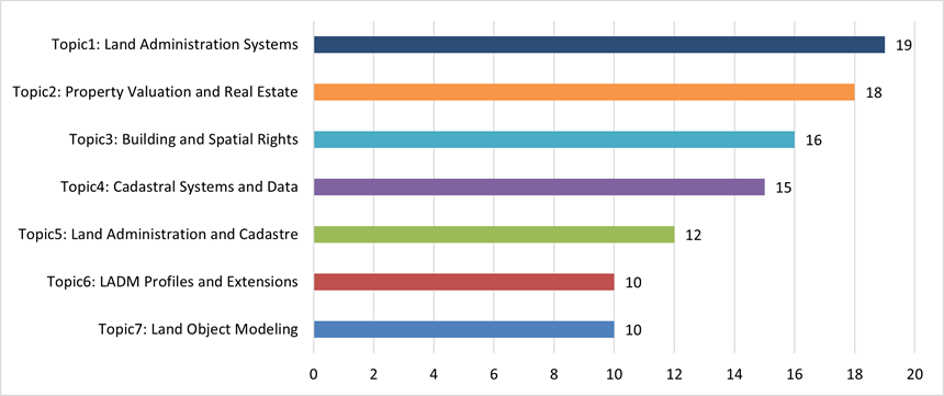
Based on the diagnostics performed to determine the optimal number of topics, the STM analysis was performed with seven topics, each representing key areas of focus in LADM-related research. Figure 4 represents the prevalence of these topics, highlighting the varying levels of academic attention dedicated to distinct themes within the field. The results show that Land Administration Systems emerge as the most prominent area, reflecting its foundational role in integrating legal, spatial, and administrative frameworks critical for efficient land governance. Property Valuation and Real Estate follows closely, emphasising the importance of standardised valuation systems and equitable property taxation in modern land administration.
Building and Spatial Rights also feature prominently, indicating a strong focus on urban property management and the integration of 3D cadastres through technologies like BIM. Cadastral Systems and Data highlight the emphasis on data interoperability and the efficient management of cadastral information, while Land Administration and Cadastre reflect the adoption of modular and flexible approaches to address diverse institutional needs. Additionally, LADM Profiles and Extensions demonstrate the adaptability of LADM to specific country contexts, while Land Object Modelling showcases its critical role in managing 3D strata and complex land representations. Together, the figure illustrates the diverse yet interconnected nature of LADM research, paving the way for its future development.

Figure 5 illustrates the correlation heatmap of the identified topics, providing insight into the relationships among the seven latent themes extracted through STM. The diagonal values represent self-correlation, confirming the exclusivity of each topic, while the off-diagonal values indicate pairwise correlations. Most correlations are weak or slightly negative, suggesting minimal overlap between topics, highlighting the distinctiveness of thematic areas. For instance, the low correlation values between topics, such as cadastral systems and land object modelling, emphasise their independence within the LADM framework. This distinctiveness underscores the successful separation of thematic domains and reflects the robustness of the topic modelling process in capturing diverse but nonredundant research foci. This separation is critical for understanding the multifaceted aspects of LADM-related research, ensuring that the extracted topics provide unique and comprehensive insights into the field.

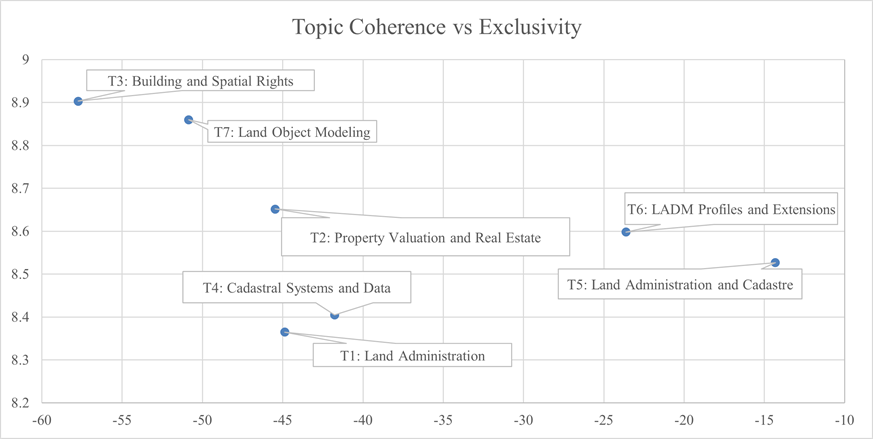
Figure 6 illustrates the relationship between semantic coherence and exclusivity for the seven topics identified in the STM analysis. Semantic coherence, represented on the horizontal axis, measures interpretability, with higher values indicating stronger semantic consistency. Exclusivity, represented on the vertical axis, measures the uniqueness of the terms of a topic compared to others.

4. Review of Latent Topics
This section presents a detailed review of the latent topics identified through the LADM STM analysis as shown in Table 3 and illustrated through word clouds in Figure 7. Each topic captures a distinct dimension of LADM, defined by its most representative terms, reflecting diverse thematic areas such as land administration systems, property valuation, cadastral systems, and 3D spatial modelling. These topics highlight the interdisciplinary nature of LADM research, bridging legal, administrative, and technical aspects. The word clouds provide a visual synthesis of the semantic structure, offering an intuitive overview of each topic’s core focus and relevance within the domain.
4.1 Topic 1: Land Administration Systems
The LADM, established as an international standard (ISO 19152:2012), has become a cornerstone for modern land administration systems. Its primary aim is to provide a conceptual framework that facilitates the establishment and management of efficient and adaptable land administration processes in diverse national contexts. The flexibility enables its application in both 2D and 3D representations of land parcels, making it indispensable for managing RRRs in dynamic legal and spatial environments (Van Oosterom and Lemmen 2015b, van Oosterom and Lemmen 2015a, Kalogianni et al. 2017). A critical feature of LADM is its integration of legal and spatial data, ensuring that land tenure systems are comprehensive and reliable. By linking cadastral, legal and administrative data, LADM supports global initiatives such as the SDGs, particularly in areas such as poverty reduction, sustainable land use, and land tenure reforms (Xu et al. 2022, Lemmen et al. 2015, Ahsan et al. 2024). For example, Ethiopia’s National Rural Land Administration Information System (NRLAIS) uses LADM to secure cadastral records and effectively manage land rights (Getie and Birhanu 2024). Similarly, China’s adoption of LADM has streamlined rural homestead tenure reforms, promoting socioeconomic stability (Xu et al. 2022).
Technological advancements have further enhanced the capabilities of LADM. Its integration with standards such as INTERLIS (it is a standard for the modeling and integration of geodata into contemporary and future geographic information systems) in Switzerland ensures semantic interoperability, while explorations into merging BIM with LADM offer promising solutions for managing complex 3D building rights (Kalogianni et al. 2017, Germann et al. 2017, Zamzuri et al. 2024). Future developments include the second edition of LADM, which will address emerging needs such as marine georegulation, valuation information, and spatial planning (Kara et al. 2024). However, implementing LADM is not without challenges. Maintaining simplicity to prevent complexity-related failures and ensuring data interoperability among institutions remain critical considerations (Kaufmann 2013). For example, the Turkish National GIS project exemplifies efforts to standardise land registry and cadastral data (Aydinoglu and Bovkir 2017). As countries continue to adapt LADM to their specific needs, its potential to modernise global land administration systems and contribute to sustainable development grows exponentially.
4.2 Topic 2: Property Valuation and Real Estate
The integration of property valuation with the LADM has introduced a standardised and efficient framework for managing valuation information and fiscal registries. The proposed Valuation Information Model Package, an extension of LADM, provides a semantic foundation for valuation registries maintained by public authorities. This model facilitates the valuation of mass property by integrating data from various authoritative land and public registries, ensuring accurate and equitable property assessments (Tomić et al. 2021). An innovative addition to this initiative is the LADM Fiscal Extension Module, designed to meet the specific needs of immovable property valuation and taxation. The module improves property identification, facilitates appraisal procedures, and supports tax collection, ensuring consistency in fiscal registries (Çå et al. 2016). Kenyan adaptation of LADM, for example, has integrated legal and customary frameworks to modernise land administration processes, including valuation practices (Okembo et al. 2024a).
The benefits of linking LADM with property valuation models are many. Standardisation in data management supports uniform and accurate property assessments (Çå et al. 2016, Tomić et al. 2021). Additionally, the interoperability facilitated by LADM enables seamless data exchange between cadastre, registries, and valuation systems, which is critical for efficient land administration (Okembo et al. 2024a, Polat and Alkan 2018). This framework not only improves efficiency in data collection and analysis, but also aligns with the SDGs, emphasising effective and sustainable land administration practices (Chen et al. 2024). However, the implementation of property valuation systems presents challenges. The complexity of the model requires simplification to ensure practical application without compromising essential details (Kaufmann 2013). Furthermore, the integration of data from multiple sources demands meticulous planning to maintain accuracy and consistency (Tomić et al. 2021, Polat and Alkan 2018). Despite these challenges, LADM’s flexibility and robust design make it an essential tool to modernise property valuation systems and promote sustainable development globally.
4.3 Topic 3: Building and Spatial Rights
The LADM plays a crucial role in managing building and spatial rights, particularly in urban environments with complex property structures. A key application of LADM is the development of 3D cadastres, which enable the visualisation and management of property rights in high-rise buildings. These cadastres address the challenges of urbanisation by representing legal and physical data in three dimensions, ensuring an accurate depiction of juridical boundaries relative to physical structures (Zamzuri et al. 2024, Kalogianni et al. 2017, Andritsou et al. 2022). LADM also supports spatial planning by integrating spatial plan information and using 3D geoinformation standards such as CityJSON. This facilitates better land use management and enforcement of zoning regulation (Guler 2023, Yilmaz and Alkan 2023). In parallel, structured approaches like classified and clustered data constellation significantly enhance 3D urban data management, improving model efficiency and retrieval (Azri et al. 2016). For example, the Netherlands, Turkey, and Australia have explored integrating BIM with LADM to manage high-rise building information more effectively, thus combining legal and physical perspectives in property administration (Zamzuri et al. 2024).
Despite its advantages, several challenges persist in the use of LADM for building and spatial rights. One limitation is the model’s capacity to represent semantic information, such as functional spaces and building components that are not visible. Integrating BIM into LADM offers a potential solution that allows a more comprehensive representation of building elements (Gkeli and Potsiou 2023, Mehmood et al. 2024c). Another challenge is to ensure semantic interoperability. Efforts to formalise code lists and define explicit constraints can enhance the integration of LADM with other technologies (Kalogianni et al. 2017). Case studies have illustrated the flexibility and applicability. For example, the Cyprus Land Information System has been enhanced with LADM to improve land data management (Elia et al. 2013). These implementations underscore the potential of LADM to modernise land administration practices for building and spatial rights worldwide.
4.4 Topic 4: Cadastral Systems and Data
The LADM has revolutionised the management and organisation of cadastral data by offering a standardised and flexible framework. By supporting the development of cadastral information systems, LADM facilitates efficient and interoperable cadastral systems in diverse jurisdictions. Its ability to accommodate spatial and surveying representations ensures its adaptability to local cadastral practices (Kalantari et al. 2015, Kalogianni et al. 2024, Kaufmann 2013). A notable feature of LADM in cadastral systems is its ability to integrate with other databases, such as those for land cover, valuation, and taxation. This interoperability enhances data sharing between institutions, reducing redundancy, and improving overall data accuracy (Polat et al. 2020). Furthermore, the model’s support for 3D cadastral data management allows it to represent complex property structures, such as high-rise buildings and underground facilities. Efficient data quantization methods such as crisp clustering algorithms can be particularly useful in structuring large-scale 3D geospatial vector datasets for such applications (Azri et al. 2019). Its temporal capabilities also enable tracking of property rights and restrictions over time, ensuring a comprehensive and dynamic approach to cadastral data management (Shahidinejad et al. 2024, Gürsoy Sürmeneli et al. 2022, Polat et al. 2020).
Successful implementation of LADM requires a holistic strategy that addresses organisational structures, institutional arrangements, and capacity building. Case studies from countries such as Poland, Turkey, and Cyprus have highlighted the transformative impact of LADM-based profiles in reducing data redundancy and improving interoperability within their cadastral systems (Bydłosz 2015, Elia et al. 2013, Radulovic et al. 2017). Similarly, in Victoria, Australia, LADM has supported the modernisation of established cadastral systems, while in Belize (Central America), it has contributed to the development of efficient systems in a growing context (Kalantari et al. 2015). Adopting LADM offers substantial benefits, such as enabling the progressive creation of digital cadastral databases and ensuring comprehensive historical records. These advances improve data integrity and accuracy, while ongoing updates to the model aim to accommodate emerging surveying technologies and refine survey models (Thompson 2015). As countries continue to adopt and adapt LADM, its potential to transform cadastral systems globally remains significant.
4.5 Topic 5: Land Administration and Cadastre
The LADM plays a transformative role in land administration and cadastral systems by providing a standardised framework tailored to meet modern demands. At its core, LADM comprises three packages that encompass parties, basic administrative units, and spatial units, as well as a subpackage dedicated to surveying and representation. This modular approach enables a comprehensive system for land administration that is flexible and adaptable to various national and institutional requirements (Elia et al. 2013, Mehmood et al. 2024b). A key advantage of integrating LADM into land administration systems lies in its ability to streamline processes. By establishing a standardised global vocabulary, LADM fosters the development of software solutions that align with international standards and sustainability objectives. This accelerates the implementation of efficient land administration systems capable of addressing multidimensional cadastral requirements. Additionally, the LADM design supports the progressive development of digital cadastral databases, allowing jurisdictions to benefit incrementally while maintaining historical cadastre records (van Oosterom and Lemmen 2015a, Gkeli et al. 2020, Rajabifard et al. 2021).
Despite its advantages, implementing LADM in land administration and cadastral systems presents challenges. These include managing the complexity of 3D cadastral data, addressing the lack of detailed guidelines for practical application, and overcoming the need for specialised expertise. These factors highlight the importance of a holistic approach, where LADM is not treated as a data model but as a cornerstone of an integrated land administration system (Lee et al. 2015). The flexibility of LADM also allows it to be customised to meet specific legal and systematic requirements, ensuring it remains relevant in a variety of contexts. Its adaptability has proven beneficial for addressing emerging needs, such as multidimensional cadastres and dynamic property rights management. By progressively improving cadastral systems and enhancing their efficiency, LADM continues to contribute to the modernisation of land administration practices worldwide (Gkeli et al. 2020, Rajabifard et al. 2021).
4.6 Topic 6: LADM Profiles and Extensions
The development of country-specific LADM profiles and extensions has proven essential to address the unique requirements of land administration systems in diverse regions. Countries such as Croatia, Kenya, Korea, and Turkey have tailored LADM to their local contexts, demonstrating its adaptability. For example, the Croatian LADM profile emphasises the management of state-owned agricultural land and the visualisation of property parts in 3D, facilitating better land use and registration processes (Lisjak et al. 2021, Vui et al. 2017). In Kenya, the LADM profile focusses on interoperability and integration with external databases, modernising the land administration process (Okembo et al. 2024a, Okembo et al. 2024b). Similarly, Korea has incorporated a 3D land administration model to manage legal and physical information on buildings and underground features, while Turkey integrates LADM with its national GIS for enhanced data interoperability (Lee et al. 2015, Aydinoglu and Bovkir 2017). LADM extensions and enhancements further broaden its applicability. The model supports the representation of 3D RRRs, critical for managing complex urban structures where juridical boundaries overlap physical objects (Kalogianni et al. 2017, Lee et al. 2015). Furthermore, extensions addressing valuation information, spatial planning, and agricultural land management ensure that the model is adapted to broader land use scenarios. For example, the Croatian extension to state-owned agricultural land aligns with sustainable development goals by promoting efficient land use (Ozcelik and Nisanci 2015).
Interoperability remains a central focus of LADM extensions. Integration of the Swiss INTERLIS standard enhances semantic interoperability by formalising code lists and constraints. Similarly, Kenya’s data exchange frameworks demonstrate the potential of LADM to support efficient data management and global sustainable development goals (Okembo et al. 2024b). By combining tailored country-specific profiles and globally relevant extensions, LADM continues to modernise land administration systems, supporting sustainable land management and improving interoperability across diverse contexts.
4.7 Topic 7: Land Object Modelling
Land object modelling, as supported by the LADM, provides a comprehensive framework to manage various land administration aspects, including RRR spatial units, and parties involved in land transactions. LADM’s ability to incorporate 2D and 3D representations of land objects ensures it is well-suited for strata management, which is vital in urban environments with multilayered property structures such as those commonly found in Malaysia (Zulkifli et al. 2021). A significant feature of LADM is its ability to register 3D strata. This includes parcel units, accessory units, common property units, and limited common property units, ensuring that legal and physical boundaries align seamlessly. Malaysia has made strides in adopting LADM for strata management, and stakeholder acceptance studies reveal important sociotechnical factors that influence successful implementation of smart city systems in the Malaysian context (Hamamurad et al. 2022). Prototypes for 3D cadastres have been developed that extend the model to include detailed representations of strata objects. The conversion of data formats such as strata.xml into open source databases and the development of visualisation tools in platforms such as QGIS further enhance the usability and accessibility of strata data (Kalogianni et al. 2017).
The flexibility supports integration with legal and physical boundaries, which is crucial to reducing ambiguities in strata object representation. Integration ensures that juridical boundaries are consistent with physical structures, addressing a critical need in the management of high-rise residential properties in urban areas like Kuala Lumpur (Kalogianni et al. 2017). Additionally, the adoption of LADM-based profiles in Malaysia incorporates marine cadastre data models, highlighting the country’s progressive approach to managing its unique coastal and urban land administration challenges (Zamzuri et al. 2022). The global relevance of LADM is further demonstrated through its holistic implementation strategies, which emphasise institutional arrangements, capacity building, and data organisation. Malaysia’s efforts align with international best practices while addressing local needs, making it a model for effective land object management. As LADM continues to evolve, its robust framework will remain indispensable for accurate and efficient strata management, benefiting both Malaysia and the broader global community (Kalantari et al. 2015)

The comprehensive review of the seven latent topics identified by the STM analysis highlights the multifaceted nature of LADM research. Each topic provides unique insights into critical aspects of land administration, demonstrating LADM’s pivotal role in modernising and standardising global land systems. The focus on Land Administration Systems underscores LADM’s ability to integrate legal and spatial data to support sustainable land use and tenure reforms, while its flexibility enables applications in diverse legal and administrative contexts. Property Valuation and Real Estate emphasises LADM’s integration with valuation systems, improving property assessments and taxation efficiency through standardisation and interoperability. Similarly, the topic of Building and Spatial Rights illustrates the importance of 3D cadastres for managing complex urban property structures, with potential enhancements through BIM integration. The review of Cadastral Systems and Data highlights LADM’s capacity to manage 3D and temporal cadastral data, fostering efficiency and interoperability. Land Administration and Cadastre showcases LADM’s modular approach, enabling progressive development of digital cadastral systems tailored to local legal and systematic needs. Country-specific LADM profiles and extensions demonstrate their adaptability, addressing unique national challenges such as agricultural land management and 3D visualisation. Finally, Land Object Modeling underscores LADM’s applicability in managing strata objects, particularly in urban and coastal regions like Malaysia, where its 3D capabilities and integration with marine cadastres are critical. In conclusion, LADM emerges as a robust framework that supports global land administration systems. Although challenges such as complexity and data integration remain, the flexibility, interdisciplinary nature, and alignment with sustainable development goals position it as an essential tool for modern land management practices.
5. Topic Trends and Future Areas
The prevalence trends (Shown in figure 8) reveal that Topic 1, Land Administration Systems, demonstrates a consistent upward trajectory, underscoring its pivotal role in addressing legal, spatial, and administrative aspects through LADM. This trend highlights the increasing emphasis on comprehensive systems that facilitate sustainable development and governance. Future research should explore the integration of advanced geospatial technologies and data analytics to improve land RRRs management. Areas like marine spatial planning and climate-resilient land use planning warrant attention, as does the refinement of interoperability and scalability across multijurisdictional systems. Additionally, GIS-based frameworks that integrate multiple criteria evaluation, such as those applied in ecotourism planning, exemplify how spatial decision support systems can enrich land administration strategies and align with sustainability goals (Mohd and Ujang 2016). These advances will position LADM as a cornerstone of global land administration strategies, addressing emerging needs effectively. The steady growth of Topic 2 reflects the growing importance of integrating property valuation frameworks with LADM. This is crucial to ensure equitable taxation and robust real estate management systems. Future research should investigate machine learning and blockchain technologies to improve accuracy, transparency, and security in property valuation and taxation. In addition, linking property registries across agencies can streamline transactions, while exploring sustainable urban development frameworks with renewable energy integration can align valuation models with global sustainability goals.
Despite the declining trend in Topic 3, Building and Spatial Rights, the integration of LADM with 3D cadastres and BIM remains critical for managing complex property structures. The trend possibly reflects the stabilisation of foundational concepts, redirecting focus to technical advancements. Future research should address semantic richness, particularly in representing invisible functional spaces and integrating CityGML for urban planning in high-density environments (Azri et al. 2015). Strengthening the alignment of LADM with cultural and legal ownership structures across diverse regions could further enhance its global applicability. Topic 4 shows a similar declining trend, possibly indicating maturity in the foundational concepts of cadastral systems. However, the need for innovation in managing underground and multilayered cadastres remains pressing. Future research should explore advanced surveying technologies such as LiDAR and crowd-sourced data to improve accuracy. Furthermore, digitising historical cadastral data can provide valuable insights for long-term policy development. These efforts will ensure that cadastral systems remain dynamic and adaptable to evolving urban and rural challenges.
The noticeable decline in Topic 5 suggests a shift from conceptual development to the application and refinement of LADM in specific contexts. Future research directions should focus on ontology-based frameworks for global standardisation and creating multidimensional cadastres for urban and rural management. Leveraging LADM for global disaster resilience and post-disaster land management offers significant potential. Furthermore, addressing interoperability challenges through a modular approach can enhance the flexibility of LADM, making it relevant for diverse land administration needs. The upward trend in Topic 6 highlights the growing importance of country-specific LADM profiles and extensions. These adaptations address localised challenges and expand the scope to include valuation, spatial planning, and agricultural land management. Future research should focus on tailoring profiles for under-represented regions and ensuring alignment with global sustainability objectives. Enhancing semantic interoperability through the integration of standards like INTERLIS and exploring frameworks for marine georegulation are promising directions. The forthcoming edition II of LADM underscores the importance of addressing emerging needs in this area. The strong growth in Topic 7 underscores its relevance in managing 3D strata and land object modelling, particularly in urban contexts like Malaysia. Future research should prioritise 4D cadastres incorporating temporal data for dynamic property management. Advancing visualisation techniques for strata objects and integrating IFC-based standards can address complex property hierarchies. Malaysia’s efforts in marine cadastre models provide a roadmap for global innovations, highlighting the need for holistic strategies that combine local needs with international best practices. This ensures that LADM remains a robust tool for accurate and efficient strata management.

CONCLUSION
This study explored the research developments in LADM through a STM analysis, providing valuable insights into thematic structures, emerging trends, and future research directions. Using a robust dataset from Scopus and WoS, we identified seven distinct topics, which included key areas such as land administration systems, property valuation, 3D cadastral modelling, and LADM extensions. This thematic segmentation underscored LADM’s importance as a foundational model in advancing land administration research and its global applications. The STM analysis revealed the interdisciplinary role in addressing complex land management challenges through the integration of legal, spatial, and administrative data. We found consistent academic interest in LADM’s core themes, including spatial modelling, cadastral systems, and legal frameworks. Innovations such as the integration of BIM and IFC have expanded LADM’s technological landscape, fostering dynamic data management and supporting global sustainable development goals.
In addition, our analysis highlighted the growing adoption of country-specific LADM profiles, reflecting its adaptability to diverse legal and administrative systems. Examples from China, Kenya, and Malaysia demonstrated how tailored implementations address national land tenure issues, improve property valuation processes, and manage complex 3D strata. These implementations reinforce the versatility in addressing global land administration needs. Despite its growing adoption, several challenges persist. The complexity of data integration, semantic interoperability, and the evolving need for 3D and 4D cadastres require continuous advancements in LADM’s structure. Addressing these concerns through enhanced data models and extended semantic frameworks remains essential for maximising LADM’s impact. The anticipated second edition of LADM, with expanded capabilities such as marine georegulation and valuation models, reflects this ongoing evolution. In conclusion, this study underscores the central role of LADM in transforming land administration research and practice. By identifying latent topics and evaluating emerging trends, we contribute to a broader discourse on land management, providing a roadmap for future research. Continued interdisciplinary collaboration and technological integration will be critical to addressing the evolving global challenges and advancing the sustainable development of land administration systems.
ACKNOWLEDGEMENT
This research funded by UTM Research University Grant, Vot Q.J130000.3852.23H58 and partially funded by UTM Research University Grant, Vot Q.J130000.3852.23H72.
REFERENCES
- AHSAN, M. S., et al. 2024. Applying the Land Administration Domain Model (LADM) for Integrated, Standardized, and Sustainable Development of Cadastre Country Profile for Pakistan. Land, 13, pp. 1-32.
- ALKAN, M. & POLAT, Z. A. 2017. Design and development of LADM-based infrastructure for Turkey. Survey Review, 49, pp. 370-385.
- ANDRITSOU, D., et al. 2022. A BIM/IFC - LADM Solution Aligned to the Greek Legislation. International Archives of the Photogrammetry, Remote Sensing and Spatial Information Sciences - ISPRS Archives, 2022,
- AYDINOGLU, A. C. & BOVKIR, R. 2017. Generic land registry and cadastre data model supporting interoperability based on international standards for Turkey. Land Use Policy, 68, pp. 59-71.
- AZRI, S., et al. 2015. Crisp clustering algorithm for 3D geospatial vector data quantization. 3D Geoinformation Science: The Selected Papers of the 3D GeoInfo 2014, pp. 71-85.
- AZRI, S., et al. 2016. Classified and clustered data constellation: An efficient approach of 3D urban data management. ISPRS Journal of Photogrammetry and Remote Sensing, 113, pp. 30-42.
- BAAS, J., et al. 2020. Scopus as a curated, high-quality bibliometric data source for academic research in quantitative science studies. Quantitative science studies, 1, pp. 377-386.
- BALLEW, B. S. 2009. Elsevier’s Scopus® database. Journal of Electronic Resources in Medical Libraries, 6, pp. 245-252.
- BIRKLE, C., et al. 2020. Web of science as a data source for research on scientific and scholarly activity. Quantitative Science Studies, 1, pp. 363-376.
- BLEI, D. M. & LAFFERTY, J. D. 2005. Correlated topic models. Advances in Neural Information Processing Systems, 2005.
- BOYLE, F. & SHERMAN, D. 2005. Scopus™: The product and its development. Serials Librarian, 49, pp. 147-153.
- BYDŁOSZ, J. 2015. The application of the Land Administration Domain Model in building a country profile for the Polish cadastre. Land Use Policy , 49, pp. 598-605.
- ÇÅ, V., et al. 2016. An Initial Design of Iso 19152:2012 LADM Based Valuation And Taxation Data Model. ISPRS Annals of the Photogrammetry, Remote Sensing and Spatial Information Sciences, 2016.
- CABALLERO, K. L., et al. 2012. The generalized Dirichlet distribution in enhanced topic detection. ACM International Conference Proceeding Series, 2012.
- CHEN, M., et al. 2024. Bridging Sustainable Development Goals and Land Administration: The Role of the ISO 19152 Land Administration Domain Model in SDG Indicator Formalization †. Land, 13, pp.
- ELIA, E. A., et al. 2013. The land administration domain model (LADM) as the reference model for the Cyprus land information system (CLIS). Survey Review , 45, pp. 100-110.
- FU, Q., et al. 2021. Agreeing to Disagree: Choosing Among Eight Topic-Modeling Methods. Big Data Research, 23, pp.
- FU, Q., et al. 2019. Search for K: Assessing Five Topic-Modeling Approaches to 120,000 Canadian Articles. Proceedings - 2019 IEEE International Conference on Big Data, Big Data 2019, 2019.
- GERMANN, M., et al. 2017. The LADM based on INTERLIS. Cadastre: Geo-Information Innovations in Land Administration Springer International Publishing.
- GETIE, A. M. & BIRHANU, T. A. 2024. An assessment of the Ethiopian national rural land administration information system conceptual model using LADM as a reference. Survey Review , 56, pp. 228-248.
- GKELI, M. & POTSIOU, C. 2023. 3D crowdsourced parametric cadastral mapping: Pathways integrating BIM/IFC, crowdsourced data and LADM. Land Use Policy , 131, pp.
- GKELI, M., et al. 2020. A technical solution for 3D crowdsourced cadastral surveys. Land Use Policy , 98, pp.
- GOYAL, A. & KASHYAP, I. 2024. A data-driven analysis to determine the optimal number of topics ‘K’ for latent Dirichlet allocation model. Indonesian Journal of Electrical Engineering and Computer Science, 35, pp. 310-322.
- GULER, D. 2023. Implementation of 3D spatial planning through the integration of the standards. Transactions in GIS, 27, pp. 2252-2277.
- GÜRSOY SÜRMENELI, H., et al. 2022. Design and implementation of a 4D cadastral legal model for Turkish land administration infrastructure based on LADM. Geocarto International, 37, pp. 12096-12118.
- HAMAMURAD, Q. H., et al. 2022. Factors affecting stakeholder acceptance of a Malaysian smart city. Smart Cities, 5, pp. 1508-1535.
- HAUSTEIN, S. & LARIVIÈRE, V. 2015. The use of bibliometrics for assessing research: Possibilities, limitations and adverse effects. Incentives and Performance: Governance of Research Organizations Springer International Publishing.
- HONG, M., et al. 2022. Two-Step Approach to Topic Modeling to Incorporate Covariate and Outcome. In: WIBERG, M., MOLENAAR, D., GONZÁLEZ, J., KIM, J. S. & HWANG, H., eds. Springer Proceedings in Mathematics and Statistics, 2022.
- INDRAJIT, A., et al. 2020. Developing a spatial planning information package in ISO 19152 land administration domain model. Land Use Policy , 98, pp.
- KALANTARI, M., et al. 2015. A roadmap to adopt the Land Administration Domain Model in cadastral information systems. Land Use Policy , 49, pp. 552-564.
- KALOGIANNI, E., et al. 2024. Refining the survey model of the LADM ISO 19152-2: Land registration. Land Use Policy , 141, pp.
- KALOGIANNI, E., et al. 2017. INTERLIS language for modelling legal 3D spaces and physical 3D objects by including formalized implementable constraints and meaningful code lists. ISPRS International Journal of Geo-Information, 6, pp.
- KARA, A., et al. 2024. Design of the new structure and capabilities of LADM edition II including 3D aspects. Land Use Policy , 137, pp.
- KAUFMANN, J. 2013. Long live modelling! An assessment of the LADM from the cadastre 2014 perspective. GIM International, 27, pp. 32-35.
- KHERWA, P. & BANSAL, P. 2020. Topic Modeling: A Comprehensive Review. EAI Endorsed Transactions on Scalable Information Systems, 7, pp. 1-16.
- LAKSHMI PRASANNA, P. & RAJESWARA RAO, D. 2019. A text mining research based on topic modeling using latent dritchlent allocation. International Journal of Recent Technology and Engineering, 7, pp. 308-317.
- LEE, B. M., et al. 2015. Improvement of the Korean LADM country profile to build a 3D cadastre model. Land Use Policy , 49, pp. 660-667.
- LEMMEN, C., et al. 2015. The Land Administration Domain Model. Land Use Policy , 49, pp. 535-545.
- LEMMEN, C. H. J., et al. 2011. Interoperable domain models: The ISO Land Administration Domain Model LADM and its external classes. International Archives of the Photogrammetry, Remote Sensing and Spatial Information Sciences - ISPRS Archives , 2011,
- LISJAK, J., et al. 2021. Croatian ladm profile extension for state-owned agricultural land management. Land, 10, pp. 1-19.
- LIU, C., et al. 2024. Integrated LADM-BIM Data Model for Building Ownership and Its Subsidiary Rights. Journal of Geo-Information Science, 26, pp. 1229-1242.
- LUO, Z., et al. 2024. Parallel inference for cross-collection latent generalized Dirichlet allocation model and applications. Expert Systems with Applications, 238, pp.
- MEHMOOD, H., et al. 2022. Conceptual domain model for maintenance management of high-rise residential strata. The International Archives of the Photogrammetry, Remote Sensing and Spatial Information Sciences, 48, pp. 77-82.
- MEHMOOD, U., et al. 2024a. 3D Spatial Analysis of Temporal Maintenance for Multi-use High-rise Buildings: Case Study. Geomatics and Environmental Engineering, 18, pp. 5-27.
- MEHMOOD, U., et al. 2024b. A temporal post-occupancy risks management model for high-rise strata via 3D city modelling approach. IOP Conference Series: Earth and Environmental Science, 2024b,
- MEHMOOD, U., et al. 2024c. Transforming high-rise residential maintenance: a 3D spatio-temporal model utilizing Industry 4.0 and lean principles. Facilities, pp.
- MOHD, Z. H. & UJANG, U. 2016. Integrating multiple criteria evaluation and GIS in ecotourism: a review. The International Archives of the Photogrammetry, Remote Sensing and Spatial Information Sciences , 42, pp. 351-354.
- OKEMBO, C., et al. 2024a. Land administration domain model profile for Kenya. Survey Review , 56, pp. 464-488.
- OKEMBO, C., et al. 2024b. A Land Administration Data Exchange and Interoperability Framework for Kenya and Its Significance to the Sustainable Development Goals. Land, 13, pp.
- OZCELIK, A. E. & NISANCI, R. 2015. Building of geo-spatial data model for tea agricultural crop-lands compliance with LPIS Core Model (LCM) based land administration domain standards. Computers and Electronics in Agriculture, 117, pp. 8-21.
- POLAT, Z. A. & ALKAN, M. 2018. Design and implementation of a LADM-based external archive data model for land registry and cadastre transactions in Turkey: A case study of municipality. Land Use Policy , 77, pp. 249-266.
- POLAT, Z. A., et al. 2022. Global scientific production on LADM-based research: A bibliometric analysis from 2012 to 2020. Land Use Policy , 112, pp.
- POLAT, Z. A., et al. 2020. A LADM-based temporal cadastral information system for modelling of easement rights-A case study of Turkey. Survey Review , 52, pp. 1-12.
- PRAYOTE, A. & SONGKLANG, K. 2018. Temporal Topic Correlation and Evolution. In: SAWANGPHOL, W. & MITRPANONT, J., eds. Proceeding of 2018 15th International Joint Conference on Computer Science and Software Engineering, JCSSE 2018, 2018.
- RADULOVIC, A., et al. 2017. Towards 3D Cadastre in Serbia: Development of Serbian Cadastral Domain Model. ISPRS International Journal of Geo-Information , 6, pp.
- RAJABIFARD, A., et al. 2021. Design and development of an LADM-driven 3D Land administration system: Lessons learned in Malaysia. Land Use Policy , 102, pp.
- SHAHIDINEJAD, J., et al. 2024. Challenges and Steps Toward Implementing 3D Cadastral Database-Physical Data Model of LADM. Lecture Notes in Geoinformation and Cartography, 2024.
- SURMENELI, H. G., et al. 2022. A Comparison of turkey-malaysia ladm country profile for 3d cadastre purposes. International Archives of the Photogrammetry, Remote Sensing and Spatial Information Sciences - ISPRS Archives , 2022.
- TAJBAKHSH, M. S. & BAGHERZADEH, J. 2019. Semantic knowledge LDA with topic vector for recommending hashtags: Twitter use case. Intelligent Data Analysis, 23, pp. 609-622.
- THOMPSON, R. J. 2015. A model for the creation and progressive improvement of a digitalcadastral data base. Land Use Policy , 49, pp. 565-576.
- TOMIĆ, H., et al. 2021. Developing an efficient property valuation system using the LADM valuation information model: A Croatian case study. Land Use Policy , 104, pp.
- VAN OOSTEROM, P. & LEMMEN, C. 2015a. The Land Administration Domain Model (LADM): Motivation, standardisation, application and further development. Land Use Policy , 49, pp. 527-534.
- VAN OOSTEROM, P. & LEMMEN, C. 2015b. Trends in spatial domain standards. GIM International , 29, pp. 24-27.
- VUI, N., et al. 2017. Towards a Croatian 3D Cadastre Based on the LADM. In: KARAS, I. R., RAHMAN, A. A. & ISIKDAG, U., eds. ISPRS Annals of the Photogrammetry, Remote Sensing and Spatial Information Sciences, 2017,
- WESTON, S. J., et al. 2023. Selecting the Number and Labels of Topics in Topic Modeling: A Tutorial. Advances in Methods and Practices in Psychological Science, 6, pp.
- XU, Z., et al. 2022. An LADM-based model to facilitate land tenure reform of rural homesteads in China. Land Use Policy , 120, pp.
- YILMAZ, O. & ALKAN, M. 2023. The Joint Spatial Planning Data Model. International Archives of the Photogrammetry, Remote Sensing and Spatial Information Sciences - ISPRS Archives , 2023,
- ZAMZURI, A., et al. 2024. BIM-LADM Amalgamation - A Review. International Archives of the Photogrammetry, Remote Sensing and Spatial Information Sciences - ISPRS Archives , 2024,
- ZAMZURI, A., et al. 2022. Development of 3d marine cadastre data model based on land administration domain model. International Archives of the Photogrammetry, Remote Sensing and Spatial Information Sciences - ISPRS Archives , 2022.
- ZULKIFLI, N. A., et al. 2021. Design and implementation of 3D strata objects registration based on LADM - A case study in Malaysia. Land Use Policy , 108, pp. 105497.

 Source: Authors.
 Source: Authors.
 Source: Authors.
 Source: Authors.
 Source: Authors.
 Source: Authors.
 Source: Authors
 Source: Authors