 Taphonomic features in the Quaternary megafauna of the Apa River (Mato Grosso do Sul, Brazil)
Abstract
The Miguel Amaral Burgueño Paleontological Site is an important fossiliferous Quaternary deposit located in the middle course of the Apa River, municipality of Bela Vista, State of Mato Grosso do Sul. In this study we analyzed nineteen fossils of the Quaternary megafauna discovered in longitudinal gravel bars in fluvial deposits. The taxa are represented by Eremotherium laurillardi and Notiomastodon platensis associated with pebbles and gravel after reworking and tractive efforts by the fluvial transport. The fossils are fragmented and disarticulated with a low degree of weathering and with E-W imbrication. Taphonomic and sedimentary features indicate that the fossils were reworked from sedimentary deposits adjacent to the channel of the Apa River near the deposition site.
KEYWORDS:
Brazilian Intertropical Region; hydrogeomorphology; fossiliferous fluvial deposits
1. INTRODUCTION
The occurrence of megafauna fossils is noteworthy in South America due to their importance to the understanding of the environmental changes during the late Quaternary. The species Eromotherium laurillardi, Megatherium americanum, Notiomastodon platensis and Toxodon platensis are the most commonly found species on the continent (Alberdi et al., 2002; Barbosa et al., 2019; Cartelle, 1999; Paula-Couto, 1979; Prado et al., 2001; Woodburne, 2010). Such abundance can be attributed to the preservation bias (more than 1 ton of body mass) associated with the resistance of their bones to destructive agents (Araújo-Júnior et al., 2017; Faria et al., 2020a) as well as to the population size in South American ecosystems in the Late Pleistocene (Gallo et al., 2013).
In Brazil, these mammalian megafaunas are found expressively through the fossil record in the Brazilian Intertropical Region (Figure 1; Cartelle, 1999; Pansani et al., 2019). In the Mato Grosso do Sul State, megafauna fossils are frequently found in karst deposits in the Serra da Bodoquena and in the Formoso, Miranda and Paraguai rivers (Salles, 2006; Oliveira, 2013; Pansani et al., 2019; Rodrigues et al., 2021; Faria et al., 2025).

Location map highlighting the study area of the paleontological site. (a) Map of the Apa River basin; (b) Study area with a Digital Elevation Model from the Copernicus image located within the watershed; (c) Paleontological site located at the vertices A-F of the polygon (A: 22°14'54.02”S, 56°47'09.5W; B: 22°14'51.02”S, 56°47'06.63W; C: 22°14'51”S, 56°47'03.64W; D: 22°14'47.99”S, 56°46'56.91W; 'W; E: 22º14’52,76’’S, 56º46’57,29’’W; F: 22°14'55.36”S, 56°47'02.64W. Referencial: SIRGAS 2000. Sources: IBGE, ANA, Google Earth and Copernicus.
We present and analyze the first record of Quaternary megafauna in the middle course of the Apa River, in the municipality of Bela Vista, Mato Grosso do Sul State, Brazil, in the locality known as Miguel Amaral Burgueño Paleontological Site (MABPS). Despite the large number of megafauna localities from Mato Grosso do Sul State, studies that address their taphonomic aspects are few, which motivated this analysis, aiming to evaluate the accumulation process of bioclasts in fluvial deposits. The data were recovered from MABPS, a longitudinal bar of the Apa River, and from the study based on their geomorphological aspects, aiming the characterization and physiographic mapping of the new paleontological site. In addition, the processes involved in the accumulation and deposition of the fossils found in the Apa River are inferred from the available taphonomic evidence.
2. STUDY AREA AND GEOLOGICAL CONTEXT
The municipality of Bela Vista is located in the southwestern portion of Mato Grosso do Sul State, 324 km from its capital, Campo Grande, in the Central-West region of Brazil. The fossil deposit is located in the river channel of the Apa River, on the property of Mr. Paulo Burgueño (Rancho Vô Pelufo) in the Santa Marina Settlement with access via the MS-472 state road. The geographic coordinates are 22°14’48.3”S and 56°47’16.3”W, with an elevation of 163 meters (Figure 1).
The Apa River is classified as meandering when it exhibits sections with a high degree of sinuosity above 1, with several straight courses, embedded in a bed rock river plain, with alluvial terraces and the presence of abandoned meanders (Stevaux & Latrubesse, 2017). The drainage network of the main course is conditioned by lithostructural control with E-W direction. There are several central and lateral bars upstream of the confluence, mainly between the Apa and Piripucu rivers.
3. MATERIALS AND METHODS
3.1 Fieldwork
Four field activities were carried out between 2021 and 2024 to sample and perform geomorphological characterization of the MABPS. During the first two field works sedimentary and stratigraphic attributes of the river bar where the fossils were found were identified through a trench (1-meter-wide by 1-meter-wide and 1 meter deep) for identification and characterization of the sedimentological profile. The third and fourth field activities aimed to survey the geomorphological attributes of the analyzed area.
3.2 Materials
The material comprises 19 fossil samples housed in the collection of the Geology and Paleontology Laboratory (GeoPaLab), belonging to the Faculty of Engineering, Architecture and Urbanism and Geography (FAENG) of the Federal University of Mato Grosso do Sul (UFMS), which correspond to disarticulated and fragmented bones (Table 1).
Fossils from the Apa River fossil deposit housed at the Geology and Paleontology Laboratory GeoPaLab-FAENG/UFMS.
3.3 Methods
The taxonomic identification of the species of the collected fossils was based on Paula-Couto (1979), Martinelli et al. (2012) and Mothé (2012). Bone changes were identified through weathering stages (Behrensmeyer, 1978) and breakage types (Shipman, 1981). To analyze river transport, we used the Fluvial Transport Index (FTI; Frison & Todd 1986), as the fossils are close to Asian elephants (Elephas maximus Linnaeus, 1758) which has a size comparable to the taxa analyzed in this study.
The bioclasts were classified into three transportability groups: Group I >75, Group II 50-74 and Group III <50 (Table 2). To map the study area, we used the Geographic Information System software QGIS 3.22.14, through satellite images acquired from the Earth Explorer page (U.S. Geological Survey, 2025), belonging to the United States Geological Survey (USGS) website. Images from the Image Generation Division (Instituto Nacional de Pesquisas Espaciais, 2025a) and the Brazilian Geomorphometric Database (Instituto Nacional de Pesquisas Espaciais, 2025b), both from the National Institute for Space Research (INPE), were also used. To extract the altimetry and contour lines of the study area, the Digital Elevation Model (DEM; European Space Agency, 2024) was used with a spatial resolution of 30 m and point collection by a GNSS receiver on the field.A cross-sectional profile was made in the study area in the NW-SE direction to verify the accuracy of the data obtained by satellite and radar images. The geomorphological surveys were based on Silva (2007) and the RADAMBRASIL Folha SF-21 project (Brasil, 1982), on aerial photo analyses and on 1: 100,000 topographic maps.
Fluvial Transport Index (FTI) values of Elephas maximus associate a skeletal elements and respective group (modified from Frison & Todd, 1986).
4. RESULTS AND DISCUSSION
4.1 Results
4.1.1 Geological and geomorphological mapping
We identified an inconsistency in the mappings made by the Mineral Resources Research Company (CPRM), similar to the previous study by Manes (2019). The CPRM Map, as described by Lacerda Filho et al. (2006), defines the study area only as the Aquidauana Formation of the Itararé Group. However, the presence of metamorphic rocks from the Tamengo Formation of the Corumbá Group was recorded.
We observed that the metalimestones of the Tamengo Formation are underlain by the upper package, outcropping below 200 meters, while the sedimentary rocks of the Aquidauana Formation outcrop at a higher altitude (Figure 2A). The lithological limits were established in the section carried out, in the W-E-NE direction, which revealed the presence of lateritic canga levels varying between heights of 162 m and 184 m (Figure 2B).

(A) Geological map from Apa Basin; (B) Geological map of the study area containing the limits of the Tamengo Formation and Aquidauana Formation (B) Topographic profile in a W-E-NE direction indicating outcrop points of metamorphic, sedimentary rocks and lateritic cangas. Cartographic Reference: SIRGAS 2000. Data source: Lacerda Filho et al. (2006), Folha SF-21 Campo Grande and Copernicus.
In the study area, the slopes are not very steep with subtle breaks in relief, whose heights vary between 220 and 160 meters, limiting the geological units. The slopes are preferably convex with smoothed relief, characterized by being steeper at the top and gradually smoother towards the base, creating a convex curvature. The Apa River floodplain has dense vegetation cover that makes accurate characterization from aerial images impossible. Local residents claim that during times of flooding, the floodplain, where the head office of Rancho Vô Pelufo is located, becomes flooded by breaches of the marginal dikes located in upstream areas, before the main drainage overflows the embedded channel.
In the middle course of the Apa River there are longitudinal bars, lateral bars, point bars and small islands. Longitudinal bars are features circumscribed within the banks with a variety of nomenclatures in the literature, such as lag deposits, conglomeratic bars and sills (Christofoletti, 1980; Happ et al., 1940; Figure 3). These are topographically higher areas produced by the deposition and accumulation of coarse detrital materials in the recent or current longitudinal profile as a result of the oscillation of the river hydraulic coefficient (Christofoletti, 1980; Magalhães Júnior & Barros, 2020b).

(a) Geomorphological map of the study (b) Area of the paleontological site indicating trench areas, the meander lake and the topographic profile points X-X’ and Y-Y. (a) and (b), topographic profiles of the study area and its geomorphological differentiation.
4.1.2 Sedimentological aspects
The longitudinal bar (Figure 4A) where the fossils are found is a deposit of pebbles and sand (Figure 4B), with the fossils distributed on the surface. From the base to the top, six layers are identified. Layer 1 is composed of sub-rounded pebbles dispersed in a medium sand matrix. Layer 2 has at the base 6 cm of small rounded to sub-rounded pebbles, forming a pavement in the remaining 14 cm the pebbles are dispersed in the sandy matrix. In layer 3, there are blocks of clay intercalated with sub-rounded to rounded pebbles with fine to medium sand. Subsequently, in layer 4, a deposition of rounded pebbles is observed enclosed by a package of medium sand. In layer 5, an 11 cm package of medium sand with plane-parallel stratification is observed. From 80 cm onwards, in layer 6, there is a predominance of pebbles, sub-rounded and rounded, and fossils marked by imbrication in an E-W direction.

Sedimentological profile of the longitudinal bar where the fossils are found; (a) and (b) Close-up view of the trench for sedimentological description; (c) Aspect of the longitudinal bar where the fossils are found.
The pebble assemblage recorded in this recent fluvial feature is composed of clasts derived from the Aquidauana and Tamengo formations. Clasts from the Aquidauana Formation occur predominantly as sub-rounded to rounded pebbles, frequently faceted, with sizes ranging from centimeter to decimeter scale. These are mainly composed of quartz-rich lithologies. Their surfaces vary from rough to smooth. In contrast, clasts from the Tamengo Formation are represented by darker, platy to angular fragments, also of decimeter size, and are dominantly carbonate lithologies. The clasts show a carbonate mineralogical predominance, with shapes ranging from angular to rounded, and surfaces predominantly rough texture. Both pebbles and fossil remain are imbricated along an L–W orientation, defining a consistent organization within the deposit.
4.1.3 Taxonomic composition and taphonomic aspects
The fossil material recovered from the Miguel Amaral Burgueño Site includes taxonomic and taphonomic data relevant to the interpretation of Quaternary fluvial deposits. Among the 19 samples, 63.2% are of undetermined taxon, while 31.6% belong to Eremotherium laurillardi (Lund, 1842) and 5.3% to Notiomastodon platensis (Ameghino, 1888; Figures 5, 6 and 7).

Percentages of taxa, anatomical identifications and types of breakage according to Shipman (1981) of the fossils from the Miguel Amaral Burgueño Paleontological Site.

Specimens of Eremotherium laurillardi collected at the Miguel Amaral Burgueño Paleontological Site (Bela Vista, Mato Grosso do Sul with scale bar size of 4 cm. (a) CGP/2B58 (1) Proximal humerus (upper side view); (b) CPG/2B58 (2) Proximal humerus (view from the anterior side); (c) CGP/2B61 (1) Proximal humerus epiphysis (upper side view); (d) CGP/2B61 (2) Proximal humerus epiphysis (view from anterior side); (e) CGP/2B62 (1) Fragment of proximal humerus (superior view); (f) CGP/2B62 (2) Fragment of proximal humerus (posterior view); (g) CGP/2B63 (1) Femur fragment (upper view); (h) CGP/2B63 (1) Femur fragment (posterior view); (i) CGP/2B64 (1) Femur fragment (upper side view); (j) CGP/2B (2) Femur fragmented (lateral view); (k) CGP/2B80 (1) Bone fragment (upper view); (l) CGP/2B80 (2) Bone fragment (side view); (m) CGP/2B80 (3) Bone fragment (posterior view); (n) CGP/2B82 (1) Humerus (luperior view); (o) CGP/2B82 (2) Humerus (lateral view); (p) CGP/2B82 (3) Humerus (lateral view).

Specimen of Notiomastodon platensis collected at the Miguel Amaral Burgueño paleontological site (Bela Vista, Mato Grosso do Sul) with bar scale at 4 cm. (a) CGP/2B79 (1) Fragment of tibia (top view); (b) CGP/2B79 (2) Fragment of tibia (posterior view).
The identification of Eremotherium laurillardi was based on morphological and metric characters of the epiphyses (proximal and distal) and the diaphysis, as well as agreement with the known geographic distribution for the taxon (Cartelle & De Iuliis, 1995). Confirmation involved direct comparison with comparable skeletal elements housed in the Macrofossil Collection of the Institute of Geosciences (IGEO/UFRJ).
The single skeletal element attributed to Notiomastodon platensis is a distal fragment of a tibia; the morphology of its epiphysis and diaphysis closely matches complete tibiae of the same taxon preserved in the Macrofossil Collection of the UFRJ Department of Geology. Furthermore, the proposed geographic distribution for N. platensis proposed by Mothé (2012) corroborates the identification of the taxon analyzed.
The fossils are disarticulated and fragmented. Additionally, the specimens show surface polishing, straight and angular breakage, and abrasion within the riverbed. All fossils are classified as weathering stage 1 (Behrensmeyer, 1978).
According to the Fluvial Transport Index of Frison & Todd (1986), most elements identified fall within Group 2, including the humerus, tibia, and rib, with respective FTI values of 57.77, 72.84, and 53.98. In contrast, the femur is classified in Group 3, with an FTI value of 24.26.
The Miguel Amaral Burgueño Paleontological Site differs from most other deposits because of its geomorphological feature, that is, a Holocene longitudinal river bar conditioned by the Apa River. In the temporal analysis of the elements present in this area, based on Google Earth images from 2010 to 2024, it was possible to understand the genesis of this fossil outcrop. In 2010, the main channel of the Apa River exhibited a distinct pattern than it does today at the site, with an exceptionally meandering segment that was later abandoned by the process of fluvial avulsion of the chute cutoff type.
4.2 Discussion
The geological inconsistency can be attributed to several factors, including the cartographic scale used to represent the entire territory of Mato Grosso do Sul, with area of 357,125 km2. As a result, some locations may not precisely coincide with the geological information provided by Lacerda Filho et al. (2006), particularly in regions with complex lithological and topographic transitions. The stratigraphic arrangement observed in the study area reflects the relationship between geological formations and landscape evolution. The occurrence of metalimestones from the Tamengo Formation at lower elevations, below 200 meters, in contrast with the Aquidauana Formation at higher altitudes, indicates structural and erosional processes that shaped the current geomorphology. The presence of lateritic canga layers between 162 m and 184 m likely represents remnants of weathering profiles and paleosurfaces, suggesting periods of surface stability followed by fluvial incision. This configuration highlights the role of long-term surface processes in shaping the current geological architecture and underscores the importance of lithological transitions in influencing landscape evolution. This lithological framework defines the geological setting and plays a pivotal role in shaping the landscape’s morphology.
Consequently, the geomorphological organization of the study area reflects the influence of this geological substrate, combined with the continuous action of surface processes over time. The topographic profiles highlight a landscape sculpted by riverine dynamics, where features such as terraces and longitudinal bars exemplify the interplay between structural controls and fluvial processes. The formation and exposure of the Apa fossiliferous deposit are closely linked to geomorphological evolution, particularly through fluvial processes of erosion, transport, and redeposition driven by seasonal floods.
The fossils are found in a longitudinal river bar resulting from the seasonal flood end drought events of the Apa River. The sedimentological profile is defined by the organization and arrangement of pebbles and sand within a longitudinal bar, reflecting deposition during flooding episodes of the Apa River. This observation supports the interpretation of a descending grain decrement behavior in the stratigraphic profile, where grains become coarser towards the upper layers, consistent with fluvial depositional dynamics (Grotzinger & Jordan, 2008). Such sedimentary structures are key to understanding the hydrodynamic conditions that controlled the accumulation of both clastic and bioclastic in this sector of the river.
The paleontological findings from the Miguel Amaral Burgueño Site present broad potential for interpretations of paleoenvironmental aspects along the border between Brazil and Paraguay. Notably, the record of megafauna fossils within this active fluvial deposit represents a relatively rare occurrence within the South American context, where most fossiliferous sites are associated with older, inactive depositional environments, such as the fossiliferous tanks and caves in Northeastern Brazil and the deposits in Rio Grande do Sul and Argentina (Tomassini et al., 2010; Araújo-Júnior et al., 2012; Faria et al., 2020a; Trifilio et al., 2024). This observation contributes to the understanding of fossil preservation dynamics in contemporary river systems. The unprecedented nature of this occurrence within a longitudinal bar in Mato Grosso do Sul expands the regional paleontological framework and suggests the potential for similar deposits in other riverine contexts. In light of comparable hydrogeomorphological features identified in the middle course of the Miranda River (Santos & Facincani, 2006) and elsewhere, new perspectives emerge for future paleontological investigations within river bars across the state.
The disarticulated and fragmented state of the fossils, displaying straight and angular fractures. The absence of polishing on the broken edges suggests that these fractures occurred prior to or during burial, without remaining long enough in contact with coarse riverbed material to become rounded. In contrast, surface polishing and abrasion observed on other portions of the specimens indicate short-distance fluvial reworking and rolling transport within the channel. Such patterns, combined with the partial exposure of spongy tissue, reflects the dynamic hydrological processes responsible for their transport and deposition. Such taphonomic signatures, common to river environments, reveal recurrent episodes of reworking within floodplains and channels (Faria, 2016; Kerber & Oliveira, 2008; Tomassini & Montalvo, 2013). All fossils analyzed show features of Behrensmeyer's (1978) stage 1 of weathering, with limited subaerial exposure, reinforcing that skeletal remains were first deposited in floodplain sediments and later eroded and reworked until their final deposition in the analyzed longitudinal bar. Because floodplain environments are seasonally flooded and rapidly accumulate sediment, skeletal remains undergo short subaerial exposure of skeletal remains.
From a taxonomic perspective, the presence of Eremotherium laurillardi is significant for interpreting the faunal composition of the assemblage. Cartelle & De Iuliis (1995) consider the genus monospecific, with Eremotherium laurillardi the only species from the Americas. It is the largest of all ground sloths and also has the largest fossil record in Brazil and South America, up to five tons and 6 meters in length (Cartelle, 2000).
The second recorded taxon is the Proboscidea Notiomastodon platensis (Figure 8). They are characterized by their large size, a relatively long, muscular and flexible proboscis, with nostrils at the end, and also by upper incisors forming defenses (Prado et al., 2005). The Proboscidea are found on all continents, except Oceania, during the Paleogene and Neogene, and living species are found only in Africa and Asia. South American proboscideans are of North American origin, due to the Great American Biotic Interchange, approximately three million years ago, when they migrated to South America (Woodburne, 2010).

Images of the fossiliferous longitudinal bar. (a-c) Detail images of the initial point; (d, e) Sides of the bar; (f) Last area of the bar; (g) Surface layer composed of pebbles; (h) Alluvial terrace facies; (i) Fossil (CGP/2B79) in the fluvial deposit.
The process of avulsion of the channel shaped a longitudinal bar behind the avulsion point. In times of flooding, this becomes completely submerged after the reintegration of the abandoned meander into the main drainage and the increase in the level of the channel, becoming part of the channel. Because the longitudinal bar temporarily becomes the bottom of the Apa channel, the sediments (clasts and bioclasts) deposited in the upper part are removed and transported downstream. After the water peak, when the level drops, the Apa River loses its ability to transport coarse sediments and deposits a new package of clasts and bioclasts. Consequently, fossils are found at any point on the bar, from the topographically highest points to the margin below the water surface, as occurred with sample CGP/2B-82 when the bar is once again exposed on the surface. The preservation of the analyzed samples implies the proximity between the avulsion point and the deposition environment of the bioclasts in the bar (Figure 9).
Diagram representing the accumulation process of fossils from MABPS; (a) Aerial image of the bar area in August 2010; (b) Aerial image of the bar area in January 2024; (c) and (d) Floodplain where fossils were deposited before erosion (e) Abandonment of the meander by chute-cutoff; (f) and (g) and (h) process of transport and accumulation of clasts and bioclasts at the river bar.
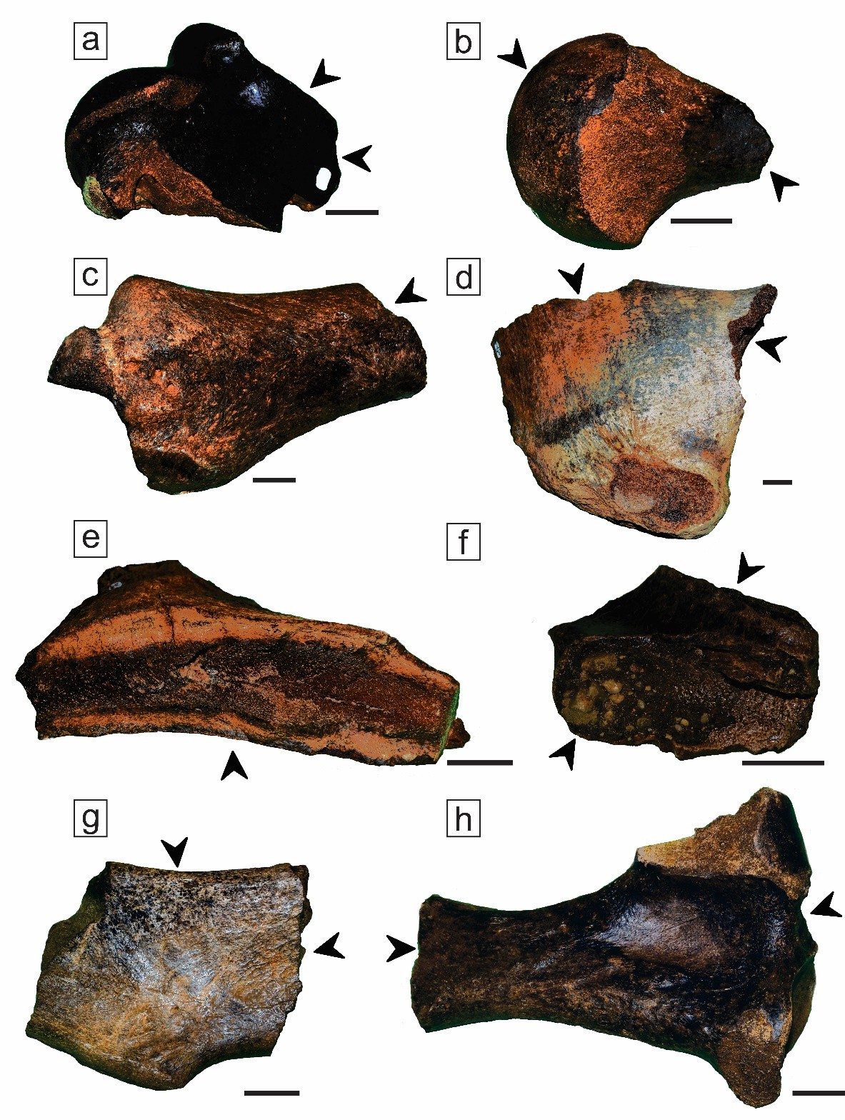
The fossils from the Apa River present taphonomic characteristics (Figure 10) similar to the fossils found in the Miranda and Formoso rivers (Oliveira, 2013; Pansani et al., 2016). They have in common a high degree of disarticulation, significant marks of breakage and abrasion with well-polished surfaces due to the type of transport. The predominantly black, yellowish and brown coloration that occurs at MABPS is also observed in the other two fluvial fossil outcrops in Mato Grosso do Sul. Among these sites, the occurrence of Notiomastodon platensis is restricted to the Apa River, while there is a record of Eremotherium laurillardi in the Miranda River. It is worth noting that the fossils from the Miranda and Formoso rivers were extracted by dredging, making taphonomic analysis difficult and selecting those with lower density and size.

Images of specimens of Eremotherium laurillardi (a-g) and Notiomastodon platensis (H) with arrows indicating taphonomic features. (A) CGP/2B58 – High degree of polishing and angular breakage; (b) CGP/2B61 – Abrasion marks and exposure of spongy tissue due to transport; (c) CGP/2B62 – Angular breakage and polishing; (d) CGP/2B63 – Linear breakage due to collection, polishing and high probability of atmospheric exposure post-fossilization; (E) CGP/2B64 – Linear breakage resulting from collection; (f) CGP/2B80 – Linear breakage and pebbles cemented laterally to the spongy tissue; (g) CGP/2B82 – Linear breakage, cementation of pebbles within the spongy tissue and probable precipitation of iron oxides; (h) CGP/2B79 – Linear breakage perpendicular to the diaphysis post-fossilization, nerve insertion cavities and indications of ichnological features.
The record of fragments of pelvic girdle, femur, humerus, ribs, tibia and skull of Eremotherium laurillardi and Notiomastodon platensis indicates short transport between the source area and the deposition site according to Groups II to III of the Fluvial Transport Index (FTI; Frison & Todd, 1986). Bones such as femur (Group III) are the samples with the lowest index of river transportability found in MABSP, followed by ribs (Group II), humerus (Group II) and tibia (Group II) with the highest indexes. Therefore, the burial plot is characterized as an assembly with a predominance of Group II, which indicates a concentration of bones that were transported from the place of death, but which were preserved in the original habitat of the organisms.
Tomassini et al. (2010) observed that the predominance in the fossil record of a more robust fauna and the near absence of those with an estimated body mass < 5 kg is directly associated with the river environment, due the reworking processes, transport and later deposition. This indicates a preservation bias of large taxa in fossil concentrations reworked by alluvial (tank deposits in Northeastern Brazil) and fluvial processes.
Furthermore, morphological studies of the jaw and stable isotope analysis of Eremotherium laurillardi fossils indicate a mixed diet, including C4 (herbaceous and grassy) and C3 (fruits and leaves) plants (Pansani et al., 2019). For this reason, some authors proposed that this taxon inhabited both open areas and forest edges (Macfadden, 2005; Dantas et al., 2013; França et al., 2014; Lobo et al., 2015; Dantas & Cozzuol, 2016; Pansani et al., 2019; Faria et al., 2020b). Similarly, N. platensis shows a generalist diet identified through studies of stable carbon isotopes, and may have inhabited forest edges, wooded savannahs, and savannahs (Mothé et al., 2013; Dantas et al., 2013; Faria et al., 2020b).
The record of megafauna fossils in current longitudinal bars is unprecedented in the state of Mato Grosso do Sul and little documented in South America literature. This occurrence of fossils in the Apa River indicates the possibility of new fossil deposits in other river bars. The research by Santos & Facincani (2006) has already delimited from a hydrogeomorphological perspective longitudinal gravel bars in the middle course of the Miranda River that are very similar to those found in the Apa River. In this circumstance, new perspectives are open for future paleontological investigation in river bars, such as the Miranda, Aquidauana and Formoso rivers, located in Mato Grosso do Sul State.
The presence of megafaunal taxa, such as Eremotherium laurillardi and Notiomastodon platensis, underscores the significance of this depositional environment in preserving elements of the Quaternary biota. The predominance of large, robust bones and the near absence of smaller-bodied taxa exemplify a preservation bias typical of fluvial and alluvial deposits, where hydraulic transport favors the accumulation of more massive skeletal elements.
5. CONCLUSION
The integration of geological, sedimentological, geomorphological, and taphonomic data from the Miguel Amaral Burgueño Site highlights the influence of fluvial dynamics on fossil accumulation and preservation within active river systems. The fossil assemblage, dominated by Eremotherium laurillardi and Notiomastodon platensis, records both the ecological composition of the Quaternary biota and the selective transport imposed by hydraulic processes. Taphonomic evidence, such as fragmentation and abrasion, indicates repeated reworking, although the preservation of elements with variable transport indices suggests short-distance transport within the Apa River system.
In contrast to most Brazilian megafaunal deposits, which are associated with inactive or alluvial contexts, the occurrence of fossils within a modern longitudinal bar represents a rare and significant finding. This emphasizes the importance of hydrogeomorphological settings in shaping depositional and preservational patterns, opening new possibilities for the recognition of similar fossiliferous contexts in other South American rivers.
The results provide a comparative framework for understanding bioclast accumulation in fluvial deposits and expand the known distribution of Quaternary megafauna in the Brazil–Paraguay border region. The site also offers new avenues for research on fossildiagenesis, paleoecology, and paleobiogeography, contributing to a more comprehensive understanding of Quaternary ecosystems in dynamic fluvial environments.
ACKNOWLEDGMENTS
To Mr. Paulo Burgueño, owner of Rancho Vô Pelufo, who collected and donated the first fossils found in the Apa River to the Federal University of Mato Grosso do Sul and demonstrated hospitality by welcoming researchers at the property headquarters during field expeditions. In recognition of Mr. Paulo Burgueño’s significant contribution and as a way of honoring his late son, the river bar where the fossils were found was named: Miguel Amaral Burgueño Paleontological Site.
This work was carried out with the support of the Coordination for the Improvement of Higher Education Personnel – Brazil (CAPES), under Process N°. 88887.175268/2025-00. Additionally, this study received funding from Fundação Carlos Chagas Filho de Amparo à Pesquisa do Estado do Rio de Janeiro, Brazil (Proc. E/26.048/2020, E-26/200.828/2021, and E-26/200.998/2024), as well as the Conselho Nacional de Desenvolvimento Científico e Tecnológico, Brazil (CNPq 303596/2016-3, 308900/2021-9).
-
Manuscript ID: 20250046.
-
How to cite:
Miranda-Junior, C. L. P., Faria, F. H. C., Facincani, E. M., Carvalho, I. S., & Iori, F. V. Taphonomic features in the Quaternary megafauna of the Apa River (Mato Grosso do Sul, Brazil). Braz. J. Geol. (2025), 55:e20250046. https://doi.org/10.1590/2317-4889e20250046
-
Financial support:
This work was carried out with the support of the Coordination for the Improvement of Higher Education Personnel – Brazil (CAPES), under Process N°. 88887.175268/2025-00. Additionally, this study received funding from Fundação Carlos Chagas Filho de Amparo à Pesquisa do Estado do Rio de Janeiro, Brazil (Proc. E/26.048/2020, E-26/200.828/2021, and E-26/200.998/2024), as well as the Conselho Nacional de Desenvolvimento Científico e Tecnológico, Brazil (CNPq 303596/2016-3, 308900/2021-9).
-
Data availability statement:
No use.
REFERENCES
- Alberdi, M. T., Cartelle, C., & Prado, J. L. (2002). El registro de Stegomastodon (Mammalia, Gomphotheriidae) en el Pleistoceno superior de Brasil. Revista Española de Paleontología, 17(2), 217-235.
- Ameghino, F. (1888). Rápidas diagnosis de algunos mamíferos fósiles nuevos de la República Argentina (pp. 469-480). Buenos Aires: Imprenta de Pablo Coni e Hijos.
-
Araújo-Júnior, H. I., Bissaro Júnior, M. C., Santos, T. T., Alves, R. S., & Bergqvist, L. P. (2012). Tafonomia da megafauna pleistocênica brasileira: Fluvial Transport Index (FTI) em análises de representatividade óssea. Revista Brasileira de Paleontologia, 15(1), 95-104. http://doi.org/10.4072/rbp.2012.1.08
» http://doi.org/10.4072/rbp.2012.1.08 -
Araújo-Júnior, H. I., Oliveira Porpino, K., & Bergqvist, L. P. (2017). Origin of bonebeds in Quaternary tank deposits. Journal of South American Earth Sciences, 76, 257-263. http://doi.org/10.1016/j.jsames.2017.03.012
» http://doi.org/10.1016/j.jsames.2017.03.012 -
Barbosa, F. H. S., Porpino, K. O., Araújo-Júnior, H. I., Bergqvist, L. P., & Rothschild, B. M. (2019). Articular and vertebral lesions in the Pleistocene sloths (Xenarthra, Folivora) from the Brazilian Intertropical Region. Historical Biology, 31(5), 544-558. http://doi.org/10.1080/08912963.2017.1376191
» http://doi.org/10.1080/08912963.2017.1376191 -
Behrensmeyer, A. K. (1978). Taphonomic and ecologic information from bone weathering. Paleobiology, 4(2), 150-162. http://doi.org/10.1017/S0094837300005820
» http://doi.org/10.1017/S0094837300005820 - Brasil. (1982). Projeto RADAM Brasil (Vol. 28, 412 p.). Rio de Janeiro: Secretaria Geral, Ministério das Minas e Energia.
- Cartelle, C. (1999). Pleistocene mammals of the Cerrado and Caatinga of Brazil. In J. F. Eisenberg & K. H. Redford (Eds.), Mammals of the Neotropics (p. 27-46). Chicago: The University of Chicago Press.
- Cartelle, C. (2000). Preguiças terrícolas, essas desconhecidas. Ciência Hoje, 27(161): 18-25.
-
Cartelle, C., & De Iuliis, G. (1995). Eremotherium laurillardi: The Panamerican Late Pleistocene Megatheriid Sloth. Journal of Vertebrate Paleontology, 15(4), 830-841. http://doi.org/10.1080/02724634.1995.10011265
» http://doi.org/10.1080/02724634.1995.10011265 - Christofoletti, A. (1980). Geomorfologia (188 p.). São Paulo: Blucher.
- Dantas, M. A. T., Missagia, R., Dutra, R., Raugust, T., Silva, L. A., Delicio, M. P., & Renó, R. (2013). Identificação taxonômica dos fósseis de mamíferos da Caverna Toca Fria e Jatobá, Iuiú, Bahia: Inferências paleoecológicas e temporais. In Anais do 32° Congresso Brasileiro de Espeleologia (pp. 433-338), Barreiras, BA. SBE.
- Dantas, M. A. T., & Cozzuol, M. A. (2016). The Brazilian Intertropical Fauna from 60 to about 10 KA B.P.: Taxonomy, dating, diet and paleoenvironments. In G. Gasparini, J. Rabassa, E. P. Tonni & C. Deschamps, C. (Ed.), Marine isotope stage 3 in southern South America, 60 KA B.P.-30 KA B.P. (pp. 207-226). Cham: Springer.
-
European Space Agency – ESA. (2024). Copernicus Space Component Data Access PANDA catalogue.https://panda.copernicus.eu/web/cds-catalogue/panda
» https://panda.copernicus.eu/web/cds-catalogue/panda - Faria, F. H. C. (2016). Análise tafonômica dos fósseis da megafauna quaternária do Lajedão do Patrício, João Dourado, Bahia, Brasil [Dissertação de mestrado]. Instituto de Geociências, Universidade Federal do Rio de Janeiro.
-
Faria, F. H. C., Kinoshita, A., Carvalho, I. S., Araújo-Júnior, H. I., Pegorin, P., Figueiredo, A.M., & Baffa, O. (2020a). ESR dating of late Quaternary megafauna fossils from João Dourado, Bahia, Brazil. Journal of South American Earth Sciences, 101, 1-7. http://doi.org/10.1016/j.jsames.2020.102586
» http://doi.org/10.1016/j.jsames.2020.102586 -
Faria, F. H. C., Carvalho, I. S., & Araújo-Júnior, H. I. (2020b). Genesis and taphonomic biases of Quaternary tank deposits of northeastern Brazil. Quaternary International, 550, 184-193. http://doi.org/10.1016/j.quaint.2020.04.045
» http://doi.org/10.1016/j.quaint.2020.04.045 -
Faria, F. H. C., Souza Carvalho, I., Araújo-Júnior, H. I., Ximenes, C. L., & Facincani, E. M. (2025). 3,500 years BP: The last survival of the mammal megafauna in the Americas. Journal of South American Earth Sciences, 153, 105367. http://doi.org/10.1016/j.jsames.2025.105367
» http://doi.org/10.1016/j.jsames.2025.105367 -
França, L. M., Asevedo, L., Dantas, M. A. T., Bocchiglieri, A., Avilla, L. S., Lopes, R. P., & Silva, J. L. L. (2014). Review of feeding ecology data of Late Pleistocene mammalian herbivores from South America and discussions on niche differentiation. Earth-Science Reviews, 140, 158-165. http://doi.org/10.1016/j.earscirev.2014.10.006
» http://doi.org/10.1016/j.earscirev.2014.10.006 - Frison, G. C., & Todd, L. C. (1986). The Colby Mammoth Site: Taphonomy and archaeology of a Clovis Kill in Northern Wyoming (238 p.). Albuquerque: University of New Mexico Press.
-
Gallo, V., Avilla, L. S., Pereira, R. C., & Absolon, B. A. (2013). Distributional patterns of herbivore megamammals during the Late Pleistocene of South America. Anais da Academia Brasileira de Ciências, 85(2), 533-546. http://doi.org/10.1590/S0001-37652013000200005 PMid:23828364.
» http://doi.org/10.1590/S0001-37652013000200005 - Grotzinger, J., & Jordan, T. (2008). Para entender a terra (6. ed.). Porto Alegre: Bookman.
- Kerber, L., & Oliveira, E. V. (2008). Fósseis de vertebrados da Formação Touro Passo (Pleistoceno Superior), Rio Grande do Sul, Brasil: Atualização dos dados e novas contribuições. Gaea Journal of Geoscience, 4(2), 49-64.
- Happ, S. C., Rittenhouse, G., & Dobson, G. C. (1940). Some principles of accelerated stream and valley sedimentation Washington, D.C.: U.S. Department of Agriculture.
-
Instituto Nacional de Pesquisas Espaciais – INPE. (2025a). Catálogo de Imagens.https://www.dgi.inpe.br/catalogo/explore
» https://www.dgi.inpe.br/catalogo/explore -
Instituto Nacional de Pesquisas Espaciais – INPE. (2025b). TOPODATA.http://www.dsr.inpe.br/topodata/
» http://www.dsr.inpe.br/topodata/ - Lacerda Filho, J V., Brito, R., Silva, M., Oliveira, C., Moreton, L., Martins, E., Lopes, R., Lima, T., Larizzatt, J., & Valente, C. (2006). Geologia e recursos minerais do estado de Mato Grosso do Sul. Campo Grande: CPRM.
-
Lobo, L. S., Scherer, C. S., & Dantas, M. A. T. (2015). Megafauna do Pleistoceno final de Matina, Bahia, Brasil: Sistemática, cronologia e paleoecologia. Revista Brasileira de Paleontologia, 18(2), 325-338. http://doi.org/10.4072/rbp.2015.2.11
» http://doi.org/10.4072/rbp.2015.2.11 - Lund, P. W. (1842). Blik paa Brasiliens Dyreverden för sidste Jordomvaeltning. Fjerde Afhandling: Forstsaettelse af Pattedyrene. Danke Vidensk Selsk, 9, 137-209.
-
Macfadden, B. J. (2005). Diet and habitat of toxodont megaherbivores (Mammalia, Notoungulata) from the late Quaternary of South and Central America. Quaternary Research, 64(2), 113-124. http://doi.org/10.1016/j.yqres.2005.05.003
» http://doi.org/10.1016/j.yqres.2005.05.003 - Magalhães Júnior, A. P., & Barros, L. F. P. (2020b). Depósitos fluviais e feições deposicionais. In A. P. Magalhães Júnior & L. F. P. Barros (Eds.), Hidrogeomorfologia: Formas, processos e registros sedimentares fluviais (1. ed., pp. 259-295). Rio de Janeiro: Bertrand Brasil.
- Manes, M. I. L. (2019). Contexto geológico e paleontológico das pegadas fósseis (Formação Botucatu) na região de Nioaque, Mato Grosso do Sul: Subsídios para a geoconservação [Dissertação de mestrado]. Universidade Federal do Rio de Janeiro.
-
Martinelli, A. G., Ferraz, P. F., Cunha, G. C., Cunha, I. C., Carvalho, I. S., & Ribeiro, L. C. B. (2012). First record of Eremotherium laurillardi (Lund, 1842) (Mammalia, Xenarthra, Megatheriidae) in the Quaternary of Uberaba, Triângulo Mineiro (Minas Gerais State), Brazil. Journal of South American Earth Sciences, 37, 202-207. http://doi.org/10.1016/j.jsames.2012.03.006
» http://doi.org/10.1016/j.jsames.2012.03.006 - Mothé, D. (2012). Revisão taxonômica dos gonfóteros quaternários (Mammalia: Proboscidea: Gomphotheriidae) das planícies sul-americanas. Quaternário Internacional, 276, 2-7.
-
Mothé, D., Avilla, L. S., & Cozzuol, M. A. (2013). The South American Gomphotheres (Mammalia, Proboscidea, Gomphotheriidae): Taxonomy, phylogeny, and biogeography. Journal of Mammalian Evolution, 20(1), 23-32. http://doi.org/10.1007/s10914-012-9192-3
» http://doi.org/10.1007/s10914-012-9192-3 - Oliveira, A. M. (2013). Paleofauna de vertebrados, com ênfase em répteis e mamíferos, dos depósitos quaternários da região da Serra da Bodoquena, Mato Grosso do Sul, Brasil [Dissertação de mestrado]. Universidade Estadual Paulista “Júlio de Mesquita Filho”.
-
Pansani, T. R., Muniz, F. P., Cherkinsky, A., Pacheco, M. L. A. F., & Dantas, M. A. T. (2019). Paleoecologia isotópica (δ13C, δ18O) da megafauna do quaternário tardio dos estados de Mato Grosso do Sul e Bahia, Brasil. Quaternary Science Reviews, 221, 105864. http://doi.org/10.1016/j.quascirev.2019.105864
» http://doi.org/10.1016/j.quascirev.2019.105864 -
Pansani, T. R., Oliveira, A. M., & Pacheco, M. L. A. F. (2016). Nova ocorrência de megafauna pleistocênica em Mato Grosso do Sul. Revista do Instituto Geológico, 37(2), 73-85. http://doi.org/10.5935/0100-929X.20160010
» http://doi.org/10.5935/0100-929X.20160010 - Paula-Couto, C. (1979). Tratado de Paleomastozoologia (590 p.). Rio de Janeiro: Academia Brasileira de Ciências.
-
Prado, J. L., Alberdi, M. T., Azanza, B., Sánchez, B., & Frassinetti, D. (2005). The Pleistocene Gomphotheriidae (Proboscidea) from South America. Quaternary International, 126, 21-30. http://doi.org/10.1016/j.quaint.2004.04.012
» http://doi.org/10.1016/j.quaint.2004.04.012 - Prado, J. L., Alberdi, M. T., Azanza, B., Sánchez, B., & Frassinetti, D. (2001). The Pleistocene Gomphotheres (Proboscidea) from South America: Diversity, habitats and feeding ecology. In The World of Elephants - International Congress (pp. 337-340), Rome.
- Rodrigues, J. M., Facincani, E. M., Bazhuni, B. A., Sanches, L. F. J., Cunha, F. J. G., & Queiroz, R. M. (2021). Diversidade de mamíferos fósseis de grande porte do quaternário na porção sudoeste do estado de Mato Grosso do Sul. Revista Pantaneira, 19, 95-110.
- Salles, L. O. (2006). Quaternary mammals from Serra da Bodoquena, Mato Grosso do Sul, Brazil. Boletim do Museu Nacional, (521), 12.
- Santos, J. D., & Facincani, E. (2006). O médio vale do rio Miranda sob a óptica da geomorfologia fluvial. Revista Pantaneira, 8(1), 28-36.
- Shipman, P. (1981). Life history of a fossil: An introduction to taphonomy and paleoecology. Chicago: Harvard University Press.
- Silva, T. M. (2007). Mapeamentos geomorfológicos: Escalas, aplicações e técnicas de compartimentação do relevo. Geo Uerj, 1(17), 70-94.
- Stevaux, J. C., & Latrubesse, E. (2017). Geomorfologia fluvial. São Paulo: Oficina de Textos.
-
Tomassini, R. L., Montalvo, C. I., Manera, T., & Oliva, C. (2010). Estudio tafonómico de los mamíferos pleistocenos del yacimiento de Playa del Barco (Pehuen Co), provincia de Buenos Aires, Argentina. Ameghiniana, 47(2), 137-152. http://doi.org/10.5710/AMGH.v47i2.5
» http://doi.org/10.5710/AMGH.v47i2.5 -
Tomassini, R. L., & Montalvo, C. I. (2013). Taphonomic modes on fluvial deposits of the Monte Hermoso Formation (early Pliocene), Buenos Aires province, Argentina. Palaeogeography, Palaeoclimatology, Palaeoecology, 369, 282-294. http://doi.org/10.1016/j.palaeo.2012.10.035
» http://doi.org/10.1016/j.palaeo.2012.10.035 -
Trifilio, L. H. M. S., Araújo Júnior, H. I., & Oliveira Porpino, K. (2024). Taphonomic histories of Quaternary fossil accumulations preserved in Brazilian cave deposits. Journal of South American Earth Sciences, 148, 105168. http://doi.org/10.1016/j.jsames.2024.105168
» http://doi.org/10.1016/j.jsames.2024.105168 -
U.S. Geological Survey – USGS. (2025). Earth Explorer.http://earthexplorer.usgs.gov
» http://earthexplorer.usgs.gov -
Woodburne, M. O. (2010). The great American biotic interchange: Dispersals, tectonics, climate, sea level and holding pens. Journal of Mammalian Evolution, 17(4), 245-264. http://doi.org/10.1007/s10914-010-9144-8 PMid:21125025.
» http://doi.org/10.1007/s10914-010-9144-8
Edited by
-
SCIENTIFIC EDITOR:
Carlos Henrique Grohmann http://orcid.org/0000-0001-5073-5572
-
ASSOCIATE EDITOR:
Lucas Verissimo Warren https://orcid.org/0000-0002-2050-6514
No use.