
 THE CONCEPT OF CARTOGRAPHY, DEFINITIONS FROM 1960 TO 2000
Abstract
from the 1940s to 2000, reflecting on the conceptual transformations in the field and their relationship with technological advancements. Initially, the UN provided the definition of Cartography, but from 1965 onwards, the ICA assumed this responsibility. Over the span of 40 years, these definitions evolved considerably. In 1992, Fraser Taylor, as the president of the ICA, introduced a significant update by incorporating the term "geoinformation" into the definition. This modification broadened the scope of Cartography to include other forms of spatial representation. However, in the late 1990s, there was a regression when the ICA simplified the definition of Cartography, restricting it to the study of maps. This dynamic illustrates that the evolution of scientific debates does not always follow a linear trajectory, often oscillating between advancements and regressions. Consequently, it is concluded that ongoing conceptual debates around the definition of Cartography are essential to keep pace with emerging technological and theoretical innovations in the field.
Keywords:
Epistemology; International Cartographic Association; History of Cartography
Resumo
Este artigo analisa as definições de Cartografia propostas pela ONU (Organização das Nações Unidas) e pela ICA (International Cartographic Association) entre os anos 1940 e 2000, refletindo sobre as transformações conceituais no campo e sua relação com os avanços tecnológicos na área. Inicialmente, a definição de Cartografia era determinada pela ONU, mas a partir de 1965, a ICA assumiu essa responsabilidade. Ao longo de 40 anos, as definições evoluíram consideravelmente. Em 1992, Fraser Taylor, como presidente da ICA, apresentou uma atualização significativa ao incluir o termo "geoinformação" em sua definição. Essa modificação ampliou o escopo da Cartografia para abranger outras formas de representação espacial. No entanto, no final da década de 1990, houve um retrocesso quando a ICA simplificou a definição de Cartografia, restringindo-a ao estudo de mapas. Essa dinâmica mostra que a evolução dos debates científicos nem sempre segue uma trajetória linear, podendo oscilar entre avanços e retrocessos. Portanto, conclui-se que é essencial continuar os debates conceituais em torno da definição da Cartografia para acompanhar as inovações tecnológicas e teóricas emergentes no campo.
Palavras-chave:
Epistemologia; Associação de Cartografia Internacional; História da Cartografia
Resumen
Este artículo analiza las definiciones de Cartografía propuestas por la ONU (Organización de las Naciones Unidas) y por la ICA (International Cartographic Association) entre los años 1940 y 2000, reflexionando sobre las transformaciones conceptuales en el campo y su relación con los avances tecnológicos en el área. Inicialmente, la definición de Cartografía era determinada por la ONU, pero a partir de 1965, la ICA asumió esa responsabilidad. A lo largo de 40 años, las definiciones evolucionaron considerablemente. En 1992, Fraser Taylor, como presidente de la ICA, presentó una actualización significativa al incluir el término "geoinformación" en su definición. Esta modificación amplió el alcance de la Cartografía para abarcar otras formas de representación espacial. Sin embargo, a finales de la década de 1990, hubo un retroceso cuando la ICA simplificó la definición de Cartografía, restringiéndola al estudio de mapas. Esta dinámica muestra que la evolución de los debates científicos no siempre sigue una trayectoria lineal, pudiendo oscilar entre avances y retrocesos. Por lo tanto, se concluye que es esencial continuar los debates conceptuales en torno a la definición de la Cartografía para acompañar las innovaciones tecnológicas y teóricas emergentes en el campo.
Palabras-clave:
Epistemología; Asociación Cartográfica Internacional; Historia de la Cartografía
INTRODUCTION
While conducting scientific research, it is essential to clearly establish the definition of the terms and concepts used throughout the study. This need is imposed on the researcher in order to elucidate his intentions and ease the reader's understanding of the text. Presenting concepts and definitions accurately is ultimately also an ethical practice in research. This is because the scientific field is marked by debates between different authors' conceptions, cultures and scientific communities' traditions, which directly influence the definitions of concepts and how reality is understood (KUHN, 2017).
Authors such as Thomas Kuhn (2017), and even Popper (1996, 2014), have reflected deeply on this process. They also stand out as emblematic examples of disputes in the academic world. When proposing theoretical reviews on the same object of study, which is how scientific knowledge evolves, these authors present significant divergences concerning the definition of concepts and processes in their own analyses. However, these disputes are not unique to the field of scientific theory. The stories of debates and quarrels between the Greek philosophers Diogenes and Plato are famous. Moving forward in time, the quarrels between Leonardo da Vinci and Michelangelo in Italy are immortalized in works, monuments and letters between the two. In the field of Exact Sciences, Thomas Edison and Nikola Tesla, in the nineteenth and twentieth centuries, were staunch opponents both in the sciences and in the public sphere. In the field of Geosciences, a striking example in geography is the divergent ideas of Vidal de la Blache and Friedrich Ratzel.
Amid these disputes, it is crucial to consider how social factors influence the construction of concepts and how they are applied. Societies do science in an attempt to solve the challenges they face in their daily lives, because doing science is, in essence, working on solving problems caused by human curiosity (BAZARIAN, 1985). In this perspective, Thomas Kuhn (2017) argues that the catalyst for the evolution of scientific knowledge is these social transformations. When a scientific approach, which previously offered answers to society's problems, begins to accumulate flaws over time, a crisis in knowledge occurs, demanding a revision of concepts and practices.
Cartography, as a field of knowledge, is not immune to such needs for conceptual transformation. In the last 60 years, the concept of cartography has undergone several formulations and reformulations as a result of the maturation of the field and its researchers, as well as the needs of society concerning spatial representation. In addition, it is important to consider that this movement was strongly influenced by the advancement of geospatial technologies after World War II, which directly impacted how maps were produced and, above all, the reasons for making them.
Currently, the most recent official definition of cartography established by the International Cartographic Association (ICA) is present in “A Strategic Plan For the International Cartographic Association 2003-2011" and in a prominent place on the institution's website, as highlighted by Polous (2024). However, it is necessary to question which were the paths taken by cartography and the influences of related fields that have contributed to the construction of this definition. In this sense, this article aims to explore the evolution of the concept of cartography, focusing on the debates that took place within the International Cartographic Association (ICA) between the years 1960 and 2000. It will be highlighted how the influence of broader factors contributed to these debates around the concept of cartography.
THE 1960S - CARTOGRAPHY IS ALSO A FORM OF ART
In the post-war period, the "official" definition of cartography was initially stipulated by the United Nations (UN), which presented it as follows: “According to a former definition of the United Nations, the science of cartography covers the preparation of all types of maps and plans and includes all operations from original field surveys to final printing of copies "(BROMMER, 1969, p. 14).
The definition stipulated by the UN was more focused on the elaboration and distribution of topographic charts, related to the production of the so-called base cartography. However, this limited definition excluded a large part of the so-called thematic cartography, produced by other scientific fields, as well as historical cartographic products (BROMMER, 1969).
However, since the 60s, the International Cartographic Association (ICA) has become the officially constituted body to discuss aspects related to cartography, such as its definition, function and application. For what has been almost 70 years, the definition of cartography has not remained static within the institution, incorporating over time the influences of the evolution of society and technological advances.
Thus, already in 1965, aware of the limitations of the definition of cartography presented by the UN, the ICA sought to establish its first new definition of what cartography is. In this new perspective, it was understood that cartography would be art, science and technology, according to the following definition:
The art, science and technology of making maps, together with their study as scientific documents and works of art. In this context maps may be regarded as including all types of maps, plans, charts and sections, three dimensional models and globes, representing the earth or any heavenly body at any scale (BROMMER, 1969 p.14).
Thus, when comparing the definitions of the UN and the one presented by the ICA in 1965, an expansion of the scope of action of cartography can be perceived. The inclusion of scientific documents, works of art, and other forms of representation of celestial bodies, including the Earth, has expanded the materials that can be produced or analysed by cartography. This new approach also broadened the temporal window of cartographic analyses, incorporating representations that predate the more traditional idea of maps in modern cartography and the materials from which they could be made, such as works of art and the cartographies of traditional peoples (Figure 1).

a. Example of traditional cartography from Oceania; b. Example of traditional North American cartography; c. Example of traditional Mesoamerican cartography; d. Example of traditional cartography of the peoples of Eurasia and the Arctic. Source: Adapted from Woodward and Lewis (1998), Whitridge (2004), Genz (2016), and Franco (2019).
The need to include the idea of Cartography as a form of art also arose from the difficulty, during certain periods of cartographic production, in distinguishing the cartographer from the artist (BROMMER, 1969). Prominent Renaissance painters such as Da Vinci, Michelangelo, and Galileo were responsible for creating maps that were significant during the Age of Exploration. This movement not only incorporated other forms of European Cartography representation (artworks, engravings, etc.) but also encompassed Cartography produced by other cultures around the world, which also deviated from the standard ideals of Cartography, maps, and spatial representation (Figure 1).
Concerning the demand to consider cartography as art, Gomes (2017) highlights how a new imagetic culture was progressively built in society after the fifteenth century. In this culture, maps made by geographers and cartographers were not only valued for their geo-informational content, but also as an aesthetic product and symbol of status and power in European society.
Ribeiro and Caquard (2018, p. 2) also discuss the conception of the map (and consequently cartography) as an art form. To the authors, the 15th century was marked by a change, and "in parallel with this shift towards a scientific paradigm, maps started to make their way into artistic expressions.", influencing the way cartography would be built from that moment on while also partially becoming an aesthetic product.
Taylor (1991) also shares the same view of cartography as art. With a slightly more philosophical approach, he points out that the complexity of the world requires the cartographer to have the ability to build maps as a form of communication. Thus, to ensure elegance and clarity in the transmission of geoinformation, it is essential that the cartographer, in addition to mastering the techniques of formal mapping, possess a keen aesthetic sense, transforming him into a kind of artist.
Thus, faced with all these factors, the ICA realized the need to broaden the understanding of cartography also as an art form, in order to consider the production and evolution of historical cartography. These ancient maps had not only geographical value, but also historical, cultural, aesthetic and even legal, given that some treaties and border delimitations still in force were drawn based on these ancient maps. Therefore, the first definition of cartography established by the ICA extended the temporal and spatial boundaries of cartographic analysis in a way that had not been done until now.
FROM 1970 TO 1980 - THE NEED TO CONSIDER NEW TECHNOLOGIES IN THE DEFINITION OF CARTOGRAPHY.
Although the ICA definition of cartography from 1965 represented a breakthrough for the area, subsequent transformations over the years have had impacts on how cartography is perceived. This would result in the need to reformulate the concept of cartography again a few decades later.
Thus, the definition of cartography presented by the ICA in 1965 would be questioned by Ormeling (1980), 15 years after its establishment. To the author, the definition from the 1960s was limited, leaving out much of the production and spatial analysis carried out by other areas of knowledge. In addition, it was not able to encompass the innovations and techniques applied to mapping that emerged in this period:
In the practical application of this definition, the gathering of primary data, field surveying, and photogrammetry are excluded as are surveys carried out by other disciplines such as geology, statistics, demography, etc. Cartography thus limited to "cartography proper," i.e., the design and construction of maps and charts up to the stage where they are processed by a printer (ORMELING, 1980, p. 5).
Ormeling continues, arguing that the previous so-called narrow definition used by the UN was actually broader than the one created by the ICA. According to him, this definition resulted in a greater practical value for the application of cartography in everyday life:
The United Nations uses a much wider definition of the field, dating from 1948, according to which cartography is the science of surveying and mapping and embraces all phases of mapping from data collection to data processing and data presentation.Thus, it includes surveying, aerial photography, topography, toponymy, and photogrammetry, as well as the activities included in the ICA definition. (ORMELING, 1980, p. 5).
Between Ormeling's (1980) critiques and Brommer's (1969) remarks on the definition from 1965, it is clear that both have distinct interpretations of the impact of the UN's 1948 and ICA's 1965 definitions of cartography. However, these differences are justified by the fact that, even though both visions are separated by seemingly only a few decades, there is a great abyss of technological and social innovations between them, which partly justifies Ormeling's (1980) criticism of the ICA's decisions concerning the concept of cartography.
Throughout the 1960s and 1970s, society experienced several technological advances that were also incorporated into cartography (Table 1). The Space Race, in particular, prompted significant leaps in data acquisition and monitoring techniques, being a period of rapid evolution in the construction of space and airborne sensors, which facilitated new perspectives for Earth observation and the carrying out of space analysis in various areas. In this same period, there was also significant development in computers and software tailored for technical drawing and Cartography, contributing to increased productivity and efficiency in map creation.
Synthesis of some technological advances incorporated into cartography throughout the 1960s and 1980s. Source: Elaborated by the authors (2024).
The influence of the emergence of the first computer-aided design (CAD) programs in the early 1960s on map production is unquestionable. Considered as an initial milestone of this process, the creation "Sketchpad", developed by Ivan Sutherland (TORNINCASA; MONACO, 2010), is considered the first CAD in history. With the adoption of these CAD programs and their incorporation into Geographic Information Systems (GIS) for the elaboration of maps, it was possible to streamline the process of drawing and correcting the plans, maps, and charts, resulting in considerable gains in accuracy in cartographic documents (TOMLINSON, 1988).
Within this context of interdisciplinary innovations that influenced cartography, which were the basis of Ormeling's (1980) remarks on the concept of Cartography, the family of satellites Landsat was already in its third generation in the 80s, and the Global Positioning System (GPS) was in operation since 1978. Both provided a new form of data collection and geolocation of events on the planet's surface. Not long after the Americans, the Soviet project Resurs 1, with a proposal similar to the Landsat, came into operation in the 1970s, while the GLONASS began its activities throughout the 80s.
Analysing from this perspective, the technological innovations that emerged in that period, among several others, justify the criticism of Ormeling (1980) on the need to incorporate the cartographic data and products produced by these new geotechnologies into the definition of cartography. As such tools were already being applied in cartographic production.
His criticism also supported his defence for considering cartographic products produced by other fields of knowledge as an integral part of cartography. With the technological innovations described, other fields of science began to explore new possibilities of spatial studies and analysis, expanding their areas of investigation using cartography.
However, as valid as the author's criticisms are considering the context of the time, it is important to emphasize that the ICA, when defining the cartography in 1960, could not predict or incorporate events that would occur over the next 20 years. Thus, the considerations of Ormeling (1980), although relevant to the reality of cartography at that time, suffer from a certain historical anachronism1 .
Faced with the new cartographic needs and scopes of activity at the beginning of the 80s, along with the emerging criticisms, not only from Ormeling (1980), that multiplied, the ICA evaluated its situation and reformulated its definition of cartography. The new orientation was as it follows:
Cartography is the totality of scientific, technical and artistic activities aiming at the production of maps and related presentations on the basis of data (field measurements, aerial photographs, satellite imagery, statistical material, etc.) collected by other disciplines. Further, Cartography includes the study of maps as scientific documents as well as their use (ICA, 1980, p. 53).
In this update, the ICA managed with mastery to preserve the advances highlighted by Brommer (1969), recognizing the artistic and historical character of the maps, while at the same time meeting the criticisms, especially those of Ormeling (1980). Thus, the ICA also began to admit that cartography could be done by other areas of knowledge and included in its definition the use of new geotechnical tools that were transforming the ways of producing maps and other spatial representations.
However, technological evolution accelerated in the following decades, transforming once more the ability to process and visualize spatial data and information. More importantly was how people started to interact with technology on a daily basis. These changes also influenced cartography, requiring once again a conceptual reformulation of the field.
THE 1980S AND 1990S - THE ACCELERATION OF TECHNOLOGICAL CHANGES AND THE NEED FOR A NEW DEFINITION OF CARTOGRAPHY.
The first definition established by the ICA remained for 15 years, from 1965 to 1980. However, during this period, the accelerated technological development further impacted cartographic productions, substantiating the need for a new definition. In this sense, throughout the 80s, technologies continued directly influencing how cartography was conducted. At that time, these transformations also began to affect in a deeper way how society consumed maps.
This second set of technological transformations around cartography in the 80s can be directly related to the advancement of Geographic Information Systems (GIS), as well as to the improvement in computer processing systems and the evolution of their interfaces.
Although SIG had been present since the 60s, with the CGIS (SILVA, 2003; CÂMARA and DAVIS, 2004; ZAIDAN, 2017; ROCHA, 2019), the interfaces of these systems were still complex and demanded large data centers to meet their basic operating requirements, which resulted in a slow learning curve for the professionals who operated them.
Regarding this transformation in GIS, Silva (2007) clearly illustrates how computer systems evolve over time. To the author, while the complexity in the construction of programs and equipment increases, the difficulties in using them are reduced and the experience of users with the interface is improved (Figure 2). Therefore, within the scope of GIS and map production, all the aforementioned factors converged, considerably reducing map production costs, and expanding the process of creating and updating cartographic documents.

Relationship between the complexity of the use of the program and the complexity of computer systems according to the evolution of computing, whose evolution also reduces the cost of equipment. Source: Adapted from Silva (2003).
The impacts of this process, which showed more prominent results in the 90s, were already outlined in the 80s, marked by a significant improvement in computer systems and their equipment aimed at creating graphical interfaces. In 1981, IBM released Acorn, a personal computer with an operating system developed by the then young Microsoft, or MS-DOS. This equipment was relatively small compared to its predecessors and featured a graphical interface with a coloured screen, originating the idea of a personal computer (PC).
In 1984, Apple would also launch the Macintosh, along this same line of conception of personal computers. It was the first PC with an interface that had icons to launch programs and a mouse, providing a better interaction experience between user and machine. The following year, Microsoft created the Windows, the operating system that would go on to be one of the most widely used across the world to this day.
The innovations introduced by these companies allowed for a new approach in dealing with computers, directly resulting in greater accuracy and efficiency in the construction of maps through GIS. In this new scenario, although they still existed, large data centres were no longer essential for digital cartography. The new interfaces also drove an increase in processing capacity, mainly due to improvements in Intel's integrated chips. These advances were key to dealing with the new data sets that were emerging in large volumes from new data collection equipment, such as satellite imagery, radar or airborne sensors.
Amid this transformation of how GIS and Digital cartography redefined the production and consumption of maps, the impact of the Environmental Systems Research Institute (ESRI) in the area is undeniable. Founded in 1969, the ESRI redirected in the 80s its efforts into developing software solutions aimed at the treatment and analysis of georeferenced data, as well as producing maps (ESRI, 2011). As a result of this new approach, the company launched in the late 80s the platform ARC / INFO (ESRI, 2011). The success of the ESRI's applications has been enormous thanks to the easily operated platform and the creation of universal file format standards for geoprocessing and digital mapping, as is the case with the format shapefile, which is still widely used today.
In the early 90s, the ESRI launched ArcView, a more accessible desktop mapping tool with an even better user learning curve (ESRI, 2011). This transformation was also linked to the development of Windows NT and later Windows 95. These operational systems introduced a new dynamic between user and computer, a model that remains to this day and has been adapted to the practices of geoprocessing and digital cartography software. In addition to the ESRI's efforts, technological developments in this period made it possible for other forms of map production and distribution to emerge. With the popularization of more reliable storage systems, such as CD-ROM and DVD-R, the sharing of databases, software and maps expanded significantly. An innovation of the time was the creation of interactive maps and atlases in applications inside CDs and DVDs (ANDREWS, 1994) that allowed users to experience greater interactivity with the geoinformation present there. Figure 3 and Figure 4 present some examples from this period highlighted by Andrews (1994) as an innovative approach to cartography.

"Archive of North American Indian Maps on CD-ROM" is an example of an interactive map featured in CDs and DVDs popular in the 90s. Source: Adapted from Andrews (1994).

"African Maps” is another example of interactive maps featured in CDs and DVDs popular in the 1990s highlighted by Andrews (1994). Source: Adapted from Andrews (1994).
With the advance of the protocol World Wide Web (WWW) and the emergence of the modern Internet, the demand for georeferenced data and maps for everyday use grew significantly and started to be digitally supplied (CAMMACK, 1999; PETERSON, 2006). Digital maps began to be used on a recurring basis by government agencies and civil society. Consequently, sites for sharing maps on the web became increasingly common, as did navigation systems. One of the successful examples of this period was a type of "interactive atlas" produced by GeoSystems Global Corporation, called MapQuest (Figure 5), a precursor of Google Maps or Waze, present in smartphones currently.

Appearance of MapQuest in the 90s, demonstrating what the navigation system was like through digital maps. Source: Kent (2015).
During the 90s, with the expansion and consolidation of the dematerialization of georeferenced information, cartography faced a dilemma in the face of emerging geotechnologies: the risk that mapping techniques outweighed the importance of cartography as a science. According to Taylor (1991), it was necessary to consider the impacts of new technologies on cartography, but not to reduce the field only to these advances:
The scientific technology of cartography is important but in my view the issues which should determine new directions for cartography are not primarily technical. Indeed, it can be argued that if the prevailing technological paradigm is allowed to predominate then much will be lost. To allow our understanding and definition of cartography to be determined by a technological imperative would be a mistake. (TAYLOR, 1991, p. 1)
In other words, to Taylor (1991), cartographers would be able to absorb new technologies very well and would even be enthusiastic about the novelties. However, there was great difficulty in developing the necessary conceptual basis for its full potential use in cartography. In this sense, Taylor (1991) understood that maps had always been able to answer the question “where?” but, in the near future, should offer answers to:
(...) a variety of other questions such as 'why', 'when', and 'by whom' and 'for what purpose', and must convey to the user an understanding of a much wider variety of topics than was previously the case (TAYLOR, 1991, p. 3)
Thus, in order to reduce the focus on the overestimation of data collection and processing technologies, Taylor (1991) proposes a definition that emphasizes cartography as a means of communication. This effort was necessary to avoid reductionisms that exalted only technical means or computational tools, which are ephemeral and constantly evolving, compared to cartography as a field of knowledge.
Thus, according to Taylor (1991), cartography is the field of knowledge that addresses “The organization, presentation, communication and utilization of geo-information in graphic, digital or tactile form. It can include all stages from data presentation to end use in the creation of maps and related spatial information products" (TAYLOR, 1991, p. 4).
The definition proposed by Taylor in the early 90s was aligned with the needs of cartography in that period, without neglecting the contributions of the past. Therefore, when considering the observations of Castiglione (2009) that geoinformation accompanies humanity from its beginnings and has been transformed until the present moment, where its digitalization (or 'dematerialization') occurred, Taylor (1991) elaborated a definition of cartography that encompasses all cartographic production already carried out and the future forms that would still be developed, establishing a connection of cartography with geoinformation.
By stating that cartographic (or geoinformation) production can take "graphic, digital or tactile form(s)" (TAYLOR, 1991, p. 4), the concept of cartography is also extended beyond cartographic documents on paper or similar. This allows for other forms of representation to be recognised, whether historical, such as clay pieces and cave engravings, etc. (Figure 1), or contemporary, such as digital maps and Web GIS (Figures 3 and 4).
Therefore, as put by Menezes and Ávila (2005, p. 9115), even today, the definition proposed by Taylor (1991) on cartography is, in reality:
[...] one of the most up-to-date definitions, incorporating concepts that were not previously considered, but in the present day are practically already directly associated with cartography. It extrapolates the concept of cartographic presentation, due to the evolution of the means of presentation, to all others compatible with modern structures of information representation.
Even though Taylor's (1991) definition was presented as one of the best systematized, it was never officially ratified by the institution. However, as in this period Taylor was the president of the ICA, this definition began to be used “unofficially” by a large part of the researchers.
In a more comprehensive panorama, the trajectory of the definition of cartography reveals a continuous process of maturation and adaptation to technological and conceptual changes over the decades. From the definition established by the UN in the 50s, which already signalled the importance of cartography as a science, until the first definition of the ICA in 1965, it is possible to observe progress in recognizing the nuances and complexities of the cartographic field.
The revision of the definition by the ICA in the 1980s reflected a period of intense technological and methodological transformation, in which advances in geotechnologies and geographic information systems began to profoundly influence cartographic practices. These changes not only expanded the possibilities of spatial representation and analysis, but also required a reassessment of the concepts and approaches traditionally associated with cartography.
Over time, the debate around the definition of cartography has become richer and more multifaceted, incorporating perspectives that recognize cartography not only as the production of maps using paper, but as a dynamic and interdisciplinary field. Taylor's leadership of the ICA in the 90s brought a definition that, although not officially ratified, resonated with contemporary needs, recognizing the diversity of forms and technologies that contribute to the cartographic field related to the digitization of geoinformation.
Ideally, it was expected that the continuity of these debates within the ICA would be maintained at a high level, considering that, after the 1990s, society underwent a remarkable acceleration in technological development in relation to geotechnologies, as well as in the changes in society's needs concerning cartography.
However, contradictorily, the efforts to propose a definition of cartography within the ICA became minimal. As a direct result of this process, in 1996, a new definition is presented by the ICA, reducing this field of knowledge to a mere "(...) discipline dealing with the conception, production, dissemination and study of maps." (ICA, 1996, p. 187).
Thus, in a way, all theoretical effort towards a deeper understanding of the concept of cartography as an art form, medium, and field of science is abandoned. This simplification restricts cartography to the study of maps, disregarding other forms of analysis, representation and spatial communication, that is, of geoinformation, which, with the advancement of technology, are not limited to maps.
Faced with this reality, it would be valid to question what is actually meant by "map" when analyzing this definition. This debate could serve as a platform to promote initiatives that expand the scope of cartography, thus seeking to regain the space that this branch of knowledge had previously conquered. Another interesting approach would be to explore the similarities and differences between the terms "discipline", "science" and "field of knowledge", placing them in a degree of equivalence.
Nonetheless, it is legitimate to question whether these efforts would represent, in reality, only an attempt to regain a lost position, or even to mitigate damage amid a setback in terms of debates and/or the definition itself established. It was intending to recover “space” that the last update of the concept of cartography by the ICA took place in 2003.
The definition of cartography presented in 2003 is ICA's most current one available, present in "A Strategic Plan For the International Cartographic Association 2003-2011" and on the institution's website (POLOUS, 2024). Thus, it is considered that “Cartography is the discipline dealing with the art, science and technology of making and using maps.” (ICA, 2022). The “Strategic Plan For the International Cartographic Association 2003-2011”, also presents an additional longer definition, with emphasis on cartography’s “(...) unique facility for the creation and manipulation of visual or virtual representations of geospace - maps - to permit the exploration, analysis, understanding and communication of information about that space.” (ICA, 2003, p. 17).
Given this scenario, the ICA in the definition of 2003 compared to the considerations of 1996, added to the scope of action of cartography again the terms "art, science and technology" (Figure 6), but did not abandon the idea of cartography functioning as a discipline. In this sense, the theoretical positioning and maturation that occurred between 1960 and 1992 was restored. However, it did so without disregarding or delimiting the institution's understanding of the scope of the word “discipline” in the construction of the concept of cartography.
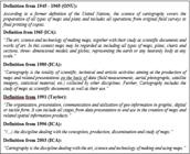
Still following this line of thought, when analyzing the longer definition that highlights cartography's “(...) unique facility for the creation and manipulation of visual or virtual representations of geospacer - maps - to permit the exploration, analysis, understanding and communication of information about that space.” (ICA, 2003, p. 17), it is possible to question whether this would not be what Taylor (1991) called cartography's capacity for “organization, presentation, communication and use of geoinformation” apart from the term geoinformation, which is crucial for spatial representations and analysis throughout history, as presented by Castiglione (2021).
Despite these asymmetries in the attempt to restructure the concept of cartography that had become unproductive in 1996, what draws attention is the fact that, even with the issues in the considerations of 2003 and all the development that the field experienced over the following two decades, there were no new efforts by the ICA to work on the theme of construction of the concept of cartography.
CONCLUSION
Conceptual definitions are a crucial element in scientific research, serving to delimit the topic of study, position the researcher, and guide methodological approaches. The ethical importance of delimiting concepts both for the academic community and for readers should also be highlighted, as social, cultural, historical and economic factors influence the construction, understanding and application of these concepts.
In this context, this article aims to revisit the definitions of cartography established by the ICA between 1960 and 2000. Over these four decades, the ICA has officially formulated three definitions, in addition to an unofficially recognized one. It was observed that these definitions were intrinsically linked to the transformations that occurred in related fields, especially the advances in the area of computing.
Although debates about the definition of cartography were constantly evolving and improving throughout the second half of the twentieth century, this maturation process was expected to extend into the 21st century. However, contrary to the trends observed since the 60s, a setback in the conceptualisation of cartography can be noticed, which has not been consistently addressed. The last definition of cartography by the ICA is dated from 2003 and still has several gaps, which were not taken on due to the suppression of debates around the theme.
This dynamic demonstrates that the evolution of scientific debates does not always follow a linear upward trajectory and can oscillate between advances and setbacks. Given this scenario, it is imperative to resume the debates on the definition of cartography. The field has long experienced technological advances and new theoretical perspectives that expand the possibilities of mapping both material and immaterial aspects of reality.
Although the contributions of Taylor (1991) are still relevant to understanding cartographic transformations from the perspective of geoinformation, it is possible that, given the accumulation of innovations and changes, it is necessary to establish new conceptual definitions soon to encompass the new reality and needs of society towards cartography, which Taylor (1991) could not have had imagined.
NOTES
REFERENCES
- ANDREWS, S. K. Creating Interactive Media on CD-ROM. Cartographic Perspectives, [s. l.], n. 19, p. 31-39, 1994.
-
BAZARIAN, J. O Problema da Verdade: Teoria do Conhecimento. 2. ed. São Paulo: Editora Alfa-Omega, 1985. E-book. Disponível em: https://pt.scribd.com/document/367988723/BAZARIAN-Jacob-O-Problema-da-Verdade-pdf Acesso em: 7 abr. 2020.
» https://pt.scribd.com/document/367988723/BAZARIAN-Jacob-O-Problema-da-Verdade-pdf -
BROMMER, S. Education in Cartography: (Report of Commission I of the International Cartographic Association). Cartography, [s. l.], v. 7, n. 1, p. 13-17, 1969. Disponível em: http://dx.doi.org/10.1080/00690805.1969.10437670 Acesso em: 31 out. 2023.
» http://dx.doi.org/10.1080/00690805.1969.10437670 -
CÂMARA, G.; DAVIS, C. Introdução a Ciencia da Geoinformação. 1. ed. São José dos Campos: Instituto Nacional de Pesquisas Espaciais (INPE), 2004. E-book. Disponível em: http://www.dpi.inpe.br/gilberto/livro/introd/index.html Acesso em: 7 abr. 2020.
» http://www.dpi.inpe.br/gilberto/livro/introd/index.html -
CAMMACK, R. G. New Map Design Challenges: Interactive Map Products for the World Wide Web. In: CARTWRIGHT, W.; PETERSON, M. P.; GARTNER, G. (org.). Multimedia Cartography. Berlin, Heidelberg: Springer Berlin Heidelberg, 1999. p. 155-172. E-book. Disponível em: https://doi.org/10.1007/978-3-662-03784-3_16 Acesso em: 21 abr. 2024.
» https://doi.org/10.1007/978-3-662-03784-3_16 -
CASTIGLIONE, L. H. G. Epistemologia da Geoinformação: Uma Análise Histórico-Crítica. 2009. 371 f. - UNIVERSIDADE FEDERAL FLUMINENSE, [s. l.], 2009. Disponível em: https://app.uff.br/riuff/handle/1/24599 Acesso em: 31 out. 2023.
» https://app.uff.br/riuff/handle/1/24599 -
CASTIGLIONE, L.H.G. Prefácio: Evolução Histórica da Geoinformação. In: MENEZES, P. M. L.; FERNANDES, M. C.; CRUZ, C. B. M. (orgs.) Cartografias do Ontem, Hoje e Amanhã. Curitiba: Appris, 2021. https://pantheon.ufrj.br/bitstream/11422/18763/1/CartografiasOntemHojeAmanha.pdf
» https://pantheon.ufrj.br/bitstream/11422/18763/1/CartografiasOntemHojeAmanha.pdf -
ESRI. História da Empresa. [S. l.], 2011. Disponível em: https://web.archive.org/web/20090703135917/http://www.esri.com/company/about/history.html Acesso em: 29 mar. 2019.
» https://web.archive.org/web/20090703135917/http://www.esri.com/company/about/history.html - FRANCO, J. R. Cartografias Criativas: Da Razão Cartográfica às Mídias Móveis. 1. ed. Curitiba: Appris, 2019.
-
GENZ, J. H. Resolving Ambivalence In Marshallese Navigation:Relearning, Reinterpreting, and Reviving the “Stick Chart” Wave Models. Structure and Dynamics: eJournal of Anthropological and Related Sciences, [s. l.], v. 9, n. 1, 2016. Disponível em: https://escholarship.org/uc/item/43h1d0d7 Acesso em: 26 dez. 2023.
» https://escholarship.org/uc/item/43h1d0d7 - GOMES, L. Escravidão - Volume 1: Do Primeiro Leilão de Cativos em Portugal Até a Morte de Zumbi dos Palmares. 1. ed. São Paulo: Globo Livros, 2019.
-
KENT, A. J. A profession less ordinary? Reflections on the Life, Death and Resurrection of Cartography. Bulletin of the Society of Cartographers, [s. l.], v. 48, n. 1-2, p. 7-16, 2015. Disponível em: https://www.researchgate.net/publication/282123268_A_Profession_Less_Ordinary_Reflections_on_the_Life_Death_and_Resurrection_of_Cartography . Acesso em: 21 abr. 2024.
» https://www.researchgate.net/publication/282123268_A_Profession_Less_Ordinary_Reflections_on_the_Life_Death_and_Resurrection_of_Cartography - KUHN, T. S. A Estrutura das Revoluções Científicas. 5. ed. São Paulo: Pespectiva S.A, 2017.
-
MENEZES, P. M. L. de; ÁVILA, A. de S. Novas Tecnologias Cartográficas em Apoio ao Ensino e Pesquisa em Geografia. In: , 2005, São Paulo. Anais do X Encontro de Geógrafos da América Latina. São Paulo: Observatorio Geográfico de América Latina, 2005. p. 9314-9327. Disponível em: http://observatoriogeograficoamericalatina.org.mx/egal10/Nuevastecnologias/Cartografiatematica/13.pdf Acesso em: 26 dez. 2023.
» http://observatoriogeograficoamericalatina.org.mx/egal10/Nuevastecnologias/Cartografiatematica/13.pdf -
ORMELING, F. J. The International Cartographic Association: An Information Paper. American Cartographer, [s. l.], v. 7, n. 1, p. 5-18, 1980. Disponível em: http:www.doi.org/10.1559/152304080784522900 Acesso em: 31 out. 2023.
» http:www.doi.org/10.1559/152304080784522900 - GOMES, P. C. C. Quadros Geográficos: Uma Forma de Ver, uma Forma de Pensar. 1. ed. Rio de Janeiro: Bertrand Brasil, 2017.
-
PETERSON, M. P. Hypermedia Maps and the Internet. In: STEFANAKIS, E. et al. (org.). Geographic Hypermedia: Concepts and Systems. Berlin, Heidelberg: Springer Berlin Heidelberg, 2006. p. 121-136. E-book. Disponível em: https://doi.org/10.1007/978-3-540-34238-0_7 Acesso em: 26 dez. 2023.
» https://doi.org/10.1007/978-3-540-34238-0_7 -
POLOUS, N. Smart Cartography: Representing Complex Geographical Reality of 21st Century. International Journal of Cartography, [s. l.], v. 9, n. 3, p. 619-637, 2023. Disponível em: https://doi.org/10.1080/23729333.2023.2235498 Acesso em: 28 jun. 2024.
» https://doi.org/10.1080/23729333.2023.2235498 - POPPER, K. R. Normal Science and its Dangers. In: Criticism and The Growth Of Knowledge. [S. l.: s. n.], 2014.
- POPPER, K. R. O Mito do Contexto: Em Defesa da Ciência e da Recionalidade. Lisboa: Edições 70, 1996.
-
RIBEIRO, D.; CAQUARD, S. Cartography and Art. Geographic Information Science & Technology Body of Knowledge, [s. l.], v. 2018, n. Q1, 2018. Disponível em: http://gistbok.ucgis.org/bok-topics/cartography-and-art Acesso em: 31 out. 2023.
» http://gistbok.ucgis.org/bok-topics/cartography-and-art -
ROCHA, C. H. B. Geomática na Prática. 1. ed. São Paulo: Editora CRV, 2019. E-book. Disponível em: https://editoracrv.com.br/produtos/detalhes/33810-crv Acesso em: 26 dez. 2023.
» https://editoracrv.com.br/produtos/detalhes/33810-crv - SILVA, A. de B. Sistemas de Informações Geo-Referenciadas. São Paulo: Editora Unicamp, 2003.
-
TAYLOR, D. R. F. A Conceptual Basis For Cartography/New Directions For the Information Era: Keynote presentation to the ICA General Assembly at Bournemouth, U.K., September 1991. Cartographica: The International Journal for Geographic Information and Geovisualization, [s. l.], v. 28, n. 4, p. 1-8, 1991. Disponível em: https://utpjournals.press/doi/10.3138/P471-L334-2007-1Q44 Acesso em: 31 out. 2023.
» https://utpjournals.press/doi/10.3138/P471-L334-2007-1Q44 -
THE INTERNATIONAL CARTOGRAPHIC ASSOCIATION (ICA). A Strategic Plan For the International Cartographic Association 2003-2011. Map, Journal of the Japan Cartographers Association, [s. l.], p. 61-73, 2003. Disponível em: https://icaci.org/files/documents/reference_docs/ICA_Strategic_Plan_2003-2011.pdf Acesso em: 29 jun. 2024.
» https://icaci.org/files/documents/reference_docs/ICA_Strategic_Plan_2003-2011.pdf -
THE INTERNATIONAL CARTOGRAPHIC ASSOCIATION (ICA). The International Cartographic Association: Tenth bi-annual meeting. The Cartographic Journal, [s. l.], v. 17, n. 1, p. 53-56, 1980. Disponível em: http://www.tandfonline.com/doi/full/10.1179/caj.1980.17.1.53 Acesso em: 31 out. 2023.
» http://www.tandfonline.com/doi/full/10.1179/caj.1980.17.1.53 -
THE INTERNATIONAL CARTOGRAPHIC ASSOCIATION (ICA). The International Cartographic Association: ICA NEWS. The Cartographic Journal, [s. l.], v. 33, n. 2, p. 187-196, 1996. Disponível em: http://dx.doi.org/10.1179/caj.1996.33.2.187 Acesso em: 31 out. 2023.
» http://dx.doi.org/10.1179/caj.1996.33.2.187 -
TOMLINSON, R. F. The Impact of the Transition From Analogue to Digital Cartographic Representation. American Cartographer, [s. l.], v. 15, n. 3, p. 249-262, 1988. Disponível em: http://dx.doi.org/10.1559/152304088783886937 Acesso em: 7 abr. 2020.
» http://dx.doi.org/10.1559/152304088783886937 -
TORNINCASA, S.; MONACO, F. D. The Future and Evolution of CAD. 14th International Research/Expert Conference “Trends in the Development of Machinery and Associated Technology” TMT 2010, [s. l.], n. September, 2010. Disponível em: https://citeseerx.ist.psu.edu/document?repid=rep1&type=pdf&doi=977f5f1b7053d84e6829c149b966f01643adcbf3 . Acesso em: 30 out. 2023.
» https://citeseerx.ist.psu.edu/document?repid=rep1&type=pdf&doi=977f5f1b7053d84e6829c149b966f01643adcbf3 -
WHITRIDGE, P. Landscapes, Houses, Bodies, Things: “Place” and the Archaeology of Inuit Imaginaries. Journal of Archaeological Method and Theory, [s. l.], v. 11, n. 2, p. 213-250, 2004. Disponível em: https://edisciplinas.usp.br/pluginfile.php/3273585/mod_resource/content/1/27.Whitridge.pdf Acesso em: 27 dez. 2023.
» https://edisciplinas.usp.br/pluginfile.php/3273585/mod_resource/content/1/27.Whitridge.pdf -
WOODWARD, D.; LEWIS, G. M. The History of Cartography, vol. 2, book 3, Cartography in the traditional African, American, Arctic, Australian and Pacific Societies. 1. ed. Chicago: The University of Chicago Press, 1998. E-book. Disponível em: https://press.uchicago.edu/books/HOC/HOC_V2_B3/Volume2_Book3.html Acesso em: 27 dez. 2023.
» https://press.uchicago.edu/books/HOC/HOC_V2_B3/Volume2_Book3.html -
ZAIDAN, R. T. Geoprocessamento: Conceitos e Definições. Revista de Geografia - PPGEO - UFJF, [s. l.], v. 7, n. 2, p. 7, 2017. Disponível em: https://periodicos.ufjf.br/index.php/geografia/article/view/18073 Acesso em: 7 abr. 2020.
» https://periodicos.ufjf.br/index.php/geografia/article/view/18073


