ABSTRACT
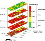
Soil compaction is one of the main constraints imposed to growth of sugar cane root system, with consequences as reduction on plant ability to absorb water and nutrients. In this context, this study had as objective to identify regions in the field with different compaction levels, allowing the adoption of site specific management. The work was carried out at the Green Valley Sugarcane Mill, in Baía Formosa, RN, Brazil. Soil penetration resistance (RSP) was used as indicative parameter of soil compaction, and was assessed in an area of 113.59 ha, divided in 12 sugarcane fields, where 113 georeferenced points were located. Determinations were made in the 0-10, 11-20, 21-30 and 31-40 cm depths, by means of a soil penetrometer with automatic data acquisition system. Data were analyzed through descriptive statistics and geostatistical tools, which were used for evaluating spatial dependence of variables and draw contour maps, after kriging interpolation. Contour maps show regions in the area with different soil compaction levels. Subsoiling may be avoided in 18.80% of the total area, mainly in the fields 45 and 48. In other regions subsoiling must be performed deeper than 40 cm.
Key words:
geostatistics; soil penetrometer; soil penetration resistance

 Thumbnail
 Thumbnail
 Thumbnail


