Abstracts
The map's usage and the concerns about geographic distribution related with diseases are not a recent issue. A classical example is the John Snow survey -maps were used to locate cholera's cases and related them with the water supplying. The spatial representation techniques are fewer used in health sectors due to troubles in managing such information. So, the aim of this survey was to establish the disease spatial distribution in Ribeirão Preto, 2002. Secondary data were used to elaborate this study. The spatial distribution of cases was realized by using the MapInfo 7.8 software. Although many cases were concentrated in the northeast region in the city, which consists the quarters of low economical income. The results contribute to show the Tb spatial distribution in Ribeirao Preto, they also reinforce the space category as a methodological alternative to manage, to monitor and to evaluate the health actions by directing interventions to decrease the iniquities.
tuberculosis; public health; geographic information systems
El uso de mapas y la preocupación con la distribución geográfica de enfermedades se remonta a un pasado bastante distante. Un ejemplo clásico fue el trabajo realizado por John Snow, que utilizó el mapeamiento para localizar casos de cólera. A pesar de su gran potencial, las técnicas de representación espacial aún son relativamente poco utilizadas en el área de la salud. El objetivo de este trabajo fue establecer la distribución espacial de la enfermedad en Ribeirão Preto, 2002. Se utilizó la base de datos secundarios Epi-tb. El georreferenciamiento de los casos fue realizado por el software MapInfo 7.8. Los casos estuvieron concentrados en una parte de la región nor-oeste del municipio. Los resultados contribuyen para el conocimiento de la distribución espacial de la Tb en de Ribeirão Preto, resaltando la importancia de la categoria espacio como alternativa metodológica para auxiliar en el planeamiento, monitoramiento y evaluación de las acciones en salud, dirigiendo las intervenciones para disminuir las inequidades.
tuberculosis; salud pública; sistemas de información geográfica
O uso de mapas e a preocupação com a distribuição geográfica de doenças remonta a um passado distante. Um exemplo clássico foi o trabalho realizado por John Snow, que utilizou mapeamento para localizar casos de cólera, relacionando-os com fontes de abastecimento de água. As técnicas de representação espacial ainda são pouco utilizadas na área da saúde, devido às dificuldades inerentes à manipulação desse tipo de informação. O objetivo do trabalho foi estabelecer a distribuição espacial da doença no município de Ribeirão Preto, 2002. Utilizou-se o banco de dados Epi-tb. Utilizou-se o software MapInfo 7.8 para geocodificação dos casos. Os casos concentraram-se na região Noroeste do município. Os resultados contribuem para o conhecimento da distribuição espacial da Tuberculose em Ribeirão Preto, ressaltando a importância da categoria espaço como alternativa metodológica para auxiliar no planejamento, monitoramento e avaliação das ações em saúde, direcionando as intervenções para diminuir as iniqüidades.
tuberculose; saúde pública; sistemas de informação geográfica
ORIGINAL ARTICLE
Geoprocessing in health area
Paula HinoI; Tereza Cristina Scatena VillaII; Cinthia Midori SassakiI; Jordana de Almeida NogueiraIII; Claudia Benedita dos SantosII
IDoctoral student, paulahino@yahoo.com.br; midsas@eerp.usp.br;
IIProfessor, e-mail: tite@eerp.usp.br, cbsantos@eerp.usp.br. University of São Paulo at Ribeirão Preto College of Nursing - WHO Collaborating Centre for Nursing Research Development
IIIRN, Coordinator of the Tuberculosis Control Program, Ribeirão Preto Bureau, Brazil
ABSTRACT
The map's usage and the concerns about geographic distribution related with diseases are not a recent issue. A classical example is the John Snow survey -maps were used to locate cholera's cases and related them with the water supplying. The spatial representation techniques are fewer used in health sectors due to troubles in managing such information. So, the aim of this survey was to establish the disease spatial distribution in Ribeirão Preto, 2002. Secondary data were used to elaborate this study. The spatial distribution of cases was realized by using the MapInfo 7.8 software. Although many cases were concentrated in the northeast region in the city, which consists the quarters of low economical income. The results contribute to show the Tb spatial distribution in Ribeirao Preto, they also reinforce the space category as a methodological alternative to manage, to monitor and to evaluate the health actions by directing interventions to decrease the iniquities.
Descriptors: tuberculosis; public health; geographic information systems
INTRODUCTION
Analyzing disease distribution and determinants in populations in space and time is an essential aspect of empidemiology. It involves primordial issues such as: Who became ill? Where did the disease occur? When did the disease occur?
There is a classic study by the British doctor, John Snow, who while analyzing a cholera epidemic that took place in London in the year 1854, sought to demonstrate an association between cholera deaths and water supply through public plumbing. Two competitors, the Lambeth Company and the Southwark and Vauxhall Company, supplied homes with water in London. Lambeth extracted water from the Thames River at a point before sewage was dumped into it, whereas Southwark and Vauxhall would collect their water after that point. This was the perfect opportunity to check if the sewage-contaminated water caused cholera. Snow obtained a list of cholera deaths and investigated which companies each home received their water from. Snow reached conclusive results: while 37 deaths occurred among the 10,000 homes supplied by the Lambeth Company, there were 315 deaths in the 10,000 residences that had their water provided by the Southwark and Vauxhall Company. Thus throughout Snow's exhaustive work of data collection and interpretation, he gradually built one of the most important points of his method. He concluded that it is essential to first become acquainted with the facts in their most intimate details, and then formulate a feasible causal explanation(1).
In Snow's work, the origin of the epidemic was discovered despite not knowing its etiologic agent(2-4). The spatial relationship of the data contributed to better understanding that phenomenon. This case is acknowledged as one of the first examples of spatial analysis.
The study of spatial variation yields a comparative diagnosis which may be used in the following ways: to indicate which risks a particular population is exposed to; to track the dissemination of health hazards; to provide subsidiaries to causal explanations; and to identify intervention priorities and assess the impact of such interventions(5).
Geoprocessing is acknowledged as a group of techniques for collecting, treating, and displaying referenced information in a specific geographic space. Among such techniques are the following: remote sensing, data digitalization, automation of cartographic tasks, Global Positioning System (GPS), and Geographic Information System (GIS).
Georeferenciating health events is important to the analysis and evaluation of collective health risks, particularly those related to the environment and to the socioeconomic profile of a population( 6).
Thematic maps are powerful instruments in the spatial analysis of a certain disease risk. Their purpose is to describe and display the event's spatial distribution. In addition, thematic maps may be used with an exploratory approach, since they reveal the locations of the event as well as unknown etiologic factors, which may be used hypothetically to point out associations between the event and its causes(7).
In Brazil, little is known about the spatial distribution of endemic disease in urban areas. In the 1960s and 1970s, there was a migration to urban regions due to population displacement. Urbanization of the population and the phenomenon of periphery growth in big cities made the task of controlling the transmission of some diseases an even more complex one which required new control strategies(8).
The methods for spatial analysis may be divided in the following categories:
- Visualization - primarily used to map health events from their point patterns to the complex overlap of disease incidence maps, which describe the distribution of specific variables of interest.
- Exploratory data analysis - used to describe spatial patterns and relations between maps. Some exploratory techniques take the form of graphs (histograms, scatter plots, and others) and others of a cartographic nature.
- Modeling - used to formally test a hypothesis or to estimate relations, for instance, between the incidence of a disease and the environmental variables.
Applying a GIS in health research provides interesting possibilities and allows researchers to apply new methods in handling spatial information. This becomes a powerful tool connecting health and environment. Nonetheless, a researcher's evaluation is indispensable, since there are no automated mechanisms to interpret the obtained results(4).
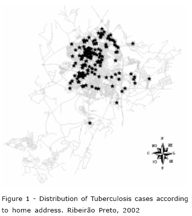
Although a GIS may be used to consolidate and analyze large databases concerning environment and health, an effort must be made so that data addressing techniques are compatible. This implies an adequacy between databases and the cartographic base(9). The quality of the address information and the efficiency of the GIS in locating event points are essential to the analysis of these events' distribution patterns. This study aims to present an example through the spatial distribution of Tuberculosis (Tb) cases according to home address in the urban area of Ribeirão Preto for the year 2002.
METHOD
Geographic area
Ribeirão Preto is located in the Northeast of São Paulo state, approximately 313 km from the State Capital. According to the Year 2000 Demographic Census, it has a population of 504,923, and is one of the largest cities in São Paulo state and in Brazil.
Type of study
This is a sectional study. "Sectional or cross-sectional studies are investigations that provide current information about the health status of a population or community, based on the individual evaluation of each group member's state of health. It produces global health indicators for the assessed group, and is therefore of great use in the community diagnosis of the local health situation"(10).
Data collection
Information concerning the year 2002 was collected from the Ribeirão Preto Municipal Health Secretary's Tuberculosis notification database (EPI-TB). The study's population is composed of Tb patients, who participated in the city's Tuberculosis Control Program (PCT-Programa de Controle de Tuberculose) in 2002.
Data analysis
To obtain the thematic map, the data were georeferenced using MapInfo 7.8 software. Initially an automated form of georeferencing was employed, but an interactive form was also used when needed. The point patterns were set in this phase. Addresses of the case reports were displayed in such a way as to obtain a connection with the digital cartographic base. This was a time-consuming procedure due to missing information in some of the addresses provided, and because the street characteristics did not allow for using the automated form. Addresses were manually researched using a phone book, street guide and an analogical map in order to make the information usable.
Ethical procedures
The study was approved by the Research Ethics Committee of the University of São Paulo Nursing School. Confidentiality was assured because the study used information exclusively from the EPI-TB databank and did not involve patient identification. The study was thus exempted from the need to use Informed Consent (Terms).
RESULTS AND DISCUSSION
Tb cases in 2002 were georeferenced according to home addresses. Over 89.9% of the cases were georeferenced. The remaining 10.1% of cases were impossible to georeference because addresses were either not provided or nonexistent. This indicates that more accurate information-gathering is necessary in order to benefit the population. Only then can proper measures be taken in reducing hazards to individuals with tuberculosis and their contacts, and consequently, preventing the dissemination of the disease within the community.
The thematic map shows how the spatial distribution of Tb cases is heterogeneous for the studied period. There is a high concentration of cases in the city's Northeast, whereas the remaining cases are distributed irregularly within other neighborhoods.
This area of high concentration includes specific locations with higher risk for disease transmission, such as slums and public jails. Insalubrity, poverty, and overpopulation prevailed in these places. The incidence of Tb decreased towards other areas with greater quality of life. An epidemiologic approach was proposed, beginning with punctually locating the events. Micro-areas were then differentiated throughout the spatial pattern formed by the locations of residences with Tb cases, i.e., by the pattern of point density. Such a method allowed for the identification of areas with a higher concentration of Tb cases without having to previously cluster them into administrative units, such as neighborhoods.
GIS is an effective method of identifying priority areas which demand Tb control actions. The aim is to interrupt transmission of the disease and to reduce its incidence. An ecological study using GIS, performed in the Brazilian Northeast, identified areas with events relevant to the Tb-transmission process (families with retreatment or with more than one case in the period) and areas with a higher incidence of the disease. This information proved to be a useful tool because by identifying priority population groups and by directing attention to priority micro-areas in need of intensive interventions, it was possible to organize a territorial surveillance system. This system allows researchers to face the Tb problem with a rational use of resources(11).
A study was performed in the city of Ribeirão Preto for the period of 1990 to 2000 with the purpose of understanding the endemic process of Tb and to provide additional information for the city's health information system. Results revealed that for each year studied there was a specific pattern of Tb spatial distribution with homogeneous areas of disease risk. The assorted distribution of Tb cases in the city suggests an association with areas traditionally more deprived(12).
Tb is a public health issue intimately connected to urban poverty, overpopulation, inadequate housing, and unemployment, in addition to the lack of organization in health systems and to the resistance to drugs used in Tb treatment. This situation has worsened due to the association of Tb/HIV(13-14).
The purpose of Epidemiologic Surveillance (ES) is to reduce transmission of the bacillus into the population. This is accomplished through actions such as early diagnosis and treatment, and the search for sputum smear positive patients within the population of symptomatic patients and contacts.
CONCLUSION
In view of the critical situation of Tb, it is indispensable that an epidemiologic evaluation of Ribeirão Preto be made. Such information should then be analyzed and implemented in devising a control and response plan, since health policies and actions should be preventive. Therefore, due to its integrative ability, GIS allows for the association between the EPI-TB databank information and space. It proves to be a powerful tool, making it possible to visualize, through maps, where residences of Tb cases are located, and thus contributes to the advancement of spatial analysis.
Applying GIS in health research provides interesting possibilities, and allows researchers to apply new methods in handling spatial information. Therefore, it is a powerful tool, connecting health and the environment. The GIS environment allows for the integration of various types of information, which may offer a broader view of the situation within the context of space. However, the researcher's evaluation is indispensable since there are no automated mechanisms to interpret the obtained results. In terms of spatial and temporal diffusion of the disease, traceable information provides elements necessary to explain problems of a particular territory. This increases the power to direct specific intersectional actions, and thus provides for better decision-making through various facets of the same problem. GIS may become a powerful technological resource for planning, supervising and evaluating health actions in Brazil. It is likely that the implementation of such techniques will increase. For instance, they would be of great use in the ES of transmissible diseases, in the comparison and following of vital statistics, and in the spatial organization of health services and human resources.
ACKNOWLEDGEMENTS
The authors thank Capes for funding, and the FAPESP thematic project for acquiring the cartographic base for this study as well as MapInfo software.
Recebido em: 8.8.2005
Aprovado em: 9.3.2006
- 1. Snow J. Sobre a maneira de transmissão do cólera. São Paulo (SP): Hucitec/Abrasco; 1999.
- 2. Medronho RA, Perez M. A distribuição das doenças no espaço e no tempo. Epidemiologia. São Paulo (SP): Atheneu; 2002. p.57-71.
- 3. Costa MCN, Teixeira MGLC. A concepção do "espaço" na investigação metodológica. Cad Saúde Pública 1999 abril-junho; 15(2):271-9.
- 4. Santos SM, Barcellos C, Carvalho MS, Flores R. Detecção de aglomerados espaciais de óbitos por causas violentas em Porto Alegre, Rio Grande do Sul, Brasil, 1996. Cad Saúde Pública 2001 setembro-outubro; 17(5):1141-51.
- 5. Pereira M.G. Métodos empregados em Epidemiologia. Epidemiologia teoria e prática. 6ºed. Rio de Janeiro (RJ): Guanabara- Koogan; 2002.
- 6. Skaba DA, Carvalho MS, Barcellos C, Martins PC, Terron SL. Geoprocessamento dos dados da saúde: o tratamento dos endereços. Cad Saúde Pública 2004 novembro-dezembro; 20(6):1753-6.
- 7. Malta DC, Almeida MCM, Dias MAS, Merhy EE. A mortalidade infantil em Belo Horizonte, Minas Gerais, Brasil, por área de abrangência dos Centros de Saúde (1994-1996). Cad Saúde Pública 2001 setembro-outubro; 17(5):1189-98.
- 8. Ximenes RAA, Martelli CMT, Souza WV, Lapa TM, Albuquerque MFM, Andrade ALSS, et el. Vigilância de doenças endêmicas em áreas urbanas: a interface entre mapas de setores censitários e indicadores de morbidade. Cad Saúde Pública 1999 janeiro-março; 15(1):53-61.
- 9. Barcellos C, Santos SM. Colocando dados no mapa: a escolha da unidade espacial de agregação e integração de bases de dados em saúde e ambiente através do geoprocessamento. IESUS 1997 janeiro-março; 1(1):21-9.
- 10. Almeida N Filho, Rouquayrol MZ. Introdução à Epidemiologia. 3º ed. Rio de Janeiro (RJ): Medsi; 2004.
- 11. Souza WV, Albuquerque MFM, Barcellos C, Ximenes RAA, Carvalho MS. Tuberculose no Brasil: construção de um sistema de vigilância de base territorial. Rev Saúde Pública 2005; 39(1):82-9.
- 12. Santos CB, Hino P, Cunha TN, Villa TC, Muniz JN. Utilização de um Sistema de Informação Geográfica para descrição dos casos de tuberculose. Bol Pneumol Sanitária 2004; 12(1):7-12.
- 13. Hino P, Santos CB, Villa TCS, Muniz JN, Monroe AA. Tuberculosis patients submitted to Supervised Treatment. Ribeirão Preto - São Paulo - Brazil. 1998 and 1999. Rev Latino-am Enfermagem 2005 janeiro-fevereiro; 13(1): 27-31.
- 14. Lienhardt C, Ogden JA. Tuberculosis control in resource-poor countries: have we reached the limits of the universal paradigm?. Trop Med Int Health 2004 July; 9(7):833-41.
Publication Dates
-
Publication in this collection
09 Feb 2007 -
Date of issue
Dec 2006
History
-
Accepted
09 Mar 2006 -
Received
08 Aug 2005