 Tree-by-Tree, Trait-by-Trait: a mobile LiDAR methodology for individual-level forest growth evaluation
ABSTRACT:
This study evaluates the use of Simultaneous Localization and Mapping (SLAM)-based Mobile LiDAR Scanning (MLS) for precise forest growth trait assessments, focusing on individual tree attributes in large-scale experiments. A novel tree segmentation methodology was developed to enable tree-by-tree analysis, facilitating the estimation of essential growth parameters, such as diameter at breast height (DBH), height, and volume. The research was conducted at the Estação Experimental de Ciências Florestais de Itatinga in Brazil, where approximately 4,000 trees from two Eucalyptus species, E. cloeziana F. Muell. and E. saligna Sm, were scanned. From this dataset, a subset of 21 trees, randomly selected across diameter classes, was analyzed in detail to evaluate the methodology. The methodology demonstrated accurate delineation of individual trees and highlighted the scalability of MLS for forest experimentation. While MLS height measurements were exceptionally accurate, slight discrepancies in DBH estimations, especially for E. saligna, emphasize the need for further refinements in processing and data collection. Despite these challenges, the findings confirm the potential of MLS technology to transform forestry research by offering reliable, scalable, and efficient methods for forest management and silvicultural experimentation. Future advances in data collection and processing can enhance its performance, making LiDAR an even more robust tool in forestry science.
Keywords:
SLAM technology; Eucalyptus phenotyping; forest biometric traits; terrestrial laser scanning; tree-level inventory
Innovation in forest research requires precise, efficient, and researcher-focused measurement techniques. Traditionally, tools like measuring tapes and clinometers have been used to quantify wood volume, but these methods are labor-intensive and error-prone. Advances in Light Detection and Ranging (LiDAR) technology provide a transformative alternative, enabling rapid, high-resolution data acquisition with greater accuracy and scalability.
Mobile LiDAR Scanning (MLS) enables efficient point cloud generation at a relatively low cost. Recent technological advancements have spurred the development of diverse MLS systems that can be mounted on vehicles, backpacks, drones, or boats. These systems have demonstrated applicability across fields such as autonomous vehicles, mining, smart cities, and traffic management (Guan et al., 2014; Wang et al., 2019). In forestry, studies have validated the accuracy of MLS platforms for inventory purposes, showcasing their potential for precise tree measurement (Liang et al., 2018; Qian et al., 2017; Stal et al., 2021).
This study focuses on developing a robust segmentation methodology for Simultaneous Localization and Mapping (SLAM)-based MLS data, tailored to an experimental dataset of approximately 4,000 trees across two Eucalyptus spp. trials. We aimed to evaluate the methodology's effectiveness in delineating individual trees and estimating structural attributes such as diameter at breast height (DBH), height, and volume. By comparing traditional measurements with LiDAR-derived data, this study sought to enhance the scalability and reliability of SLAM-based MLS technology in forestry research and decision-making.
The trials were conducted by the Instituto de Pesquisa e Estudos Florestais (IPEF) at the Estação Experimental de Ciências Florestais de Itatinga, part of the Universidade de São Paulo. Located in Itatinga, in the state of São Paulo, Brazil (23°10’ S, 48°40’ W, altitude 850 m), the station features undulating terrain with slopes ranging from 2 % to 10 %. The soils are classified as Typic Haplorthox and Typic Paleudult, according to the USDA Soil Taxonomy (Soil Survey Staff, 1999). The region's climate is classified as Cwa (humid subtropical) according to the Köppen classification, characterized by hot, humid summers and cold, dry winters (Alvares et al., 2013). The average annual temperature is 20 °C, with extremes ranging from a mean minimum of 3 °C in July to a mean maximum of 32 °C in Jan. Annual precipitation averages 1,350 mm, concentrated in the summer, with no water deficit but frequent frosts in low-lying areas (Silva et al., 2023).
In September 2017, E. cloeziana (I45B190) seedlings were transplanted in the field. In August 2020, E. saligna (I46B204) seedlings were also transplanted in the field. At the time of evaluation in 2023, E. saligna was three years old, while E. cloeziana was six years old.
The evaluation included a complete inventory of both trials. Tree DBH was measured using a measuring tape, while heights were recorded using a Haglöf EC II digital clinometer. Following the conventional inventory, LiDAR scanning was conducted in both areas to generate comparative datasets.
To validate the methodology, 21 trees per species were randomly selected across diameter classes, with the sample distribution proportional to the number of trees in each class. Trees closer to the mean diameter were more frequently selected, reflecting the overall diameter distribution of the trials. The trees selected were felled, and measurements were taken every 2 m along their stems, with total height also being recorded. These measurements provided detailed data for comparing conventional and LiDAR-derived estimates.
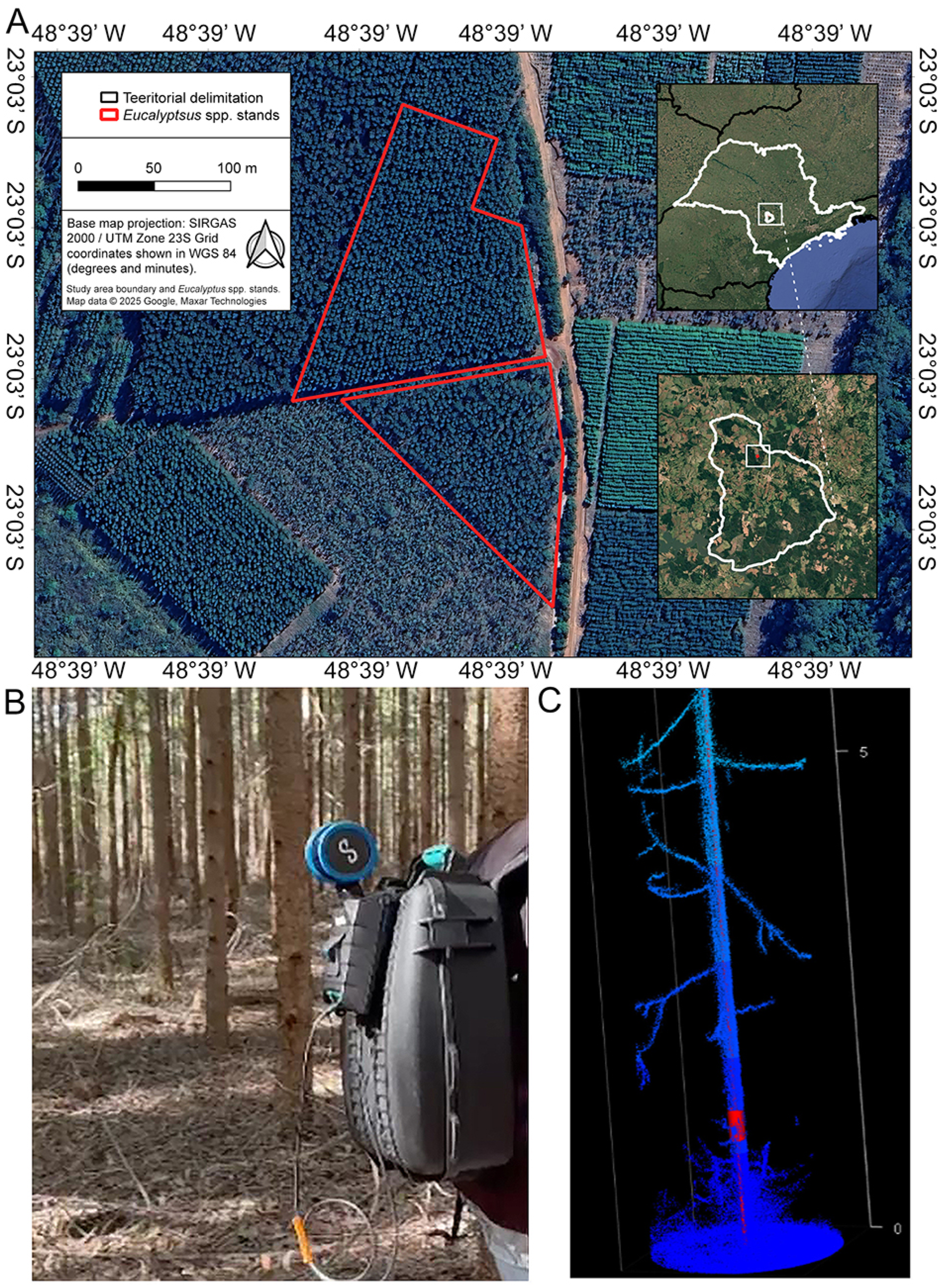
For below-canopy data collection, the Hovermap STX LiDAR system was employed, leveraging Emesent's proprietary Wildcat SLAM algorithm. This system is optimized for dense, complex environments, capturing detailed tree and understory information (Figure 1A-C). The scanning trajectory was systematically planned, covering one planting row while skipping three adjacent rows to ensure efficient coverage. The trajectory was closed by returning to the starting point, enabling the SLAM algorithm's loop closure process. This step corrected any accumulated drift, thereby enhancing the accuracy and alignment of the point cloud generated. This systematic approach ensured sufficient overlap between scanned areas, thereby optimizing data quality for subsequent analyses.
(A) Study area, comprising the progeny tests of Eucalyptus cloeziana (upper inset) and E. saligna (lower inset) at the Estação Experimental de Itatinga, municipality of Itatinga, in the state of São Paulo, Brazil. B) Researcher carrying the Hovermap STX backpack unit during an under-canopy scan. C) Point cloud of an E. cloeziana tree in the progeny test, showcasing the cylinder fit for diameter at breast height measurement in a point cloud colorized by height.
This study employed a systematic methodology to accurately delineate individual trees within a forested experimental area using an experimental grid approach. The process began with the strategic placement of control points throughout the site, which established a reference framework for subsequent analyses. These control points were used to adjust an experimental sketch to ensure precise alignment with the actual spatial layout. An experimental grid was then generated within the adjusted sketch, dividing the area into discrete grid cells. Each grid cell served as a spatial framework for organizing point cloud data and guiding tree delineation. Point cloud data within each grid cell were analyzed to localize trees, with a 1-m buffer applied to isolate individual trees for more accurate delineation.
Fine adjustments were necessary to account for the size and shape of the experimental area. Planting failures, which created distinct and recognizable patterns within the point cloud data, were used as reference points to correct the experimental sketch and ensure it accurately reflected the planting layout.
Single-tree attributes were extracted using the lidR package (version 4.0.1) in R software (version 4.3.2, R Foundation for Statistical Computing, 2024). Stem points were identified through the application of Hough transformation, which detects circular structures within the point cloud data. CloudCompare software (version 2.12, CloudCompare, 2023) was employed for point cloud denoising, enabling more precise trunk segmentation. The DBH, estimated by using a RANSAC (Random Sample Consensus) cylinder fitting at a height of 1.3 m, was measured using the TreeLS package (version 2.0.5) in R software (version 4.3.2, R Foundation for Statistical Computing, 2024). Parameter tuning for the cylinder fit was iteratively validated visually for each tree to ensure alignment with the observed geometry. Adjustments were made as needed to optimize cylinder fitting to enhance the accuracy of the DBH estimates.
Total tree height was estimated by calculating the 99th percentile of the point cloud heights, ensuring an accurate representation of the maximum height for each tree.
For single-tree volume estimation, we extracted the cross-sectional area using RANSAC from the TreeLS package. This modeling was performed using stem points at one-third of the total tree height by the Hossfeldt formula, a robust method for volume estimation documented by Graves (1907) and more recently by Ducey and Williams (2011) and McTague et al. (2020), expressed as:
where V is the volume, , the cross-sectional area at one-third of the total tree height, and H, the total height of the tree. This approach provides a reliable estimate of tree volume that enhances the precision of single-tree attribute extraction.
To validate the segmentation methodology and attribute extraction process, a subset of 21 trees was analyzed in detail. These trees, randomly selected to span the diameter range of the approximately 4,000 segmented trees, ensured robust testing across varying tree sizes.
The accuracy of DBH and height estimates was assessed by comparing the LiDAR-derived attributes with conventional measurements and detailed tree felling data. We calculated three error metrics: mean absolute error (MAE), root mean square error (RMSE), and relative root mean square error (RMSE%) as follows:
where xi represents the estimated tree structural variable, x(i,ref), the observed tree structural variable, the observed mean value, and N the number of observations.
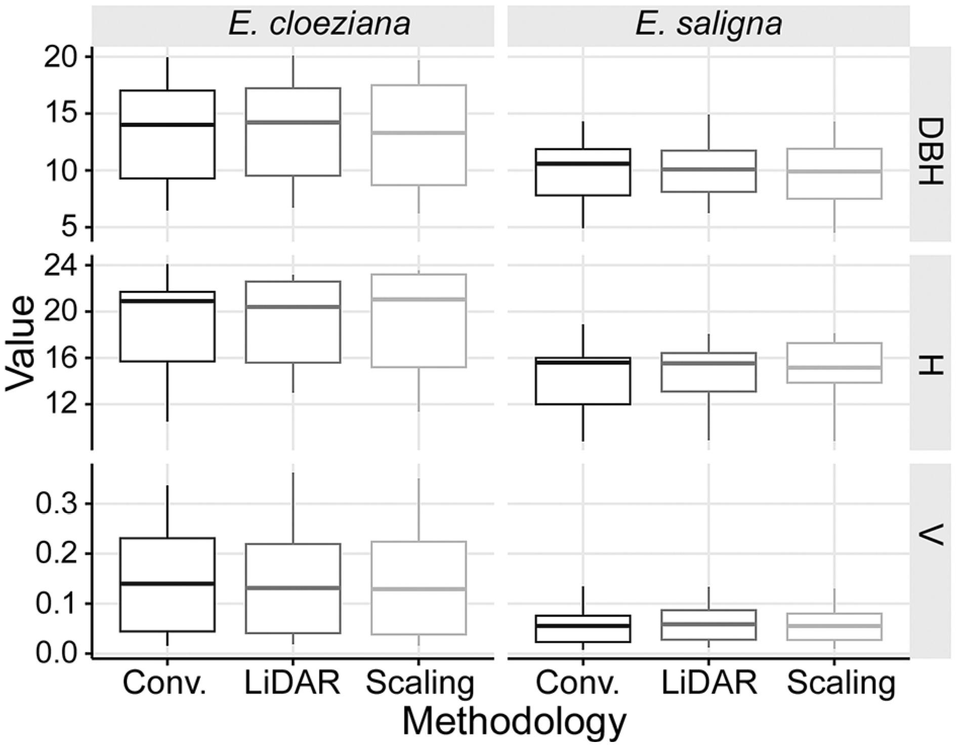
The subset analysis demonstrated the methodology's ability to accurately identify individual trees and estimate their DBH and height, validating its scalability and precision across the dataset. Conventional measurements, LiDAR scanning, and cubing showed no significant differences in the average DBH and height for either species. The boxplot visually summarizes these comparative measurements, illustrating the distribution and variability of DBH and height across methodologies for each experiment. This comparison demonstrates the consistency between the methods in estimating tree attributes (Figure 2).
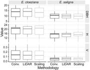
Comparison of diameter at breast height (DBH), total height (H), and volume (V) across measurement methodologies (Conventional, LiDAR, and Scaling) for Eucalyptus cloeziana and E. saligna.
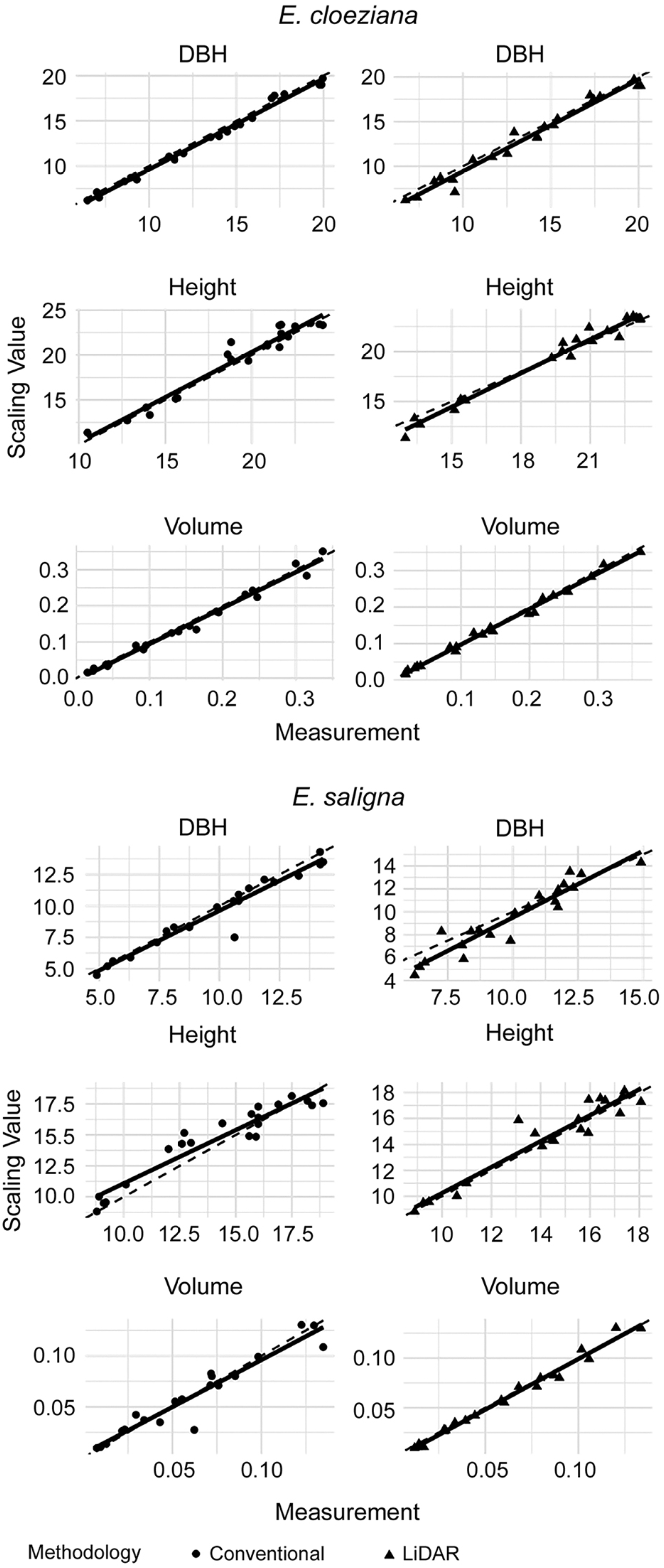
The methodology for estimating tree attributes, including DBH, height, and volume, exhibited substantial accuracy and reliability when assessed against field-measured values obtained through cubing. The results showed strong alignment between conventional measurements and LiDAR scanning, and reinforced the validity of the approach across experiments (Figure 3).
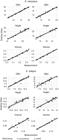
Comparison of dendrometric relationships for Eucalyptus cloeziana (top section) and E. saligna (bottom section) across different measurement methods. The analyzed variables are diameter at breast height (DBH), height, and volume, organized in rows from top to bottom, respectively. In the left column, the scatter plots show correlations between conventional measurements and the scaling method. In the right column, the correlations are between LiDAR measurements and the scaling method.
LiDAR scanning revealed slightly higher MAE for DBH measurements compared to conventional methods for both E. cloeziana and E. saligna. However, LiDAR provided superior accuracy for tree height estimation. The variability in DBH performance is likely due to species-specific traits, such as branch retention in E. saligna, which can complicate segmentation and measurement processes. These findings emphasize the need to adapt LiDAR scanning and processing techniques to account for individual species characteristics, ensuring improved measurement precision. Despite these challenges, LiDAR demonstrated strong reliability as to height measurements, and with further optimization, DBH accuracy can be enhanced to match its performance in height estimation (Table 1).
Mean absolute error (MAE), root mean square error (RMSE), and relative root mean square error (RMSE%) for the variables total height (H) and diameter at breast height (DBH) obtained from log scaling, LiDAR scanning, and conventional measurements across two Eucalyptus species: E. cloeziana and E. saligna.
The values obtained for DBH, height and volume showed robust growth for both species, comparable to those of other eucalypts known for good productivity in Brazil at similar ages (Oliveira et al., 2018; Silva et al., 2019a, b). Therefore, the populations can be considered representative and suitable for conducting the LiDAR study, which includes variations in error due to differences in species size or shape as expected due to inherent differences between species.
Our study demonstrated results consistent with those reported by Hyyppä et al. (2020), who analyzed the estimation of DBH and observed an RMSE of approximately 0.9 cm to 1.3 cm in both sparse and obstructed plots, with slightly lower RMSE values in sparse plots. This highlights the effectiveness of the LiDAR method in capturing accurate reference data across varying vegetation densities.
These findings align with previous studies, thereby demonstrating the accuracy of LiDAR in tree measurement. Diameter RMSE values ranged from 2.4 cm to 7.5 cm using an adapted Hough transformation denoising and circle fit RANSAC algorithm on boreal tree species. Scots pine achieved the highest precision (RMSE = 2.38 cm), followed by Norway spruce (RMSE = 6.18 cm) and deciduous species (RMSE = 7.48 cm) (Olofsson et al., 2014). Similarly, Terrestrial Laser Scanning (TLS) and MLS provided reliable DBH estimates, with negative biases of 1.53 cm and 2.49 cm, respectively. The strong correlation between DBH estimates from TLS and MLS (R2 = 0.99; RMSE = 1.21 cm) underscores the ability of circle-fitting methods to yield consistent results despite noisier MLS point clouds (Vandendaele et al., 2022).
The higher error rates observed in LiDAR DBH measurements for E. saligna in our study can be attributed to species-specific traits and plantation characteristics. Unlike E. cloeziana, E. saligna retains more branches along the stem due to limited self-pruning. This phenomenon, influenced by population age, planting density, and species characteristics according to Montagu et al. (2003), coupled with the smaller size of trees in the three-year-old plantation, poses challenges for point cloud segmentation and stem identification.
To address these challenges, optimizing the point cloud density is crucial. A denser point cloud can improve stem segmentation accuracy, facilitating more precise measurements in species like E. saligna. By accounting for these species-specific traits and plantation conditions during the scanning process, LiDAR technology can be further refined to enhance its reliability and accuracy for forestry research and management (Conto et al., 2017). For future experiments, increasing the number of strategically placed control points, including in areas with planting failures, is recommended to improve grid placement accuracy and efficiency further. This methodology demonstrates the potential to enhance tree delineation in forest experiments and contribute to advancements in forestry research and management.
Inspired by the study which emphasized the potential of the Hossfeldt formula for accurate volume estimation in Eucalyptus plantations, we successfully integrated this approach with LiDAR technology (McTague et al., 2020). Our results demonstrated the robustness of the Hossfeldt formula when applied to remote sensing data, providing reliable estimates of tree volume while reducing the reliance on destructive sampling. This integration highlights the potential of combining advanced mathematical models with cutting-edge remote sensing techniques for forestry applications.
Future research should focus on validating and expanding these findings by incorporating larger and more diverse datasets. Expanding the scope to include a broader range of forest types, silvicultural practices, and species will confirm the scalability and adaptability of this methodology. These efforts could further enhance its utility in forest management and experimentation, and pave the way for more efficient, precise, and sustainable forestry practices.
This study successfully demonstrated the precision and applicability of a novel segmentation methodology for LiDAR data in forestry research. By applying the methodology to two experiments encompassing approximately 4,000 trees and analyzing a representative subset of 42 trees in detail, we validated its reliability in accurately delineating individual trees within large-scale datasets. The detailed tree-by-tree analysis provided precise estimates of critical growth parameters such as DBH, height, and volume, which are essential to the assessment of forest experiments and supporting silvicultural decision-making.
While LiDAR-based height measurements exhibited substantial accuracy, minor discrepancies in DBH estimation, particularly for species such as E. saligna, underscore the need for further calibration and refinements in data processing. These discrepancies are likely attributable to species-specific traits and structural characteristics, which should be considered in future optimization efforts. Despite these challenges, the methodology significantly enhances the scalability of SLAM-based MLS technology, enabling its broader application in forest research and management.
With these advances, the proposed methodology establishes itself as a robust and scalable tool for forestry research, offering precise and efficient solutions for tree attribute estimation and forest experimentation. This work sets the stage for future innovations, integrating LiDAR technology into routine forest management and advancing the precision of silvicultural practices.
Data availability statement
The measurement data (e.g., DBH, height, and volume) supporting the findings of this study are available upon request from the corresponding author.
Acknowledgments
We thank all the companies affiliated with the Programa Cooperativo sobre Melhoramento Florestal at Instituto de Pesquisas e Estudos Florestais (IPEF), especially Arbogen, Bracell, CMPC, Klabin, Sylvamo, and Veracel, for their support with the LiDAR project. We also extend our gratitude to the Estação Experimental de Itatinga for supporting the trials of E. cloeziana and E. saligna. Additionally, we thank Conselho Nacional de Desenvolvimento Científico e Tecnológico (CNPq) for the Research Productivity Scholarship 305290/2023-1
References
-
Alvares CA, Stape JL, Sentelhas PC, Gonçalves JLM, Sparovek G. 2013. Köppen's climate classification map for Brazil. Meteorologische Zeitschrift, 22: 711-728. https://doi.org/10.1127/0941-2948/2013/0507
» https://doi.org/10.1127/0941-2948/2013/0507 -
Conto TC, Olofsson K, Görgens EB, Rodriguez LCE, Almeida G. 2017. Performance of stem denoising and stem modelling algorithms on single tree point clouds from terrestrial laser scanning. Computers and Electronics in Agriculture 143: 165-176. https://doi.org/10.1016/j.compag.2017.10.019
» https://doi.org/10.1016/j.compag.2017.10.019 -
Ducey MJ, Williams MS. 2011. Comparison of Hossfeld's method and two modern methods for volume estimation of standing trees. Western Journal of Applied Forestry 26: 19-23. https://doi.org/10.1093/wjaf/26.1.19
» https://doi.org/10.1093/wjaf/26.1.19 - Graves HS. 1907. Forest Mensuration. John Wiley, New York, NY, USA.
-
Guan H, Li J, Yu Y, Wang C, Chapman M, Yang B. 2014. Using mobile laser scanning data for automated extraction of road markings. ISPRS Journal of Photogrammetry and Remote Sensing 87: 93-107. https://doi.org/10.1016/j.isprsjprs.2013.11.005
» https://doi.org/10.1016/j.isprsjprs.2013.11.005 -
Hyyppä E, Kukko A, Kaijaluoto R, White JC, Wulder MA, Pyörälä J, et al. 2020. Accurate derivation of stem curve and volume using backpack mobile laser scanning. ISPRS Journal of Photogrammetry and Remote Sensing 161: 246-262. https://doi.org/10.1016/j.isprsjprs.2020.01.018
» https://doi.org/10.1016/j.isprsjprs.2020.01.018 -
Liang X, Kukko A, Hyyppä J, Lehtomäki M, Pyörälä J, Yu X, et al. 2018. In-situ measurements from mobile platforms: an emerging approach to address the old challenges associated with forest inventories. ISPRS Journal of Photogrammetry and Remote Sensing 143: 97-107. https://doi.org/10.1016/j.isprsjprs.2018.04.019
» https://doi.org/10.1016/j.isprsjprs.2018.04.019 -
McTague JP, Scolforo HF, Scolforo JRS. 2020. Early volume formulas, taper, implicit volume ratio, and auxiliary information: a new system of volume equations invariant to silvicultural practices, site, and genetic pedigree. Forest Ecology and Management 475: 118412. https://doi.org/10.1016/j.foreco.2020.118412
» https://doi.org/10.1016/j.foreco.2020.118412 -
Montagu KD, Kearney DE, Smith RGB. 2003. The biology and silviculture of pruning planted eucalypts for clear wood production: a review. Forest Ecology and Management 179: 1-13. https://doi.org/10.1016/S0378-1127(02)00579-0
» https://doi.org/10.1016/S0378-1127(02)00579-0 -
Oliveira TWG, Paula RC, Moraes MLT, Alvares CA, Miranda AC, Silva PHM. 2018. Stability and adaptability for wood volume in the selection of Eucalyptus saligna in three environments. Pesquisa Agropecuária Brasileira 53: 611-619. https://doi.org/10.1590/S0100-204X2018000500010
» https://doi.org/10.1590/S0100-204X2018000500010 -
Olofsson K, Holmgren J, Olsson H. 2014. Tree stem and height measurements using terrestrial laser scanning and the RANSAC algorithm. Remote Sensing 6: 4323-4344. https://doi.org/10.3390/rs6054323
» https://doi.org/10.3390/rs6054323 -
Qian C, Liu H, Tang J, Chen Y, Kaartinen H, Kukko A, et al. 2017. An integrated GNSS/INS/LiDAR-SLAM positioning method for highly accurate forest stem mapping. Remote Sensing 9: 3. https://doi.org/10.3390/rs9010003
» https://doi.org/10.3390/rs9010003 -
Silva PHM, Brune A, Alvares CA, Amaral W, Moraes MLT, Grattapaglia D, et al. 2019a. Selecting for stable and productive families of Eucalyptus urophylla across a country-wide range of climates in Brazil. Canadian Journal of Forest Research 49: 87-95. https://doi.org/10.1139/cjfr-2018-0052
» https://doi.org/10.1139/cjfr-2018-0052 -
Silva PHM, Marco M, Alvares CA, Lee D, Moraes MLT, Paula RC. 2019b. Selection of Eucalyptus grandis families across contrasting environmental conditions. Crop Breeding and Applied Biotechnology 19: 47-54. https://doi.org/10.1590/1984-70332019v19n1a07
» https://doi.org/10.1590/1984-70332019v19n1a07 - Silva PHM, Vieira IG, Mendes JCT, Araujo MJ, Moreira RM. 2023. Recursos Genéticos de Eucalipto nas Estações Experimentais de Ciências Florestais da ESALQ: Usos e Manutenção. IPEF, Piracicaba, SP, Brazil (in Portuguese, with abstract in English).
- Soil Survey Staff. 1999. Soil Taxonomy: A basic system of soil classification for making and interpreting soil surveys. 2ed. USDA-NRCS, Washington, DC, USA.
-
Stal C, Verbeurgt J, De Sloover L, Wulf A. 2021. Assessment of handheld mobile terrestrial laser scanning for estimating tree parameters. Journal of Forestry Research 32: 1503-1513. https://doi.org/10.1007/s11676-020-01214-7
» https://doi.org/10.1007/s11676-020-01214-7 -
Vandendaele B, Martin-Ducup O, Fournier RA, Pelletier G, Lejeune P. 2022. Mobile laser scanning for estimating tree structural attributes in a temperate hardwood forest. Remote Sensing 14: 4522. https://doi.org/10.3390/rs14184522
» https://doi.org/10.3390/rs14184522 -
Wang Y, Chen Q, Zhu Q, Liu L, Li C, Zheng D. 2019. A survey of mobile laser scanning applications and key techniques over urban areas. Remote Sensing 11: 1540. https://doi.org/10.3390/rs11131540
» https://doi.org/10.3390/rs11131540
Edited by
-
Edited by:
Evandro Vagner Tambarussi https://orcid.org/0000-0001-9478-5379