
 Analyzing the relationship between the occurrence of landslides and terrain attributes in the extreme rainfall event in southern Brazil, May 2024
Abstract
At the end of April and beginning of May 2024, extreme rainfall occurred in the state of Rio Grande do Sul, leading to mass movements and causing loss of materials and lives. Carrying out an inventory of landslides and analyzing relief attributes is an important step towards understanding the dynamics of the occurrence of these events, enabling their prediction in future events. Through visual analysis of high spatial resolution RapidEye images, 59 landslides were identified in the Cerro Comprido basin. The landslide scars were mainly concentrated at altitudes ranging from 290 to 440m, with emphasis on the slope limit of 70% to 75%, which presented 8 scars and a high value in the frequency ratio. Regarding the characteristics of the slope, the most susceptible to landslides were those oriented in the north and east quadrants and with a convex-divergent profile. These landslides are related to the occurrence of extreme precipitation events where the accumulated precipitation values in four days were more than double the monthly average for the region, which is the main factor in triggering the landslides, occurring even in less susceptible areas.
Keywords:
Mass movements; Morphometry; Rio Grande do Sul; Hillslope
Resumo
No final do mês de abril e início do mês de maio de 2024 ocorreram precipitações extremas no estado do Rio Grande do Sul, levando a ocorrência de movimentos de massa e causando perdas materiais e de vidas. A realização do inventário dos deslizamentos e a análise dos atributos de relevo é uma importante etapa para a compreensão da dinâmica da ocorrência destes eventos, possibilitando a sua previsão em eventos futuros. Através da análise visual de imagens RapidEye de alta resolução espacial foram identificados 59 deslizamentos na bacia hidrográfica do Cerro Comprido. As cicatrizes de deslizamento se concentraram principalmente em altitudes que variam de 290 a 440m, com destaque para o limite de declividade de 70% a 75% que apresentou 8 cicatrizes e um alto valor na razão de frequência. Quanto às características da encosta, as mais suscetíveis aos deslizamentos foram as com orientação no quadrante norte e leste e perfil convexo-divergente. Estes deslizamentos estão relacionados à ocorrência de eventos extremos de precipitação onde os valores acumulados de precipitação em quatro dias foram de mais que o dobro da média mensal para a região, sendo este o principal fator para desencadear os deslizamentos, ocorrendo inclusive em áreas pouco suscetíveis.
Palavras-chave:
Movimentos de massa; Morfometria; Rio Grande do Sul; Encosta
INTRODUCTION
Rainfall events characterized by a large volume of rainfall in a short time are considered extreme due to the intensity of the phenomenon (Petrucci; Azevedo, 2023). This intensity can lead to environmental and social impacts, including hydrological and geological processes.
At the end of April and beginning of May 2024, extreme rainfall occurred in the state of Rio Grande do Sul (southern Brazil), especially in the central region. These events resulted in numerous floods and mass movements, causing loss of lives and damage to infrastructures. According to the INMET (2024), in April the state of Rio Grande do Sul recorded extreme events with accumulated rainfall of 408.3 mm for April in the municipality of Santa Maria, in the central region, which has historical averages of 257.2 mm for the month.
Mass movements are classified by many authors into different types, based on the material moved, speed and planform of the movement (Varnes, 1958; 1978; Hutchinson, 1988; Selby, 1993; Cruden; Varnes, 1996; Hungr et al., 2001; Press et al., 2006). Among the Brazilian classifications related to mass movements, Guidicini and Nieble (1984), IPT (1991) and Augusto Filho (1992) are the most noteworthy. This paper uses the Brazilian Classification and Codification of Disasters (COBRADE, 2012), which classifies landslides as a type of mass movement. Landslides are rapid movements of soil or rock with a well-defined rupture surface and short duration, where masses of land move down and off the slope (Castro, 1998). The occurrence of this process is triggered mainly by intense/accumulated rainfall, conditioned by topographical characteristics and the material composing the hillslope and influenced by human action. Therefore, preventing damage caused by this phenomenon is a difficult task.
Inventorying landslides based on the mapping of scars is important for characterizing susceptible areas (Murillo-garcía; Alcántara-ayala, 2015). Recognizing and understanding landslides is an urgent need, given that without identifying areas prone to mass movements, it is not possible to establish effective preventive and corrective measures to mitigate the damage caused by potential disasters.
Translational or planar landslides are typical of shallow, anisotropic soils/alterites and have complex relationships (Amaral et al., 1992; Corominas et al., 1996; Vieira et al., 1997; Fernandes et al., 2001; Vanacôr; Rolim, 2012; Brito et al., 2016). In this context, the research is focused on inventories of events that allows to relate the current distribution pattern to future patterns of relief instability. Thus, the processes of planar landslides are evaluated to better understand the conditioning factors of the relief in the study area.
The study area comprises the slopes that make up the group of large hills and buttes called Cerro Comprido, which is located in the central region of the state of Rio Grande do Sul, southern Brazil, between the municipalities of Dona Francisca and Faxinal do Soturno, in the Jacuí River watershed (Figure 1).

In geomorphological terms, it is located on the ridge of the Plateau, marking the transition between the sedimentary rock hills of the Rio Jacuí Depression and the high-altitude hills of the Araucaria Plateau (IBGE/RADAM, 1986). The area is part of the Paraná Sedimentary Basin, with sedimentary units of continental origin, covering the Upper Permian-Lower Cretaceous interval, and volcanic units from the Lower Cretaceous (Zerfass et al., 2007). A study by Schirmer and Robaina (2023) classified the area as a Geoenvironmental System of Steep Relief of the Plateau Ridge, which is made up of an association of large hills and valleys, formed by sedimentary rocks between the middle slopes and the base, and volcanic rocks at the top, with major restrictions on use due to their susceptibility to mass movements.
METHODOLOGY
The survey of landslides in the study area was based on the Soobitsky (2024) database, which used RapidEye images with a spatial resolution of 5m and 3m images generated by the Super Dove sensor (PSB.SD), provided in the PlanetExplorer repository (Planet Team, 2024). A visual inspection was carried out on the same images from May 5 to 15, 2024, one to two weeks after the event, in an attempt to identify the occurrence of landslides based on changes in texture and color. Based on this, vectorization was carried out, marking the rupture point of the occurrence of the events, refining and complementing the database for the subsequent analysis of the relief parameters.
The Digital Terrain Model (DTM) ALOS/PALSAR, provided by the Alaska Satellite Facility (ASF) with a spatial resolution of 12.5m, was used to analyze the relief parameters. Based on the DTM, the drainage network and the watershed boundary were extracted automatically using the watershed tool in ArcGIS Pro 3.3 software.
The same software was used to create the elevation map, divided into six classes according to the frequency of landslides in the study area. The slope tool was used to generate the slope map with the inclination defined as a percentage. In addition, to understand the dynamics of the flow of water down the slope and the characteristics of the hillslope, the planform and profile were analyzed using the curvature tool and the orientation of the hillslope using the aspect tool.
Rainfall data was acquired from the database of the CEMADEN - (2024) at the Faxinal Soturno rain gauge station with code 430800301A. Rainfall data from April 29 to May 2, 2024 was analyzed and organized into hourly precipitation. To analyze the prevailing wind direction, data was obtained from the automatic weather station in Santa Maria maintained by the INMET, which is the closest to the study area.
The development of geoprocessing and GIS methods makes it possible to represent the surface of the earth through digital models (DEM), from which topographic analysis of the area of interest can be performed, using automated calculation of a series of related variables (Pike, 2000; Muñoz, 2009; Schmidt; Hewitt, 2004; Iwahashi; Pike, 2007; Jasiewicz; Stepinski, 2013; Silveira et al., 2014; Trentin et al., 2015; 2016, Sena-Souza et al., 2015; Gomes et al., 2016; Robaina et al., 2016; Silveira, et al., 2018; Chea; Sharma, 2019; Atkinson et al., 2020).
The data from the different sources was then mapped and analyzed in a GIS environment. To support the analysis, operations were carried out using the frequency ratio method, which consists of a bivariate statistical analysis of each class of factors that influence the phenomenon concerning their areas of occurrence. Frequency ratio values greater than 1 indicate a high correlation, while values less than 1 indicate a low correlation (Esper Anglieri, 2013). This statistic was applied by comparing the landslides with the variables of hypsometry, slope, plan/profile, and slope orientation.
RESULTS
The heavy rainfall between April 29 and May 2, 2024, in Rio Grande do Sul contributed to the recording of 59 landslides in the study area. During this period, the rainfall data show a cumulative precipitation of 560 mm (Figure 2). In the early hours of April 30, rainfall reached a peak intensity of 40 mm/hour. Landslides were recorded mainly on the morning of May 1st. On that day, the accumulated rainfall reached 380 mm. Short-term accumulated precipitation can lead to the transgression of geomorphological thresholds, favoring the occurrence of landslides. The mechanisms responsible for this include an increase in positive pore pressure and a consequent decrease in the safety factor related to soil saturation (Guidicini; Nieble, 1984; Harp et al., 1990; Fernandes et al., 2001).

Hourly and accumulated rainfall during the period from April 29 to May 2, 2024. The highest occurrence period of landslides was highlighted
The occurrence of landslide processes was analyzed based on relief parameters (Gryta; Bartholomew, 1989; Vieira et al., 1997; Dietrich et al., 2020), at the point where the collapse of the slope begins. Based on digital elevation models, the role played by some topographic variables such as elevation, slope, aspect and slope shape were analyzed.
Altimetry and the occurrence of landslides
According to Vanacôr and Rolim (2012), altimetry can be an important factor in triggering landslides when it controls the thickness or type of soil and the contact between lithologies.
The study area has an altimetric variation of 486 meters, with altitudes ranging from 59 to 545 meters. Figure 3 shows the distribution of the altitude ranges and the rupture points that caused the landslides. The landslides occurred at altitudes of 134m and extend up to 509m. Thus, it is possible to verify that, within this altimetric variation, the elevation variation between 290 and 440 meters is particularly significant, as it has frequency ratio values greater than 2.

Slope and the occurrence of landslides.
Slope plays an important role in triggering landslides (Riffel, 2021). In the study area, landslide scars have occurred on gradients ranging from 21% to 115% (Figure 4). Analyzing the frequency ratio, it is noted that the values greater than 1 in the 35% to 40% class indicate a favorable condition for the occurrence of landslides. However, the conditions are most favorable in the 70% to 75% class, with 8 recorded events and a high-frequency ratio. More specifically, 42 scars are located on slopes ranging from 35% to 90%. This information indicates that these limits can be considered important for the occurrence of landslides in the study area.

Shape of the slope sections and landslide scars
The shape of the slope at the point of rupture influences the development of mass movements, as it influences the flux of water and solid materials along the slope, the accumulation of moisture and, consequently, the levels of pore pressure (Sidle et al., 1985; Fernandes et al., 2001; Fernandes; Amaral, 2003; Araújo et al., 2023). Benda (1990) notes that, in general, divergent and convex slopes are more stable, followed by slopes with flat segments and convergent and concave slopes, which are less stable. However, Ayalew et al. (2004) indicate that this relationship is not always valid.
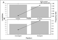
In the study area, rupture points predominate in the Convex-divergent form, with 22 scars recorded (Figure 5). The second most common pattern was concave-convergent with 16 landslides, while concave-divergent recorded 11 and convex-convergent identified 10 landslides. Thus, most of the rupture points are located on divergent slopes (33), where they are expected to be more stable and less susceptible to landslides, since slopes with this planform tend to disperse water, indicating that other characteristics of the slopes in the study area are more representative of their susceptibility to landslides. The frequency ratio indicated the Concave-Divergent characteristics as the most important due to a value greater than 1.
Relationship between altitude and slope in the occurrence of landslide scars
When comparing the frequency of landslides in relation to altitude and slope, it is possible to see a concentration of these events in two well-defined clusters and a more dispersed one (Figure 6). The well-defined clusters of landslide scars are found at relatively low altitudes, between 150m and 250m and slopes between 25% and 50%, and at medium elevation, between 270m and 380m, and slopes between 57% and 77%. Another cluster of lesser expression is formed at higher elevations, where the slopes are more varied, occurring from 52% to 117%, with a predominance at 72%.

Relationship between altitude and the curvature of the slope in the rupture area of the occurrence of landslides
Sections of the slope with predominantly convex-divergent patterns occur at all elevations where the processes analyzed occur (134 to 509m), but there is a predominance around the mid-elevations, with an average of 290.18m. The concave-convergent sections are also more significant at medium altitudes but with an average altitude of 308.94m. Concave-divergent patterns are predominant at low altitudes, with an average of 243.91m. The convex-convergent forms predominate at the transition from medium to high altitudes, with an average close to 333.40m, higher than the other forms (Figure 7).

Distribution of landslides at different elevations, considering the planform and profile of the slope
Relationship between slope gradient and the curvature of the slope in the area of occurrence of landslides
In the sections of the slope where the ruptures occur, the convex-divergent patterns are linked to the slopes in all the ranges of occurrence of the scars analyzed (21 to 115%) (Figure 8). The average value is 57.85% and there is a concentration around 40% slope gradient. The concave-convergent shapes occur in a relatively more dispersed distribution and range from 21% to 107% of slope gradient. There is a concentration in the 62% to 75% slope range. The average slope obtained in the distribution of this curvature is 60.16%. The concave-divergent form shows the least dispersion, ranging from 25% to 75% of slope. The average is 49.34% and there is a concentration of inclinations around 49%. The convex-convergent forms occur on slopes ranging from 24% to 105%. The average slope is 65.74%. This form does not have a marked concentration in the slope classes, but three of the ten scars identified are associated with slopes around 85%.

Distribution of landslides on the different slope gradients, considering the planform and profile of the slope
Slope orientation and landslide scars
The orientation of the slopes provides information on their exposure to climatic variables such as wind, rainfall and sunlight. The event analyzed in this study shows that the slopes oriented to the north, east and northeast quadrant were the ones that recorded the highest number of scars (Figure 9). These orientations have a frequency ratio of more than 1, and the northeast direction is the most significant.

The wind can strongly influence precipitation rates, depending on the elevation and aspect of the slopes, since the direction of the wind makes slopes with the same aspect receive a greater amount of precipitation on a local scale (Rulli Meneguzzo; Rosso, 2007). Rogers et al. (2016) explain that slopes that receive more precipitation due to wind direction are more susceptible to surface erosion and mass movements.
When analyzing the wind direction in the period from April 29 to May 2, it can be seen that the east direction is predominant (Figure 10). Winds from the northeast and southeast were secondary. The predominance of winds coming from the eastern quadrant may have interfered in the occurrence of landslides, as the northeast, east and southeast-facing slopes are among the most affected.
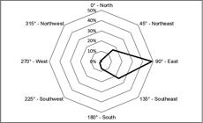
Predominant wind direction between April 29 and May 2 at the automatic meteorological station in Santa Maria, RS
DISCUSSION
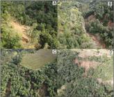
Landslide scars in the Cerro Comprido watershed occurred with different intensities (Figure 11). Photos A and B show landslides in slope areas with the displacement of the top layers of soil over the rock, while Figures 11C and 11D show more intense events with major soil loss.
The most frequent landslides in the Cerro Comprido watershed occurred at elevations of 290 to 440m, located at the headwaters of the watershed, as found by Silva (2019). This information was also found in the research by Vanacôr and Rolim (2012), who observed that in the northeastern region of Rio Grande do Sul, between the municipalities of São Vendelino and Alto Feliz, the majority of landslides occurred at elevations ranging from 200 to 450 meters.
At low altitudes, the scars are concentrated in the SE portion of the area, associated with the slope of Cerro Formoso hill. These altimetric positions indicate zones of discontinuity. However, the scars in areas at relatively lower altitudes may be associated with the contact of sedimentary facies with significant textural and structural variation. In higher elevation areas, the contact between volcanic and sedimentary rocks covered by colluvial deposits may be the main discontinuity.
The analysis of the 42 scars recorded on slopes between 35% and 90% with high values in the frequency ratio suggests a direct relationship between the increase in slope and the greater probability of landslides. The results are compatible with those obtained by Silva (2019) and Schirmer and Robaina (2023). The slope is widely recognized as one of the main factors conditioning mass movements. Dias and Herrmann (2002) indicate that slope gradient is directly proportional to the speed of movement and the transport capacity of soil and rock, because as the slope increases, the shear stress in the soil also tends to increase, which favors sliding. Therefore, the slope has a direct impact on the safety factor of the hillslope, as noted by Zaidan and Fernandes (2009), who emphasized that increasing the angle of the slope reduces this factor and, consequently, increases the probability of landslides. Avelar et al. (2013) reinforce this idea by stating that steeper slopes favor larger landslides, especially when associated with other factors, such as the type of bedrock material. In this sense, the research by Souza and Francisco (2021) also corroborates this relationship, showing that, in the mountainous region of Rio de Janeiro, the interaction between slope and curvature of the terrain increased the magnitude of landslides.
Two clusters can be seen in the relationship between the slope and the elevation of the rupture points. This reinforces the hypothesis that exist two different discontinuities. In conditions of relatively low elevation and slope, the discontinuities may be associated with abrupt textural or structural variations in sedimentary rock and/or in the contact between rock and soil. Under the defined conditions, for the area of higher altitudes and slopes, averaging around 70%, the discontinuities are markedly associated with the structures of volcanic rocks overlaid on sedimentary rocks.
In the study area, it was observed that slope limits were important in the ruptures, showing that landslides are conditioned by complex relationships. Geological factors, including lithostructural features, contacts between different rock materials and even colluvium deposits, influence ruptures (Hencher, 1987; Amaral et al., 1992; Fernandes et al., 2001). Furthermore, the aspect of the slopes indirectly affects shear strength, as it is closely related to the presence of moisture and vegetation cover (Dai; Lee, 2001). Therefore, considering that the volume of rain may be greater on slopes exposed to the direct action of the wind, caused by topoclimatic effects in which the wind promotes a directional effect of the rain and consequently greater precipitation on slopes with the same orientation as the wind direction. In conditions of extreme precipitation, the wind can potentiate this effect and increase the incidence of heavy rainfall on the slopes. In the study area, the preferential wind direction during the weather event was easterly and east-facing slopes were more affected, confirming the influence of the wind.
In general, the curvature of the slope at the rupture point can be associated with areas of contact between colluvial material and soil/rock, subjected to high levels of precipitation over a short time. The relationship between elevation and the curvature of the slope in the rupture area shows that the predominant shapes, convex-divergent, occur at all elevations. However, these are the patterns that mark the ruptures associated with the top of the hillslopes. The ruptures in the areas with convergent shapes are found at average elevations above 325m, representing middle to upper slope sections where there are contacts between lithologies.
In addition, concave-divergent patterns predominate at low elevations and represent fractures in the base of the slope. The concave portions are generally filled with colluvial deposits, as they represent zones where both surface and subsurface flows converge (Fernandes et al., 2001). The relationship between the curvature of the rupture section and the slope gradient shows that ruptures at relatively lower slopes, around 47%, are more common in divergent sections. On the other hand, in converging sections, the rupture is around 65% of the slope gradient. Therefore, ruptures in convergent sections are predominant in the middle to upper portions of the slope, with relatively higher gradients. The ruptures in the diverging sections predominate in the areas of the slope with medium altitude and relatively lower slopes.
Finally, it is important to note that these landslides are related to extreme rainfall events in the state of Rio Grande do Sul. Extreme precipitation events can trigger landslides on hillslopes where normal precipitation would not, causing landslides due to soil saturation with subsequent breakdown of cohesion, which may explain the magnitude of the landslides (Riffel, 2021). According to the data presented by rainfall measurements in the central part of the state, the accumulated values in four days (560mm) were more than twice the monthly average for the region (257.2mm) (INMET, 2024). In addition to this, the total rainfall for just May 1st was 380 mm, along with intensity peaks of 40 mm/hour during the 4-day period. As observed by several studies such as Aristizábal et al. (2022), Batumalai et al. (2023); Nazrien et al. (2022), the large volume and intensity of rainfall contributes significantly to the triggering of landslides by saturating the soil and greatly reducing the safety factor for triggering the processes.
FINAL CONSIDERATIONS
The results showed that the landslides in the Cerro Comprido watershed occurred when the accumulated rainfall reached around 380 mm in approximately 48 hours. The accumulated rainfall in the area was so significant that several relief attributes had minor contributions, as the soils became so saturated that any additional attribute, such as slope gradient, discontinuity, curvature, allowed the landslide process to be triggered.
These landslides occurred in areas with different terrain characteristics, including average elevations of 293 meters and slopes ranging from 25% to 77%. The predominant type of slope curvature was convex-divergent, and the main aspect of the landslides was the east.
It should also be noted that the landslide inventory was carried out using high spatial resolution images, which have a different scale to the Digital Terrain Model available for analyzing the relief and its attributes. Scale errors may be related to certain parameters, especially the slope planform and profile. Future studies with high-resolution DEMs are needed in the area to improve the accuracy of the attributes studied.
The methodology used in this study was fundamental, allowing landslides to be identified and correlated with a variety of terrain attributes. This study provides a resource for the study and mapping of landslide-prone areas, highlighting its importance as a support for future landslide research and analysis.
References
- AMARAL, C. P.; BARROS, W. T.; PORTO JR., R. The structural control within a landslide in Rio de Janeiro. In Bell (ed.) Landslides. Balkema, Roterdam: 1992
-
ARAÚJO, J. P. C.; BARELLA, C. F.; ZÊZERE, FERNANDES, N. F. Implementação de uma topografia pré-ruptura na predição estatística bivariada de escorregamentos. Revista Brasileira de Geomorfologia, v. 24, n. 3, 2023. https://doi.org/10.20502/rbgeomorfologia.v24i3.2305
» https://doi.org/10.20502/rbgeomorfologia.v24i3.2305 -
ARISTIZÁBAL, E.; GARCIA, E. F.; MARIN, R. J.; GÓMEZ, F.; GUZMÁN-MARTÍNEZ, J. Rainfall-intensity effect on landslide hazard assessment due to climate change in north-western Colombian Andes. Revista Facultad de Ingeniería Universidad de Antioquia, n.103, pp.51-66. Epub Feb 17, 2022. https://doi.org/10.17533/udea.redin.20201215.
» https://doi.org/10.17533/udea.redin.20201215 -
ATKINSON, J.; CLERCQ, W.; ROZANOV, A. Multi-resolution soil-landscape characterisation in KwaZulu Natal: Using geomorphons to classify local soilscapes for improved digital geomorphological modelling. Geoderma Regional, v. 22, p. 1-17, 2020.https://doi.org/10.1016/j.geodrs.2020.e00291
» https://doi.org/10.1016/j.geodrs.2020.e00291 - AUGUSTO FILHO, O. Cartas de risco de escorregamentos: uma proposta metodológica e sua aplicação no município de Ilha Bela, SP. 1992. Dissertação (Mestrado em Engenharia). Escola Politécnica, Universidade de São Paulo - SP, 1992. p.162.
-
AVELAR, A. S.; NETTO, A. L. C.; LACERDA, W. A.; BECKER, L. B.; MENDONÇA, M. B. Mechanisms of the recent catastrophic landslides in the mountainous range of Rio de Janeiro, Brazil. Landslide Science and Practice, v. 4, p. 265-270, 2013. https://doi.org/10.1007/978-3-642-31337-0_34
» https://doi.org/10.1007/978-3-642-31337-0_34 -
AYALEW, L. YAMAGISHI, H.; UGAWA, N. Landslide susceptibility mapping using GIS-basead weighted linear combination, the case in tsugawa area of Agano River, Niigata Prefecture, Japan. Landslides, v. 1, n. 1, p.73-81, 2004. https://doi.org/10.1007/s10346-003-0006-9
» https://doi.org/10.1007/s10346-003-0006-9 -
BATUMALAI, P.; MOHD NAZER, N. S.; SIMON, N.; SULAIMAN, N.; UMOR, M. R.; GHAZALI, M. A. Soil Detachment Rate of a Rainfall-Induced Landslide Soil. Water, v. 15, 2023. https://doi.org/10.3390/w15122149
» https://doi.org/10.3390/w15122149 -
BENDA, L. The influence of debris flows on channels and valley floors in the Oregon Coast Range, U. S. A. Earth Surface Processes and Lanforms, v. 15, n. 5, p. 457-466, 1990. https://doi.org/10.1002/esp.3290150508
» https://doi.org/10.1002/esp.3290150508 -
BRITO, M. M.; WEBER, E. J.; KRIGGER, V. S.; LEITZKE, F. P. Análise dos fatores condicionantes de movimentos de massa no município de Porto Alegre a partir de registros históricos. Revista Brasileira de Cartografia, [S. l.], v. 68, n. 9, 2016. https://doi.org/10.14393/rbcv68n9-44450
» https://doi.org/10.14393/rbcv68n9-44450 - CASTRO, A. L. C. Glossário de defesa civil: estudo de riscos e medicina de desastres. Brasília: MPO/ Departamento de Defesa Civil, 1998. 283 p.
-
CEMADEN - Centro Nacional de Monitoramento e Alertas de Desastres Naturais. 2024. Disponível em: https://mapainterativo.cemaden.gov.br/# Acesso em: 20 maio 2024.
» https://mapainterativo.cemaden.gov.br/# -
CHEA, H.; SHARMA, M. Residential segregation in hillside areas of Seoul, South Korea: A novel approach of geomorphons classification. Applied Geography, 108, 9-21, 2019. https://doi.org/10.1016/j.apgeog.2019.04.009
» https://doi.org/10.1016/j.apgeog.2019.04.009 -
COBRADE - Classificação e Codificação Brasileira de Desastres, 2012. Disponível em: https://www.defesacivil.rs.gov.br/upload/arquivos/202105/04095316-cobrade-classificacao-e-codificacao-brasileira-de-desastres.pdf Acesso em: 24 jul. 2024.
» https://www.defesacivil.rs.gov.br/upload/arquivos/202105/04095316-cobrade-classificacao-e-codificacao-brasileira-de-desastres.pdf - COROMINAS, J.; REMONDO, J.; FARIAS, P.; ESTEVÃO, M.; ZÊRERE, J.; DIAZ DE TERÁN, J.; DIKAU, R.; SCHROTT, L.; MOYA, J.; GONZÁLEZ, A. Debris flow. In: DIKAU, R.; BRUNSDEN, D.; SCHROTT, L. (Eds.). Landslide recognition: identification, movement and causes: identification, movement and courses. New York: john Wiley, 1996. p. 29-42.
- CRUDEN, D. M.; VARNES, D. J. Landslide types and processes. In: TURNER, K.A., SCHUSTER, R.L. Landslides - Investigation and mitigation transportation. Washington: Transportation Research Board, p. 36-75, 1996.
-
DAI, F.C.; LEE, C.F. Terrain-based mapping of landslide susceptibility using a geographical information system: A case study. Canadian Geotechnical Journal, v. 38, p. 911-923, 2001. https://doi.org/10.1139/cgj-38-5-911
» https://doi.org/10.1139/cgj-38-5-911 -
DIAS, F. P.; HERRMANN, M. L. P. Susceptibilidade a deslizamentos: estudo de caso no bairro Saco Grande, Florianópolis - SC. Caminhos de Geografia, v. 3, n. 6, p. 57-73, 2002. https://doi.org/10.14393/RCG3615295
» https://doi.org/10.14393/RCG3615295 - DIETRICH, W. E.; WILSON, C. J.; RENEAU, S. L. Cavidades, colúvios e deslizamentos de terra em paisagens de solo-manto. Processos de encostas. Routledge, p. 362-388, 2020.
- ESPER ANGLIERI, M. Y. Debris flow susceptibility mapping in a portion of the Andes and Preandes of San Juan, Argentina using frequency ratio and logistic regression models. Earth Sciences Research Journal, Bogotá, v. 17, n. 2, p. 159-167, dez. 2013.
- FERNANDES, N. F.; AMARAL, C. P. Movimentos de massa: uma abordagem geológico-geomorfológica. In: GUERRA, A. J. T. E.; CUNHA, S. B. (org.) Geomorfologia e Meio Ambiente. 4ª. ed. Rio de Janeiro: Bertrand, 2003. cap. 3, p. 123-194.
-
FERNANDES, N. F.; GUIMARÃES, R. F.; GOMES, R. A. T.; VIEIRA, B. C.; MONTGOMERY, D. R.; GREENBERG, H. Condicionantes Geomorfológicos dos Deslizamentos nas Encostas: Avaliação de Metodologias e Aplicação de Modelo de Previsão de Áreas Susceptíveis. Revista Brasileira de Geomorfologia, v. 2, n. 1, 2001. https://doi.org/10.20502/rbg.v2i1.8
» https://doi.org/10.20502/rbg.v2i1.8 - GOMES, S. M. A.; SILVEIRA, C. T.; SILVEIRA, R. M. P. Compartimentação Geomorfométrica de Unidades de Relevo das Cartas MI 2726-4 e MI 2820-2 - Estado do Paraná. 2016, Maringa/PR: UGB, p. 5, 2016.
-
GRYTA, J. J.; BARTOLOMEW, M. J. Fatores que influenciam a distribuição de avalanches de detritos associadas ao furacão Camille de 1969 no Condado de Nelson, Virgínia. Geological Society of America, v. 236, p. 15-28, 1989. https://doi.org/10.1130/SPE236-p15
» https://doi.org/10.1130/SPE236-p15 - GUIDICINI, G.; NIEBLE, C. M. Estabilidade de Taludes Naturais e de Escavação. São Paulo: Edgard Blücher, 1984. p.196.
-
HARP, E. L.; WELLS II, W. G.; SARMIENTO, J. G. Pore pressure response during failure in soils. Geological Society of America Bulletin, v. 102: p. 428-438, 1990. https://doi.org/10.1130/0016-7606(1990)102<0428:PPRDFI>2.3.CO;2
» https://doi.org/10.1130/0016-7606(1990)102<0428:PPRDFI>2.3.CO;2 - HENCHER S. R. As implicações de juntas e estruturas para estabilidade de taludes. In: ANDERSON, M. G; RICHARDS, K. S. (eds.) Estabilidade de taludes. Wiley, Chichester, pp. 145-186, 1987.
-
HUNGR, O.; EVANS, S.G.; BOVIS, M.; HUTCHUNSON, J. N. Review of the classification of landslides of the flow type. Environmental and Engineering Geoscience, v. 7, n. 3, p. 221-238. 2001.https://doi.org/10.2113/gseegeosci.7.3.221
» https://doi.org/10.2113/gseegeosci.7.3.221 - HUTCHINSON, J. N. General report: Morphological and geotechnical parameters of landslides in relation to geology and hydrogeology. Proceedings of the 5th International Symposium on Landslides. Lausanne: A. A. Balkema, p.3-35, 1988.
-
IBGE - Instituto Brasileiro de Geografia e Estatística Malhas territoriais. 2023. Disponível em: https://www.ibge.gov.br/geociencias/organizacao-do-territorio/malhas-territoriais/15774-malhas.html Acesso em: 10 jul. 2024.
» https://www.ibge.gov.br/geociencias/organizacao-do-territorio/malhas-territoriais/15774-malhas.html - IBGE - Instituto Brasileiro de Geografia e Estatística. Projeto RADAMBRASIL. Levantamento de recursos naturais (Folha SH.22 Porto Alegre e parte das Folhas SH.21 Uruguaiana e SI.22 Lagoa Mirim). Instituto Brasileiro de Geografia e Estatística, Rio de Janeiro, CD-ROM. 1986.
-
INMET - Instituto Nacional de Meteorologia. Eventos Extremos de Abril de 2024 no Brasil, Brasília-DF, 2024. Disponível em: https://portal.inmet.gov.br/uploads/notastecnicas/Nota-Extremos-revisado.pdf Acesso em: 29 jul. 2024.
» https://portal.inmet.gov.br/uploads/notastecnicas/Nota-Extremos-revisado.pdf - IPT - INSTITUTO DE PESQUISAS TECNOLÓGICAS DO ESTADO DE SÃO PAULO. Ocupação de encostas. In: CUNHA, M.A. São Paulo: Instituto de Pesquisas Tecnológicas, 1991, p.91.
-
IWAHASHI, J.; PIKE, R. J. Automated classifications of topography from DEMs by an unsupervised nested-means algorithm and a three-part geometric signature. Geomorphology, v. 86, n. 3-4, p. 409-440, 2007. https://doi.org/10.1016/j.geomorph.2006.09.012
» https://doi.org/10.1016/j.geomorph.2006.09.012 -
JASIEWICZ, J.; STEPINSKI, T. F. Geomorphons-a pattern recognition approach to classification and mapping of landforms. Geomorphology, v. 182, 2013.https://doi.org/10.1016/j.geomorph.2012.11.005
» https://doi.org/10.1016/j.geomorph.2012.11.005 -
JAXA - Japan Aerospace Exploration Agency ALOS PALSAR L1.0, 2007. Disponível: https://asf.alaska.edu/datasets/daac/alos-palsar/ Acesso em: 01 jun. 2024.
» https://asf.alaska.edu/datasets/daac/alos-palsar/ - MUÑOZ, V. A. Análise Geomorfométrica de Dados SRTM Aplicada ao Estudo das Relações Solo-Relevo. 2009. Dissertação (Mestrado em Sensoriamento Remoto). Programa de Pós Graduação do Instituto Nacional de Pesquisas Espaciais, 2009.
-
MURILLO-GARCÍA, F. G.; ALCÁNTARA-AYALA, I. Landslide Susceptibility Analysis and Mapping Using Statistical Multivariate Techniques: pahuatlán, puebla, mexico. Springer Series In Geomechanics And Geoengineering, p. 179-194, 2015.http://dx.doi.org/10.1007/978-3-319-11053-0_16.
» https://doi.org/10.1007/978-3-319-11053-0_16 -
NAZRIEN, J. N. G.; MOHD, T. A.; HAZIQ, R. I.; NORINAH, A.R.; MELINI, W. M. W. H.; OTHMAN, A. K.; SAFARI, M. D.; SURIYANI, A.; FAISAL, M. M. S . The Effect of Extreme Rainfall Events on Riverbank Slope Behaviour. Frontiers in Environmental Science, v. 10, 2022. https://doi.org/10.3389/fenvs.2022.859427.
» https://doi.org/10.3389/fenvs.2022.859427 -
PETRUCCI, E.; AZEVEDO, L. M. Análise dos eventos extremos de precipitação máxima no município de Cachoeira do Sul/RS, de 1987 a 2020. Revista de Geografia, v. 40, n. 3, p. 258-268, 2023. https://doi.org/10.51359/2238-6211.2023.253447.
» https://doi.org/10.51359/2238-6211.2023.253447 -
PIKE, R. J. Geomorphometry - diversity in quantitative surface analysis. Progress in Physical Geography, v. 24, n. 1, p. 1-20. 2000. https://doi.org/10.1191/030913300674449511
» https://doi.org/10.1191/030913300674449511 -
PLANET TEAM. Planet Application Program Interface: In Space for Life on Earth. San Francisco, CA: Planet Labs, 2024, p. n/a. Disponível em: https://api.planet.com Acesso em: 23 de mai. 2024.
» https://api.planet.com - PRESS, F.; SIEVER, R.; GROTZINGER, J.; JORDAN, T. Para entender a terra. Tradução de Rualdo Menegat. 4 ed. Porto Alegre: Bookman, 2006. cap. 12: Disperssão de massa. p. 290-310.
-
RIFFEL, E. S.; GUASSELLI, L. A.; RUIZ, L. F. C.; GAMEIRO, S. Relação entre ponto de ruptura e padrão morfométrico em deslizamentos, bacia hidrográfica do Rio Rolante -RS. Revista do Departamento de Geografia, v. 41, e181554, 2021. https://doi.org/10.11606/eISSN.2236-2878.rdg.2021.181554
» https://doi.org/10.11606/eISSN.2236-2878.rdg.2021.181554 -
ROBAINA, L. E. S.; TRENTIN, R.; LAURENT, F. Compartimentação do estado do Rio Grande do Sul, Brasil, através do uso de geomorphons obtidos em classificação topográfica automatizada. Revista Brasileira de Geomorfologia, v. 17, n. 2, 30 jun. 2016. https://doi.org/10.20502/rbg.v17i2.857
» https://doi.org/10.20502/rbg.v17i2.857 -
ROGERS, J. D.; AHMED, M. F.; ISMAIL, E. H. Landslide susceptibility screening using wind-driven rainfall. Journal of Environmental e Engineering Geoscience, v. 22, n. 4, p. 297-318, 2016. https://doi.org/10.2113/gseegeosci.22.4.297
» https://doi.org/10.2113/gseegeosci.22.4.297 -
RULLI, M. C.; MENEGUZZO, F.; ROSSO, R. Wind control of storm‐triggered shallow landslides. Geophysical research letters, v. 34, n. 3, 2007. https://doi.org/10.1029/2006GL028613
» https://doi.org/10.1029/2006GL028613 -
SCHIRMER, G. J.; ROBAINA, L. E. S. Mapeamento de áreas susceptíveis a desastres naturais da Quarta Colônia-RS com o base no zoneamento geoambiental. Geografia Ensino e Pesquisa, v. 27, p. e67900, 2023. https://doi.org/10.5902/2236499467900
» https://doi.org/10.5902/2236499467900 -
SCHMIDT, J.; HEWITT, A. Fuzzy Land Element Cclassification from DTMs Based on Geometry and Terrain Position. Geoderma, v. 121. p. 243-256, 2004. https://doi.org/10.1016/j.geoderma.2003.10.008
» https://doi.org/10.1016/j.geoderma.2003.10.008 - SELBY, M. J. Hillslope materials and processes. New York: Oxford University Press, p. 45-116, 1993.
- SENA-SOUZA, J; NEVES, G.; VASCONCELOS, V.; MARTINS, E.; JUNIOR, A. Mapeamento das Formas de Terreno por meio de Assinatura Geomorfométrica como Subsídio para a Descrição da Paisagem da Bacia Hidrográfica do Alto Rio Preto. In: ANAIS XVII SIMPÓSIO BRASILEIRO DE SENSORIAMENTO REMOTO - SBSR, 2015 João Pessoa. Anais […]. João Pessoa: INPE, 2015. p. 1617-1624.
-
SIDLE, R. C.; PEARCE, A. J.; O’LOUGHLIN, C. L. Hillslope stability and land use. Washington: American Geophysical Union, p.140, 1985. https://doi.org/10.1029/WM011
» https://doi.org/10.1029/WM011 - SILVA, G. M. Modelo preditivo de suscetibilidade a escorregamentos planares no rebordo do planalto, entre Santa Maria e Candelária-RS, utilizando o método do valor informativo. 2019. Tese (Doutorado em Geografia), Programa de Pós-Graduação em Geografia, Universidade Federal de Santa Maria, Santa Maria - RS, 2019.
-
SILVEIRA, C. T.; SILVEIRA, R. M. P.; TRENTIN, R.; ROBAINA, L. E. S. Classificação automatizada de elementos de relevo no estado do Paraná (Brasil) por meio da aplicação da proposta dos geomorphons. Revista Brasileira de Geomorfologia, v. 19, n. 1 2018. https://doi.org/10.20502/rbg.v19i1.1263
» https://doi.org/10.20502/rbg.v19i1.1263 -
SILVEIRA, R. M. P.; SILVEIRA, C. T.; OKA-FIORI, C.. Revista brasileira de geomorfologia. [S.l.]: União da Geomorfologia Brasileira, v. 15, 2014. https://doi.org/10.20502/rbg.v15i1.366
» https://doi.org/10.20502/rbg.v15i1.366 - SOOBITSKY, R. Manual inventory of landslides in Brazil, 2024-04-29. NASA GSFC. Juang CS, Stanley TA, and Kirschbaum DB. (2019). Using citizen science to expand the global map of landslides: Introducing the Cooperative Open Online Landslide Rep, 2024.
-
SOUZA, L. F. G.; FRANCISCO, C. N. Mineração de dados na análise dos condicionantes dos movimentos de massa na região serrana do Rio de Janeiro. Revista Brasileira de Geomorfologia, v. 22, n. 4, 2021. https://doi.org/10.20502/rbg.v22i4.1982
» https://doi.org/10.20502/rbg.v22i4.1982 -
TRENTIN, R.; ROBAINA, L. E. S.; BARATTO, D. D. S. Análise de elementos do relevo através do Topographic Position Index (TPI) da bacia hidrográfica do Arroio Puitã - Oeste do Rio Grande do Sul/Brasil. Revista do Departamento de Geografia, v. 36, p. 14-25, 2016. https://doi.org/10.11606/rdg.v31i0.100267
» https://doi.org/10.11606/rdg.v31i0.100267 -
TRENTIN, R.; ROBAINA, L. E. S.; SILVEIRA, C. T. Geomorphometric compartmentation of river basin Itu/RS. Revista Brasileira de Geomorfologia, v. 16, n. 2, 2015. https://doi.org/10.20502/rbg.v16i2.460
» https://doi.org/10.20502/rbg.v16i2.460 -
VANACÔR, R. N.; ROLIM, S. B. A. Mapeamento da suscetibilidade a deslizamentos usando técnicas de estatística bivariada e sistema de informações geográficas na região nordeste do Rio Grande do Sul. Revista Brasileira de Geomorfologia, v.13, n.1, p.15-28, 2012.https://doi.org/10.20502/rbg.v13i1.338.
» https://doi.org/10.20502/rbg.v13i1.338 - VARNES, D.J. Landslide types and processes. In: ECKEL, E. B. (Ed.). Landslides and Engineering Practice, Special Report 29, NAS-NRC publication 544, Highway Research Board, Washington, D. C., p. 20-47, 1958.
- VARNES, D.J. Slope movement types and processes. In: KRIZEK, S. (ed). Landslides: analysis and control, cap. 2. Washington: National Academy of Sciences, p. 11-33, 1978.
- VIEIRA, B. C.; VIEIRA, A. C. F.; FERNANDES, N. F.; AMARAL, C. P. Estudo comparativo dos movimentos de massa ocorridos em Fevereiro de 1996 nas bacias do Quitite e Papagaio (RJ): uma abordagem geomorfológica. In: 2ª CONFERÊNCIA BRASILEIRA SOBRE ESTABILIDADE DE ENCOSTAS (2ª COBRAE). ABMS, ABGE e ISSMGE. 1997, Rio de Janeiro, Anais [..]. Rio de Janeiro, 1997. p. 165-174.
-
ZAIDAN, R. T.; FERNANDES, N. F. Zoneamento de susceptibilidade a escorregamentos em encostas aplicado à bacia de drenagem urbana do córrego do independência - Juiz de Fora (MG). Revista Brasileira de Geomorfologia, v. 10, n. 2, 2009. https://doi.org/10.20502/rbg.v10i2.131
» https://doi.org/10.20502/rbg.v10i2.131 -
ZERFASS, H.; SANDER, A.; FLORES, A. E. Programa levantamentos geológicos básicos do Brasil: Agudo (Folha SH.22-V-C-V), Estado do Rio Grande do Sul. 2007. Disponível em: https://www.academia.edu/download/90166663/Agudo.pdf Acesso em: 24 jul. 2024
» https://www.academia.edu/download/90166663/Agudo.pdf

 Source: The authors (2024).
 Source: The authors (2024).
 Source: The authors (2024).
 Source: The authors (2024).
 Source: The authors (2024).
 Source: The authors (2024).
 Source: The authors (2024).
 Source: The authors (2024).
 Source: The authors (2024).
 Source: Adapted from
  Source: The authors (2024).