
 Deforestation in Areas of Higher Suitability Does Not Imply Greater Productivity: The Mismatch Between Environmental and Economic Sustainability in the Cerrado
Abstract
The expansion of agriculture in the Cerrado has led to the highest deforestation rates in Brazil. The conversion of these areas is not only linked to biodiversity loss and the decline of ecosystem services but also does not result in increased agricultural productivity. Considering the Matopiba region- zone of the Cerrado with the highest deforestation rate in the biome-maintaining the current deforestation rate in areas of highest agricultural productivity will lead to the disappearance of native vegetation within the next decade. This land-use conversion is not driven by economic potential, as the most suitable areas for agriculture are predominantly occupied by livestock farming, a less profitable activity, indicating allocative inefficiency. Of the total 18.17 Mha already in use within lands suitable for agriculture, 12.75 Mha are occupied by livestock farmings, with no substantial economic contribution from livestock. Given the need to maintain agricultural productivity in the face of constant market demand, it is essential to establish environmental policies that promote both economic and environmental sustainability. To ensure sustainable growth, environmental policies should leverage land suitabilitys data to boost productivity, direct agricultural financing, and enforce stricter land-use rules-shifting crop expansion from native vegetation to livestock farming conversion in high-suitability areas. Additionally, to prevent the complete elimination of the Cerrado in these areas, it is crucial to establish a higher proportion of legal reserves as a condition for granting new land-clearing licenses. Here, we suggest 60% for areas of highest agricultural suitability, compared to the 20% required by the current Forest Code (Federal Law No. 12,651 of May 25, 2012), aiming to double the lifespan of remaining native vegetation. The measures proposed here outline a pathway for maintaining and increasing the country's agricultural productivity sustainably, mitigating the major impacts of land-use change on biodiversity and ecosystem services.
Keywords:
Agriculture; Land-use conversion; Matopiba; Environmental policies; Deforestation
INTRODUCTION
The Brazilian Cerrado is the country's second-largest biome, covering nearly a quarter of its territory-198.5 Mha (MapBiomas, 2024). Although dominated by deep, highly leached soils with low natural fertility and high exchangeable aluminum content (Oliveira et al., 2023), it contrasts as the nation's largest agricultural frontier (Rada, 2013) and a vital provider of regulating, provisioning, and cultural ecosystem services (Giroldo; Scariot, 2015; Schmidt et al., 2007; Nóbrega et al., 2020; Chiaravalloti et al., 2022).
The Cerrado’s vast distribution fosters unique environmental heterogeneity, with vegetation diversity and structure shaped by edaphic and climatic factors (Ratter et al., 2003; Bueno et al., 2018). It harbors one-third of Brazil’s vascular plant species (Flora e Funga do Brasil, 2024) and half of its birds, reptiles, and fish (Klink; Machado, 2005). Its high biodiversity, endemism, and escalating deforestation threat classify it as a global conservation priority hotspot (Myers et al., 2000).
The advent of mechanized agriculture, driven by Plano Nacional de Desenvolvimento (National Development Plans - PND) in the 1960s-1970s, colonization projects, and the Programa de Cooperação. Nipo-Brasileiro para o Desenvolvimento Agrícola dos Cerrados (Japan-Brazil Cooperation Program for Cerrados Agricultural Development - PRODECER), spurred profound demographic, urban, and productive shifts in the region (Pessôa; Inocêncio, 2014; Rodrigues et al. 2009). This transformation solidified large-scale modern agriculture, positioning Brazil as a leading global producer and exporter of agricultural commodities (Dutra; Souza, 2017; Marques; Lima, 2023). By 1985, 30% of the biome’s original cover (59.5 Mha) had already been converted to farmland (MapBiomas, 2024). Land-use conversion persisted at high rates, and by 2023, half of the Cerrado’s native vegetation had been lost, leaving only 101 Mha intact (MapBiomas, 2024). Currently, the highest deforestation rates occur in Matopiba-a region spanning Maranhão, Tocantins, Piauí, and Bahia, which holds 30% of the Cerrado’s area and remains its most preserved portion despite rapid clearing (MapBiomas, 2024).
Rising global demand for agricultural commodities and financial globalization directly influence deforestation and ecological degradation, though technological innovation and effective environmental policies may mitigate these impacts (Carreira et al., 2024; Ly, 2025). To optimize land use, the Empresa Brasileira de Pesquisa Agropecuária (Brazilian Agricultural Research Corporation - Embrapa) developed an agricultural suitability assessment system for Matopiba (Lumbreras et al., 2015), balancing technical and economic efficiency. This system evaluates soil nutrient supply, water retention, mechanization suitability, and erosion susceptibility, designating unsuitable areas for conservation (Ramalho-Filho; Beek, 1995). Notably, native vegetation clearance in the Cerrado is regulated by the Forest Code, which mandates that 20% of rural properties be preserved as Legal Reserves-a stark contrast to the 80% required in the Amazon. Yet, Matopiba faces rampant illegal deforestation, resulting in fines and land embargoes (IBAMA, 2024).
Sustainable agricultural growth must prioritize productivity gains through land-use efficiency and technology rather than resource overexploitation (Rada, 2013). Thus, this study analyzes land-use patterns and deforestation rates in Matopiba, focusing on varying agricultural suitability classes.
METHODOLOGICAL FRAMEWORK AND ANALYSIS CRITERIA
The Matopiba region is politically defined by the dynamics of modern agricultural expansion and its economic growth observed in recent decades (Bezerra; Gonzaga 2019; Miranda et al., 2014; Souza; Pereira 2019). It comprises approximately 73 Mha, of which 91% is associated with the Cerrado biome, 1.7% with the Caatinga biome, and 7.3% with the Amazon biome (Embrapa, 2025). The climate is predominantly Aw (tropical seasonal dry, according to Köppen's classification), with temperatures above 18°C in all months of the year (averaging between 23 and 29°C) and precipitation varying seasonally and spatially (averaging 800 mm.year-1 in the portion bordering the Caatinga and 2000 mm.year-1 in the area bordering the Amazon) (Lumbreras et al., 2015).
The area shows a predominance of Oxisols (31.1%), Ultisols (12.8%), Petroplinthic Plinthosols (8.7%), Arenosols (8.7%), and Leptosols (7.2%). Naturally more fertile soils, such as Luvisols, Nitisols, Vertisols, and Chernozems, are rare and collectively represent less than 2% of the area. Poorly drained lowlands contain Plinthosols (3.9%), Gleisoil’s (1%), and Planosoils (0.9%) (Lumbreras et al., 2015).
The classification of agricultural land suitability in Matopiba was conducted by Lumbreras and collaborators (2015) at a 1:500,000 scale (Figure 1). In this classification, 6 suitability groups are defined, suggesting the type of agricultural use. Groups 1, 2, and 3 represent lands with the best agronomic potential, designated for agriculture. Group 1 includes lands with good suitability, without significant limitations of natural conditions and with high potential for improvement at the adopted management level. Group 2 includes lands with regular suitability, with moderate limitations for production but viable for improvement. Group 3 includes lands with restricted suitability, with strong production constraints, where management costs tend to provide lower profitability. Groups 4 and 5 are appointed for livestock farmings, i.e., unsuitable for agriculture, with the former for planted livestock farmings and the latter for natural livestock farmings or silviculture. Group 6 represents areas without agricultural suitability, which should be appointed for biodiversity conservation and ecosystem services, such as permanent protection areas and Legal Reserve allocation. The reserve category is also presented, comprising protected areas related to Conservation Units, Indigenous Lands, agrarian reform settlements, and afro-descendant territories.

The database regarding land cover and current land use in Matopiba was obtained from MapBiomas (2024), provided at a 30m spatial resolution. The Collection 9 of MapBiomas Project is based on Landsat satellite imagery and includes variables of geomorphology, hypsometry, pedology, vegetation (all at 1:250,000 scale), as well as slope and aspect (30m resolution) to generate current land use class coverage. The deforestation database was obtained from Terrabrasilis (2025) through the Projeto de Monitoramento do Desmatamento na Amazônia Legal por Satélite (Legal Amazon Deforestation Monitoring Project by Satellite - PRODES), which provides deforestation coverage from 1985 to 2023 at 30m spatial resolution and 1:250,000 scale. All data processing and mapping were performed using Arcmap software, version 10.8 (ESRI, 2019).
The agricultural land suitability classification methodology employed for Matopiba is robust and well-established, providing a critical spatial framework for understanding the region's agronomic potential (Lumbreras et al., 2015). However, it is important to note that the subsequent calculation of native vegetation exhaustion time, often derived from overlaying this suitability map with deforestation rates, represents a simplifying model. This calculation inherently carries uncertainties as it typically extrapolates linear trends from historical deforestation data without accounting for interannual climatic variability, the significant influence of evolving public policies and enforcement, or potential non-linear accelerations and decelerations in land conversion rates driven by socioeconomic factors (Fearnside, 2005; Sparovek et al., 2015). Therefore, the exhaustion time should be interpreted as a projection under a specific set of constant conditions rather than a precise prediction.
LAND USE DYNAMICS AND AGRICULTURAL SUITABILITY
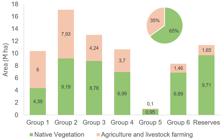
The Matopiba region is predominantly covered by native vegetation, with 25% of its area converted to agricultural use (Figure 2). Among the agricultural suitability groups, Group 2 (lands with regular suitability for crop cultivation) predominates, covering 17.12 Mha. Lands suitable for crop cultivation (good, regular or restricted suitability - Groups 1, 2 and 3, respectively) total 40.53 Mha, of which 18.17 Mha have already been converted to agricultural use. Areas unsuitable for agriculture or livestock farming, recommended for native vegetation maintenance or already designated as reserves, account for 19.71 Mha (of which 3.11 Mha have been converted).
Total area (Mha) of agricultural suitability groups and their percentage of use in the Matopiba region
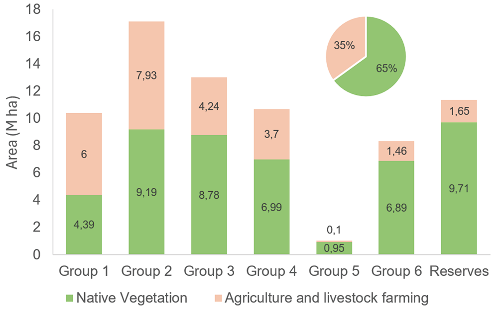
Group 1, with the highest agricultural suitability, is the only group where farming activity already predominates relative to its total area. Within these activities, livestock farming and accounts for 1.98 Mha, while agriculture 4.01 Mha (Figure 3). This ratio increases significantly in other groups still suitable for agriculture (Group 2, with 7 Mha of livestock farming and 0.94 Mha of cropland; Group 3, with 3.77 Mha of livestock farming and 0.47 Mha of cropland). This scenario reveals that, out of the total 18.17 Mha already in use on lands suitable for agriculture, 12.75 Mha are occupied by livestock farmings.

Distribution of land use classes within agricultural suitability groups in the Matopiba region
The conversion of land in Matopiba for cropland or livestock farming use has been widespread, but the most significant transformations occurred in the Bico do Papagaio region in Tocantins and the Cocais Forest in Maranhão. Both are lowland areas where native vegetation was primarily replaced by livestock farmland. In contrast, the plateau regions of Chapadões do São Francisco in Bahia and Alto Paranaíba in Piauí were predominantly converted to cropland (Figure 4).
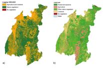
Land use changes in the MATOPIBA region- a) Deforestation from 1985 to 2023; b) Current land use and occupation
The advancement of deforestation continues at markedly different rates across agricultural suitability groups. As expected, the highest suitability group (Group 1) showed the greatest conversion of native lands to other uses and maintains the highest deforestation rates (Table 1). Considering the restrictions imposed by the Brazilian Forest Code,Law 12,651/2012 (BRAZIL, 2012), where Cerrado areas may be cleared up to 80% (maintaining 20% as Legal Reserves) and using an average annual deforestation rate (calculated from 2012 to 2023), it is estimated that in 16 years the convertible licensed Cerrado area will be extinct.
SUSTAINABILITY AND CHALLENGES IN AGRICULTURAL FRONTIER EXPANSION
The Cerrado's agricultural production is vital to Brazil's GDP, with Matopiba standing out as a major soybean, corn, and cotton producer. With approximately 4 Mha of soybean cultivation, the region produced a total of 18.5 million metric tons in the 2022/23 crop year, accounting for roughly 12.3% of Brazil’s total output (Embrapa, 2025). However, the high rates of native vegetation conversion raise concerns about production sustainability. Deforestation levels in the Cerrado now surpass even those in the Amazon biome (MapBiomas, 2024), and with the highest rates concentrated in Matopiba, the future of native vegetation cover-along with its critical ecosystem services-is under severe threat.
Native vegetation conversion in Matopiba reveals natural resource loss isn't tied to agricultural potential, indicating land underutilization or allocative inefficiency. This is starkly evident in highly suitable areas occupied by low-productivity livestock farmings - Cerrado's least productive land use, generating under one-third of total revenue (Abreu et al., 2013). Rada (2013) confirms this inefficiency, showing that while top farms boosted yields through technology, most properties expanded production mainly by clearing new land - an approach linked to rising production costs (Lima, 2019).
With growing international demand, the expansion of production and increased deforestation may seem inevitable. As predicted by Jevons’ Paradox, as resource use - in this case, land - becomes more efficient, its demand rises-and consequently, so does its consumption. However, countering this paradox, Carreira et al., (2024) demonstrate significant results from technological advances (e.g., the introduction of transgenic soybeans in the 2000s), which boosted productivity in previously unsuitable areas. This perspective suggests that deforestation could be curbed while increasing productivity in lands with marginal or restricted suitability, especially when supported by restrictive policies (Carreira et al.,2024; Ly, 2025).
Unlike the Amazon, where clandestine deforestation primarily drives livestock farming expansion on public or untitled lands (Torres et al., 2017; MapBiomas, 2024), hindering legal accountability, protective measures in the Cerrado could prove more effective for conservation. Here, deforestation is often linked to agricultural conversion, typically financed by public rural credit programs like those from Banco Nacional de Desenvolvimento Econômico e Social (Brazilian Development Bank - BNDES). In such cases, illegal native vegetation clearance without proper environmental permits can trigger land embargoes by state/federal agencies and suspension of rural credit access - a requirement recently codified in Banco Central do Brasil (Brazilian Central Bank) Resolution No. 5,193 (2024).
To enhance the effectiveness of these measures, it is essential that the provision of rural credit be contingent upon the establishment of activities compatible with the agricultural suitability of the land, as defined by technical mapping, and to avoid allocative inefficiency. However, should current deforestation rates persist, the eradication of native vegetation in areas of high agricultural suitability will become inevitable in the short term, even under the validity of the Forest Code. The projection that native vegetation in high agricultural suitability areas would endure for up to 16 years may be overestimated, given the accelerated pace of illegal deforestation, the ineffectiveness of applied sanctions, and the recurrent issuance of new licenses for vegetation suppression and rural credit concessions, even in cases of repeat offenses (Rajão et al., 2020).
Concurrently with the incorporation of technical agricultural suitability knowledge into environmental legislation, the application of stricter land-use restrictions is essential for maintaining sustainable agricultural production. Since lands with higher agricultural suitability are favorable for establishing various agriculture, with facilitated mechanization and consequently higher financial returns, these areas can be assigned more stringent use restrictions. In this context, a native vegetation retention proportion of 60% is suggested for Group 1 areas, instead of the 20% required by the Forest Code. This approach is expected to reduce deforestation rates to the point of maintaining viable Cerrado coverage for longer than currently estimated. This proportion could be associated with initiatives to restore degraded areas or those with significant environmental liabilities (Sano et al., 2019; Loyola et al., 2021).
Although vegetation cover maintenance is only recommended for Group 6 (unsuitable for agriculture and livestock farming), it is crucial to preserve it across various landscapes of the biome, as biodiversity distribution follows physical and biological attributes resulting from high heterogeneity. Species with greater affinity for more eutrophic soils, such as deciduous seasonal forests in the São Francisco River depression (Arruda et al., 2015; Bueno et al. 2018), occur in highly suitable lands but face intense land cover changes. This region is also considered the most demanding of environmental responsibility due to pressure on riparian vegetation (Sano et al., 2019). These riparian forests play a fundamental role in maintaining soil porosity and infiltration, watercourse quality, and especially biodiversity conservation (Nóbrega et al., 2020).
Transforming production systems in the Cerrado - and preserving more natural areas - is critical for addressing climate change impacts already affecting Brazil's agriculture. Native vegetation conversion in the biome drives localized climate shifts, altering rainfall patterns and raising regional temperatures (Leite-Filho et al. 2025). Climate suitability projections suggest much of Matopiba's Cerrado could resemble the Caatinga biome within 50 years (Arruda et al. 2024).
The impacts of land-use change on biodiversity, ecosystem services, and agricultural productivity are no longer future possibilities but present realities demanding immediate mitigation. Yet, the growing divide between environmental conservation and economic interests becomes increasingly apparent - particularly amid recent proposals to weaken environmental policies (Fernandes et al., 2025). The measures proposed here offer a pathway to maintain Brazil's robust agricultural productivity sustainably while helping bridge this gap.
A comprehensive analysis of Matopiba's land-use future must be expanded beyond linear projections to incorporate alternative scenarios that prioritize sustainable intensification and draw critical lessons from international experiences. A pivotal opportunity lies in the vast areas of degraded and low-productivity pastures, particularly those located on land classified with high agricultural suitability (Groups 1-3). Scenarios focusing on the conversion of these pastures into highly productive agricultural systems or integrated crop-livestock-forestry (ICLF) systems represent a quintessential "land sparing" strategy, potentially meeting production demands while significantly reducing the impetus for new deforestation (Strassburg et al., 2014; Garrett et al., 2018). This approach is further supported by economic models that indicate the potential for agricultural expansion without new clearings through the recovery of millions of hectares of degraded pastureland in Brazil. From an international perspective, valuable benchmarks can be drawn from the analysis of jurisdictional zero-deforestation agreements for cattle ranching in the Amazon, which highlight the critical importance of robust monitoring and supply chain transparency (Lerner et al., 2017) and territorial approaches to consolidate progress in slowing deforestation while providing a framework for addressing important dimensions of sustainable development (Nepstad, 2014). Similarly, examining the successes and challenges of territorial planning and economic incentives for forest conservation in the Moratoriums of the Chaco and Cerrado biomes (Lima; Persson, 2020; Heilmayr et al., 2020) offers critical insights into the governance mechanisms necessary to curb unsustainable expansion (Borras et al., 2012; Byerlee et al., 2017; Kröger; Anja, 2020). Incorporating these multifaceted scenarios and comparative analyses would transition the discussion towards a more nuanced and actionable exploration of pathways that reconcile agricultural development with the imperative of preserving Matopiba's threatened ecosystems.
FINAL CONSIDERATIONS
The Matopiba region contains the Cerrado's highest proportion of native vegetation yet exhibits the biome's highest deforestation rates. While deforestation is most severe in areas of highest agricultural potential, this land conversion fails to yield proportional gains in agricultural productivity, since native vegetation conversion has predominantly given way to livestock farmland - the activity with the lowest economic contribution. Considering the deforestation rate in areas of highest agricultural suitability (0.17 Mha/year), it is estimated that convertible licensed Cerrado areas will be exhausted within the next decade. This allocative inefficiency in the Cerrado results in both the loss of vital environmental resources and the underestimation of economic potential. To address this issue, it is imperative that environmental policies incorporate technical knowledge about land agricultural suitability, coupled with stricter land-use restrictions to ensure maintained agricultural productivity with sustainability.
DATA AVAILABILITY
The data that support the findings of this study can be made available, upon reasonable request, from the corresponding author [Daniel Meira Arruda].
REFERENCES
-
ABREU, U. G. P. de; GREGO, C. R.; FASIABEN, M. do C. R.; GOMES, E. G.; ALMEIDA, M. M. de; OLIVEIRA, O. C. de. Beef cattle stocking rate, a key to the conservation of the pastoral system in Brazilian biomes. In: INTERNATIONAL CONFERENCE ON AGRICULTURAL STATISTICS, 6., 2013, Rio de Janeiro. Anais [...]. Rio de Janeiro: IBGE, 2013. Available: http://www.alice.cnptia.embrapa.br/alice/handle/doc/1017878 Accessed on: fev. 20, 2025.
» http://www.alice.cnptia.embrapa.br/alice/handle/doc/1017878 -
ARRUDA, D. M.; SCHAEFER, C. E.; CORRÊA, G. R.; RODRIGUES, P. M.; DUQUE-BRASIL, R.; FERREIRA-JR, W. G.; OLIVEIRA-FILHO, A. T. Landforms and soil attributes determine the vegetation structure in the Brazilian semiarid. Folia Geobotanica, 50, 175-184, 2015. https://doi.org/10.1007/s12224-015-9221-0.
» https://doi.org/10.1007/s12224-015-9221-0 -
ARRUDA, D. M.; SCHAEFER, C. E.; FONSECA, R. S.; FERNANDES‐FILHO, E. I.; VELOSO, G. V.; GOMES, L. C.; SOLAR, R. R. Amazonian vegetation types and indigenous lands threatened by upcoming climate change: Forecast impact for Brazilian biomes. Austral Ecology, 49(1), e13369, 2024. https://doi.org/10.1111/aec.13369
» https://doi.org/10.1111/aec.13369 - BANCO CENTRAL DO BRASIL. Resolução CMD Resolução CMN n° 5.193, de 19/12/2024. Altera normas da Seção 9 (Impedimentos Sociais, Ambientais e Climáticos) do Capítulo 2 (Condições Básicas) do Manual de Crédito Rural - MCR. Banco Central do Brasil.
-
LIMA, M. G. B.; PERSSON, U. M. Commodity-centric landscape governance as a double-edged sword: the case of soy and the Cerrado Working Group in Brazil. Frontiers in Forests and Global Change. v. 3, 2020 https://doi.org/10.3389/ffgc.2020.00027
» https://doi.org/10.3389/ffgc.2020.00027 -
BEZERRA, J. E.; GONZAGA, C. L. O discurso regional do Matopiba no poder legislativo federal: práticas e políticas. Revista Nera, n.47, p. 46-63, 2019. https://doi.org/10.47946/rnera.v0i47.6265
» https://doi.org/10.47946/rnera.v0i47.6265 -
BORRAS, S. M.; FRANCO, J. C.; GÓMEZ, S.; KAY, C.; SPOOR, M. Land grabbing in Latin America and the Caribbean. The Journal of Peasant Studies, [S. l.], v. 39, n. 3-4, p. 845-872, 2012. https://doi.org/10.4324/9781315871806
» https://doi.org/10.4324/9781315871806 -
BUENO, M. L.; DEXTER, K. G.; PENNINGTON, R. T.; PONTARA, V.; NEVES, D. M.; RATTER, J. A.; DE OLIVEIRA‐FILHO, A. T. The environmental triangle of the Cerrado Domain: Ecological factors driving shifts in tree species composition between forests and savannas. Journal of Ecology, v. 106, n. 5, p. 2109-2120, 2018. https://doi.org/10.1111/1365-2745.12969
» https://doi.org/10.1111/1365-2745.12969 -
BYERLEE, D.; MASTERS, W. A.; ROBINSON, D. S. Land grabs or land development? In: PINGALI, P., FEDER, G. (ed.). Agriculture and Rural Development in a Globalizing World. 1. ed. New York: Routledge, 2016. p. 75-99. Available: https://www.taylorfrancis.com/chapters/edit/10.4324/9781315314051-4/land-grabs-land-development-derek-byerlee-william-masters-daniel-robinson Accessed on: fev. 15, 2025.
» https://www.taylorfrancis.com/chapters/edit/10.4324/9781315314051-4/land-grabs-land-development-derek-byerlee-william-masters-daniel-robinson - BRAZIL. Law No. 12,651, of May 25, 2012. Official Gazette of the Union: section 1, Brasília, DF, p. 1, may 28, 2012.
-
CARREIRA, I.; COSTA, F.; PESSOA, J. P. The deforestation effects of trade and agricultural productivity in Brazil. Journal of development economics, v. 167, 2024. https://doi.org/10.1016/j.jdeveco.2023.103217
» https://doi.org/10.1016/j.jdeveco.2023.103217 -
CHIARAVALLOTI, R. M.; TOMAS, W. M.; UEZU, A.; SHIRAI, H. Y.; GUARALDO, E.; AOKI, C.; SALVADORI, J. F. Rapid land use conversion in the Cerrado has affected water transparency in a hotspot of ecotourism, Bonito, Brazil. Tropical Conservation Science, v. 15, 2022. https://doi.org/10.1177/19400829221127087
» https://doi.org/10.1177/19400829221127087 -
COSTA, A. M.; VIANA, J. H.; EVANGELISTA, L. P.; CARVALHO, D. C.; PEDRAS, K. C.; HORTA, I. M.; SALIS, H. H.; PEREIRA, M. P.; SAMPAIO, J. D. Ponderação de variáveis ambientais para a determinação do Potencial de Uso Conservacionista para o Estado de Minas Gerais. Revista GEOgrafias, Belo Horizonte, v. 14, n.1, p. 118-133, junho, 2017. https://doi.org/10.35699/2237-549X..13439
» https://doi.org/10.35699/2237-549X..13439 -
COSTA, A. M.; SILVA, L. H.; SILVA, V. C.; MOURA, M. S.; MOTA, P. K.; ARAÚJO, B. J. R. S. Potencial de Uso Conservacionista (PUC) e Uso e Cobertura do Solo na Bacia Hidrográfica do Córrego Guavirá, PR. Revista Perspectiva Geográfica-Campus Marechal Cândido Rondon, v. 14, n. 20, p. 107-122, jul./dez, 2019. Available: https://e-revista.unioeste.br/index.php/pgeografica/article/view/24034 Accessed on: jan. 26, 2025.
» https://e-revista.unioeste.br/index.php/pgeografica/article/view/24034 -
COUTINHO, L. M. O conceito do Cerrado. Revista Brasileira de Botânica, v. 1, p. 17-23, 1978. https://doi.org/10.1590/S0102-33062006000100002
» https://doi.org/10.1590/S0102-33062006000100002 -
DUTRA, R. M. S.; SOUZA, M. M. O. D. Cerrado, revolução verde e evolução do consumo de agrotóxicos. Sociedade & Natureza, v. 29, n. 3, p. 469-484, 2017. https://doi.org/10.14393/SN-v29n3-2017-8
» https://doi.org/10.14393/SN-v29n3-2017-8 - EITEN, G. Vegetação do Cerrado. In: PINTO, M. N. (Org.). Cerrado: caracterização, ocupação e perspectivas. 2. ed. Brasília: Editora UnB, 1990. p. 9-65.
-
EMBRAPA, Sobre o Matopiba. 2025. Available: https://www.embrapa.br/tema-matopiba/sobre-o-tema Accessed on: mar. 20, 2025.
» https://www.embrapa.br/tema-matopiba/sobre-o-tema - ESRI ArcMap 10.8 Environmental System Resoration. California: Institute, Redlands, 2019.
-
ESPÍRITO-SANTO, M. M.; LEITE, M. E.; SILVA, J. O.; BARBOSA, R. S.; ROCHA, A. M.; ANAYA, F. C.; DUPIN, M. G. Understanding patterns of land-cover change in the Brazilian Cerrado from 2000 to 2015. Philosophical Transactions of the Royal Society: Biological Sciences, v. 371(1703), 2016. https://doi.org/10.1098/rstb.2015.0435
» https://doi.org/10.1098/rstb.2015.0435 -
FERNANDES, G. W.; RAMOS, L.; FERNANDES, S.; ADAMS, C.; ALENCAR, A. A. C.; ALMADA, E. D.; ANTONINI, Y.; ARAÚJO, F. S.; BARROSO, M.; BERGALLO, H. G.; BERTASSONI, A.; BORGES, J.; BOZELLI, R.; BUSTAMANTE, M.; CALADO, D.; CAMPOS, R. I.; CORNELISSEN, T.; COSTA, W.; COZZUOL, M. A.; DAMASCENO JUNIOR, G. A.; DE MARCO JUNIOR, P.; DIAS, C. P.; DICKINSON, B.; DINIZ FILHO, J. A. F.; FERREIRA, G. B.; FERREIRA, L. G.; FERREIRA, M. E.; FIGUEIRA, J. E. C.; GALLO, E.; GARCIA, L. C.; GOMES, I.; GONÇALVES, L. R.; GONZAGA, A. P. D.; GRELLE, C. E. V.; GUIMARÃES, L.; JACOBI, P. R.; JOLY, C. A.; JUEN, L.; KENEDY-SIQUEIRA, W.; KROLLOW, T. K.; LAUFER, J.; LEAL, C. G.; LOPES, F. A. C.; MACHADO, E. L. M.; MACHADO, F. F.; MARQUES, M.; MELLO, J. H. F.; MENDONÇA FILHO, C. V.; METZGER, J.; MOTA, F. M. M.; NEGREIROS, D.; NEVES, F. S.; NOBRE, C.; OKI, Y.; OLIVEIRA, F. L.; OLIVEIRA, R. P.; OVERBECK, G.; PAULA, G. A.; PEDRONI, F.; PERILLO, L. N.; PILLAR, V.; POLETTE, M.; QUEIROZ, H.; RAJÃO, R.; RIBEIRO, S. P.; ROCHA, C. Q.; RODRIGUES, D. J.; RODRIGUES, R. R.; ROQUE, F. O.; ROSA, C.; SABINO, J.; SANTOS, D. L.; SANTOS, J. C.; SANTOS, M. R.; SEIXAS, C. S.; SILVA, A. C.; SILVA, R. R.; SILVEIRA JUNIOR, E. G.; SOARES, M.; SOLAR, R.; SOUZA JUNIOR, W. C.; TABARELLI, M.; TELLES, M. P. C.; TOMA, T. S. P.; VAZ-DE-MELLO, F. Z. O Brasil em Risco: Os Impactos do PL 2159/2021 na Sustentabilidade e na Governança Ambiental, 2025. https://doi.org/10.6084/m9.figshare.29250836.v1
» https://doi.org/10.6084/m9.figshare.29250836.v1 - FEARNSIDE, P. M. Desmatamento na Amazônia Brasileira: História, Índices e Consequências. Megadiversidade, v. 1, n. 1, p. 113-123, 2005.
-
Flora e Funga do Brasil. Jardim Botânico do Rio de Janeiro. Available: http://floradobrasil.jbrj.gov.br/ Accessed on: apr. 12, 2025.
» http://floradobrasil.jbrj.gov.br/ -
FRANÇOSO, R. D.; BRANDÃO, R.; NOGUEIRA, C. C.; SALMONA, Y. B.; MACHADO, R. B.; COLLI, G. R. Habitat loss and the effectiveness of protected areas in the Cerrado Biodiversity Hotspot. Nature Conservancy. v. 13, p. 35-40, 2015. https://doi.org/10.1016/j.ncon.2015.04.001
» https://doi.org/10.1016/j.ncon.2015.04.001 -
GARRETT, R. D.; KOH, I.; LAMBIN, E. F.; DE WAROUX, Y. L. P.; KASTENS, J. H.; BROWN, J. C. Intensification in agriculture-forest frontiers: Land use responses to development and conservation policies in Brazil. Global Environmental Change, v. 53, p. 233-243, 2018. https://doi.org/10.1016/j.gloenvcha.2018.09.011
» https://doi.org/10.1016/j.gloenvcha.2018.09.011 -
GIROLDO, A. B.; SCARIOT, A. Land use and management affects the demography and conservation of an intensively harvested Cerrado fruit tree species. Biological Conservation, 191, 150-158, 2015. https://doi.org/10.1016/j.biocon.2015.06.020
» https://doi.org/10.1016/j.biocon.2015.06.020 -
HEILMAYR, R.; RAUSCH, L. L.; MUNGER, J.; GIBBS, H. K. Brazil’s Amazon soy moratorium reduced deforestation. Nature Food, 1(12), 801-810, 2020. https://doi.org/10.1038/s43016-020-00194-5
» https://doi.org/10.1038/s43016-020-00194-5 -
IBAMA. Desmatamento ilegal no Cerrado gera R$ 206 milhões em multas por descumprimento de embargos e impedimento da regeneração natural. Brasília, DF, 26 jan. 2024. Available: https://www.gov.br/ibama/pt-br/assuntos/noticias/2024/desmatamento-ilegal-no-Cerrado-gera-r-206-milhoes-em-multas-por-descumprimento-de-embargos-e-impedimento-da-regeneracao-natural Accessed on: mar. 20, 2025.
» https://www.gov.br/ibama/pt-br/assuntos/noticias/2024/desmatamento-ilegal-no-Cerrado-gera-r-206-milhoes-em-multas-por-descumprimento-de-embargos-e-impedimento-da-regeneracao-natural -
KLINK, C. A.; MACHADO, R. B. Conservation of the Brazilian cerrado. Conservation biology, v. 19 p. 707-713, 2005. https://doi.org/10.1111/j.1523-1739.2005.00702.x
» https://doi.org/10.1111/j.1523-1739.2005.00702.x -
KRÖGER, M.; NYGREN, A. Shifting frontier dynamics in Latin America. Journal of Agrarian Change, v. 20, p. 364-386, 2020. https://doi.org/10.1111/joac.12354
» https://doi.org/10.1111/joac.12354 -
LEITE-FILHO, A. T.; SOARES-FILHO, B. S.; OLIVEIRA, U.; COE, M. Intensification of climate change impacts on agriculture in the Cerrado due to deforestation. Nature Sustainability, v. 8, p. 34-43, 2025. https://doi.org/10.1038/s41893-024-01475-8
» https://doi.org/10.1038/s41893-024-01475-8 -
LERNER, A. M.; ZULUAGA, A. F.; CHARÁ, J.; ETTER, A.; SEARCHINGER, T. Sustainable cattle ranching in practice: moving from theory to planning in Colombia’s livestock sector. Environmental management, v. 60, p. 176-184. 2017. https://doi.org/10.1007/s00267-017-0902-8
» https://doi.org/10.1007/s00267-017-0902-8 -
LIMA, D. A. Terra, trabalho e acumulação: o avanço da soja na região Matopiba. 2019. Tese Doutorado em Geografia, Universidade Estadual de Campinas, 2019. https://doi.org/10.47749/T/UNICAMP.2019.1092294
» https://doi.org/10.47749/T/UNICAMP.2019.1092294 -
LOYOLA, R.; REZENDE, C.; RIBEIRO, B. Áreas prioritárias para conservação e restauração no MATOPIBA. Caderno de Notas Técnicas do Programa Parceria para o Bom Desenvolvimento (GGP/PNUD). Rio de Janeiro: Conservação Internacional Brasil, 2021. https://doi.org/10.48075/igepec.v27i1.30378
» https://doi.org/10.48075/igepec.v27i1.30378 -
LUMBRERAS, J. F.; CARVALHO FILHO, A.; MOTTA, P. E. F.; BARROS, A. H. C.; AGLIO, M. L. D.; DART, R.O.; SILVEIRA, H. L. F.; QUARTAROLI, C. F.; ALMEIDA, R. E. M.; FREITAS, P. L. Aptidão agrícola das terras do Matopiba. Rio de Janeiro: Embrapa Solos, 48 p. il. color. (Embrapa Solos. Documentos, 179), 2015. Available: http://www.infoteca.cnptia.embrapa.br/infoteca/handle/doc/1025303 Accessed on: mar. 25, 2025.
» http://www.infoteca.cnptia.embrapa.br/infoteca/handle/doc/1025303 -
LY, A. Financial globalization and tropical deforestation. Ecological Economics, v. 237, 2025. https://doi.org/10.1016/j.ecolecon.2025.108688
» https://doi.org/10.1016/j.ecolecon.2025.108688 - MACHADO, R. B.; RAMOS NETO, M. B.; PEREIRA, P. G. P.; CALDAS, E. F.; GONÇALVES, D. A.; SANTOS, N. S; TABOR K.; STEININGER, M. Estimativas de perda da área do Cerrado brasileiro. Relatório técnico não publicado. Conservação Internacional, Brasília, DF, 2004.
-
MAPBIOMAS Mapeamento Anual de Cobertura e Uso da Terra no Brasil - Coleção 9. 2024. Available: https://brasil.mapbiomas.org/wp-content/uploads/sites/4/2024/09/Factsheet-Cerrado_C9_17.09.24_FG-e-AG_v3.pdf Accessed on: apr. 28, 2025.
» https://brasil.mapbiomas.org/wp-content/uploads/sites/4/2024/09/Factsheet-Cerrado_C9_17.09.24_FG-e-AG_v3.pdf -
MARQUES, M. I. M.; LIMA, D. A. The expansion of agribusiness and territorial conflicts in the Cerrado of Central-North Brazil: The pillaging of land, water and native vegetation. In: ANTHIAS, P., FLORES, P. C. L. (ed.). Neoextractivism and Territorial Disputes in Latin America. 1. ed. New York: Routledge, 2023. p. 81-105. https://doi.org/10.4324/9781003267461
» https://doi.org/10.4324/9781003267461 -
MIRANDA, E. E.; MAGALHÃES, L. A.; DE CARVALHO, C. A. Proposta de Delimitação Territorial do MATOPIBA. Nota Técnica 1, 2014. Available: http://www.infoteca.cnptia.embrapa.br/infoteca/handle/doc/1037313 Accessed on: apr. 28, 2025.
» http://www.infoteca.cnptia.embrapa.br/infoteca/handle/doc/1037313 -
MYERS, N.; MITTERMEIER, R. A.; MITTERMEIER, C. G.; DA FONSECA, G. A.; KENT, J. Biodiversity hotspots for conservation priorities. Nature, 403(6772), 853-858, 2000. https://doi.org/10.1038/35002501
» https://doi.org/10.1038/35002501 -
NEPSTAD, D.; MCGRATH, D.; STICKLER, C.; ALENCAR, A.; AZEVEDO, A.; SWETTE, B.; BEZERRA, T.; DIGIANO, M.; SHIMADA, J.; SEROA DA MOTTA, R.; ARMIJO, E.; CASTELLO, L.; BRANDO, P.; HANSEN, M. C.; MCGRATH-HORN, M.; CARVALHO, O.; HESS, L. Slowing Amazon deforestation through public policy and interventions in beef and soy supply chains. Science, v. 344, n. 6188, p. 1118-1123, 2014. Available: https://www.science.org/doi/10.1126/science.1248525 Accessed on: apr. 28, 2025
» https://www.science.org/doi/10.1126/science.1248525 -
NÓBREGA, R. L. B.; ZIEMBOWICZ, T.; TORRES, G. N.; GUZHA, A. C.; AMORIM, R. S. S.; CARDOSO, D.; JOHNSON, M. S.; SANTOS, T. G.; COUTO, E.; GEROLD, G. Ecosystem services of a functionally diverse riparian zone in the Amazon-Cerrado agricultural frontier. Global Ecology and Conservation, v. 21, 2020. https://doi.org/10.1016/j.gecco.2019.e00819
» https://doi.org/10.1016/j.gecco.2019.e00819 -
OLIVEIRA, V. A.; SANTOS, G. G., KER, J. C.; COUTO, E. G.; JACOMINE, P. K.; CORRÊA, G. R.; CURI, N.; SCHAEFER, C. E. Soils of Cerrados, the Brazilian Savannas. In: The Soils of Brazil. Springer International Publishing, 2023. https://doi.org/10.1007/978-3-031-19949-3
» https://doi.org/10.1007/978-3-031-19949-3 -
PESSÔA, V. L. S., & INOCÊNCIO, M. E. O prodecer (re)visitado: as engrenagens da territorialização do capital no Cerrado. Revista Campo-Território, v. 9, 2014. https://doi.org/10.14393/RCT91826927
» https://doi.org/10.14393/RCT91826927 -
MAPBIOMAS. Annual Report of Deforestation in Brazil 2023. São Paulo: MapBiomas, 2024. Available: http://alerta.mapbiomas.org Accessed on: apr. 28, 2025.
» http://alerta.mapbiomas.org -
RADA, N. Assessing Brazil’s Cerrado agricultural miracle. Food Policy, v. 38, p. 146-155, 2013. https://doi.org/10.1016/j.foodpol.2012.11.002
» https://doi.org/10.1016/j.foodpol.2012.11.002 -
RAJÃO, R.; SOARES-FILHO, B.; NUNES, F.; BÖRNER, J.; MACHADO, L.; ASSIS, D.; OLIVEIRA, A.; PINTO, L.; RIBEIRO, V.; RAUSCH, L.; GIBBS, H.; FIGUEIRA, D. The rotten apples of agribusines. Science, 369(6501), 246-248, 2020. https://doi.org/10.1126/science.aba6646
» https://doi.org/10.1126/science.aba6646 -
RAMALHO-FILHO, A.; BEEK, K. J. Sistema de avaliação da aptidão agrícola das terras. 3. ed. rev. Rio de Janeiro: Embrapa-CNPS, 1995. Available: http://www.infoteca.cnptia.embrapa.br/infoteca/handle/doc/330132 Accessed on: apr. 28 2025.
» http://www.infoteca.cnptia.embrapa.br/infoteca/handle/doc/330132 -
RATTER, J. A.; BRIDGEWATER, S.; RIBEIRO, J. F. Analysis of the floristic composition of the Brazilian Cerrado vegetation III: comparison of the woody vegetation of 376 areas. Edinburgh journal of botany, v. 60, p. 57-109, 2003. https://doi.org/10.1017/S0960428603000064
» https://doi.org/10.1017/S0960428603000064 -
RODRIGUES, W.; VASCONCELOS, S. J.; BARBIERO, A. K. Análise da efetividade socioeconômica do PRODECER III no município de Pedro Afonso, Tocantins. Pesquisa Agropecuária Tropical, v. 39, n.4, p. 301-306. 2009. Available: https://revistas.ufg.br/pat/article/view/5581 Accessed on: apr. 12, 2025
» https://revistas.ufg.br/pat/article/view/5581 -
SANO, E. E.; RODRIGUES, A. A.; MARTINS, E. S.; BETTIOL, G. M.; BUSTAMANTE, M. M.; BEZERRA, A. S.; COUTO JÚNIOR, A. F.; VASCONCELOS, V.; SCHÜLER, J.; BOLFE, E. L. Cerrado ecoregions: A spatial framework to assess and prioritize Brazilian savanna environmental diversity for conservation. Journal of environmental management. v. 232, 818-828, 2019. https://doi.org/10.1016/j.jenvman.2018.11.108
» https://doi.org/10.1016/j.jenvman.2018.11.108 -
SCHMIDT, I. B.; FIGUEIREDO, I. B.; SCARIOT, A. Ethnobotany and effects of harvesting on the population ecology Syngonanthus nitens (bong.) ruhland (eriocaulaceae), a NTFP from Jalapão region, central Brazil. Economic Botany, v. 61, n. 1, p. 73-85, 2007. https://doi.org/10.1663/0013-0001(2007)61[73:EAEOHO]2.0.CO;2
» https://doi.org/10.1663/0013-0001(2007)61[73:EAEOHO]2.0.CO;2 -
SOARES-FILHO, B.; MOUTINHO, P.; NEPSTAD, D.; ANDERSON, A.; RODRIGUES, H.; GARCIA, R. Role of Brazilian Amazon protected areas in climate change mitigation. Proceedings of the National Academy of Sciences of the United States of America, 107, 10821-10826, 2010. https://doi.org/10.1073/pnas.0913048107
» https://doi.org/10.1073/pnas.0913048107 -
SOUZA, G. V. A. D.; PEREIRA, M. F. V. MATOPIBA: a Inteligência Territorial Estratégica (ITE) e a regionalização como ferramenta. Revista Nera, n. 47, p. 22-45, 2019. https://doi.org/10.47946/rnera.v0i47.6264
» https://doi.org/10.47946/rnera.v0i47.6264 -
SPAROVEK, G.; BERNDES, G.; BARRETTO, A. G. O. P.; KLUG, I. L. F. A revisão do Código Florestal Brasileiro. Novos Estudos - CEBRAP, n. 102, p. 111-135, jul. 2015. https://doi.org/10.1590/S0101-33002011000100007
» https://doi.org/10.1590/S0101-33002011000100007 -
STRASSBURG, B. B.; LATAWIEC, A. E.; BARIONI, L. G.; NOBRE, C. A.; DA SILVA, V. P.; VALENTIM, J. F.; VIANNA, M.; ASSAD, E. D. When enough should be enough: Improving the use of current agricultural lands could meet production demands and spare natural habitats in Brazil. Global Environmental Change, v. 28, p. 84-97, 2014. https://doi.org/10.1016/j.gloenvcha.2014.06.001
» https://doi.org/10.1016/j.gloenvcha.2014.06.001 -
TERRABRASILIS. Supressão da vegetação nativa para o Bioma Amazônia (Raster). 2025. Available: https://terrabrasilis.dpi.inpe.br/geonetwork/srv/eng/catalog.search#/metadata/c91f1d68-b5a5-455e-9d98-dd0573eb6ee0 Accessed on: apr. 28, 2025.
» https://terrabrasilis.dpi.inpe.br/geonetwork/srv/eng/catalog.search#/metadata/c91f1d68-b5a5-455e-9d98-dd0573eb6ee0 -
TORRES, M.; DOBLAS, J.; ALARCON, D. F. “Dono é quem desmata”: conexões entre grilagem e desmatamento no sudoeste paraense. São Paulo: Urutu-branco; Altamira: Instituto Agronômico da Amazônia, 2017. Available: https://site-antigo.socioambiental.org/sites/blog.socioambiental.org/files/nsa/arquivos/dono_e_quem_desmata_conexoes_entre_gril1.pdf Accessed on: sep. 15, 2025.
» https://site-antigo.socioambiental.org/sites/blog.socioambiental.org/files/nsa/arquivos/dono_e_quem_desmata_conexoes_entre_gril1.pdf
-
ASSOCIATE EDITOR
Silvio Carlos Rodrigues - 0000-0002-5376-1773

 Source:
  Source: Elaborated by the authors (2025).
 Source: Elaborated by the authors (2025).
