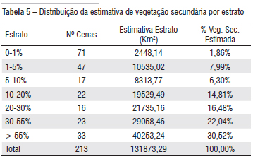
Secondary vegetation has many relevant functions to the ecosystems such as atmospheric carbon fixation , maintenance of biodiversity, establishment of connectivity among forest remnants, maintenance of hydrological regime, and restoration of soil fertility. The objective of this work is to estimate the area occupied by secondary vegetation in the Brazilian Legal Amazon (BLA) for 2006 using a sampling scheme. The sampling is based on a stratified approach according to the degree of deforestation observed in the 229 TM-Landsat scenes that cover the BLA. Thus, 26 scenes were selected for 2006 and distributed into seven strata, according to their degree of deforestation, in which secondary vegetation areas were mapped. A regression model was constructed to estimate secondary vegetation area in the remaining images using deforestation area, hydrographic area, agrarian structure , and area of conservation units, as independent variables. The regression analysis found an adjusted R2 of 0.84 and positive coefficients for the proportion of hydrography in the image (2.055) and for the agrarian structure (0.197), while negative coefficients for the degree of deforestation in the image (-0.232) as well as for the proportion of Conservation Unity(-0.262). Using the multivariate regression model, an area of 131,873 km² of secondary vegetation was estimated for the year of 2006. Applying a Monte Carlo simulation we estimated an uncertainty of approximately 12,445 km² .
Secondary Vegetation; Remote Sensing; Statistical Models; Geoprocessing; Land use Dynamic