
 Socioenvironmental vulnerability: an integrated analysis of sociodemographic and environmental data
Abstract
Climate change, the degradation of natural environments, and inadequate land use are all aggravating socioeconomic problems at a global scale. Understanding the link between these processes and socioeconomic conditions provides important insights for the development of more effective strategies for tackling these problems and adapting environmental policy. The present study describes the socioenvironmental vulnerability of areas affected by hydrological events in the central Brazilian city of Goiânia, the capital of Goiás state. For this, data on flooding events provided by the Civil Defense Corps were mapped in relation to social vulnerability, which was defined based on census data on infrastructure, social conditions, and income, extracted from the IBGE Automatic Recovery System, following the assumptions of Santos et al. (2017) and Cunico et al. (2021). In Goiânia, infrastructure and social factors accentuate vulnerability, while income is the principal factor determining a reduction in vulnerability. The mapping of socioenvironmental vulnerability from a socioeconomic perspective is fundamental to adequate urban planning, and the development of effective responses capable of reinforcing local resilience to environmental threats that are recurring with increasing frequency.
Keywords:
Hazard; environmental risk; hydrological disasters; census sectors; urban planning
Resumo
As mudanças climáticas, a degradação dos ambientes naturais e o uso inadequado do solo agravam problemas socioeconômicos em escala global. Relacionar esses fatores à condição socioeconômica contribui para estratégias mais eficazes de enfrentamento e adaptação. Esta pesquisa teve como objetivo caracterizar a vulnerabilidade socioambiental em áreas afetadas por eventos hidrológicos em Goiânia (GO). Para isso, sobrepuseram-se dados de alagamentos, fornecidos pela Defesa Civil, à vulnerabilidade social, definida com base em variáveis censitárias de infraestrutura, condições sociais e renda, extraídas do Sistema IBGE de Recuperação Automática, seguindo pressupostos de Santos et al. (2017) e Cunico et al. (2021). Em Goiânia, a infraestrutura e fatores sociais elevam a vulnerabilidade, enquanto a renda é determinante na redução. O mapeamento da vulnerabilidade socioambiental com enfoque socioeconômico é fundamental para orientar o planejamento urbano, qualificar ações de resposta e fortalecer a resiliência local frente às ameaças ambientais cada vez mais recorrentes.
Palavras-chave:
Perigo; risco ambiental; desastres hidrológicos; setores censitários; planejamento urbano
Resumen
El cambio climático, la degradación de los entornos naturales y el uso inadecuado del suelo agravan los problemas socioeconómicos a escala global. Relacionar estos factores con la condición socioeconómica contribuye a estrategias más eficaces de enfrentamiento y adaptación. Esta investigación tuvo como objetivo caracterizar la vulnerabilidad socioambiental en áreas afectadas por hydrological events en Goiânia (GO). Para ello, se superpusieron datos de inundaciones, proporcionados por la Defensa Civil, con la vulnerabilidad social, definida a partir de variables censales de infraestructura, condiciones sociales y renta, extraídas del Sistema IBGE de Recuperación Automática, siguiendo los supuestos de Santos et al. (2017) y Cunico et al. (2021). En Goiânia, la infraestructura y los factores sociales aumentan la vulnerabilidad, mientras que el ingreso es determinante en su reducción. El mapeo de la vulnerabilidad socioambiental con enfoque socioeconómico es fundamental para orientar la planificación urbana, calificar las acciones de respuesta y fortalecer la resiliencia local frente a las amenazas ambientales cada vez más recurrentes.
Palabras-clave:
Peligro; riesgo ambiental; deisasteres hidrológicos; sectores censitaários; planificación urbana
Introduction
Worldwide, climate change, the degradation of natural environments, and inadequate land occupation and use have amplified progressively the widespread economic, social, and environmental problems that afflict the planet. As the occurrence of environmental disasters increases precipitously, social inequalities become ever more accentuated, and areas of environmental risk expand progressively. In the urban environment, population growth further exacerbates these trends.
Currently, more than half (55%) of the world’s population lives in urban areas, a proportion that is predicted to reach 70% by 2050, when approximately two-thirds (70%) of the global population will be found in cities (United Nations, 2018). This trend is even more accentuated in Brazil, where 85% of the population already resides in urban areas, increasing to 90% in the Midwest region, and 93% in the Southeast (Instituto Brasileiro de Geografia e Estatística [IBGE], 2015).
In addition to population growth, factors such as geomorphology, climate, soils, vegetation, and watercourses need to be taken into account for effective urban planning, given that they may all interfere considerably in the environmental quality of cities and their susceptibility to extreme events (Gonçalves et al., 2022).
As hydrological events such as inundations, flooding, and flash-floods can have impacts of varying magnitude, in particular for the most vulnerable sectors of the population (Cunico & Lohmann, 2017), the identification of risk factors is essential for the control and prevention of these environmental processes (COMPDEC, 2020/2021). Understanding the social vulnerability, both of the areas of origin of the impacts and those affected directly by these impacts, is also essential for the systematic analysis of the dynamics of these processes.
This is because the potential for damage is directly proportional to the correlation between these factors, a condition defined as socioenvironmental vulnerability (Hogan et al., 2001). Given this, the identification of these phenomena, and the discussion of the socioeconomic reality of the affected groups, provides an “analytical alternative” for the understanding of their capacity for mobilization and the eventual response of the vulnerable groups in the context of their environmental susceptibilities (Cunico & Lohmann, 2017).
In this context, the present study focuses on the socioenvironmental vulnerability of urban areas affected by hydrological events in the city of Goiânia, capital of the central Brazilian state of Goiás. The findings of the study provide important insights for the understanding of the relationship between environmental hazards, the social conditions of the population, and its capacity to respond to these events.
CONCEPTUAL BASELINE
Socioenvironmental vulnerability and the use of indices to assess its impact
The term “socioenvironmental” was proposed to emphasize the proportionality of the relationship between society and nature, in particular in developing nations (Mendonça and Lima. 2020). These authors emphasize that the “socio” prefix is associated with the environment in such a way as to highlight the role of society as the subject, an inseparable element in the discussion of environmental problems. The specific term “socioenvironmental vulnerability” first arose in the 1980s, when social conditions began to be taken into account in the analysis of the distribution and extent of natural threats (Maior & Cândido, 2014). From the perspective of the Social Sciences, vulnerability is understood as the ways in which a diversity of phenomena have differential impacts on different individuals or social groups. In this context,
[f]actors such as income levels, education, age, gender, access to public services, housing, and political participation may accentuate their predisposition to the occurrence of damage of varying orders of magnitude, including their own death, as well as expressing their capacity to cope with crisis and to make the most of opportunities for the improvement of their wellbeing (Olímpio & Zanella, 2017, p. 102).
Watts and Bohle (1993) define vulnerability as the varying, unequal degrees of risk to which different social classes are exposed. These varying levels of vulnerability may be determined by both natural and anthropogenic factors, which influence the capacity of the distinct social groups to respond to extreme events.
Liverman (1990) concluded that vulnerability is associated with the biophysical conditions that influence the places and populations exposed to risks. However, Marandola and Hogan (2009) argue that associating vulnerability exclusively with poverty constitutes a limited perspective. This approach ignore the capacity of the communities to deal with situations of vulnerability, manage risks, and occupy spaces in a strategic manner.
From the viewpoint of the Natural Sciences, by contrast, vulnerability can be seen as the fragility of an area, including its soils and dams, and its potential for damage when exposed to some specific form of human action (Figueirêdo et al., 2007).
The degree of vulnerability of a community is related directly to the interaction between the environment and society, and its capacity to respond to adverse events, which is determined by a combination of diverse factors that influence the level of risk. Santos et al. (2017) argue that this approach elevates the concept of socioenvironmental vulnerability to the level of a conceptual theme that can be discussed academically.
Cutter (2011) defines socioenvironmental vulnerability as the probability that a group or individual will be exposed or impacted directly by a hazard. This vulnerability results in the interaction between the specific risks of a given place and the social profile of the communities that inhabit this space. Santos et al. (2020) and Alves (2021) pointed out that areas surrounding bodies of water have tended to be occupied, historically, by socially vulnerable groups, which exposes them to the intense oscillations in water levels resulting from extreme precipitation events, associated with compounding factors such as the impermeabilization of the soil and the suppression of the native vegetation.
Alves and Torres (2006) concluded that operational approaches for the assessment of social vulnerability based almost exclusively on monetary criteria, such as the poverty threshold, are extremely limited. This is because other factors, such as infrastructure and education, also influence the vulnerability of a group to natural events. In other words, vulnerability cannot be reduced solely to the level of monetary income, but rather, it involves aspects such as economic stability, gender, education, stable employment, infrastructure, and the quality of the services available in the neighborhood in which the individuals reside. This highlights one of the most relevant aspects of this approach, that is, the overlap between risks and environmental and social problems, which represents a major challenge for the development of adequate public policy, policy that is all too often compartmentalized in distinct areas of sectorial intervention.
Maior and Cândido (2014) emphasize the need for the improvement of study procedures in environmental research, highlighting the importance of relating environmental variables to the indices that reflect the exposure of a community to natural risks in the urban space, such as floods and landslides. The term “socioenvironmental vulnerability” is polysemic and has been applied amply in the sciences. Understanding, measuring, and classifying socioenvironmental vulnerability are all essential to advance research and improve the living conditions of the population by supporting the development of adequate public policy for the prevention of environmental disasters.
The concept of vulnerability adopted in the present study is that proposed by Cutter (1993), who defines this concept as the interaction between the hazards of a place and the social profile of the local communities. The study also considers the concepts of risk and hazard to be complementary, but not equivalent, following the reflections of Castro (2000) and Lourenço (2014). This focus aims to contribute to the type of multidimensional approach supported by Marandola Jr. and Hogan (2004), which provides important insights into the natural dynamics of the environment, its risks and hazards, with the aim of guaranteeing positive impacts for the conditions of life of the urban society.
Hydrological disasters: from the degree of exposure to risk management
According to the International Disaster Database, between the 1960s and 2009, almost 80% of the catastrophes and economic losses that occurred in South American countries were the result of hydrometeorological disasters, of which, floods were the most common type of event (Nunes, 2015).
A total of 58,883 environmental disasters were recorded in Brazil between 1991 and 2019, which affected 4,971 different municipalities and almost 248 million people, and caused 4,065 deaths. Approximately 90% of these disasters were derived from hydrological phenomena, based on data from the Digital Atlas of Disasters in Brazil (UFSC, 2020).
Over the past 30 years, the definition of disasters, previously considered to be of natural origin, has focused increasingly on socioenvironmental processes, with vulnerability being associated directly with these events. In this context, the notion of risk becomes increasingly relevant in the present-day scenario, given the complexity and intensification of the problems that arise from these risks, in addition to their broad reach in contemporary society. As Mendonça points out,
[i]n order to consider risks, and in particular the management of risks, they should be seen as part of a triad that is also formed by vulnerability and resilience. From this perspective, it is important to note that this approach involves not only the theoretical-conceptual and methodological conceptions of the terms of use, but also their practical applications, and the results of these applications in the management of the disasters that impact society (Mendonça, 2021, p. 15).
For Almeida (2012), this complex relationship among the theoretical-conceptual and methodological, and managerial approaches arises from the intrinsic complexity of contemporary society, which is permeated by uncertainty, fear, and insecurity. In the conceptual perspective of Brüseke (1997), risk, in the environmental field, is not seen as a deterministic chain of events that leads to a predictable result, but rather, linear movements that culminate inevitably in catastrophes or irreparable damage. By contrast, Smith (1992) defined risk as a probabilistic factor, independently of its quantification.
Veyret (2003) argues that risk is a social construct, which can be defined as the perception of danger. This argument infers that risk can only exist where an individual or population perceives it and, consequently, suffers its effects.
The combination of social, economic, cultural, demographic, and natural factors, which are inherent to the relationships among individuals and social groups, and between these actors and nature, results in the manifestation of the condition of risk (Mendonça, 2021). Almeida (2021, p. 41) also supports this approach, when they conclude that “exposure is a determinant of necessary risk, but not an exclusive one”, given that vulnerability is an integral component of the condition. In this case, risks are of a hybrid nature. Mendonça (2021) argues that hybrid risks originate from the association between two or more specific risks (e.g., natural, social, technological), which are intensified by the imbrication by the different elements and a range of other factors.
Similarly, Marandola Jr. and Hogan (2004) describe hazard as one of the components of risk, that is, a potential threat to individuals and their possessions. From a geographic perspective, then, risks and hazards are closely related to the manner in which social groups transform and use space, with the relationship between humans and the environment being inseparable in the context of the conceptualization of these terms. In this context, the conceptualization of hazard can be considered to be a threshold of transition between risk and crisis, in other words, hazard corresponds to the situation in which a risk shifts from latent to manifest (Lourenço, 2014). Given this, the contextualization and identification of hazards, and the mapping of social vulnerabilities, are fundamentally important guidelines for the development of mitigatory measures (Marandola Jr. & Hogan, 2006).
However, the subject of disaster risk reflects a political perspective that highlights the contradictions between urban planning for the monitoring and control of risk factors for the inhabitants of cities and the effective capacity of city councils to deal with these problems (Valêncio, 2021). While hazard equates to the manifestation of a crisis, the identification and mapping of its occurrence and recurrence does not consist of the direct suppression of its existence, but rather, the reduction of its potential effects through the understanding of the processes that stimulate these events and the installation of effective measures for the implementation of an anticipatory culture in response to the potential risks that exist in a specific area.
METHODS
Research design
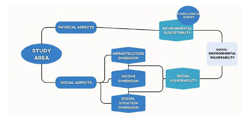
The present study followed the methodological guidelines of the studies of Alves (2006), Alves and Torres (2006), and Cunico et al. (2021). This approach permitted the empirical operationalization of the socioenvironmental vulnerability of the population resident in the study area in the Brazilian city of Goiânia (Figure 1).
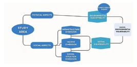
The approach adopted here is based on the identification of areas subject to a range of adverse environmental events, specifically floods, and their overlap with social vulnerability. The theoretical approach uses the concept of hazard, rather than risk, given that it focuses on areas already known to be affected by flooding, which were identified using the biannual report of the Goiânia Civil Defense Corps (2021). Social vulnerability was assessed based on the analysis of three socioeconomic dimensions (infrastructure, income, and social circumstances) based on the 2010 census data. Socioenvironmental vulnerability was identified as the spatial overlap of the different aspects of environmental susceptibility and the socioeconomic condition of the population exposed to the impact (Cutter, 1993).
Procedures
The areas of environmental susceptibility were mapped using data from the 2020/2021 biannual report of the Goiânia Municipal Coordination Center of Protection and Civil Defense Corps (2022) and Google Earth, with the hydrological events being plotted and processed in a Geographic Information System (GIS). As the report does not differentiate events of waterlogged drainage from flooding, the events were mapped without this distinction, with only the occurrence of an event being used as the criterion for the definition of susceptible areas. The analysis was applied to the urban area of Goiânia, without considering the environmental susceptibility of the municipality as a whole.
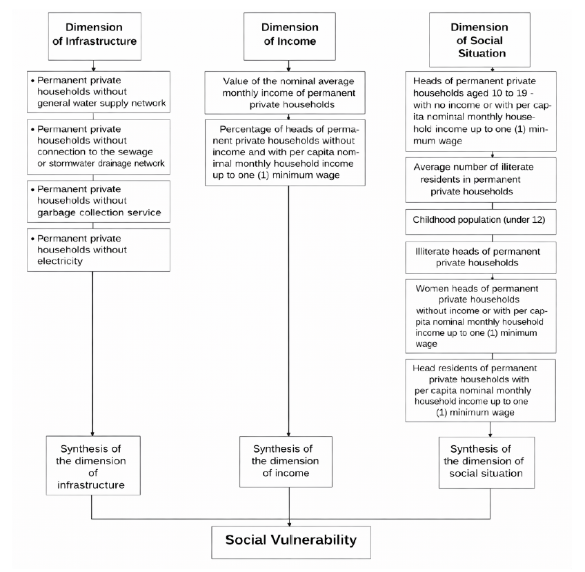
Social vulnerability was identified based on the census variables that reflect the infrastructure, social conditions, and income, with the data being extracted directly from the IBGE Automatic Recovery System (SIDRA2). These variables were arranged in five classes of equal amplitude, which represented the total universe of the urban area of the city of Goiânia. The variables were selected for each dimension based on the flow chart shown in Figure 2.
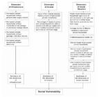
Flow chart of the methodological procedures adopted for the analysis of social vulnerability
As the variables used to operationalize social vulnerability were quantified using distinct units of measurement, it was necessary to standardize the values to a common scale, following Santos et al. (2017) and Cunico et al. (2021). The data were standardized using the Min-Max equation (Equation 1), which was applied to all the variables selected for analysis, except for “mean household income”, in which case, Equation 2 was applied. This was because this variable behaves in a contradictory manner in comparison with all the other parameters, that is, the higher the income, the lower the vulnerability of the specific group.
where:
Ips = standardized value of variable “I” in census sector “s”
Is = value of variable “I” in census sector “s”
I-v = lowest value of variable “I” in the universe of census sectors, and
I+v = highest value of variable “I” in the universe of census sectors
The dimensions were weighted following Cardoso (2023).
For the analysis of the association among the variables, that is, the aspect of their dimensions (Figure 2), the data were standardized using Equation 3. Equation 1 was applied once again to the ranking of vulnerability, that is, the relative contribution of the different dimensions.
where:
Isj = result of the index in census universe “s” sampled here
ai = weighting of the i-th variable
xij = value of the i-th variable observed for the j-th variable; and
ni = number of dimensions
These adjustments were necessary for the operationalization of the socioenvironmental vulnerability through the analysis of the mapping of the environmental (hydrological events) and socioeconomic (social vulnerability) data using the overlayer-overlap technique in the GIS environment. For this analysis, socioenvironmental vulnerability was classified in five categories - (i) very low, (ii) low, (iii) moderate, (iv) high or (v) very high, following Cunico et al. (2021).
The areas subject to hydrological events, that is, environmentally susceptible environments, were also considered in this analytical approach. It is important to note that socioenvironmental vulnerability, as defined here, refers specifically to the areas impacted by hydrological events. The cartographic database used for the maps presented here (see Results section) was that of IBGE (2010), given that the census data correspond to this temporal profile.
RESULTS AND DISCUSSION
Susceptibility of the environment to hydrological events
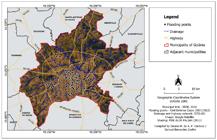
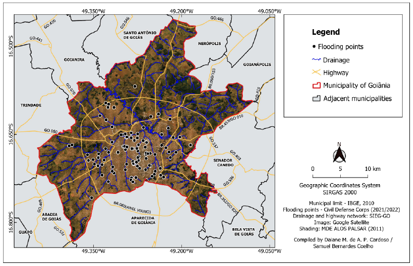
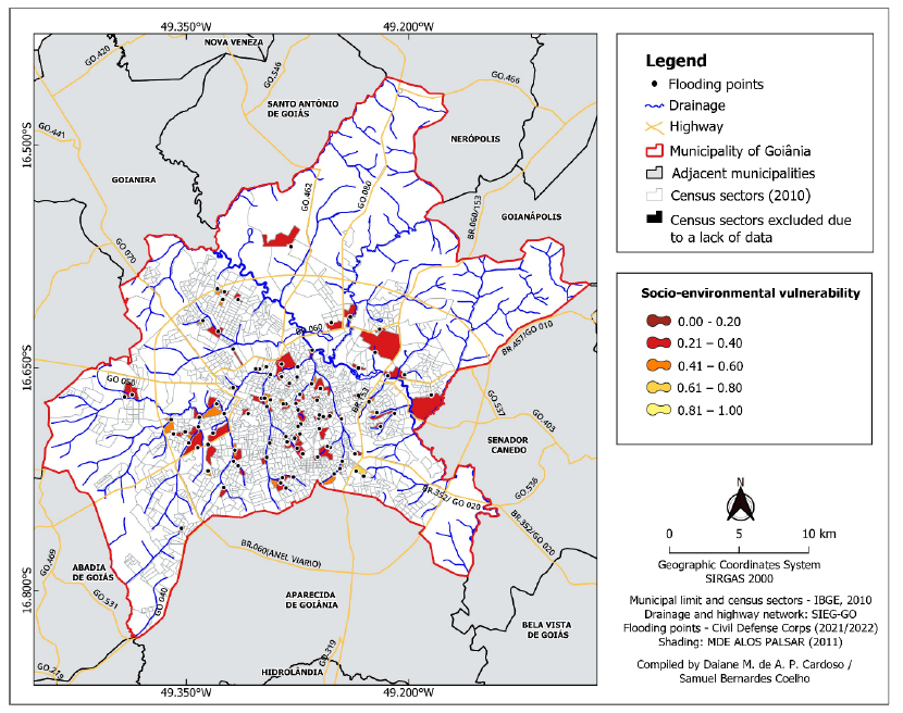
The data used in this first stage of the analysis were obtained from the database of the Goiânia Civil Defense Corps (Goiânia, 2021), which identifies 99 points subject to flooding in the city, that are currently being monitored (Figure 3). The southern region of Goiânia has the largest number of points (28), followed by the central region, with 21 points.
In the southern region, the Parque Amazonas sector has the largest number of recorded events, followed by the Bueno sector, while in the central region, the most events were recorded in the Centro sector. The Parque Amazônia and Bueno sectors are neighborhoods that were established in the 1950s and are still expanding. The data from the 2010 census indicate that these three sectors are among the most populous of the city of Goiânia, with 24,204 (Parque Amazonas), 20,907 (Bueno), and 39,394 (Centro) inhabitants.
In the other sectors of Goiânia, the Civil Defense report highlighted some other areas with a high risk for the occurrence of hydrological events, in particular the Vila Roriz sector, in the northern region, which is located on the floodplain of the Meia Ponte River and has a population that suffers from periodic flooding (Cunha, 2007). Alves (2013) concluded that areas on the margins of watercourses, which are subject to flooding and/or exposure to waterborne diseases, tend to reinforce a scenario of socioenvironmental vulnerability, with children of less than 4 years of age being most vulnerable to these pathogens.
In their quantitative analysis of the hydrological events recorded in the city of Goiânia, based on press reports and the Civil Defense database, Rego and Barros (2014) identified the occurrence of 64 hydrological events between 2003 and 2006, and 74 events between 2006 and 2010. The sectors most affected by these events were Bueno, Jardim Guanabara I and II, Jardim América, Urias Magalhães, Pedro Ludovico, and Campinas. The present study added the Parque Amazônia sector to the list of the most affected areas, which is consistent with the findings of these authors, who noted an increase in the occurrence of hydrological events in neighborhoods that were already well established by the end of the 1980s.
The occurrence of these phenomena is related directly to the pattern of land occupation and use, and its deviations from the norm, given that, while this process is often planned, when supported by real estate developers, it may also occur through pressure on the socioeconomically most vulnerable sectors of the population. The Parque Amazônia neighborhood, in the southern region of the city, is an example of the former process, where real estate developers have been investing in urban infrastructure since the 2000s. By contrast, the Jardim Emanueli estate, located in Jardim Novo Mundo 2, corresponds to an area occupied illegally, which lacks public sanitation or street lighting, and is located near the margins of the Buritis Stream.
Social vulnerability in the urban area of Goiânia
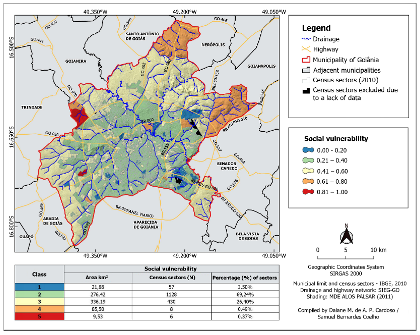
Social vulnerability was defined based on the 2010 census data obtained from the Brazilian Institute for Geography and Statistics (IBGE). While Goiânia has a total of 1636 census sectors, only 1629 were included in the present analysis, given that no data were found for seven of the sectors.
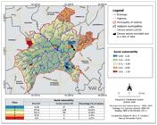
Social vulnerability was very high in six (0.37%) of the census sectors, affecting a total of approximately 1267 residents, that face extreme adversities, such as a lack of income, economic stability, education, jobs, and adequate services (precarious urban infrastructure or housing). According to the approach applied here, a further 2202 residents are currently at a high level of social vulnerability, while 330,053 residents were assigned to the moderate social vulnerability class.
The low social vulnerability class was the most numerous, with a total of 920,115 residents, in a universe of 1128 census sectors. It it important to note here that the unit of analysis (census sector) does not coincide exactly with the delimitation of the neighborhoods within the study area. This means that, in some cases, scenarios of high social vulnerability juxtapose with others of low vulnerability, which results in a mean classification that does not necessarily reflect the reality of the sector.
In addition, as Goiânia has extensive areas of profound social inequality and the limits of the census sectors do not coincide with those of the most deprived communities, a given census sector may include households of both low and high social vulnerability (Medeiros and Almeida, 2015). When these households are combined in the analysis, the result can be a median social pattern, which means that the analysis of the census data can face major challenges for the reliable definition of socioeconomic aspects (Canil, 2021).
Goiânia is a city of marked social contrasts, where buildings with precarious infrastructure can be found alongside large condominiums or middle or upper middle class neighborhoods. Examples include the Jardim Goiás sector, which has some of the most expensive real estate in the city of Goiânia, and the Parque Amazônia sector, which was developed originally for the city’s low-income population, but eventually began to attract middle-class residents following improvements to its infrastructure.
Goiânia was classified as one of the most socially unequal major Latin American cities by ONU HABITAT (2012). In this context, the factor income represents an important mechanism of social emancipation in response to environmental phenomena, given that financial resources can guarantee the capacity of the individual to react in response to an event. In this case, a society with a less unequal distribution of income will be more resilient, in contrast with a more unequal society, which will be much less resilient or even incapable to respond to these phenomena.
In addition to the economic factor, an essential alternative strategy for the improvement of the adaptive capacity of a population faced with recurrent extreme events is the effective integration of environmental criteria and urban zoning, through a General Urban Ordinance Plan (GUOP) that takes the local socioenvironmental dynamics into account. The need to articulate urban planning with environmental management is increasingly evident, given that urban socioenvironmental conflicts highlight and accentuate processes of sociospacial exclusion (Haesbaert, 2004). This approach forces the ordinance plan to transcend its normative function by taking on a political and redistributive role, which promotes socioterritorial equitability and does not neglect peripheral or environmentally fragile areas or those occupied by vulnerable populations (Rolnik, 2009).
The development of more just and resilient cities requires the recognition of environmental fragilities and vulnerabilities, which should be a central theme of urban planning. The results of the analysis of social vulnerability presented here indicate that Goiânia can be considered to be regular in terms of its infrastructure, income, and socioeconomic aspects. However, a more detailed assessment of the specific points that compile these general parameters indicates that the regular indices observed here for the urban area as a whole may obscure localized inequalities of vulnerability.
Given this, it is necessary to better understand sectorial and regional dynamics for a more conclusive general discussion. In fact, it is clear that more investment in research is a priority here, in order to provide more systematic insights into local dynamics, and the heterogeneity of vulnerable environments.
Socioenvironmental vulnerability to hydrological events
In the present study, socioenvironmental vulnerability was classified as very low, low, moderate, high or very high. The findings of Rebelo (2003) indicate that, irrespectively of this classification or the method used, vulnerability will always exist, and should always be analyzed together with the parameters of risk, hazard, and disaster.
The definition of socioenvironmental vulnerability provides important insights into how the shortage of resources faced by a community or group may affect the quality of life of its residents. This enables the association of scenarios of environmental susceptibility to natural events with the data on the socioeconomic aspects and infrastructure of a given region (Figure 5).
Overall, the areas identified as having very low socioenvironmental vulnerability correspond to only 1.01% of the points of occurrence of the hydrological events, while those of low vulnerability correspond to 72.73% of the points, and moderate vulnerability, to 24.24%. Areas of high socioenvironmental vulnerability correspond to only 2.02% of the points of occurrence of the hydrological events, while no association was found with areas of very high socioenvironmental vulnerability.
Farias and Mendonça (2022) found that the neighborhoods with the highest indices of risk and socioenvironmental vulnerability are located in peripheral regions of the municipality of Goiânia. These areas also have the highest indices of social vulnerability which, when associated with areas at risk of flooding, have the highest indices of socioenvironmental risk.
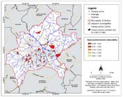
Efforts to reduce socioenvironmental vulnerability do not consist solely of attempts to reduce hazardous situations, but also the need to minimize the possible effects of these potential disasters through the understanding of the processes and the implementation of the necessary mitigatory measures, ranging from policies of social inclusion to municipal drainage planning. In this context, Nascimento (2015) draws attention to the increasing environmental impacts that the city of Goiânia has been exposed to due to its population growth and rapid urban expansion. This author refers to a series of problems, such as the appearance and amplification of a range of erosive processes, the modification of the urban climate and the consolidation of the urban heat island, and the recurrence and intensification of hydrological events, as well as increasing temperatures, decreasing relative humidity, and the loss of vegetation cover, as recorded in the present study.
The recently-passed municipal legislation that regulates the general ordinance plan of the city of Goiânia includes some legislative decisions that contradict the principles of the prevention of risks and disasters, such as the text that describes areas considered to be environmentally susceptible, and assets that are in the national interest, such as hilltops. In the new text, hilltops are defined as areas of an altitude of at least 100 meters, with a slope of more than 25%, but excluding sheerer terrain, with a slope of more than 45%, which would exclude the Mendanha and Serrinha hills, and areas in the vicinity of the BR 153 federal highway, as well as the João Leite River, all of which were protected by the previous ordinance plan. The new text also modifies the definition of the areas of environmental protection associated with bodies of water, which are now measured from the edge of the regular channel of the riverbed, as defined in article 143 of the new law.
Environmentally fragile areas are often overlooked in municipal ordinance plans, which contributes to their occupation by populations of high and very high social vulnerability. This reflects the lack of an integrated approach to urban planning that should include environmental considerations, as well as a lack of socioenvironmental justice.
The new general ordinance plan also supports the possibility of further urban expansion, given its amplification of the macrozoning of existing built-up areas. This contradicts the perspective of the previous plan, which emphasized the importance of improving the infrastructure in the urban areas that already exist. This aspect of the new plan represents an alarm call in terms of the potential scenarios of risk and disaster.
The most recent data published by the IBGE (2022) show that the population of Goiânia has grown 10.39% since 2010, to reach 1,423,237 inhabitants. These residents will hope that the city that is now reaching its first centenary will not only be the “Goiânia of the future”, as promoted by the City Council, in its media campaign, but also the Goiânia of the present-day, that is, small in its inequality, but large in its inclusiveness.
Conclusions
The mapping of the hydrological events, presented here, revealed that they occur predominantly in urban areas, with consolidated regions or neighborhoods concentrating the largest numbers of records.
Overall, 46% of the area of Goiânia was classified as having moderate social vulnerability, affecting a total population of 330,053 inhabitants. A further 25% of the population faces situations of social vulnerability that vary from high to very high. By contrast, the indices of very low social vulnerability are concentrated primarily in the areas occupied by luxury condominiums.
In the analysis of hydrological events, the results indicated that infrastructure and the social scenario contributed most to the condition of high socioenvironmental vulnerability, while the income dimension contributed most to the status of low socioenvironmental vulnerability.
Overall, then, the socioenvironmental vulnerability of the study areas is classified as moderate. Given this, despite a significant capacity of response to hydrological events, there is also a considerable level of exposure to hazards. In this scenario, the absence or ineffectiveness of the public authorities - which should monitor the growth and development of the city - in the management of these areas, in particular in terms of population growth, land use and cover, and their infrastructure, may lead to the transformation of neighborhoods currently considered to be of moderate vulnerability into areas of high or even very high socioenvironmental vulnerability.
These findings contribute further to the discussion of socioenvironmental vulnerability, especially from the perspective of hazards, by associating socioeconomic aspects with the factors that trigger recurrent environmental disasters in urban areas. These findings should also contribute to the technical decisions made by municipal organs, including the directorship of the Civil Defense Corps of the municipality of Goiânia, given that the results of this study can provide diagnostic insights for the development of environmental projects.
This study also provides guidelines for public policy, as well as a theoretical reference for urban planning, based on medium- to long-term measures for education and the prevention of environmental disasters, in order to create a city that is less susceptible to environmental problems.
Data on hazards related to socioeconomic parameters and their distribution are effective tools for the preparation of both the public authorities and the population for environmental disasters. In fact, these data can be used to compile a practical agenda by the municipal authorities, focusing on the prevention of environmental disasters.
The results of the present study highlight the need for further research that analyzes socioenvironmental vulnerability with a focus on socioeconomic parameters at a sector or neighborhood level. This would permit the refinement of the procedures in terms of the scale of the analysis, as well as the updating of the census data and an increase in the number of variables, which would provide a more detailed and specific diagnosis of the study area.
It would also be extremely lucrative to apply the methodological procedures described here, which are based on the conceptual perspective of risk, to studies of other urban centres, to support reliable and systematic comparative analyses with the data from the present study. This comparative perspective would help to further refine methods and also contribute enormously to advances in the debate on the theme of socioenvironmental vulnerability in urban areas.
References
- Almeida, L. Q. (2012). Riscos ambientais e vulnerabilidades nas cidades brasileiras: conceitos, metodologias e aplicações. São Paulo: Cultura Acadêmica.
- Almeida, L. Q. (2021). Índice DRIB - indicadores de risco e desastres e mudanças climáticas no Brasil. Riscos híbridos: concepções e perspectivas socioambientais. Oficina de Textos, 39-59.
- Alves, H. P. D. F. (2013). Análise da vulnerabilidade socioambiental em Cubatão-SP por meio da integração de dados sociodemográficos e ambientais em escala intraurbana. Revista Brasileira de Estudos de População, 30 (2), 349-366.
- Alves, H. P. F. (2006). Vulnerabilidade socioambiental na metrópole paulistana: uma análise sociodemográfica das situações de sobreposição espacial de problemas e riscos sociais e ambientais. Revista Brasileira de Estudos de População, 23 (1), 43-59.
- Alves, H. P. F (2021). Socio-environmental vulnerability in the São Paulo Macro-metropolis’ three main metropolitan regions: a socio-environmental indicators analysis. Ambiente & Sociedade, 24, 1-21.
- Alves, H. P. F., & Torres, H. da G. (2006). Vulnerabilidade socioambiental na cidade de São Paulo: uma análise de famílias e domicílios em situação de pobreza e risco ambiental. São Paulo Perspect, 44-60.
- Brüseke, F. J. (1997). Risco social, risco ambiental, risco individual. Ambiente & Sociedade, Campinas, 1 (1), 117-134.
- Canil, K., Moura, R. B., Sulaiman, S. N., Torres, P. H. C., Abreu Netto, A. L., & Jacobi, P. R. (2021). Vulnerabilidades, riscos e justiça ambiental em escala macro metropolitana. Mercator (Fortaleza), 20, e20003, 1-15.
- Cardoso, D. M. de A. P. (2023). Vulnerabilidade socioambiental a eventos hidrológicos no município de Goiânia - GO. 97 p. [Masters thesis in Envrionmental Sciences, Universidade Federal de Goiás].
- Castro, S. A. (2000). Riesgos y peligros: una visión desde la geografía. Barcelona: Universidad de Barcelona.
- Cunha, B. C. C. (2007, 06 a 09 de setembro). A Vila Roriz em Goiânia: um maldito exemplo de desterritorialização e reterritorialização excludentes. Anais do X EREGEO - Simpósio Regional de Geografia. Abordagens geográficas do cerrado: paisagens e diversidade, UFG, Catalão, GO, Brasil, 1-14.
- Cunico, C., & Lohmann, M. (2017). Vulnerabilidade socioambiental de Curitiba correlação com os eventos de alagamentos registrados entre 2005 e 2010 pela Defesa Civil Municipal. Geografia, Ensino e Pesquisa, 21, 165-185.
- Cunico, C., Lucena, D. B., Moura, M. O., & Reis, C. M. M. (orgs.). (2021). Metodologias para identificação da vulnerabilidade sociambiental e dos riscos de desastres hidroclimáticos na Paraíba. In: Silva, A. B.; Lucena, D. B.; Galvão, J. C. Paraíba 4: pluralidade e representações geográficas. 1ªed. Campina Grande, PB: EDUFCG, 121-144.
- Cutter, S. L. (1993). Living with risk: the geography of technological hazards. London/New York: Routledge.
- Cutter, S. L. (2011, junho) A ciência da vulnerabilidade: modelos, métodos e indicadores. Revista Crítica de Ciências Sociais, Coimbra, 93 (1), 59-70.
- Farias, A., & Mendonça, F. (2022). Riscos socioambientais de inundação urbana sob a perspectiva do Sistema Ambiental Urbano. Sociedade & Natureza, Uberlândia, 34.
- Figueirêdo, M. C. B., Teixeira, A. S., Araújo, L. F. P., Rosa, M. F., Paulino, W. D., Mota, S. & Araújo, J. C. (2007, out-dez). Avaliação da vulnerabilidade ambiental de reservatórios à eutrofização. Engenharia Sanitária e Ambiental, 12 (4), 399-409.
- Goiânia. (2022). Coordenadoria Municipal de Proteção e Defesa Civil. Monitoramento Preventivo em Pontos de Alagamentos - 2020/2021. Goiânia, GO.
- Goiânia. (2022). Lei Complementar n. 349, de 04 de março de 2022. Dispõe sobre o Plano Diretor do Município e dá outras providências. Prefeitura de Goiânia.
- Gonçalves, E. O., Grígio, A. M., de Souza Neto, L. T., & Diodato, M. A. (2022). Vulnerabilidade socioambiental como consequência da problemática urbana no Brasil: Uma visão geral. Revista Nacional de Gerenciamento de Cidades, 10 (77).
- Haesbaert, R. (2004). O mito da desterritorialização: do “fim dos territórios” à multiterritorialidade. Rio de Janeiro: Bertrand Brasil.
- Hogan, D. J., Cunha, J. D., Carmo, R. D., & Oliveira, A. D. (2001). Urbanização e vulnerabilidade socioambiental: o caso de Campinas. In: Hogan, D. J.; Carmo, R. D.; Cunha, J. D., & Baeninger, R. (Orgs.). Migração e ambiente nas aglomerações urbanas. Campinas: NEPO/UNICAMP, 395-418.
-
Instituto Brasileiro de Geografia e Estatística - IBGE. (2015). Pesquisa Nacional por Amostra de Domicílios (PNAD) - 2015. Available at: http://www.ibge.gov.br Accessed on August 8th, 2022.
» http://www.ibge.gov.br -
Instituto Brasileiro de Geografia e Estatística - IBGE. (2010). Censo Demográfico 2010. Available at: http://cidades.ibge.gov.br Accessed on: February 7th, 2021.
» http://cidades.ibge.gov.br -
Instituto Brasileiro de Geografia e Estatística - IBGE. Cidades e estados do Brasil. Available at: http://www.ibge.gov.br Accessed on: August 8th, 2022.
» http://www.ibge.gov.br - Liverman, D. M. (1990). Drought impacts in Mexico: climate, agriculture, technology, and land tenure in Sonora and Puebla. Annals of the Association of American Geographers, 80 (1), 49-72.
- Lourenço, L. (2014). Risco, Perigo e Crise. Trilogia de base na definição de um modelo conceptual-operacional. In: Núcleo de Investigação Científica de Incêndios Florestais. Realidades e desafios na gestão dos riscos-Diálogo entre ciência e utilizadores, Coimbra: Imprensa da Universidade de Coimbra, 61-72.
- Maior, M. M. S., & Cândido, G. A. (2014). Avaliação das metodologias brasileiras de vulnerabilidade socioambiental como decorrência da problemática urbana no Brasil. Cadernos Metrópole, 16, 241-264.
- Marandola Jr., E. J., & Hogan, D. J. (2006). As dimensões da vulnerabilidade. São Paulo em Perspectiva, 20 (1), 33-43.
- Marandola Jr., E.; & Hogan, D. J. (2004). Natural hazards: o estudo geográfico dos riscos e perigos. Ambiente & Sociedade, 7, 95-110.
- Marandola Jr., E. J.; & Hogan, D. J. (2009). Vulnerabilidade do lugar vs. vulnerabilidade sociodemográfica: implicações metodológicas de uma velha questão. Revista Brasileira de Estudos de População, 26 (2), 161-181.
- Medeiros, M. D., & Almeida, L. Q. (2015, July-December) Vulnerabilidade socioambiental no município de Natal, RN, BR. REDE-Revista Eletrônica do PRODEMA, 9 (2), 65-79.
- Mendonça, F. (org.). (2021). Riscos híbridos: concepções e perspectivas socioambientais. São Paulo: Oficina de Textos.
- Mendonça, F., & Lima, M.D.V. (orgs). (2020). A cidade e os problemas socioambientais urbanos: uma perspectiva interdisciplinar. Curitiba: Ed. UFPR, (376).
- Nascimento, D. T. F., & Oliveira, I. J. (2015). Mapeamento do processo histórico de expansão urbana do município de Goiânia-GO. Geographia, 17 (34), 141-167.
- Nunes, L. H. (org.). (2015). Urbanização e desastres naturais: abrangência América do Sul. São Paulo: Oficina de Textos, 2015.
- Olímpio, J. L. S., & Zanella, M. E. (2017). Riscos naturais: conceitos, componentes e relações entre natureza e sociedade. Raega - O Espaço Geográfico em Análise, 40, 94-109.
- Rebelo, F. (2003). Riscos Naturais e Ação Antrópica. Coimbra: Imprensa da Universidade.
- Rego, T. L., & Barros, J. R. (2014). Alagamentos e inundações em Goiânia: uma análise a partir da imprensa local e dos registros da defesa civil. Formação, 1 (21).
- Rolnik, R. (2009). A cidade e a lei: legislação, política urbana e territórios na cidade de São Paulo. São Paulo: Studio Nobel.
- Santos, J., Oliveira, L. A., & Lopes, J. L. (2020). A dimensão socioambiental urbana de Arapiraca/AL sob a perspectiva de indicadores de vulnerabilidade. Revista Brasileira de Geografia Física, 13 (06), 2857-2873.
- Santos, M. R. S., Vitorino, M. I., & Pimentel, M. A. S. (2017). Vulnerabilidade e mudanças climáticas: análise socioambiental em uma mesorregião da Amazônia. Revista Ambiente & Água, 12, 842-854.
- Smith, K. (1992). Environmental hazards: assessing risk & reducing disaster. London: Routledge, 324p.
-
Universidade Federal De Santa Catarina - UFSC. (2020). Atlas Digital de Desastres no Brasil. Centro de Estudos e Pesquisas em Engenharia e Defesa Civil - Ceped/UFSC. Available at: www.atlas.ceped.ufsc.br Accessed on: September 22nd., 2022.
» www.atlas.ceped.ufsc.br - United Nations - UN. (2018). World Population Prospects: The 2017 Revision, Key Findings and Advance Tables. New York: United Nations. Available at: htps://esa.un.org/unpd/wpp/Publications/Files/WPP2017_KeyFindings.pdf Accessed on: August 3rd., 2022.
-
United Nations - UN. (2012). UN Habitat: The 2012 Revision, Available at: htps://unhabitat.org/estado-de-las-ciudades-de-america-latina-y-el-caribe-state-of-the-latin-america-and-the-caribbean Accessed on: September 2nd., 2022.
» htps://unhabitat.org/estado-de-las-ciudades-de-america-latina-y-el-caribe-state-of-the-latin-america-and-the-caribbean - Valêncio, N. (2021). Dos riscos emergentes aos desastres recorrentes: os desafios de segurança ontológica ante uma gestão pública obtusa. In: MENDONÇA, F. (org.). Riscos híbridos: concepções e perspectivas socioambientais. São Paulo: Oficina de Textos, 39-59.
- Veyret, Y. (org.). (2003). Os riscos: o homem como agressor e vítima do meio ambiente. São Paulo: Contexto.
- Watts, M.J., & Bohle, H. G. (1993). Hunger, famine and the space of vulnerability. GeoJournal, 117-125.
-
Data Availability Statement:
Research data are available upon request.The data used are derived from public databases (IBGE/SIDRA and Civil Defense); however, the final dataset results from processing, integration, and spatial modeling conducted by the authors, thus constituting a derived analytical database. Unrestricted availability may lead to inappropriate interpretations or allow indirect identification of vulnerable populations at the intra-urban scale, implying ethical risks.Therefore, in accordance with Open Science guidelines, the data may be made available upon request to the corresponding author, for academic purposes and with responsible use of the information.
Research data are available upon request.
The data used are derived from public databases (IBGE/SIDRA and Civil Defense); however, the final dataset results from processing, integration, and spatial modeling conducted by the authors, thus constituting a derived analytical database. Unrestricted availability may lead to inappropriate interpretations or allow indirect identification of vulnerable populations at the intra-urban scale, implying ethical risks.
Therefore, in accordance with Open Science guidelines, the data may be made available upon request to the corresponding author, for academic purposes and with responsible use of the information.

 Source: Adapted from
  Source:
  Source:
  Source:
  Source: