
Abstract
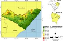
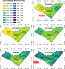
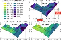
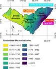
The lack of rainfall data in Alagoas, similar in many regions of the country, makes them use regression equations obtained in other regions of Brazil to calculate the R factor of the Universal Soil Loss Equation. The study aims to: i) define an equation to estimate rainfall erosivity based on the EI30 index and the rain coefficient Rc, ii) validate the data imputation method for rain and erosivity and iii) spatially estimate erosivity in rainy, dry and transition periods to Alagoas. Monthly rainfall data from 54 stations in the period (1960-2016) were used. The equation used showed a significant correlation between the observed and estimated data, according to the coefficients r (93%), R2 (87%) and RMSE (775.2 MJ.mm.ha−1.h−1). The Ordinary Kriging was the best spatial interpolator. The monthly isoerosivity showed that the highest EI30 rates occurred between April and July, a period coinciding with the rainy season in the state. In annual erosivity, the largest records are located in eastern Alagoas, close to the coast. Highlight for the stations Satuba, Maceió, São Luiz do Quitunde and Flexeiras, categorized between moderate and strong. These results will assist in planning conservation practices, especially in areas of vulnerability.
Keywords:
water erosion; spatial interpolation; soil loss
 Thumbnail
 Thumbnail
 Thumbnail
 Thumbnail
 Thumbnail
 Thumbnail
 Thumbnail


