
 Multitemporal Analysis of Land Use and Land Cover and the Heritage Vulnerability of Three Shellmounds in Guarapari, Espírito Santo State, Brazil (1984-2025)
Abstract
Landscape transformation in urban environments has increasingly exposed archaeological sites to heritage vulnerability. This study conducted a multitemporal analysis of land use and land cover in the municipality of Guarapari, Espírito Santo State, Brazil, and in the surroundings of three shellmounds (Concha D'Ostra, Una I, and Una II) between 1984 and 2025, aiming to assess their heritage vulnerability in response to landscape transformations. Supervised classification of LANDSAT satellite imagery was performed for the years 1984, 1995, and 2005 (LANDSAT 5), and 2015 and 2025 (LANDSAT 8), using geospatial analysis techniques in a Geographic Information System (GIS) environment (QGIS version 3.38.2-Grenoble, 2025). Five thematic classes were defined for image classification: Urban Area, Vegetation Area, Inland Water Body, Coastal Water Body, and Bare Land. Changes in land use and land cover were identified, and the extent of each thematic class was quantified throughout the study period. The results revealed substantial urban expansion, accompanied by reductions in vegetation cover and bare land, particularly in the surroundings of the shellmounds, where urban growth was most pronounced. Heritage vulnerability increased as a consequence of urban expansion and the growing conflicts between heritage preservation and tourism development. These findings demonstrate that geospatial technologies provide valuable support for territorial analysis and contribute to the development of public policies aimed at safeguarding archaeological heritage in areas under increasing anthropogenic pressure.
Keywords:
Geospatial Technologies; Archaeological Heritage; Urban Expansion
Resumo
A transformação da paisagem em ambientes urbanos tem deixado sítios arqueológicos em situação de vulnerabilidade. Este estudo fez uma análise multitemporal do uso e cobertura da terra no município de Guarapari, Espírito Santo, e no entorno de três sambaquis localizados no município (sambaquis Concha D’Ostra, Una I e Una II), no período de 1984 a 2025, para avaliar a vulnerabilidade dos sambaquis frente às transformações da paisagem. A pesquisa utilizou a classificação supervisionada de imagens de satélite LANDSAT, para os anos de 1984, 1995, 2005 (LANDAT 5) e 2015 e 2025 (LANDSAT 8), por meio de técnicas de geoprocessamento em ambiente SIG (QGIS versão 3.38.2-Grenoble, 2025). Foram definidas cinco classes temáticas para a classificação: Área Urbanizada; Área de Vegetação; Corpo D'água Continental; Corpo D'água Costeiro; Área Descoberta. Foram identificadas alterações e quantificadas as áreas das respectivas classes ao longo do período analisado. Os resultados demonstraram expansão das áreas urbanas, redução das áreas de vegetação e das áreas descobertas, com ênfase no entorno dos sambaquis, locais de expansão urbana. A vulnerabilidade dos sambaquis aumentou devido ao crescimento urbano e os conflitos entre preservação patrimonial e turismo. Conclui-se que as geotecnologias são ferramentas importantes para análise territorial e auxilio no planejamento de políticas públicas para conservação do patrimônio em áreas sob pressão antrópica.
Palavras-chave:
Geotecnologias; Patrimônio Arqueológico; Expansão Urbana
INTRODUCTION
The Brazilian coast has been inhabited since the pre-colonial period. Among the peoples who occupied this region were the sambaquieiros, the builders of sambaquis (shellmounds) - archaeological mounds composed of shells, bones, artifacts, and human burials (Alves; Gaspar, 2023). Distributed along the entire Brazilian coastline, these shellmounds constitute an invaluable source of information for understanding prehistoric coastal societies, making their preservation essential (Assumpção; Ritter, 2022; Cardoso et al., 2016).
According to Twardowsky et al. (2021), shellmound archaeological sites are of great importance not only because of their cultural significance but also because they preserve paleoenvironmental records that provide evidence of environmental changes over thousands of years.
The increasing urbanization of Brazil's coastal regions has resulted in profound socio-environmental transformations. This process has been driven primarily by urban expansion, which has increased the extent of built-up areas at the expense of natural landscapes, frequently occurring without adequate territorial planning (Vilarinho et al., 2023).
Anthropogenic pressure associated with urban expansion has increasingly exposed archaeological sites to conditions of heritage vulnerability (Cardoso et al., 2020). In this study, the vulnerability of shellmounds is understood as the susceptibility of these archaeological sites to the impacts arising from changes in land use and land cover in their surroundings, particularly those associated with urban expansion, vegetation loss, and the intensification of human activities (Santiago, 2015). From this perspective, vulnerability is not regarded solely as an intrinsic characteristic of archaeological heritage but rather as the result of interactions between environmental and anthropogenic factors that increase the potential for site degradation.
Studies conducted in Brazil have investigated shellmounds from different perspectives, including their archaeological characterization, chronology, conservation, and heritage management (Gaspar, 2000; Santiago, 2015). At the same time, research based on geospatial technologies has substantially advanced the understanding of land use and land cover dynamics in Brazilian coastal environments (Florenzano, 2011). Nevertheless, relatively few studies have integrated these approaches to investigate, from a multitemporal perspective, how landscape transformations influence the vulnerability of coastal archaeological sites.
Within this context, analyzing land use and land cover represents an important approach for understanding the spatiotemporal dynamics of these environments. Techniques based on remote sensing (RS) and Geographic Information Systems (GIS) enable the mapping of these areas across different spatial and temporal scales without causing direct impacts on archaeological sites. Furthermore, the free availability of satellite imagery from multiple sensors has facilitated studies aimed at monitoring and protecting cultural heritage. Because these methods are non-invasive, they have become increasingly important in archaeological research (Silva et al., 2024). Sodré et al. (2020) demonstrated the potential of these techniques for land use and land cover analysis. Likewise, a systematic review of 571 scientific publications showed that GIS has become a fundamental tool in archaeology, particularly for spatial visualization, information management, and spatial analysis (Menéndez-Marsh et al., 2023).
The originality of this study lies in integrating remote sensing, geospatial analysis, and the investigation of spatiotemporal land use and land cover dynamics to assess the heritage vulnerability of shellmounds located in a coastal area undergoing intense urban expansion. By analyzing a historical series of LANDSAT imagery spanning the period from 1984 to 2025, this study provides a long-term perspective on landscape transformation, enabling the identification of temporal trends and their potential implications for archaeological heritage.
The Concha D'Ostra, Una I, and Una II shellmounds, located in the municipality of Guarapari, Espírito Santo State, Brazil, exemplify how unplanned urban expansion can increase the vulnerability of this important cultural heritage. In this context, the present study analyzes the spatiotemporal dynamics of land use and land cover in the surroundings of these shellmounds between 1984 and 2025.
MATERIALS AND METHODS
The first stage of the study consisted of a literature review to establish the theoretical framework and identify knowledge gaps related to the research topic. Fieldwork was subsequently conducted to determine the location of the shellmounds using a Global Positioning System (GPS) receiver, allowing the geographic coordinates of the three archaeological sites to be recorded.
Satellite image acquisition and selection
For the multitemporal analysis, images from the LANDSAT 5 TM and LANDSAT 8 OLI satellites were selected. The LANDSAT program provides a continuous historical archive of satellite imagery suitable for multitemporal studies, enabling the detection of landscape changes over several decades (Nogueira; Parente, 2017). The selected images have a spatial resolution of 30 m, which is appropriate for the objectives of this study.
Satellite images were acquired for the following dates: July 19, 1984, June 7, 1995, and July 4, 2005 (LANDSAT 5), and August 1, 2015, and September 29, 2025 (LANDSAT 8). Images from different satellite missions were used because LANDSAT 5 was decommissioned in January 2013. Minor differences in acquisition dates reflect data availability and atmospheric conditions affecting image quality.
The year 1984 was selected as the starting point of the historical series because earlier LANDSAT imagery has a coarser spatial resolution, limiting the discrimination of land use and land cover classes required for this study.
Image selection followed three criteria: (i) complete spatial coverage of the municipality of Guarapari; (ii) cloud cover not exceeding 20%; and (iii) adequate image quality for land use and land cover classification. These criteria improve image interpretation while minimizing cloud-shadow effects during the classification process (Cho et al., 2021).
Image processing was carried out using QGIS version 3.38.2-Grenoble (QGIS, 2025), an open-source Geographic Information System (GIS). Both the software and the satellite imagery are freely available, promoting methodological transparency, reproducibility, and wider accessibility of geospatial technologies (Souza Júnior et al., 2022). All spatial analyses were performed using the SIRGAS 2000 / UTM Zone 23S coordinate system (EPSG:31983).
Image processing and classification
Image preprocessing consisted of generating false-color composites using spectral bands that maximize the discrimination of land use and land cover classes. For LANDSAT 5, the composite included Band 1 (Red), Band 2 (Green), and Band 3 (Blue), whereas for LANDSAT 8, Band 4 (Red), Band 3 (Green), and Band 2 (Blue) were used. Subsequently, the municipal boundary of Guarapari was applied to clip the imagery, reducing data volume and optimizing computational processing by excluding areas outside the study area.
After preprocessing, a supervised image classification was performed. This procedure requires the selection of representative training samples for each thematic class. Five land use and land cover classes were defined according to the IBGE Technical Manual of Land Use (IBGE, 2013): Urban Area, Vegetation Area, Inland Water Body, Coastal Water Body, and Bare Land, the latter including exposed soil, beach sand, degraded areas, and rocky outcrops. These classes adequately represent the landscape characteristics relevant to the objectives of this research.
Image classification was performed using the dzetsaka plugin in QGIS, applying the Random Forest algorithm. This machine-learning classifier has been widely recognized for its robustness and high performance in land use and land cover mapping (Ferla; Kuplich, 2025). Random Forest constructs multiple decision trees from randomly selected subsets of training data and predictor variables, producing the final classification through majority voting among individual trees (Andrade et al., 2023).
The consistency of the classification was assessed through iterative visual inspection of the classified maps, evaluating the correspondence between the mapped classes and the spectral patterns observed in the satellite imagery. At least 30 training samples were collected for each thematic class. Training samples were selected through visual interpretation of LANDSAT images, considering classical photointerpretation elements, including tone, texture, shape, pattern, spatial context, and association with neighboring features (Lillesand et al., 2015). Homogeneous and representative areas were prioritized to minimize mixed pixels and ensure sufficient spectral variability for training the supervised classification algorithm. Sample collection covered the entire study area to adequately represent the spatial distribution of all land use and land cover classes.
Quantitative accuracy assessment based on a confusion matrix, Kappa coefficient, or equivalent metrics was not performed. Instead, classification consistency was evaluated through visual interpretation of the classified maps and verification of the spatial coherence between thematic classes, observable landscape features in the LANDSAT imagery, and prior knowledge of the study area. This procedure enabled the identification of classification inconsistencies and the refinement of training samples throughout the mapping process. Nevertheless, the absence of quantitative accuracy metrics is recognized as a methodological limitation of this study. Therefore, the resulting maps should be interpreted as representations of general landscape transformation trends rather than highly precise cartographic products.
For analyses of the areas surrounding the shellmounds, a mapping scale of 1:25,000 was adopted to provide greater spatial detail and improve mapping precision (Ming et al., 2011). This scale is compatible with the spatial resolution of LANDSAT imagery. According to Congalton and Green (2009) and Jensen (2015), medium-resolution sensors are appropriate for land use and land cover mapping at intermediate scales, allowing the consistent representation of spatial patterns and thematic classes without compromising cartographic reliability. In the Brazilian context, Florenzano (2011) also emphasizes that LANDSAT imagery is widely used for environmental and territorial studies at mapping scales ranging from 1:25,000 to 1:50,000, provided that the limitations imposed by sensor spatial resolution are properly considered.
RESULTS AND DISCUSSION
Urbanization Process in the Municipality
The analysis of the classified images reveals a marked intensification of urbanization in the municipality of Guarapari between 1984 and 2025. This trend is consistent with the demographic growth recorded over recent decades, with the population increasing from 47,848 inhabitants in 1985 to 134,944 in 2024, representing a 182% increase (IBGE, 2025). This growth rate exceeds those observed for both the state of Espírito Santo (70%) and Brazil (57%) over the same period (IBGE, 2025), highlighting the intense territorial occupation dynamics of the municipality.
Guarapari's population growth is closely associated with its consolidation as one of the leading tourist destinations on the Brazilian coast. During the peak tourist season, the municipality receives approximately 700,000 visitors (SECULT, 2025). This seasonal population increase intensifies the demand for urban infrastructure, public services, and real estate development. In coastal municipalities, tourism acts as a major driver of territorial transformation, promoting changes in land use and land cover, urban expansion, and the increasing occupation of environmentally sensitive areas (Castro et al., 2025; Pierri Daunt; Silva, 2019).
These transformations reflect broader processes of spatial production and restructuring, in which different social actors - including the State, the real estate sector, and local communities - contribute to redefining land use patterns (Santos, 2008). In Guarapari, urban expansion has been facilitated by improvements in transportation infrastructure, interventions along the coastal waterfront, and weaknesses in the implementation of territorial planning instruments (Rocha, 2019). These factors have encouraged the occupation of areas near beaches and around the shellmounds. Consequently, increasing pressure has been exerted on areas of high environmental and cultural value, resulting in greater heritage vulnerability driven by the intensification of anthropogenic activities.
Similar processes have been documented in other Brazilian coastal cities, where urbanization has substantially altered landscape configuration through the replacement of natural environments with anthropogenic surfaces, increased soil sealing, and vegetation fragmentation (Castro et al., 2025; Pierri Daunt; Silva, 2019). These transformations reduce landscape connectivity and intensify conflicts between urban expansion, environmental conservation, and cultural heritage preservation, highlighting the need to integrate territorial planning with heritage and environmental protection policies.
In this context, geospatial technologies, particularly remote sensing and Geographic Information Systems (GIS), provide valuable tools for monitoring landscape transformations across multiple temporal scales. The supervised classification of LANDSAT imagery enabled the identification and quantification of land use and land cover changes, allowing the assessment of the spatiotemporal evolution of the thematic classes between 1984 and 2025 and supporting the analysis of the territorial pressures exerted on the shellmounds (Tables 1, 2, 3).
Spatiotemporal Dynamics of Land Use and Land Cover in the Municipality of Guarapari
The multitemporal analysis of land use and land cover highlights the changes in the landscape of the municipality of Guarapari during the period (Table 1). The changes observed reflect the intensification of urbanization and territorial restructuring processes characteristic of Brazilian coastal cities, marked by the expansion of urban infrastructure, rising real estate values, and increasing pressure on natural areas and sites of heritage interest (IBGE, 2013).
The Urban Area category showed the greatest change, recording a 745.79% increase (Table 2), corresponding to the addition of approximately 90.2 km2 to the urban area. Although growth was modest between 1984 and 1995, it accelerated beginning in 1995, a period during which urban expansion began to occur in multiple directions and with greater intensity.
This trend is linked to Guarapari’s emergence as a major tourist destination on the Espírito Santo coast and to the recorded population growth - factors that have increased the demand for urban infrastructure, housing, and services. According to Santos (2008), urban expansion results from the coordinated actions of various agents that shape the built environment, whose interaction drives continuous transformations in territorial organization. The results obtained are consistent with studies conducted in other Brazilian coastal regions, which identified urbanization as the main driver of landscape transformation (Moura et al., 2015;Pinho; Carriço, 2021).
For the Vegetation Area class, relative stability was observed throughout the time series, with a net increase of only 0.62% between 1984 and 2025 (Table 2). Despite the decline observed between 1995 and 2005, the data indicate a partial recovery of vegetation cover in the following decades. This pattern suggests that, although urban expansion has led to the conversion of certain natural areas, some of the vegetation has regenerated, possibly as a result of ecological succession in previously degraded areas and the protection provided by the conservation areas established in the municipality.
The Bare Land class showed the largest reduction, with a decrease of 97.25%, equivalent to a loss of approximately 126.67 km2. The significant decline in this category reflects the incorporation of these areas into the urbanization process. As a result, the uncovered areas are now concentrated on the beaches and in small exposed areas. From the perspective of territorial dynamics, the gradual replacement of open areas with urbanized areas represents a significant change in the landscape’s configuration. Soil sealing alters hydrological processes, reduces water infiltration, increases surface runoff, and disrupts the environmental balance of coastal areas, in addition to increasing pressure on environments of high ecological and archaeological sensitivity (Tucci, 2008).
The Inland Water Body and Coastal Water Body categories showed fluctuations throughout the historical time series. However, these variations are not the main focus of this research and did not have a significant impact on the asset vulnerability analyses conducted in this study.
Taken together, the results show that the main transformation that has taken place in Guarapari over the past four decades has been the intensification of urbanization, a process that has reshaped the municipal landscape and altered the relationships between natural and human-made areas. These changes are an important indicator of the pressures exerted on the shellmounds studied. In this context, multitemporal analysis of land use and land cover emerges as a fundamental tool for understanding the processes that influence heritage vulnerability in coastal environments.
Although the changes identified represent trends observed at the municipal level, their spatial distribution was not uniform. In areas surrounding the shellmounds, urban expansion has taken on distinctive characteristics, intensifying land-use pressures on the archaeological sites. For this reason, the following subsections provide a detailed analysis of land use and land cover patterns in the areas surrounding the Concha D'Ostra, Una I, and Una II shellmounds.
Spatiotemporal Dynamics of Land Use and Land Cover in the Surroundings of the Shellmounds
A multitemporal analysis of land use and land cover in the areas surrounding the shellmounds shows that the changes observed at the municipal level also occurred in the areas surrounding the archaeological sites (Tables 3 and 5). However, urban expansion did not occur uniformly throughout the Guarapari area. She focused on areas subject to real estate development, infrastructure expansion, and tourism-related development. As a result, the shellmounds have come to be situated within a more human-altered landscape, increasing their exposure to pressures resulting from human activities.
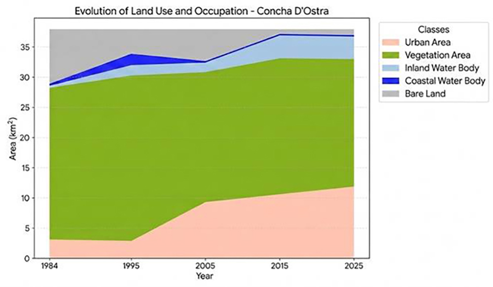
In the area surrounding the Concha D'Ostra shellmound, the Urban Area category showed a 283.20% increase (Table 4), corresponding to an expansion of 8.79 km2 in the urban fabric. The results show a continuous process of urban expansion toward the archaeological site, particularly beginning in the second half of the 1990s. This trend is consistent with the pattern observed for the municipality as a whole, indicating that urban growth has begun to encroach on areas previously covered by vegetation and open spaces.
In coastal areas, this process tends to be intensified by the development of the coastal zone and the expansion of tourism activities, leading to significant changes in the landscape and exacerbating conflicts between urban development, environmental conservation, and the preservation of cultural heritage (Moraes, 2007).
The urban expansion observed in the area surrounding Concha D'Ostra has implications that go beyond the simple replacement of one land-use category with another. The gradual development of the surrounding area alters the landscape context in which the archaeological site is located, reducing its environmental integrity and increasing its susceptibility to impacts resulting from human activity, such as road construction, construction of buildings, earthmoving, waste disposal, human traffic, and unplanned interventions. As discussed by Funari (2006) and Smith (2006), urbanization is one of the main threats to archaeological heritage, especially when it occurs at a rapid pace and is not accompanied by effective tools for land-use planning and cultural preservation.
The Vegetation Area class showed a 3.13% decrease over the period, corresponding to a loss of 0.78 km2. Although the reduction is modest when compared to the other classes, its significance can be analyzed from the perspective of landscape ecology. The removal of vegetation in coastal environments not only leads to a decrease in vegetation cover but also to increased fragmentation of the remaining vegetation, reduced ecological connectivity, and intensified edge effects - processes that compromise ecosystem functioning and reduce their capacity for natural protection (Forman, 1995; Metzger, 2001).
In the specific case of shellmounds, vegetation cover plays a significant role in the physical stability of the environment, helping to control erosion, stabilize sediments, and preserve the geomorphological characteristics associated with archaeological deposits (Twardowsky et al., 2021). Even small reductions in vegetation can increase the vulnerability of cultural heritage sites, as they leave the sites more exposed to the effects of climatic factors and human activities.
The Bare Land category showed an 89.40% decrease between 1984 and 2025, equivalent to a loss of 8.09 km2. The results indicate that a large portion of these areas has been absorbed by urban expansion, particularly as a result of the growth of the Coroado and Santa Margarida neighborhoods. This conversion highlights the gradual replacement of natural areas by permanent urban land uses, a process observed in Brazilian coastal municipalities undergoing real estate development and population growth (Mello et al., 2013; Silva; Ferreira, 2019).
From the perspective of cultural heritage vulnerability, this transformation demonstrates that urban pressure is no longer confined to the immediate vicinity of the shellmound but has become an integral part of the broader territorial context in which the site is located. Thus, the vulnerability identified in this study does not stem exclusively from the physical proximity between urban development and archaeological heritage, but rather from the ongoing alteration of the landscape, which gradually reduces the natural elements responsible for its protection and increases the site’s exposure to anthropogenic pressures.
The variations observed in the Inland Water Body and Coastal Water Body classes were considered secondary to the objectives of this study, since they did not have a significant influence on the analysis of territorial dynamics and heritage vulnerability.
In summary, the dynamics observed in the vicinity of the Concha D'Ostra shellmound reveal an ongoing process of human impact on the landscape, characterized by the expansion of urbanization, a reduction in open areas, and the relative preservation of vegetation cover. Although the changes in vegetation were less pronounced than those observed in the vicinity of the Una I and Una II shellmounds (Tables 5 and 6), the intensification of urban development indicates that the archaeological site is now situated within a territorial context of increasing anthropogenic pressure. These findings reinforce the idea that heritage vulnerability should be understood as a dynamic condition, shaped by the interaction between landscape transformations, urbanization processes, and the capacity to protect archaeological sites.
The Urban Area category grew by 1,141.29% between 1984 and 2025 (Table 6), corresponding to an increase of approximately 20.77 km2. As noted for the municipality and the area surrounding Concha D'Ostra, urban expansion occurred at a modest pace between 1984 and 1995, but accelerated beginning in the second half of the 1990s. However, unlike Concha D'Ostra - where urbanization has grown significantly while vegetation cover has remained relatively stable - the areas surrounding the Una I and Una II shellmounds have seen the simultaneous replacement of natural areas and cleared areas with urban land uses. This reflects the intensification of urban development processes in the municipality’s outlying areas, driven by infrastructure expansion, rising real estate values, and growing demand for housing and services associated with urban development and tourism.
The reduction in Vegetation Area amounted to 33.75% of the vegetation cover, corresponding to 6.37 km2. This pattern contrasts with the relative stability observed at the municipal level and with the slight reduction recorded in the vicinity of Concha D'Ostra, indicating that the pressure exerted on the Una I and Una II shellmounds was more intense and localized.
The Bare Land class showed a 94.73% reduction, equivalent to a loss of 14.45 km2. As observed in the area surrounding Concha D'Ostra, most of these areas have been incorporated into the urbanization process. However, in the case of the Una I and Una II shellmounds, this conversion occurred simultaneously with the reduction in vegetation, indicating a more comprehensive process of landscape transformation, characterized by the replacement of different types of natural cover with urbanized areas.
This combination of rapid urban growth, a significant reduction in vegetation, and the near-total elimination of open areas points to a scenario of greater anthropogenic pressure compared to the area surrounding Concha D'Ostra. While the latter still retains part of its original landscape structure, the Una I and Una II shellmounds are located within a heavily urbanized area, where the remaining natural habitats are becoming increasingly fragmented and isolated.
From the perspective of heritage vulnerability, the results show that the Una I and Una II shellmounds are more susceptible to the impacts of urban expansion. As discussed by Funari (2006), Smith (2006), and Gaspar (2000), urbanization is one of the main factors contributing to the degradation of archaeological heritage, as it encourages direct interventions at sites, alters their landscape context, and intensifies indirect processes such as soil disturbance, soil sealing, waste disposal, human traffic, and real estate development pressure. In this regard, the vulnerability identified in this study stems not only from the physical proximity between archaeological sites and the urban fabric, but also from the intensity of the territorial transformations that have accumulated over the period analyzed (Chart 1).
Although the Inland Water Body and Coastal Water Body classes exhibited temporal fluctuations, these changes were considered secondary to the objectives of this study because they did not significantly affect the interpretation of territorial dynamics or heritage vulnerability.
A comparison of the two areas analyzed shows that the heritage vulnerability of the shellmounds is not uniform across the Guarapari region (Figure 2, Figure 3, Figure 4). Although both are subject to pressures resulting from urban expansion, the areas surrounding the Una I and Una II shellmounds show more intense changes in the landscape structure, characterized by greater urbanization and a more significant loss of vegetation cover. These results show that land-use and land-cover dynamics are an important indicator for inferring different levels of cultural heritage vulnerability, providing a basis for establishing priorities for monitoring, conservation, and land-use planning aimed at protecting archaeological sites.

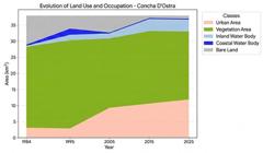
Land use and land cover dynamics in the surroundings of the Concha D'Ostra shellmound (1984-2025)

Land use and land cover dynamics in the surroundings of the Una I and Una II shellmounds (1984-2025)
Heritage Vulnerability and Land-Use Conflicts
The results indicate that the heritage vulnerability of the shell mounds is not determined solely by landscape transformations, but also by the limitations of territorial management instruments in addressing the intensity of urban expansion. Although the Una I and Una II shell mounds are located within the Setiba Environmental Protection Area and the Concha D'Ostra shell mound lies within the Concha D'Ostra Sustainable Development Reserve, the existence of these protected areas has not been sufficient to ensure the effective preservation of the archaeological sites. The persistence and intensification of anthropogenic pressures observed throughout the analyzed time series demonstrate that legal protection does not necessarily translate into effective heritage conservation, particularly in areas experiencing rapid urban expansion and real estate development.
For analytical purposes, heritage vulnerability was inferred from the relationship between the main landscape transformations identified and the territorial processes associated with urban expansion. Chart 1 summarizes the indicators adopted in the interpretation of the results, demonstrating how the observed land-use and land-cover changes were associated with increasing anthropogenic pressures on the shell mounds.
Within the framework of municipal land-use planning, the Guarapari Master Plan (Guarapari, 2016) recognizes the shell mounds as Cultural Preservation Areas (APC-3), classifying them as non aedificandi areas where new construction is prohibited. However, the same planning instrument also designates zones intended for tourism development, thereby encouraging real estate expansion in strategic sectors. This coexistence of preservation guidelines and policies promoting economic development highlights the conflicts inherent to the management of Brazilian coastal zones, where tourism, urban growth, and land valorization frequently take precedence over cultural heritage conservation strategies (Moraes, 2007; Castro et al., 2025).
Similar situations have been documented elsewhere in Brazil. Barros (2016), in an analysis of the impacts of the Manaus Free Trade Zone on archaeological heritage, demonstrated that the existence of legal protection mechanisms did not prevent the destruction of archaeological sites in the face of urban expansion and large-scale development projects. These findings reinforce that heritage vulnerability is closely related to the capacity to integrate heritage preservation, territorial planning, and enforcement policies, rather than merely to the formal existence of legal protection mechanisms.
In this context, the results of this study indicate that the expansion of urbanized areas constitutes an important indicator of the territorial pressures exerted on the shell mounds. Urban growth intensifies infrastructure development, increases human circulation, stimulates land valorization, and raises the likelihood of both direct and indirect interventions affecting archaeological sites. At the same time, the reduction of vegetation cover diminishes the landscape's natural protective functions, favoring erosion, geomorphological changes, and other degradation processes that compromise both the physical integrity and the archaeological context of the shell mounds.
Given this scenario, strengthening coordination among municipal, state, and federal agencies responsible for territorial planning, environmental management, and cultural heritage protection is essential to incorporate shell mounds into the management plans of existing protected areas and broader land-use planning policies. Heritage education initiatives targeting local communities (Coutinho et al., 2023), together with scientific and cultural tourism programs (Silva, 2025), can contribute to increasing public awareness of these archaeological sites and strengthening preventive conservation strategies.
The heritage vulnerability identified in this study should therefore be understood as the outcome of the interaction between landscape dynamics, urbanization processes, and the effectiveness of territorial management instruments. The multitemporal land-use and land-cover analysis demonstrated that the transformations occurring over the past four decades have substantially altered the environmental and territorial context surrounding the shell mounds, particularly Una I and Una II, highlighting that the conservation of archaeological heritage depends not only on legal protection but also on integrated planning policies, continuous monitoring, and collaborative territorial management.
CONCLUSION
This study demonstrated that multitemporal land-use and land-cover analysis, supported by geospatial technologies, is an effective approach for understanding territorial dynamics surrounding archaeological sites and inferring their heritage vulnerability. The integration of remote sensing, GIS-based geoprocessing, and landscape analysis made it possible to identify how landscape transformations over the past four decades have altered the territorial context of the shell mounds in Guarapari, revealing that urban expansion is the primary driver of pressure on these cultural heritage sites.
The findings indicate that heritage vulnerability should be understood as a dynamic process, resulting from the interaction between urban expansion, vegetation loss, and landscape reconfiguration, rather than as an intrinsic characteristic of archaeological sites. In this sense, the study strengthens the dialogue between Geography, Archaeology, and Territorial Planning by proposing an integrated approach for assessing the effects of land-use and land-cover changes on archaeological heritage. Beyond its scientific contribution, the proposed methodology provides valuable support for long-term monitoring, the identification of priority areas for conservation, and the development of public policies aimed at territorial management and cultural heritage protection.
This study has some limitations. Heritage vulnerability was inferred from spatial indicators derived from land-use and land-cover dynamics and did not incorporate variables related to the physical conservation status of the shell mounds, the intensity of on-site anthropogenic disturbances, or socioeconomic factors that may also influence degradation processes. Furthermore, the spatial resolution of the LANDSAT imagery should be considered when interpreting the results, particularly for analyses conducted at the local scale.
Future research should integrate higher-resolution satellite imagery, field surveys, socio-environmental indicators, and advanced remote sensing techniques to improve analytical accuracy and support the development of quantitative heritage vulnerability indices. Applying this methodological framework to other Brazilian coastal municipalities may also contribute to comparative analyses and to the improvement of territorial planning strategies and preventive archaeological heritage conservation.
DATA AVAILABILITY
The data that underpin the results of this study may be made available by the corresponding author, upon duly justified request. [Rafael Said Bhering Cardoso].
References
- ALVES, A. B.; GASPAR, M. D. B. A arqueologia imperial e as indústrias líticas de sambaquieiros nos discursos evolucionistas culturais (1820-1880). Cadernos do LEPAARQ, Pelotas, v. 20, n. 39, p. 39-68, 2023. Doi: 10.15210/lepaarq.v20i39.4833
- ANDRADE, O. B.; MONTENEGRO, A. A. A.; SOUSA, L. B.; SILVA NETO, M. A.; CHAGAS, A. M. S.; ALMEIDA, T. A. B. Classificação do uso e ocupação do solo utilizando imagens de satélite e drone: comparação de técnicas de aprendizado de máquina. In: SIMPÓSIO BRASILEIRO DE RECURSOS HÍDRICOS, 25., 2023, Aracaju. Anais [...]. Aracaju: Associação Brasileira de Recursos Hídricos, 2023.
-
ASSUMPÇÃO, C.; RITTER, M. C. Pesquisadores do passado: a importância da preservação dos sambaquis. Campo Grande News, Campo Grande, 23 ago. 2022. Disponível em: Disponível em: https://www.campograndenews.com.br/artigos/pesquisadores-do-passado-a-importancia-da-preservacao-dos-sambaquis Acesso em: 14 ago. 2025.
» https://www.campograndenews.com.br/artigos/pesquisadores-do-passado-a-importancia-da-preservacao-dos-sambaquis - BARROS, E. C. C. Diagnóstico da destruição: os efeitos da expansão urbana sobre os sítios arqueológicos de Manaus/AM. 2016. 151 f. Dissertação (Mestrado Profissional em Preservação do Patrimônio Cultural) - Instituto do Patrimônio Histórico e Artístico Nacional, Rio de Janeiro, 2016
- CARDOSO, R. S. B. Transformação da paisagem: os sambaquis e a relação com o patrimônio arqueológico no município de Guarapari-ES no período 1984-2011. 2016. 100 f. Dissertação (Mestrado em Patrimônio Cultural, Paisagens e Cidadania) - Universidade Federal de Viçosa, Viçosa, 2016.
-
CARDOSO, R. S. B.; FARIA, A. L. L.; ROCHA, P. A.; TEIXEIRA, R. C.; COSTA, L. M.; ASSIS, A. A. F. Sambaquis from the coast of Guarapari, Espírito Santo, Brazil: chemistry, physics and malacofauna. Sociedade & Natureza, Uberlândia, v. 32, p. 728-739, 2020. Doi: 10.14393/SN-v32-2020-54869
» https://doi.org/10.14393/SN-v32-2020-54869 -
CASTRO, V. K.; MANHÃES, A. J. P.; TEIXEIRA, K. B.; SALES, D. S.; ALMADA, E. V. C.; CORREIA, V. G.; SALES, C. M. R.; PINTO, A. E. M. Impacts of tourism on coral reefs along the Brazilian coast: key factors and solutions. Revista de Gestão Social e Ambiental, v. 19, n. 2, p. 1-15, 2025. Doi: 10.24857/rgsa.v19n2-109
» https://doi.org/10.24857/rgsa.v19n2-109 -
CHO, D. F.; SCHWAIDA, S. F.; CICERELLI, R. E.; ALMEIDA, T.; RAMOS, A. P. M.; SANO, E. E. Desempenho do algoritmo de classificação de imagens Random Forest para mapeamento do uso e cobertura do solo no Cerrado brasileiro. Anuário do Instituto de Geociências, Rio de Janeiro, v. 44, e37979, 2021. Doi: 10.11137/1982-3908_2021_44_37979
» https://doi.org/10.11137/1982-3908_2021_44_37979 -
CONGALTON, R. G.; GREEN, K. Assessing the accuracy of remotely sensed data: principles and practices. 2. ed. Boca Raton: CRC Press, 2009. Doi: 10.1201/9781420055139
» https://doi.org/10.1201/9781420055139 - COUTINHO, H. R. N.; SILVA, A. S. N. F.; SOUZA, L. C.; ROCHA, L. C. M. Reflexões sobre arqueologia pública, educação patrimonial e o "saber de experiência" no ato de educar para o patrimônio. FUMDHAMentos, v. 20, n. 2, p. 43-60, 2023.
-
FERLA, A. K.; KUPLICH, T. M. Utilização do classificador Random Forest para classificação do uso e cobertura da terra a partir de dados Sentinel-1 e Sentinel-2 em região campestre no bioma Mata Atlântica. Geografia Ensino & Pesquisa, Santa Maria, v. 29, e87967, 2025. Doi: 10.5902/2236499487967
» https://doi.org/10.5902/2236499487967 - FLORENZANO, T. G. Iniciação em sensoriamento remoto. 3. ed. São Paulo: Oficina de Textos, 2011.
-
FORMAN, R. T. T. Land mosaics: the ecology of landscapes and regions. Cambridge: Cambridge University Press, 1995. Doi: 10.1017/9781107050327
» https://doi.org/10.1017/9781107050327 - FUNARI, P. P. A. Arqueologia. São Paulo: Contexto, 2006.
- GASPAR, M. D. Sambaqui: arqueologia do litoral brasileiro. Revista USP, São Paulo, n. 44, p. 244-251, 2000.
- GUARAPARI (ES). Lei Complementar n.º 90, de 11 de novembro de 2016. Dispõe sobre a política de desenvolvimento e ordenamento territorial, institui o Plano Diretor do Município de Guarapari e dá outras providências. Diário Oficial do Município de Guarapari, Guarapari, ES, 11 nov. 2016.
- INSTITUTO BRASILEIRO DE GEOGRAFIA E ESTATÍSTICA (IBGE). Manual técnico de uso da terra. 3. ed. Rio de Janeiro: IBGE, 2013.
-
INSTITUTO BRASILEIRO DE GEOGRAFIA E ESTATÍSTICA (IBGE). Cidades e Estados: Guarapari. Rio de Janeiro: IBGE , 2025. Disponível em: Disponível em: https://cidades.ibge.gov.br /. Acesso em: 25 ago. 2025.
» https://cidades.ibge.gov.br -
INSTITUTO BRASILEIRO DE GEOGRAFIA E ESTATÍSTICA (IBGE). IBGE Cidades: Guarapari. 2025. Disponível em: Disponível em: https://cidades.ibge.gov.br/brasil/es/guarapari/panorama Acesso em: 12 ago. 2025.
» https://cidades.ibge.gov.br/brasil/es/guarapari/panorama - JENSEN, J. R. Introductory digital image processing: a remote sensing perspective. 4. ed. Upper Saddle River: Pearson, 2015.
-
LANDSAT 8. OLI/TIRS Scene LC08_L1TP_216074_20250929. Sioux Falls: USGS, 2023. 1 imagem de satélite. Disponível em: Disponível em: https://www.usgs.gov/landsat-missions/landsat-8 Acesso em: 15 mar. 2026.
» https://www.usgs.gov/landsat-missions/landsat-8 - LILLESAND, T. M.; KIEFER, R. W.; CHIPMAN, J. W. Remote sensing and image interpretation. 7. ed. Hoboken: Wiley, 2015.
-
MELLO, K.; TOPPA, R. H.; ABESSA, D. M. S. Dinâmica da expansão urbana na zona costeira brasileira: o caso do município de São Vicente, São Paulo, Brasil. Revista de Gestão Costeira Integrada, Lisboa, v. 13, n. 4, p. 527-539, 2013. Doi: 10.5894/rgci432
» https://doi.org/10.5894/rgci432 -
MENÉNDEZ-MARSH, F.; AL-RAWI, M.; FONTE, J.; DIAS, R.; GONÇALVES, L. J.; SECO, L. G.; HIPÓLITO, J.; MACHADO, J. P.; MEDINA, J.; MOREIRA, J.; PEREIRO, T.; VÁZQUEZ, M.; NEVES, A. Geographic information systems in archaeology: a systematic review. Journal of Computer Applications in Archaeology, v. 6, n. 1, p. 40-50, 2023. Doi: 10.5334/jcaa.104
» https://doi.org/10.5334/jcaa.104 -
METZGER, J. P. O que é ecologia de paisagens? Biota Neotropica, Campinas, v. 1, n. 1-2, p. 1-9, 2001 Doi: 10.1590/S1676-06032001000100006
» https://doi.org/10.1590/S1676-06032001000100006 -
MING, D.; YANG, J.; LI, L.; SONG, Z. Modified ALV for selecting the optimal spatial resolution and its scale effect on image classification accuracy. Mathematical and Computer Modelling, v. 54, n. 3-4, p. 1061-1068, 2011. Doi: 10.1016/j.mcm.2010.11.036
» https://doi.org/10.1016/j.mcm.2010.11.036 - MORAES, A. C. R. Contribuições para a gestão da zona costeira do Brasil: elementos para uma geografia do litoral brasileiro. São Paulo: Annablume, 2007.
-
MOURA, N. S. V.; MORAN, E. F.; STROHAECKER, T. M.; KUNST, A. V. A urbanização na zona costeira: processos locais e regionais e as transformações ambientais - o caso do litoral norte do Estado do Rio Grande do Sul, Brasil. Ciência e Natura, Santa Maria, v. 37, p. 226-237, 2015. Doi: 10.5902/2179460X18503
» https://doi.org/10.5902/2179460X18503 - NOGUEIRA, S. H. M.; PARENTE, L. L. Temporal Visual Inspection: uma ferramenta destinada à inspeção visual de pontos em séries históricas de imagens de sensoriamento remoto. In: SIMPÓSIO BRASILEIRO DE SENSORIAMENTO REMOTO, 18., 2017, Santos. Anais [...]. São José dos Campos: Instituto Nacional de Pesquisas Espaciais, 2017.
-
PIERRI DAUNT, A. B.; SILVA, T. S. F. Beyond the park and city dichotomy: land use and land cover change in the northern coast of São Paulo (Brazil). Landscape and Urban Planning, v. 189, p. 352-361, 2019. Doi: 10.1016/j.landurbplan.2019.05.003
» https://doi.org/10.1016/j.landurbplan.2019.05.003 - PINHO, R. M. L.; CARRIÇO, J. M. A urbanização na zona costeira e os impactos ambientais: o caso da RMBS no estado de São Paulo. Leopoldianum, Santos, ano 47, n. 131, p. 22-38, 2021.
-
QGIS DEVELOPMENT TEAM. QGIS Geographic Information System. Versão 3.38.2-Grenoble. [S. l.]: Open Source Geospatial Foundation, 2025. Disponível em: Disponível em: https://qgis.org Acesso em: 05 set. 2025.
» https://qgis.org - ROCHA, R. C. Verticalização litorânea do Centro de Guarapari: um estudo de caso em geografia urbana. 2019. Dissertação (Mestrado em Geografia) - Programa de Pós-Graduação em Geografia, Universidade Federal do Espírito Santo, Vitória, 2019.
-
SANTIAGO, D. G. A proteção do patrimônio arqueológico: motivações, critérios e diretrizes no tombamento de sítios arqueológicos pelo IPHAN. 2015. Dissertação (Mestrado Profissional em Preservação do Patrimônio Cultural) - Instituto do Patrimônio Histórico e Artístico Nacional, Rio de Janeiro, 2015. Doi: 10.24885/sab.v29i1.451
» https://doi.org/10.24885/sab.v29i1.451 - SANTOS, M. A natureza do espaço: técnica e tempo, razão e emoção. 4. ed. São Paulo: EdUSP, 2008.
- SECULT - Secretaria de Estado da Cultura do Espírito Santo. Dados turísticos sazonais de Guarapari: 2024-2025. Vitória: SECULT, 2025.
-
SILVA, L. A. A conexão possível: a gestão do patrimônio arqueológico em unidades de conservação. Cadernos do LEPAARQ , Pelotas, v. 22, n. 43, p. 13-36, 2025. Doi: 10.15210/lepaarq.v22i43.28488
» https://doi.org/10.15210/lepaarq.v22i43.28488 -
SILVA, R. A.; SILVA, G. D.; XAVIER, M. C. T.; SANTANA, J. A. C.; SANTANA, C. C. S. Mapeamento de sítios arqueológicos cerâmicos: contribuição para a gestão socioambiental. Revista Políticas Públicas & Cidades, v. 13, n. 2, e1077, 2024. Doi: 10.23900/2359-1552v13n2-320-2024
» https://doi.org/10.23900/2359-1552v13n2-320-2024 -
SILVA, T. C. L.; FERREIRA, B. Transformações multi-temporais do uso e coberturas das terras no bairro de Cruz das Almas, litoral norte de Maceió, Alagoas, Nordeste do Brasil. Revista Brasileira de Geografia Física, Recife, v. 12, n. 1, p. 310-325, 2019. Doi: 10.26848/rbgf.v12.1.p310-325
» https://doi.org/10.26848/rbgf.v12.1.p310-325 -
SMITH, L. Uses of heritage. London: Routledge, 2006. Doi: 10.4324/9780203602263
» https://doi.org/10.4324/9780203602263 -
SODRÉ, B. F. A.; CARELLI, L.; SANTOS, R. L.; SANTO, S. M. As geotecnologias como suporte para análise do uso e ocupação do solo urbano: um estudo em Feira de Santana (Bahia - Brasil). Brazilian Journal of Development, Curitiba, v. 6, n. 12, p. 101144-101161, 2020. Doi: 10.34117/bjdv6n12-563
» https://doi.org/10.34117/bjdv6n12-563 -
SOUZA JÚNIOR, T. G.; LIMA, M. T. V.; PALÁCIO, O. D.; OLIVEIRA, C. W. A importância do geoprocessamento na opinião de pessoas apresentadas a um software SIG livre, através de minicursos. Revista Práxis: Saberes da Extensão, João Pessoa, v. 10, n. 20, p. 107-122, 2022. Doi: 10.18265/2318-23692022v10n20p107-122
» https://doi.org/10.18265/2318-23692022v10n20p107-122 - TUCCI, C. E. M. Gestão integrada das águas urbanas. REGA: Revista de Gestão de Água da América Latina, Porto Alegre, v. 5, n. 2, p. 71-81, 2008.
-
TWARDOWSKY, A. C.; BANDEIRA, D. R.; GUEDES, S. P. L. C. Um olhar para o estado de conservação dos sambaquis urbanos de Joinville. Escritas: Revista do Curso de História de Araguaína, Araguaína, v. 13, n. 2, p. 137-155, 2021. Doi: 10.20873/vol13n02pp137-155
» https://doi.org/10.20873/vol13n02pp137-155 -
VILARINHO, K. G.; MENEZES, M. R.; VIEIRA, V. C. B. Análise espaço-temporal da expansão urbana no município de Cajueiro da Praia - Piauí. Research, Society and Development, v. 12, n. 6, e25712642308, 2023. Doi: 10.33448/rsd-v12i6.42308
» https://doi.org/10.33448/rsd-v12i6.42308

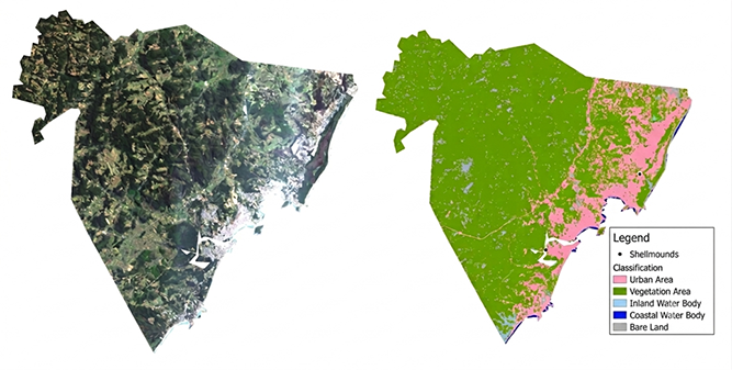 Source: LANDSAT (2025).
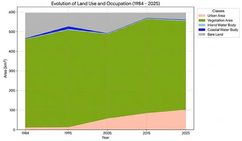 Source: Prepared by the authors (2026).
 Source: Prepared by the authors (2026).
 Source: Prepared by the authors (2026).