
 Methodology for the Selection of Springs for Revitalization in Watersheds
Abstract
The degradation of springs compromises water security, particularly in strategic regions such as the transition zone between the Atlantic Forest and the Caatinga in northeastern Brazil. This study aims to present a methodology for prioritizing springs for restoration in four river basins located between the states of Rio Grande do Norte and Paraíba (Traíri, Jacu, Curimataú, and Mamanguape). To achieve this, a cartographic approach was adopted using geospatial data from multiple sources, geoprocessing techniques, including Digital Image Processing (DIP), and a Multicriteria Decision Analysis (MCDA). A Restoration Priority Index (RPI) was proposed, considering accessibility, environmental sensitivity, conservation status, and the land tenure and social context of the springs. Out of a total of 696 springs, 511 were selected due to the strong presence of agricultural land use and a low Water Security Index (WSI). The results indicate that most springs are under significant anthropogenic pressure, primarily driven by agricultural expansion and the reduction of native vegetation cover. A total of 135 springs (26.4%) were classified as high priority for restoration, being concentrated mainly in areas subject to intense human pressure. The proposed methodology proved to be an effective and replicable tool for supporting public policies and spring restoration programs aimed at strengthening water resilience and promoting sustainable territorial development.
Keywords:
Spring Restoration; Water Resources; Geotechnologies; Multicriteria Analysis; Watersheds
Resumo
A degradação de nascentes compromete a segurança hídrica, especialmente em regiões estratégicas como a zona de transição entre a Mata Atlântica e a Caatinga no Nordeste brasileiro. O objetivo dessa pesquisa é apresentar uma metodologia de priorização de nascentes para recuperação em quatro bacias hidrográficas entre os estados do Rio Grande do Norte e Paraíba (Traíri, Jacu, Curimataú e Mamanguape). Para isso, utilizou-se de uma abordagem cartográfica, valendo-se de dados geoespaciais de múltiplas fontes, técnicas de geoprocessamento, incluindo processamento digital de imagens (PDI), bem como uma Análise de Decisão Multicritério, sendo proposto o Índice de Priorização de Recuperação (IPR), considerando as condições de acesso, sensibilidade ambiental, estado de conservação e contexto fundiário-social das nascentes. De um total de 696 nascentes, foram selecionadas 511 em que há forte presença de áreas de produção agropecuária e baixo Índice de Segurança Hídrica (ISH). Os resultados indicam que a maioria das nascentes está submetida a pressões antrópicas, sobretudo pela expansão agropecuária e pela redução da cobertura vegetal, 135 nascentes (26,4%) foram classificadas como de alta prioridade para recuperação, concentradas principalmente em áreas de intensa pressão antrópica. A metodologia se mostrou uma ferramenta eficaz e replicável para subsidiar políticas públicas e programas de restauração de nascentes, visando fortalecer a resiliência hídrica e o desenvolvimento sustentável dos territórios.
Palavras-chave:
Recuperação de nascentes; Recursos Hídricos; Geotecnologias; Análise Multicritério; Bacias Hidrográficas
INTRODUCTION
The debate surrounding environmental issues in Brazil has been intense over the past 20 years, marked by the strengthening of the National Environment Council (CONAMA), a body established in 1981, and by a vigorous public discussion that culminated, in 2012, in a new social pact for Brazilian forests, known as the "New" Forest Code, established by Law No. 12,651/2012 (BRASIL, 2012).
Over the past five years, discussions regarding global warming have been gradually replaced by an agenda addressing Climate Change, and Brazil, a tropical country of continental dimensions, has experienced events that intensify this debate. Such events include the floods that occurred in May 2024 in the state of Rio Grande do Sul, affecting 475 municipalities and 2,390,556 people, resulting in 172 deaths and 42 missing individuals, and displacing 616,800 people from their homes, according to the State Civil Defense (RIO GRANDE DO SUL, 2024). While Rio Grande do Sul was experiencing this tragedy, the National Congress was debating a Proposed Constitutional Amendment (PEC) that would allow the privatization and sale of coastal public lands (terrenos de marinha). This proposal is viewed as critical from an environmental perspective, primarily because it endangers mangroves and restinga ecosystems, as well as exacerbating socio-environmental problems driven by sea-level rise.
Although environmental problems in Brazil exhibit highly diverse characteristics, water-related issues are consistently a central factor. This connection manifests either through extreme events, characterized by heavy rainfall and significant high-magnitude urban impacts, such as floods, or through water scarcity, including prolonged dry spells and severe droughts. These conditions directly impact the population, livestock watering, and economic activities such as agriculture and industry. In this context, the watershed serves as the ideal unit for environmental planning, a standard that has been adopted by the scientific community, environmental protection agencies, and Brazilian legislation (Botelho, 2007; Brasil, 1997; Tundisi; Matsumura-Tundisi, 2011).
From this perspective, watershed revitalization, including both perennial and intermittent springs, has emerged as an excellent approach to regulate surface runoff, prevent erosion, combat the siltation of watercourses, sustain water flow within the system, mitigate flooding, and ultimately, enable the full development of economic activities such as agriculture, livestock farming, and industry.
This research focuses on watersheds located in Northeastern Brazil, between the states of Paraíba (PB) and Rio Grande do Norte (RN), due to their strategic importance for urban water supply and agricultural and livestock development. These basins are situated in the transition zone between the Atlantic Forest and Caatinga biomes, a region characterized by a diversity of land use and land cover types that reflect its environmental variability. Specifically, the study area comprises the watersheds of the following rivers: Trairi (BHRT - RN), Jacu (BHRJ - RN and PB), Curimataú (BHRC - PB), and Mamanguape (BHRM - PB).
These watersheds have been subjected to intense occupation and exploitation since the 18th century, resulting in the widespread degradation of watercourses due to the removal of vegetation cover and the destruction of springs and wetlands. In this context, a methodology for identifying and classifying restoration priorities is essential for better water resources management in the area. Such an approach can undoubtedly enhance the quality of life for local populations, support economic activities, and ensure the sustainability and quality of public water supply services, alongside the environmental benefits provided in the form of ecosystem services.
Therefore, this article aims to present a methodological approach for identifying and prioritizing springs for restoration. The specific objectives are: 1) to define and build a database that enables the identification and analysis of the environmental condition of springs at the watershed scale; 2) to develop a classification system to define priority springs for restoration, based on variables that provide a favorable cost-opportunity ratio relative to their level of degradation; and 3) to present the results of applying this identification and selection methodology, contextualizing the scenario for watersheds in the transition zone between the Atlantic Forest and the Caatinga.
STUDY AREA
The watersheds of the Trairi (RN), Jacu (RN and PB), Curimataú (RN and PB), and Mamanguape (PB) rivers cover an area of approximately 13,263.2 km2 (Figure 1) and extend across 92 municipalities in the states of Rio Grande do Norte and Paraíba - Brazil. In terms of population, the four basins were home to 1,034,366 inhabitants in 2022 (IBGE, 2024a). The principal cities include São José do Mipibu, Canguaretama, Santa Cruz, Nova Cruz, Goianinha, and Monte Alegre in RN. In PB, representative municipalities include Guarabira, Esperança, Lagoa Seca, Solânea, Alagoa Grande, Areia, Rio Tinto, and Bananeiras. Together, these cities account for 437,973 inhabitants, representing approximately 42% of the total population of the watersheds.

Location of the watersheds of the Trairi (RN), Jacu (RN and PB), Curimataú (RN and PB), and Mamanguape (PB) rivers
This area is characterized by significant social and economic dynamics relevant to the region, driven by activities and facilities such as an automotive assembly plant (Goianinha), cachaça distilleries (Areia and surrounding areas), sugarcane production (several coastal municipalities, notably Canguaretama, Areia, and Alagoa Grande), and ethanol refineries (Arês and Mamanguape). Consequently, these are strategic watersheds for the economic and social development of the states of Rio Grande do Norte and Paraíba.
METHODOLOGICAL PROCEDURES
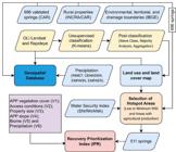
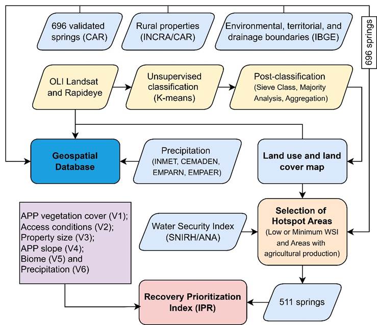
This research relied on the use of secondary data (statistical and census data); official geospatial data collected from various public agencies; and the generation of original cartographic products at scales compatible with the study's objectives. For all spatial data processed in this article, the South America Lambert Conformal Conic reference system was adopted. The methodological workflow is illustrated in the schematic flowchart of the research (Figure 2), which details all sources, products, and processes.
Data Sources
Spring Locations
The location of the springs was acquired through the download database of the National System of the Rural Environmental Registry (SICAR) (BRASIL, 2024). These data are part of the national public records of the Rural Environmental Registry (CAR), which is mandated by the Brazilian Forest Code (Federal Law 12,651/2012). From this same source, data regarding the boundaries of registered rural properties, their land use and land cover, and the mapping of Permanent Preservation Areas (APPs) were also obtained.
The collected data comprised a total of 918 springs. To ensure the precision and accuracy of the analysis, a data verification and quality assessment procedure were conducted. This evaluation was necessary due to the inherent nature of the dataset; since the information available on the SICAR platform is primarily provided by rural landowners, the vector data may present various types of topological inconsistencies.
This evaluation procedure was conducted in two stages. First, spatial duplication errors were identified, that is springs with identical and overlapping coordinates (x and y). From each set of overlapping points, only one was retained, and the duplicates were discarded. The second stage involved identifying locational patterns that were incompatible with the nature of these hydrographic features. Figure 3 illustrates an example of such inconsistency in the municipality of Solânea (PB), where 152 points registered as springs were arranged in a regular geometric pattern. These points were likely uploaded to the system by mistake and, in reality, represent the boundary vertices of a rural property.

Following the correction of spatial duplication errors and locational inconsistencies, a total of 696 springs were retained and validated across the four watersheds. These are distributed as follows: 39 in the Trairi River basin, 92 in the Jacu River basin, 155 in the Curimataú River basin, and 410 in the Mamanguape River basin.
Land Tenure Structure
In addition to the CAR dataset, land tenure data-specifically, property boundaries-were obtained from the National Institute for Colonization and Agrarian Reform (INCRA). The complete dataset of rural properties from the Land Management System (SIGEF) and the National Property Certification System (SNCI) were acquired. These data were used to derive the property size variable (INCRA, 2024).
Territorial and Environmental Boundaries, and Drainage Networks
Territorial and environmental boundaries from two different sources were utilized, all in their latest available versions and in ESRI Shapefile format. Specifically, municipal boundary data (2024 version, 1:250,000 scale) (IBGE, 2024b) and Brazilian biome boundaries (2019 version, 1:250,000 scale) were obtained from the Brazilian Institute of Geography and Statistics (IBGE, 2019). Drainage networks and other auxiliary data were also acquired from IBGE; these are part of the Continuous Cartographic Base (2023 version, 1:250,000 scale) (IBGE, 2023).
The watershed boundaries were obtained from the National Water and Sanitation Agency (ANA) via the National Water Resources Information System portal (SNIRH). Additionally, data regarding the Water Security Index (ISH) were collected from the SNIRH portal. This index evaluates micro-watersheds by categorizing their water security levels as minimum, low, medium, high, or maximum (ANA, 2025).
These datasets were utilized to understand the territorial context, establish relationships, verify the consistency of the CAR spring data, and enable spatial analysis.
Satellite Imagery
Free multispectral data from the Sentinel-2 MSI sensor, with a 10-meter spatial resolution, provided by the European Space Agency and Copernicus (ESA, 2025), were utilized. Additionally, RapidEye data, featuring a 4.7-meter spatial resolution, were acquired. Although typically commercial, these images were temporarily made available free of charge via the Planet website through a partnership involving Norway's International Climate and Forest Initiative (NICFI), Kongsberg Satellite Services, and Airbus (Planet, 2025). These datasets were used to compile the research database and, primarily, to serve as the basis for land use and land cover mapping.
Both the Sentinel-2 and RapidEye datasets were acquired using the Google Earth Engine (GEE) cloud computing platform (Gorelick et al., 2017). To mitigate atmospheric noise in the imagery, such as clouds and shadows, a temporal mosaic was generated for the year 2024. This mosaic was created by applying a statistical reduction metric (median reducer) across all available pixels throughout the year. This is a well-established methodology in literature (Pekel et al., 2016; Souza et al., 2020), as it effectively removes extreme reflectance values caused by clouds (very bright) and shadows (very dark). Furthermore, a pre-filter was applied to ensure that only scenes with less than 15% cloud cover were selected, ultimately resulting in a cloud-free composite.
For terrain modeling and the identification of slope patterns within the watersheds, radar data from the Shuttle Radar Topography Mission (SRTM) with a spatial resolution of 30 m, were acquired (USGS, 2024).
As previously mentioned, the multispectral imagery was utilized to characterize the study area in terms of land use and land cover, particularly regarding the spatial distribution of vegetation. These data were subjected to a digital image classification process, aiming to achieve a cartographic scale between 1:100,000 and 1:25,000. In turn, the radar data were used to generate slope maps, enabling the identification of general patterns in areas with varying slopes at a scale close to 1:100,000.
Precipitation Data
The precipitation data utilized in this research were obtained from rainfall stations monitored by the National Institute of Meteorology (INMET), and the National Center for Monitoring and Early Warning of Natural Disasters (CEMADEN), Additionally, data were acquired from state-level agricultural research agencies, namely the Agricultural Research Corporation of Rio Grande do Norte (EMPARN) and the Paraíba State Company for Research, Rural Extension, and Land Regularization (EMPAER) (INMET, 2024; CEMADEN, 2024; EMPARN, 2024; EMPAER, 2024).
These datasets were utilized to generate precipitation maps for the watersheds by interpolating data from meteorological stations distributed across the region for the period from 2020 to 2023.
The interpolation method applied to the precipitation point data was Topo to Raster (Hutchinson; Dowling, 1991), a technique widely used for interpolating climatological data and tested across various precipitation applications in the literature (Marcuzzo et al., 2011; Sousa et al., 2013; Santos et al., 2023).
Products and Processes
Land Use and Land Cover Mapping
The land use and land cover mapping were conducted in two stages. The first stage involved an unsupervised classification using the k-means algorithm. An unsupervised approach was chosen due to the extensive size of the study area. For this algorithm, a total of five initial classes were defined, with an acceptable error margin of 5% and ten iterations in the process.
To reduce the noise generated during the unsupervised classification, three post-classification filters were applied: sieve classes, majority analysis, and aggregation. The Sieve Classes filter targets isolated pixels in the classification through a neighborhood analysis, applying a filtering threshold of up to 10 pixels. The majority analysis filters, in turn, reclassified pixels according to the predominant classes within their vicinity. Finally, the aggregation filter was employed, which merged smaller pixel clusters into a larger group.
The second stage involved a visual inspection of the classification results. Given the vast spatial dimensions and specific characteristics of the study area, which features longitudinal watersheds, as well as varying vegetation and distinct climatic patterns between the coastal and inland regions, a manual visual inspection approach was adopted.
This inspection was conducted within a 500-meter radius of all springs to ensure greater accuracy between classification and ground reality. To support the visual inspection, RapidEye data (4.7-meter spatial resolution) were utilized instead of Landsat OLI imagery (30-meter spatial resolution). This higher-resolution imagery allows for on-scene object inference and identification with approximately 41 times greater spatial detail, significantly enhancing the evaluation and validation of the classification.
Selection of Hotspot Areas
Based on the land use and land cover map, areas of interest (hotspots) were selected through the intersection of the following criteria: (1) areas with significant agricultural activity; and (2) areas with a low or minimum ISH.
Out of the 696 springs, 511 exhibit a low or minimum ISH and are situated in areas predominantly characterized by agricultural land use (agriculture or pasture).
Ranking of Springs for Recovery and Revitalization: Recovery Prioritization Index (IPR)
To identify the priority springs for recovery, a Recovery Prioritization Index (IPR) was developed for the 511 springs using Multi-Criteria Decision Analysis (MCDA) an approach widely employed to integrate multiple spatial criteria into decision-making processes (Malczewski, 1999, 2006), the following variables were considered: 1) Relative amount of vegetation within the Permanent Preservation Area (APP) and the spring's vicinity, in hectares (500-meter radius); 2) Euclidean distance to paved roads, in meters; 3) Actual distance from the spring to a paved road, in meters; 4) Total distance from the nursery to the spring, in meters; 5) Travel time from the nursery to the spring, in minutes; 6) Property size in hectares (INCRA / Brazilian Forest Service); 7) Slope of the spring area, in percentage (SRTM); 8) Biome of the spring; 9) Mean annual precipitation (2020 to 2023), in millimeters. Consequently, these variables enabled the assessment of access conditions, environmental sensitivity, conservation status, and the socio-land tenure context.
Access conditions to the springs are a critical factor for the operational logistics of recovery actions, as they involve the transportation of seedlings and subsequent monitoring. Given the availability of four access-related metrics (variables 2 through 5), a composite variable named "access condition" was created through their normalized inverse combination. To determine the distances in meters for variables 3 and 4, as well as the travel time for variable 5, the routing tool in Google Earth Pro (Google LLC, 2026) was utilized. This procedure was executed individually for all 511 analyzed springs.
The continuous variables were normalized to a range of -1 to +1. A value of -1 indicates better environmental conditions and easier access, thus indicating a lower urgency for recovery priority. Conversely, a value of +1 signifies critical environmental conditions, equating to a higher priority for environmental recovery. This normalization process was carried out using Equation 1.
An inverse normalization was applied to the variables "relative amount of vegetation within the APP and the spring's vicinity" and "access condition". This approach was taken because less vegetation cover indicates poorer environmental conditions, thus demanding higher intervention priority. Similarly, priority was given to springs located closer to roads; their greater accessibility ensures better logistical viability for planting operations. This logistical advantage is particularly crucial since local community involvement in these initiatives is anticipated.
The categorical variable "Biome" was converted into a binary score. Springs in the Caatinga biome were assigned a value of 1 due to their inherent water vulnerability, whereas those located in the Atlantic Forest were assigned a value of -1.
Regarding property size, an average fiscal module (módulo fiscal) of 27.5 hectares was adopted. The springs were assigned scores based on INCRA's official criteria for defining small and medium-sized properties: Up to 110 ha (up to four fiscal modules): assigned a value of 1 (indicating small properties with a lower capacity for recovery); Between 110 and 275 ha (four to ten fiscal modules): assigned a value of 0; Greater than 275 ha (more than ten fiscal modules): assigned a value of -1.
For 22 springs where reliable property size data were unavailable, even after cross-referencing datasets from INCRA and the Rural Environmental Registry (CAR), the decision was made to retain them in the database. To calculate the IPR for these specific units, a proportional redistribution of the variable weights was applied, effectively omitting the property size variable from the computation.
Thus, the IPR was calculated using the weighted mean of the normalized variables (Equation 2). The weight assigned to each variable was determined through an analytical assessment, prioritizing conservation status and access conditions (Table 1). This weighting system reflects the direct impact that each factor exerts on both the urgency and the feasibility of the recovery efforts.
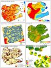
Figure 4 illustrates the geospatial datasets processed and utilized to calculate the IPR.
Finally, all 511 springs were classified into three categories based on their IPR scores: High Priority: IPR ≥ 0.4; Medium Priority: IPR between -0.4 and 0.4; Low Priority: IPR ≤ -0.4.
These values were defined to maintain symmetry across the scale (-1 to 1) while establishing a broader medium class (a range of 0.8, compared to 0.6 for the other classes). This methodological approach serves the managerial objective of isolating extreme conditions. By tightening the thresholds for the high- and low-priority classes, it ensures that only springs in a clearly critical state or with an exceptional conservation status are highlighted at the extremes. Consequently, the index avoids the overestimation of critical hotspots and focuses the ranking on those springs that genuinely require immediate allocation of resources.
RESULTS AND DISCUSSION
The unsupervised land use and land cover classification within the watersheds enabled the observation of land use dynamics and the distribution of natural land cover. A total area of 13,331 km2 was mapped across 13 classes (Figure 5 and Table 2): water, intermittent wetland, agriculture, Apicum, aquaculture, urban area, mangrove, mining, mosaic of uses, clouds, pasture, bare soil, and vegetation.

Anthropogenic land covers, such as agriculture and pasture, predominantly occupy the coastal portions of the watersheds, decreasing in extent moving inland. The agriculture (3,323 km2, or 24.9%) and pasture (1,948 km2, or 14.6%) classes are particularly notable. Among the four watersheds, only the Trairí basin exhibits a combined agriculture and pasture area of less than 1,000 km2. In contrast, the Mamanguape watershed contains the largest extents of these land uses, with 1,140 km2 of agriculture and 504 km2 of pasture, concentrated primarily in the central-eastern portion of the basin toward the coast.
An analysis of the absolute and percentage values for each watershed (Table 2) reveals that among the natural land cover classes, vegetation occupies the largest area across all four basins: 1,753 km2 in the Traíri, 1,580 km2 in the Mamanguape, 1,242 km2 in the Jacu, and 2,658 km2 in the Curimataú. Combined, vegetation covers 7,389 km2, accounting for 55.4% of the total watershed area. In addition to vegetation, the water class is notable, encompassing 196 km2 (1.5% of the total area). This class is primarily characterized by river estuaries in the coastal regions, alongside reservoirs and water surfaces distributed throughout the study area. Of this total, the Curimataú watershed stands out significantly, containing 102 km2 of the identified water bodies.
The urban area class accounts for a total of 238 km2 (1.8%) across all watersheds. However, the Mamanguape basin contains the largest urbanized extent, encompassing 88 km2 of this class.
An analysis of the land use and land cover classes within a 500-meter radius around the analyzed springs-measured in km2 and percentages-identified nine distinct classes (Table 3): water, intermittent wetland, agriculture, aquaculture, urban area, mosaic of uses, pasture, bare soil, and vegetation.
The surroundings of the analyzed springs in this study demonstrate that they are embedded in areas whose uses are oriented toward anthropogenic activities, such as agriculture and pasture. This occurs because 35.8% (1.08 km2) of the vicinity of these springs is occupied by pasture areas, 13.6% (0.41 km2) by agriculture, 6.2% (0.19 km2) by urban areas, and 3.5% (0.11 km2) by a mosaic of uses.
In contrast, 40.8% of the area within a 500-meter radius of the springs consists of natural land cover. This cover is primarily represented by the vegetation class, which occupies an area of 1.2 km2 (39.8%), followed by the water class with 0.02 km2 (0.7%) and the bare soil class with 0.01 km2 (0.3%). This demonstrates the predominance of anthropogenic pressure in the surrounding areas where the analyzed springs are embedded.
Applying the methodology proposed in this study to calculate the IPR revealed that a large proportion of the springs located in areas with active land use within the analyzed watersheds require some degree of intervention for recovery. A total of 466 springs were classified as having medium or high priority for recovery (Figure 6), presenting IPR values ranging from -0.398 to 0.750. Conversely, 45 springs were labeled as low priority for recovery, recording IPR values between -0.836 and -0.406.

These figures indicate that, overall, the springs within the watersheds comprising the study area exhibit some degree of degradation and require intervention for environmental recovery. Of the 45 springs labeled as low recovery priority, 18 are in the Mamanguape River watershed, 15 in the Trairi River watershed, 11 in the Jacu River watershed, and one in the Curimataú River watershed. It is important to highlight that among these low-priority springs, only 12 are located within the semiarid environment of the Caatinga biome, distributed across the Mamanguape (seven springs), Jacu (four springs), and Curimataú (one spring) watersheds.
Of the total number of springs, 331 were classified as medium recovery priority (~64%), distributed across all four watersheds and occupying areas of both the Caatinga and Atlantic Forest. Finally, 135 springs were labeled as high recovery priority, concentrated primarily in the Mamanguape watershed with 111 springs, followed by 14 in the Curimataú watershed, and seven and three springs in the Trairí and Jacu watersheds, respectively.
The concentration of high-priority springs in the Mamanguape basin directly correlates with the land occupation dynamics evidenced by the land use mapping. This basin contains the largest extents of agricultural areas (1,140 km2) and urban areas (88 km2). This anthropogenic pressure on the surroundings of the springs translates directly into the index, demonstrating that the coastal transition zone has not only lost a significant portion of its natural cover but also exposes its water resources to heightened risk. In contrast, the more inland areas of the Curimataú watershed, despite the climatic vulnerability inherent to the Caatinga biome, retain a higher relative vegetation cover (65.4%). This attenuates the immediate structural urgency in the IPR ranking, distributing its springs primarily across the medium-priority categories.
To evaluate the weighting scheme applied in the construction of the IPR, three weighting scenarios were tested through a sensitivity analysis: 1) Conservative, reducing the weight of V1 (relative vegetation cover within APPs and surrounding areas) from 2.5 to 2.0; 2) Operational, increasing the weight of V2 (Access Condition) from 1.5 to 2.0; and 3) Ecological, increasing the weight of V5 (Biome) from 1.0 to 1.5. In all scenarios, the remaining weights were kept constant. This approach allowed for the evaluation of the index's sensitivity to changes in the criteria deemed most strategic, yielding the outcomes presented below (Table 4).
The differences between the original IPR and the scenario modeling indicate no significant alteration in the spring prioritization pattern, a finding confirmed by Spearman's correlation, with ρ = 0.97 in the conservative scenario, ρ = 0.98 in the operational scenario, and ρ = 0.96 in the ecological scenario, which demonstrates the index's stability against moderate weight variations. When analyzing the top 20 springs with IPR values indicating a need for recovery intervention, an overlap exceeding 85% (between 17 and 18 springs) is observed across all scenarios. Therefore, no substantive changes occur in response to weight adjustments. Notably, in all alternative scenarios, the number of springs in the low-priority class decreases significantly, particularly in the conservative scenario, which reduces the weight assigned to the conservation of APPs and areas surrounding the springs. This highlights the importance of the conservation weight in effectively identifying the springs that most urgently require recovery.
CONCLUSIONS
This research developed a methodology for selecting priority springs for recovery within watersheds in the Brazilian Northeast, spanning the states of Rio Grande do Norte and Paraíba. The analysis was based on the creation of an index using Multicriteria Decision Analysis (MCDA) alongside geospatial, statistical, and cartographic data, enabling the identification of 135 springs, out of a total of 511, that present an urgent need for recovery intervention.
The results demonstrated that the majority of the springs are subjected to anthropogenic pressures, primarily driven by agricultural and pasture expansion, as well as the reduction of vegetation cover in areas that should be dedicated to preservation, such as Permanent Preservation Areas (APPs) and their surroundings. These factors are exacerbated by the water scarcity contexts typical of the Caatinga biome. This scenario compromises the provision of ecosystem services linked to water resources, the maintenance of biodiversity, and the support for local economic activities.
By combining environmental, land tenure, and operational variables, the proposed methodology emerges as a highly applicable technical-scientific tool to inform the creation of public policies and watershed environmental recovery programs, ultimately enhancing the quantity and quality of available water within these basins. Furthermore, the results and the approach can contribute to international commitments assumed by Brazil, such as the targets of the UN Decade on Ecosystem Restoration (2021-2030) and the Sustainable Development Goals (SDGs) (ONU, 2015, 2019).
In this regard, this proposal puts forward a replicable protocol for other regions and biomes, while also reaffirming the importance of spring recovery as a central strategy to strengthen water security and promote the socio-economic development capacity of these territories, taking into account their endogenous characteristics and the conservation of ecosystem services.
DATA AVAILABILITY
The data that underpin the results of this study may be made available by the corresponding author, upon duly justified request. [Silvio Braz de Sousa].
ACKNOWLEDGMENTS
The authors acknowledge the Brazilian Ministry of Integration and Regional Development (MIDR) for funding and supporting the project "Spring Restoration and Water Security in Strategic Watersheds for Urban and Industrial Water Supply in Northeastern Brazil" between 2021 and 2025. The authors also acknowledge the Coordination for the Improvement of Higher Education Personnel (CAPES) for providing financial support for the doctoral research of the second author, enabling his dedication to academic research.
References
-
AGÊNCIA NACIONAL DE ÁGUAS E SANEAMENTO BÁSICO (ANA). Sistema Nacional de Informações sobre Recursos Hídricos (SNIRH). Brasília, DF: ANA, 2025. Disponível em: https://www.snirh.gov.br /. Acesso em: 15 jan. 2025.
» https://www.snirh.gov.br - BOTELHO, R. G. M. Bacia hidrográfica e qualidade Ambiental. In: VITTE, A. C.; GUERRA, A. J. T. (org.). Reflexões sobre a geografia física no Brasil. 2. ed. Rio de Janeiro: Bertrand Brasil, 2007.
- BRASIL. Ministério do Meio Ambiente. Índice de Prioridade de restauração florestal para segurança hídrica: uma aplicação para as regiões metropolitanas da Mata Atlântica.. Brasília, DF: Ministério do Meio Ambiente - MMA, 2017.
-
BRASIL. Lei n. 9.433, de 8 de janeiro de 1997. Institui a Política Nacional de Recursos Hídricos, cria o Sistema Nacional de Gerenciamento de Recursos Hídricos, regulamenta o inciso XIX do art. 21 da Constituição Federal, e altera o art. 1º da Lei n. 8.001, de 13 de março de 1990, que modificou a Lei n. 7.990, de 28 de dezembro de 1989. Diário Oficial da União: seção 1, Brasília, DF, 9 jan. 1997. Disponível em: https://www.planalto.gov.br/ccivil_03/leis/l9433.htm Acesso em: 04 jun. 2024.
» https://www.planalto.gov.br/ccivil_03/leis/l9433.htm -
BRASIL. Lei n. 12.651, de 25 de maio de 2012. Dispõe sobre a proteção da vegetação nativa; altera as leis nºs 6.938, de 31 de agosto de 1981, 9.393, de 19 de dezembro de 1996, e 11.428, de 22 de dezembro de 2006; revoga as leis nºs 4.771, de 15 de setembro de 1965, e 7.754, de 14 de abril de 1989, e a medida provisória nº 2.166-67, de 24 de agosto de 2001; e dá outras providências. Diário Oficial da União : Brasília, DF, 28 maio 2012. Disponível em: https://www.planalto.gov.br/ccivil_03/_ato2011-2014/2012/lei/l12651.htm Acesso em: 04 jun. 2024.
» https://www.planalto.gov.br/ccivil_03/_ato2011-2014/2012/lei/l12651.htm -
BRASIL. Sistema Nacional de Cadastro Ambiental Rural (SICAR). Base pública de dados do Cadastro Ambiental Rural. Brasília, DF: Serviço Florestal Brasileiro, 2024. Disponível em: https://www.car.gov.br/publico/imoveis/index Acesso em: 15 jun. 2024.
» https://www.car.gov.br/publico/imoveis/index -
CENTRO NACIONAL DE MONITORAMENTO E ALERTAS DE DESASTRES NATURAIS (CEMADEN). Mapa Interativo do CEMADEN. São José dos Campos, SP: CEMADEN, 2024. Disponível em: https://mapainterativo.cemaden.gov.br /. Acesso em: 20 jun. 2024.
» https://mapainterativo.cemaden.gov.br -
EMPRESA PARAIBANA DE PESQUISA, EXTENSÃO RURAL E REGULARIZAÇÃO FUNDIÁRIA (EMPAER). Portal Institucional. João Pessoa, PB: EMPAER, 2024. Disponível em: https://empaer.pb.gov.br /. Acesso em: 20 jan. 2024.
» https://empaer.pb.gov.br -
EMPRESA DE PESQUISA AGROPECUÁRIA DO RIO GRANDE DO NORTE (EMPARN). Monitoramento Meteorológico. Natal, RN: EMPARN, 2024. Disponível em: https://meteorologia.emparn.rn.gov.br /. Acesso em: 20 jun. 2024.
» https://meteorologia.emparn.rn.gov.br -
EUROPEAN SPACE AGENCY (ESA). Sentinel-2. Paris: ESA, 2025. Disponível em: https://www.esa.int /. Acesso em: 15 jan. 2025.
» https://www.esa.int -
GOOGLE LLC. Google Earth Pro. Versão 7.3.7.1155 (64-bit). Moutain View, CA: Google LLC, 2026. Disponível em: https://earth.google.com/desktop /. Acesso em: 15 jan.2026
» https://earth.google.com/desktop -
GORELICK, N; HANCHER, M; DIXON, M; ILYUSHCHENKO, S; THAU, D; MOORE, R. Google Earth Engine: planetary-scale geospatial analysis for everyone. Remote Sensing of Environment, v. 202, p. 18-27, 2017. Doi: 10.1016/j.rse.2017.06.031.
» https://doi.org/10.1016/j.rse.2017.06.031. -
INSTITUTO NACIONAL DE COLONIZAÇÃO E REFORMA AGRÁRIA (INCRA). Acervo Fundiário. Brasília, DF: INCRA, 2024. Disponível em: https://acervofundiario.incra.gov.br/acervo Acesso em: 15 jan. 2025.
» https://acervofundiario.incra.gov.br/acervo -
INSTITUTO BRASILEIRO DE GEOGRAFIA E ESTATÍSTICA (IBGE). Biomas e Sistema Costeiro-Marinho do Brasil: compatível com a escala 1:250.000. Rio de Janeiro: IBGE, 2019. Disponível em: https://www.ibge.gov.br/geociencias/informacoes-ambientais/vegetacao Acesso em: 15 jan. 2024.
» https://www.ibge.gov.br/geociencias/informacoes-ambientais/vegetacao -
INSTITUTO BRASILEIRO DE GEOGRAFIA E ESTATÍSTICA (IBGE). Base cartográfica contínua do Brasil ao milionésimo, ao 1:250.000 e ao 1:100.000 (BC250): versão 2023. Rio de Janeiro: IBGE , 2023. Disponível em: https://www.ibge.gov.br/geociencias/cartas-e-mapas/bases-cartograficas-continuas.html Acesso em: 15 jan. 2025.
» https://www.ibge.gov.br/geociencias/cartas-e-mapas/bases-cartograficas-continuas.html -
INSTITUTO BRASILEIRO DE GEOGRAFIA E ESTATÍSTICA (IBGE). Sistema IBGE de Recuperação Automática - SIDRA. Censo Demográfico 2022: população residente. Rio de Janeiro: IBGE , 2024 a. Disponível em: https://sidra.ibge.gov.br Acesso em: 15 jun. 2024.
» https://sidra.ibge.gov.br -
INSTITUTO BRASILEIRO DE GEOGRAFIA E ESTATÍSTICA (IBGE). Malha Municipal 2024. Rio de Janeiro: IBGE , 2024 b. Disponível em: https://www.ibge.gov.br/geociencias/todos-os-produtos-geociencias/15774-malhas.html Acesso em: 15 jan. 2025.
» https://www.ibge.gov.br/geociencias/todos-os-produtos-geociencias/15774-malhas.html -
INSTITUTO NACIONAL DE METEOROLOGIA (INMET). Banco de Dados Meteorológicos para Ensino e Pesquisa (BDMEP). Brasília, DF: INMET, 2024. Disponível em: https://bdmep.inmet.gov.br /. Acesso em: 20 jun. 2025.
» https://bdmep.inmet.gov.br - MALCZEWSKI, J. GIS and Multicriteria Decision Analysis. New York: John Wiley & Sons, 1999.
-
MALCZEWSKI, J. GIS-based multicriteria decision analysis: a survey of the literature. International Journal of Geographical Information Science, v. 20, n. 7, p. 703-726, 2006. Doi: 10.1080/13658810600661508
» https://doi.org/10.1080/13658810600661508 -
MARCUZZO, F; ANDRADE, L; MELO, D. Métodos de Interpolação Matemática no Mapeamento de Chuvas do Estado do Mato Grosso (Interpolation Methods in Mathematics of Rainfall Mapping of the State of Mato Grosso). Revista Brasileira de Geografia Física, v. 4, n. 4, p. 793-804, 2012. Doi: 10.26848/rbgf.v4i4.232714
» https://doi.org/10.26848/rbgf.v4i4.232714 - ORGANIZAÇÃO DAS NAÇÕES UNIDAS (ONU). Transformando nosso mundo: a Agenda 2030 para o Desenvolvimento Sustentável. Nova York: ONU, 2015.
-
ORGANIZAÇÃO DAS NAÇÕES UNIDAS (ONU). United Nations Decade on Ecosystem Restoration (2021-2030). Resolução A/RES/73/284 da Assembleia Geral das Nações Unidas, de 1º de março de 2019. Nova York: ONU , 2019. https://digitallibrary.un.org/record/3794317?v=pdf&ln=es
» https://digitallibrary.un.org/record/3794317?v=pdf&ln=es -
PEKEL, JF.; COTTAM, A.; GORELICK, N.; BELWARD, A.S. High-resolution mapping of global surface water and its long-term changes. Nature 540, 418-422 (2016). Doi: 10.1038/nature20584
» https://doi.org/10.1038/nature20584 -
PLANET LABS PBC . Norway's International Climate and Forest Initiative (NICFI) Satellite Data Program. San Francisco: Planet. Disponível em: https://www.planet.com/nicfi /. Acesso em: 14 jan. 2025.
» https://www.planet.com/nicfi - RIO GRANDE DO SUL. Casa Militar. Subchefia de Proteção e Defesa Civil. Boletim divulgado pela defesa Civil. Porto Alegre: Governo do Estado do Rio Grande do Sul, 2024.
- SANTOS, D. C. A.; SOUSA, S. B.; Arantes, A. E.; AMORIM, R. F.; COSTA, C. W. Análise comparativa de qualidade de dados de estações pluviométricas automáticas e convencionais do INMET e dados do satélite GPM para o RN, Brasil (2017). Sociedade e Território, v. 34, p. 53-74, 2023.
- SOUSA, S. B.; ARANTES, A. E.; CARDOSO, M. R. D.; FERREIRA, L . Análise comparativa entre dados TRMM e estações pluviométricas no Pantanal brasileiro: ano-base 2006. In: SIMPÓSIO BRASILEIRO DE SENSORIAMENTO REMOTO, 16, 2013, Foz do Iguaçu. Anais do XVI Simpósio Brasileiro de Sensoriamento Remoto. São José dos Campos: INPE, 2013. p. 6945-6952.
-
SOUZA JR., C. M.; SHIMBO, J. Z.; ROSA, M. R.; PARENTE, L. L.; ALENCAR, A. A.; RUDORFF, B. F. T.; HASENACK, H.; MATSUMOTO, M.; FERREIRA, L. G.; SOUZA-FILHO, P. W. M.; OLIVEIRA, S. W. de; ROCHA, W. F.; FONSECA, A. V.; MARQUES, C. B.; DINIZ, C. G.; COSTA, D.; MONTEIRO, D.; ROSA, E. R.; VÉLEZ-MARTIN, E.; WEBER, E. J.; LENTI, F. E. B.; PATERNOST, F. F.; PAREYN, F. G. C.; SIQUEIRA, J. V.; VIERA, J. L.; FERREIRA NETO, L. C.; SARAIVA, M. M.; SALES, M. H.; SALGADO, M. P. G.; VASCONCELOS, R.; GALANO, S.; MESQUITA, V. V.; AZEVEDO, T. Reconstructing three decades of land use and land cover changes in Brazilian biomes with Landsat archive and Earth Engine. Remote Sensing, v. 12, n. 17, art. 2735, 2020. Doi: 10.3390/rs12172735
» https://doi.org/10.3390/rs12172735 - TUNDISI, J. G.; MATSUMURA-TUNDISI, T. Recursos hídricos no século XXI. São Paulo: Oficina de Textos, 2011.
-
UNITED STATES GEOLOGICAL SURVEY (USGS). Shuttle Radar Topography Mission (SRTM) 1 Arc-Second Global. Reston, VA: USGS. Disponível em: https://earthexplorer.usgs.gov /. Acesso em: 22 jun. 2024.
» https://earthexplorer.usgs.gov

 Source: Prepared by the authors (2025).
 Source: Prepared by the authors (2025).
 Source: Prepared by the authors (2026).
 Source: Prepared by the authors (2025).
 Source: Prepared by the authors (2025).
 Source: Prepared by the authors (2025).