
 The Atlantic Forest Loss and Coastal Conservation Challenges on the Southeast Brazilian Coast
Abstract
Coastal regions play a crucial role in global biodiversity conservation and human development, yet they face growing threats from urbanization, industrialization, and habitat loss. The Atlantic Forest, a biodiversity hotspot along Brazil’s southeastern coast, has been severely reduced by long-term anthropogenic pressures. This study analyzes spatiotemporal dynamics of Atlantic Forest cover and urban expansion in the Baixada Santista watershed over three decades. Using supervised classification of satellite imagery, we quantified changes in forest cover and identified key drivers of deforestation and regeneration. Results reveal forest loss followed by partial recovery, resulting in a net reduction of 1.21 km² between 1991 and 2021. Urban expansion and informal settlements were the main drivers of vegetation loss, especially in sub-basins associated with the Santos-São Vicente Estuarine complex and industrial zones. Mangrove ecosystems in industrialized areas also showed significant degradation, highlighting the need for integrated conservation strategies, improved urban planning, and habitat restoration.
Keywords:
Tropical forest; biodiversity hotspot; ecosystem services; settlements; Baixada Santista
Resumo
As regiões costeiras desempenham papel crucial na conservação da biodiversidade global e no desenvolvimento humano, porém enfrentam ameaças crescentes decorrentes da urbanização, industrialização e perda de habitats. A Mata Atlântica, hotspot de biodiversidade ao longo da costa sudeste do Brasil, foi severamente reduzida por pressões antrópicas de longo prazo. Este estudo analisa a dinâmica espaço-temporal da cobertura da Mata Atlântica e da expansão urbana na bacia hidrográfica da Baixada Santista ao longo de três décadas. Por meio de classificação supervisionada de imagens de satélite, quantificaram-se as mudanças na cobertura florestal e identificaram-se os principais vetores de desmatamento e regeneração. Os resultados revelam perda florestal seguida de recuperação parcial, resultando em redução líquida de 1,21 km² entre 1991 e 2021. A expansão urbana e os assentamentos informais foram os principais responsáveis pela perda de vegetação, especialmente em sub-bacias associadas ao complexo estuarino Santos-São Vicente e zonas industriais
Palavras-chave:
Floresta tropical; hotspot biodiversidade; serviços ecossistêmicos; assentamentos; Baixada Santista
Resumen
Las regiones costeras desempeñan un papel crucial en la conservación de la biodiversidad global y el desarrollo humano, pero enfrentan amenazas crecientes por la urbanización, industrialización y pérdida de hábitats. La Mata Atlántica, hotspot de biodiversidad en la costa sudeste de Brasil, fue severamente reducida por presiones antrópicas prolongadas. Este estudio analiza la dinámica espaciotemporal de la cobertura de la Mata Atlántica y la expansión urbana en la cuenca de la Baixada Santista durante tres décadas. Mediante la clasificación supervisada de imágenes satelitales, se cuantificaron los cambios en la cobertura forestal y se identificaron los impulsores de deforestación y regeneración. Los resultados muestran pérdida forestal seguida de recuperación parcial, con reducción neta de 1,21 km² entre 1991 y 2021. La expansión urbana y asentamientos informales causaron pérdida de vegetación, especialmente en subcuencas asociadas al complejo estuarino Santos-São Vicente y zonas industriales, y reforzaron la necesidad de planificación territorial integrada y conservación ambiental sostenible.
Palabras-clave:
Bosque tropical; hotspot de biodiversidad; servicios ecosistémicos; asentamientos; Baixada Santista
Introduction
Coastal areas encompass nearly 20% of the Earth’s surface (Cohen et al., 1997), accommodating around 50% of the human population within 200 km of the coast (United Nations, 2011; Brown et al., 2013). These ecosystems contribute over half of the total value of ecosystem services (Costanza et al., 1997), yet they are facing degradation and unsustainable usage (UNEP, 2006). The burgeoning development in coastal regions is primarily fuelled by urban and port expansions, with a notable concentration of industries, particularly chemical plants, along the coast (ANCORIM, 2020). The rapid urban population growth in coastal zones has led to an expansion of built-up areas to meet the escalating demand for housing and public amenities, exacerbating the degradation of ecological spaces, such as mangrove ecosystems (Al et al., 2020).
The coastal population is expected to continue growing due to global urbanization trends and population growth (Melet et al., 2020), which will exacerbate the negative impacts on coastal zones (Diegues, 1999). This scenario is pronounced along the Brazilian coast, which spans 8,512 km² (Dominguez, 2006) and is home to approximately 18% of the nation’s population, with 16 out of 28 metropolitan regions situated along the coast (Nicolodi & Petterman, 2011). Approximately 300 coastal municipalities face the ocean (Diegues, 1999), and roughly 80% of the country’s population resides in the Atlantic Forest domain (IBGE, 2014).
The Atlantic Forest is the second-largest tropical forest in South America (Ribeiro et al., 2009) and is home to over 15,000 plant species, with approximately 82% of these species endemic to the region (Lima et al., 2024). Historical pressures from urban, industrial, and agricultural expansion have resulted in the loss of more than 80% of its original vegetation cover (Rezende et al., 2018). As a result, over 80% of the remaining forest is composed of small fragments, typically around 50 hectares in size (Ribeiro et al., 2009), and at least 23% of all endemic plant species are currently at risk of extinction (Brasil, 2022). Due to these factors, the Atlantic Forest is considered one of the world’s most threatened biodiversity hotspots (Myers et al., 2000) and is a high priority for conservation efforts (Brancalion et al., 2019; Rosa et al., 2021). Simultaneously, more than 65% of Brazil’s population resides within the Atlantic Forest biome, which provides essential ecosystem services that support the nation’s economic development (Resende et al., 2024).
Around two-thirds of Brazil’s industrial economy is concentrated in the Atlantic Forest, which harbors some of South America’s largest urban centers (e.g., São Paulo and Rio de Janeiro) (Joly et al., 2014). Most heavy industries (chemical, petrochemical, fertilizer) are in estuaries, bays, and other delicate coastal ecosystems (Diegues, 1999). Projections anticipate a 160% increase in urban areas within this hotspot by 2030 (Seto et al., 2012), with approximately 20% of this expansion encroaching upon current natural habitats (McDonald et al., 2018), heightening the vulnerability of the Atlantic Forest’s biodiversity and ecosystem services to degradation (Lembi et al., 2020).
The Baixada Santista watershed, encompassing the group of cities near Santos, is located within one of the largest centers of endemism in the Atlantic Forest (Tabarelli & Mantovani, 1999). As one of the four metropolitan regions of São Paulo, this area is recognized for its high vegetation cover index (São Paulo, 2020a). It is home to Brazil’s largest commercial port, the Port of Santos, and a significant petrochemical complex situated along the estuary and coastal plains, making it highly susceptible to urban and industrial expansion (Oscar-Júnior et al., 2019). With a population density of 1.8 million people (IBGE, 2024) and a complex geomorphology, the Baixada Santista is considered highly vulnerable (Nicolodi & Pettermann, 2011).
Understanding the dynamics of native forest loss and regeneration is critical for biodiversity conservation, especially in regions experiencing significant forest transformation (Rosa et al., 2021). Changes in vegetation cover can be assessed using remote sensing techniques, including the supervised classification of satellite imagery (Hüttich et al., 2011). Remote sensing is an essential tool for monitoring vegetation changes, particularly in areas with limited accessibility. It provides valuable insights that inform the development of effective management and conservation strategies aimed at mitigating environmental degradation (Johansen et al., 2007).
Given the importance of analyzing the variability of Atlantic Forest cover along the coast to prevent deforestation and degradation of ecosystem services (Brancalion et al., 2019), this study examines the spatiotemporal patterns of Atlantic Forest cover and urban expansion in the Baixada Santista over the past three decades. We employed supervised classification of satellite images to achieve this objective. We aim to support the governance of the Baixada Santista coast by promoting Atlantic Forest conservation and providing valuable insights for decision-makers to formulate sustainable land-use and urban-planning policies.
Methods
Study Site
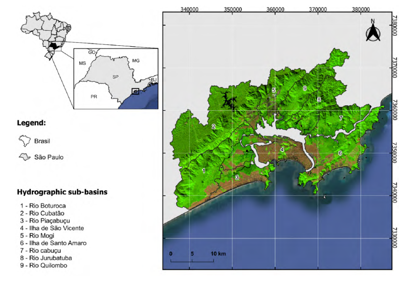
The Baixada Santista watershed spans an area of 2,422.76 km² and is situated on the central coast of São Paulo state in southeastern Brazil. Approximately 79.1% of the watershed is covered by the Atlantic Forest (São Paulo, 2020), renowned for its high richness and diversity of tree and shrub species. This biodiversity is largely attributed to the region’s varied habitats, represented by distinct plant physiognomies (Leitão-Filho, 1992). According to the “Atlas dos Remanescentes Florestais da Mata Atlântica” (Fundação SOS Mata Atlântica, 2020), the Atlantic Forest types found in this area include Dense Ombrophilous Forest (in the coastal plain), Submontane Dense Ombrophilous Forest (at elevations between 50 and 500 meters), Upper Montane Forest (above 500 meters), as well as restingas and mangroves. The study area within the Baixada Santista comprises nine hydrographic sub-basins, which encompass the municipalities of Santos, São Vicente, Cubatão, Guarujá, and Praia Grande - regions characterized by the highest levels of industrial and commercial development (CBH-BS, 2021) (Figure 1).
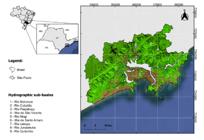
Location of the Baixada Santista watershed on the coast of the state of São Paulo, southeast Brazil. UTM coordinate system, WGS 84. Image from Landsat 8 Satellite (composition of bands 6, 5, and 4). The magenta color represents urban occupation in the region, and the green color represents the Atlantic Forest.
The municipalities comprising the study area are considered the primary drivers of economic development in the Baixada Santista. They are highly susceptible to urban expansion, fueled by the real estate boom driven by seasonal demand and the construction of large-scale infrastructure and industries in the region (Oscar-Júnior et al., 2019). Due to the historical land use associated with steel and petrochemical industries, and the presence of the Port of Santos, the Santos Estuarine System has become a prominent example of water degradation and air pollution in Brazil (Conti et al., 2016). It is important to note that the study area does not possess significant agricultural potential (Cunha & Oliveira, 2015). The rural areas within the region, primarily devoted to banana production, are mainly located along the southern coast (Gigliotti & Oliveira, 2015), which lies outside the boundaries of the study site.
Remote Sensing Analysis
The temporal variability of Atlantic Forest cover in the Baixada Santista was analyzed over 30 years, using data from 1991, 2001, 2011, and 2021. Landsat imagery for these years was obtained from the USGS Earth Explorer (https://earthexplorer.usgs.gov/) for the sub-basins of Ilha de São Vicente, Ilha de Santo Amaro, Rio Piaçabuçu, Rio Cabuçu, Rio Boturoca, Rio Cubatão, Rio Mogi, Rio Quilombo, and Rio Jurubatuba. The details and characteristics of the data are shown in Table 1.
We aimed to acquire images with minimal cloud cover across the study area. Using QGIS 3.16, a mosaic was generated by integrating available bands from each of the three sensors, employing spatial clipping of the nine watersheds provided by the Baixada Santista Hydrographic Basin Committee. Image classification was conducted using a supervised classification method for each year of sampling via QGIS (Congedo, 2016) and the Dzetsaka algorithm (Gaussian Mixture Model) (Karasiak & Perbet, 2018). For the analysis, we utilized compositions of simulated natural colours RGB 5, 4, and 3 for the years 1991, 2001, and 2011 (Landsat 5 and 7), and 6, 5, and 4 for the year 2021 (Landsat 8). Three land use and occupation classes were delineated for each study year: (1) Atlantic Forest vegetation cover, (2) water resources, and (3) urban occupation/exposed soil. Subsequently, the areas (in km²) corresponding to vegetation cover were quantified for each study year. Rural areas were not included in the analysis due to their absence within the study site.
Based on local knowledge of the region and through field visits in some locations, 100 polygons were delimited for each classified use in the images to validate supervised classification and generate standard error matrices through Total Accuracy (Overall Accuracy) using the Accuracy Assessment of Thematic Maps - AcaTama plugin (Llano, 2019). Post-algorithm application, classified results were simplified to two classes: with vegetation= 1 and without vegetation= 0. Finally, these were subtracted from each other to depict areas of vegetation cover loss and areas with no change over the years.
Results
The analysis of Atlantic Forest cover across the hydrographic sub-basins of the Baixada Santista watershed over the past 30 years reveals dynamic patterns of loss and regeneration (Table 2). In 1991, the total vegetation cover was 707.33 km². By 2001, there was an overall increase of 27.98 km², reaching 735.31 km². However, this gain was followed by a decline to 725.35 km² in 2011, with further reduction to 706.12 km² by 2021. Despite periods of partial recovery, the study indicates a net loss of 1.21 km² over the entire period, highlighting the persistent pressures on forest conservation in the region.
The variation in forest cover differed across hydrographic sub-basins, with three (Rio Boturoca, Rio Mogi, and Rio Cubatão) showing a net gain, while the others experienced losses of varying magnitudes. The Ilha de Santo Amaro sub-basin exhibited the most significant reduction in vegetation cover (-5.06 km²), followed by Ilha de São Vicente (-0.95 km²) and Rio Piaçabuçu (-0.72 km²), indicating forest loss and urban expansion in these areas. In contrast, the Rio Cubatão sub-basin recorded the highest gain (+4.55 km²), suggesting localized regeneration or conservation efforts.
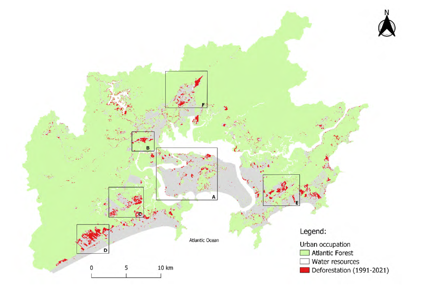
Forest loss was widespread across most hydrographic sub-basins, except Rio Boturoca, Rio Mogi, and parts of Rio Cubatão, where net gains were observed. Figure 2 illustrates these trends, highlighting six key areas where forest cover declined significantly: A - Ilha de São Vicente hydrographic sub-basin; B/D - Rio Boturoca hydrographic sub-basin; C - Rio Piaçabuçu hydrographic sub-basin; E - Ilha de Santo Amaro hydrographic sub-basin; F - Rio Mogi hydrographic sub-basin. These locations, marked by urban and industrial expansion, represent priority areas for conservation and restoration efforts.
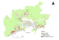
Supervised classification of Atlantic Forest cover in the Baixada Santista region from 1991 to 2021. A - Ilha de São Vicente hydrographic sub-basin; B/D - Rio Boturoca hydrographic sub-basin; C - Rio Piaçabuçu hydrographic sub-basin; E - Ilha de Santo Amaro hydrographic sub-basin; F - Rio Mogi hydrographic sub-basin.
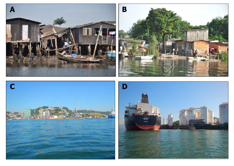
Field validations confirmed that forest loss was predominantly driven by unregulated urban expansion and informal settlements encroaching on vulnerable landscapes, including slopes, hilltops, and the margins of the Santos-São Vicente Estuarine Complex (Figure 3).
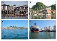
Irregular urban settlements and port occupation in the Baixada Santista. A - Settlements on mangrove area in Rio Cubatão (photo by Vinicius Cantarelli); B - Settlements on mangrove area in Rio Jurubatuba (photo by Vinicius Cantarelli); C - Construction of port terminals on mangrove areas in the Ilha de São Vicente, nearby to the Port of Santos (Author’s photo); D - Construction of port terminals on mangrove areas in the Rio Jurubatuba (Author’s photos).
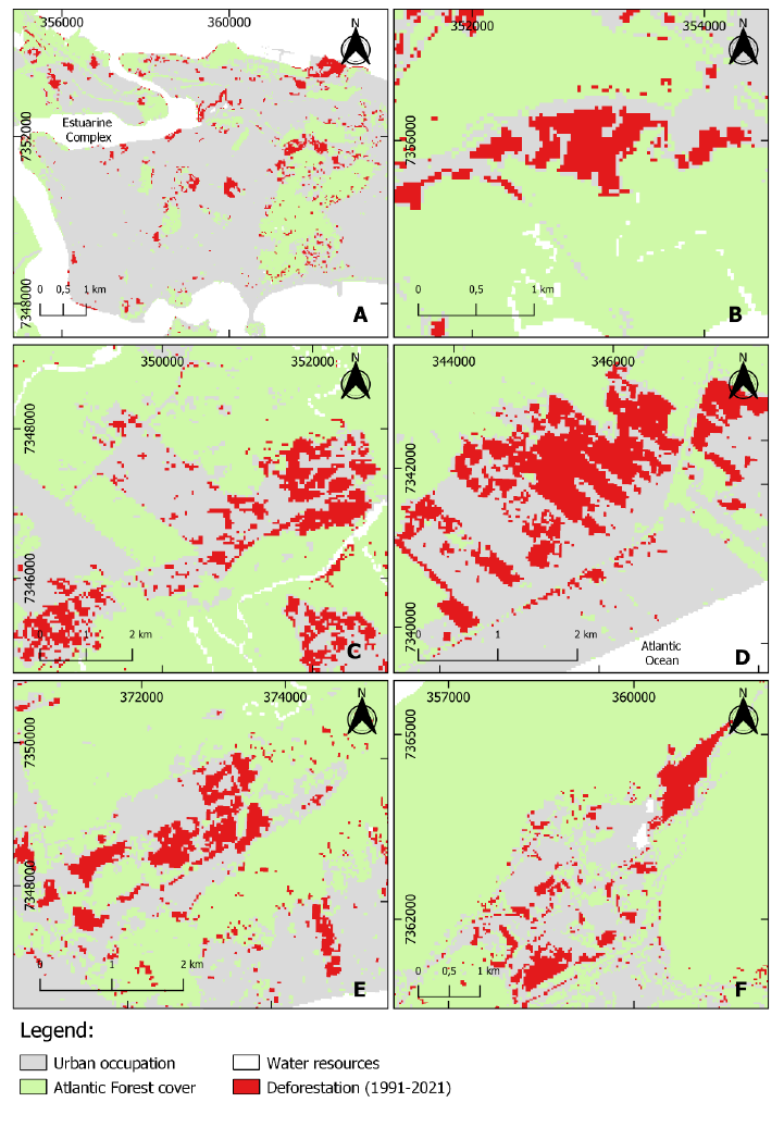
This trend was most pronounced in the Ilha de São Vicente sub-basin (Fig. 4-A), where high population density and housing demand have intensified land-use pressure. Additionally, significant mangrove loss was detected in the industrialized areas of Cubatão, particularly within the Rio Boturoca sub-basin (Fig. 4-B) and Ilha de São Vicente (Fig. 4-E). The coastal plains of the Rio Piaçabuçu (Fig. 4-C) and Rio Boturoca (Fig. 4-D) sub-basins also exhibited substantial deforestation, primarily due to urban expansion. Meanwhile, the Rio Mogi sub-basin (Fig. 4-F) experienced vegetation loss linked to industrial and logistical developments.
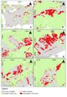
Forest cover loss in the Baixada Santista watershed from 1991 to 2021. A - Urban expansion in Santos, Ilha de São Vicente sub-basin; B - urban expansion in Cubatão, Rio Boturoca sub-basin; C - urban expansion in Rio Piaçabuçu sub-basin; D - urban expansion in Rio Boturoca sub-basin; E - urban expansion on the Ilha de Santo Amaro sub-basin; F - industrial expansion in Rio Mogi sub-basin. UTM coordinate system, WGS 84.
These findings underscore the pressing need for integrated urban planning and conservation strategies to mitigate further forest degradation. The spatial distribution of deforestation suggests that unregulated land occupation, coupled with industrial expansion, remains a critical challenge for sustainable land management in the region.
Discussion
The decline in the Atlantic Forest cover across most hydrographic sub-basins of the Baixada Santista in recent years is primarily linked to the expansion of irregular urban settlements (São Paulo, 2007; Cunha & Oliveira, 2015). Uncontrolled residential growth, particularly on the slopes and hilltops of Ilha de São Vicente, has placed local populations in increasingly vulnerable situations by exacerbating landslide risks (Marengo et al., 2019). Landslides, especially on steep terrains, have increased across Brazil in recent decades, transforming coastal disasters into a growing political and social concern (Bowen et al., 2006). Similarly, urban expansion in the Rio Boturoca sub-basin, particularly near riverbanks, has intensified flood risks during the rainy season, further endangering local communities (Cunha & Oliveira, 2015).
Irregular urban development also poses a major threat to forest cover in the Rio Quilombo, Rio Jurubatuba, Rio Cabuçu, and Ilha de Santo Amaro sub-basins (Cunha & Oliveira, 2015; Santos, 2021). Within the estuarine system, more than 10.6 km² of mangrove forests in Baixada Santista have been degraded due to unregulated settlements, particularly those occupied by low-income populations living in stilt houses (known as palafitas or favelas) (Moschetto et al., 2021). The number of people residing in precarious settlements has risen across Brazil, driven by inadequate land-use planning, the proliferation of irregular occupations, and insufficient governmental intervention in housing policies to prevent habitation in high-risk areas (Saito, 2019). Additionally, municipal-level land speculation lobbies exert strong influence, especially along the Brazilian coast, often prioritizing economic interests over environmental sustainability (Diegues, 1999). As a result, both human communities and critical mangrove ecosystems remain at risk, heightening social and ecological vulnerabilities (UNEP, 2006).
Beyond urban expansion, industrial and port-related activities have significantly contributed to mangrove deforestation. Over the past two decades, approximately 60% of Baixada Santista’s mangrove forests have been lost due to harbor and industrial development (Conti et al., 2016). The construction of port terminals in mangrove areas alone has resulted in the removal of more than 3 hectares of vegetation cover (Moschetto et al., 2021). Furthermore, the remaining mangrove forests in the estuary face continued threats, as the planned expansion of the Port of Santos-authorized by the Ministry of Infrastructure’s Ordinance No. 66/2022-seeks to nearly double the port’s dry area from 8 km² to 15.5 km² (Brasil, 2022).
Although Brazilian Law No. 12.651 (Native Vegetation Protection Law - NVPL) establishes regulations for mangrove conservation, it also permits deforestation for public utility purposes, including infrastructure projects for transportation, sanitation, energy, and the regularization of informal urban settlements (Brasil, 2012). While municipalities hold the potential to implement more stringent protective measures, local authorities’ capacity to enforce environmental legislation remains limited (Ferreira & Lacerda, 2016). Strengthening governance mechanisms and integrating public policies that reconcile Atlantic Forest conservation with sustainable land regularization efforts are crucial steps toward mitigating environmental degradation and social vulnerability in the region (Santos, 2021).
Between 2011 and 2021, forest loss in the Rio Mogi sub-basin was primarily driven by industrial expansion, closely linked to the high concentration of industrial activities in Cubatão and facilitated by environmental licensing processes (Moreira et al., 2019). In this region, remnants of the Atlantic Forest persist mainly on hilltops and steep slopes, where accessibility challenges limit commercial activities (Moreno et al., 2003). To mitigate the environmental impacts of industrial and commercial expansion, the implementation of tax and credit incentives, as outlined in Law No. 12.651/2012, could encourage businesses to adopt conservation measures for coastal ecosystems (Brasil, 2012).
Despite the enactment of Federal Law No. 11.428/2006, which regulates the protection and sustainable use of the Atlantic Forest’s biodiversity and resources, significant forest loss has continued across the region (Brasil, 2006). This legislation replaced Ordinance No. 750/1993 with similar conservation objectives (Brasil, 1993). However, the ongoing deforestation, compounded by urban expansion, threatens landscape connectivity, alters microclimates, and degrades the quantity and quality of remaining natural ecosystems (Lembi et al., 2020). Given these challenges, it is crucial to prioritize restoration and regeneration strategies to prevent further ecosystem loss (Rudd et al., 2002).
In contrast, the increase in Atlantic Forest cover between 1991 and 2001 can be largely attributed to large-scale restoration efforts led by the Companhia Ambiental do Estado de São Paulo (CETESB) in the 1980s. These initiatives focused on rehabilitating areas severely degraded by industrial pollution, particularly within the Rio Mogi and Rio Cubatão sub-basins (São Paulo, 2018). A significant portion of these reforestation efforts occurred within the Parque Estadual da Serra do Mar, a protected area designed for safeguarding over 50% of the region’s remaining forest cover. However, even within this conservation unit, irregular urban settlements by low-income populations persist, highlighting the social and environmental challenges tied to land occupation and forest conservation (Cunha & Oliveira, 2015).
The findings of this study underscore the complex interplay between urban expansion, industrial development, and environmental degradation in the Baixada Santista region. The persistent loss of Atlantic Forest and mangrove ecosystems highlights the urgent need for more effective land-use planning, stricter environmental enforcement, and integrated public policies that balance economic development with ecological resilience. Without decisive action, the continued encroachment of irregular settlements and the expansion of port and industrial infrastructure will not only accelerate habitat loss but also exacerbate social vulnerabilities, increasing the risks of landslides, flooding, and the displacement of marginalized communities. Strengthening governance, promoting sustainable urbanization, and fostering community engagement in conservation efforts are essential to fostering a more sustainable and equitable coastal landscape while ensuring the long-term sustainability of the Atlantic Forest biodiversity hotspots.
Conclusions
Urban and industrial expansion are the primary drivers of Atlantic Forest loss in Baixada Santista, exerting significant pressure on this critical biodiversity hotspot. Unregulated growth encroaches upon forested areas, undermining biodiversity and compromising essential ecosystem services vital for regional sustainability. The expansion of informal settlements accelerates habitat degradation, exacerbates environmental pressures, and disrupts the delicate ecological balance. To mitigate further deforestation caused by industrial expansion and infrastructure development, it is imperative to strengthen environmental monitoring and enforcement by regulatory agencies.
Integrating housing policies with conservation strategies is essential for curbing irregular urban sprawl while improving living conditions for vulnerable communities. A promising approach involves the establishment of Municipal Atlantic Forest Plans, which have proven effective at the local level in promoting the protection and restoration of forest remnants, even within urbanized landscapes. Santos is the only municipality within the study area to have implemented such a plan, underscoring the urgent need to extend this initiative to other municipalities in the Baixada Santista watershed. Additionally, the development of mechanisms to support land regularization is crucial. This could include creating comprehensive geospatial databases to monitor areas under environmental pressure or occupied by informal settlements, facilitating targeted and proactive interventions.
Expanding satellite-based deforestation monitoring systems to encompass other metropolitan regions and watersheds with significant vegetation cover is also vital. These systems can detect subtle land-use changes, including the gradual loss of smaller Atlantic Forest remnants, enabling timely conservation actions. Enhancing monitoring capabilities will allow for more effective identification and mitigation of threats to forest ecosystems, ensuring informed decision-making for long-term conservation and management strategies.
Safeguarding the Atlantic Forest in Baixada Santista demands a bold and integrated approach that bridges urban planning, environmental conservation, and law enforcement. Strengthening land regularization policies, accelerating restoration initiatives, and advancing real-time monitoring are not just conservation strategies-they are essential to securing the region’s biodiversity and the life-sustaining ecosystem services it provides. The future of this critical biome hinges on decisive action, where ecological preservation and sustainable development must no longer be seen as opposing forces but as interdependent pillars of a thriving and resilient landscape.
Acknowledgments
We thank Coordenação de Aperfeiçoamento de Pessoal de Nível Superior - CAPES for the scholarship, Vinicius Cantarelli for the fotos and Aynara Ribeiro de Andrade for support with graphical abstract.
References
-
AGEM. (2013). Plano metropolitano de desenvolvimento estratégico da Baixada Santista (2014-2030): Mapa de uso e ocupação do solo - território. Agência Metropolitana da Baixada Santista. http://www.agem.sp.gov.br/pmdebs/
» http://www.agem.sp.gov.br/pmdebs/ -
Ai, B., Ma, C., Zhao, J., & Zhang, R. (2020). The impact of rapid urban expansion on coastal mangroves: A case study in Guangdong Province, China. Frontiers of Earth Science, 14(1), 37-49. https://doi.org/10.1007/s11707-019-0768-6
» https://doi.org/10.1007/s11707-019-0768-6 -
ANCORIM. (2020). Decision making and coastal risks: A good practice guide. Atlantic Network for Coastal Risks Management. http://www.coop-atlantico.com/
» http://www.coop-atlantico.com/ -
Bowen, R., Frankic, A. M., & Davis, M. E. (2006). Human development and resource use in the coastal zone: Influences on human health. Oceanography, 19(2). https://doi.org/10.5670/oceanog.2006.66
» https://doi.org/10.5670/oceanog.2006.66 -
Brancalion, P. H. S., Meli, P., Tymus, J. R. C., et al. (2019). What makes ecosystem restoration expensive? A systematic cost assessment of projects in Brazil. Biological Conservation, 245, 108274. https://doi.org/10.1016/j.biocon.2019.108274
» https://doi.org/10.1016/j.biocon.2019.108274 -
Brasil. (1993). Decreto nº 750, de 10 de fevereiro de 1993. Dispõe sobre o corte, a exploração e a supressão de vegetação primária ou em estágios avançado e médio de regeneração da Mata Atlântica. https://www.planalto.gov.br/ccivil_03/decreto/1990-1994/d750.htm
» https://www.planalto.gov.br/ccivil_03/decreto/1990-1994/d750.htm -
Brasil. (2006). Lei nº 11.428, de 22 de dezembro de 2006. Dispõe sobre a utilização e proteção da vegetação nativa do Bioma Mata Atlântica. https://www.planalto.gov.br/ccivil_03/_ato2004-2006/2006/lei/l11428.htm
» https://www.planalto.gov.br/ccivil_03/_ato2004-2006/2006/lei/l11428.htm -
Brasil. (2012). Lei nº 12.651, de 25 de maio de 2012. Dispõe sobre a proteção da vegetação nativa. https://www.planalto.gov.br/ccivil_03/_ato2011-2014/2012/lei/l12651.htm
» https://www.planalto.gov.br/ccivil_03/_ato2011-2014/2012/lei/l12651.htm -
Brasil. (2022a). Portaria nº 66, de 18 de janeiro de 2022. Define a área do Porto Organizado de Santos. Ministério da Infraestrutura. https://www.in.gov.br/web/dou/-/portaria-n-66-de-18-de-janeiro-de-2022-374991416
» https://www.in.gov.br/web/dou/-/portaria-n-66-de-18-de-janeiro-de-2022-374991416 -
Brasil. (2022b). Portaria nº 148, de 7 de junho de 2022. Atualiza a Lista Nacional de Espécies Ameaçadas de Extinção. Ministério do Meio Ambiente. https://www.gov.br/icmbio/pt-br/assuntos/centros-de-pesquisa/aves-silvestres/arquivos/portaria-148-2022.pdf
» https://www.gov.br/icmbio/pt-br/assuntos/centros-de-pesquisa/aves-silvestres/arquivos/portaria-148-2022.pdf - Brown, S., Nicholls, R., Woodroffe, C., et al. (2013). Sea level rise impacts and responses: A global perspective. In C. W. Finkl (Ed.), Coastal hazards (pp. 117-149). Springer.
-
CBH-BS. (2021). Relatório de situação dos recursos hídricos da Bacia Hidrográfica da Baixada Santista. Comitê da Bacia Hidrográfica da Baixada Santista. https://sigrh.sp.gov.br/public/uploads/deliberation/CBHBS/21657/rs2021_formatado_rev11.pdf
» https://sigrh.sp.gov.br/public/uploads/deliberation/CBHBS/21657/rs2021_formatado_rev11.pdf -
Cohen, J. E., Small, C., Mellinger, A., et al. (1997). Estimates of coastal populations. Science, 278(5341), 1209-1213. https://doi.org/10.1126/science.278.5341.1209c
» https://doi.org/10.1126/science.278.5341.1209c -
Congedo, L. (2016). Semi-automatic classification plugin documentation (Version 5.0.0.1). https://www.researchgate.net/publication/265031337
» https://www.researchgate.net/publication/265031337 -
Conti, L. A., de Araújo, C. A., & Cunha-Lignon, M. (2016). Spatial database modeling for mangrove forests mapping: Example of two estuarine systems in Brazil. Modeling Earth Systems and Environment, 2, 73. https://doi.org/10.1007/s40808-016-0129-3
» https://doi.org/10.1007/s40808-016-0129-3 -
Costanza, R., d’Arge, R., de Groot, R., et al. (1997). The value of the world’s ecosystem services and natural capital. Nature, 387, 253-260. https://doi.org/10.1038/387253a0
» https://doi.org/10.1038/387253a0 -
Crouzeilles, R., Hawthorne, L. B., Monteiro, L. M., et al. (2020). Achieving cost-effective landscape-scale forest restoration through targeted natural regeneration. Conservation Letters, 13(3), e12709. https://doi.org/10.1111/conl.12709
» https://doi.org/10.1111/conl.12709 - Cunha, C. M. L., & Oliveira, R. C. (2015). Baixada Santista: Uma contribuição à análise geoambiental (pp. 35-60). Editora UNESP.
-
Diegues, A. C. (1999). Human populations and coastal wetlands: Conservation and management in Brazil. Ocean & Coastal Management, 42, 187-210. https://doi.org/10.1016/S0964-5691(98)00053-2
» https://doi.org/10.1016/S0964-5691(98)00053-2 - Dominguez, J. M. L. (2006). The coastal zone of Brazil: An overview. Journal of Coastal Research, 39, 16-20
-
Ferreira, A. C., & Lacerda, L. D. (2016). Degradation and conservation of Brazilian mangroves: Status and perspectives. Ocean & Coastal Management, 125, 38-46. https://doi.org/10.1016/j.ocecoaman.2016.03.011
» https://doi.org/10.1016/j.ocecoaman.2016.03.011 - Fundação SOS Mata Atlântica. (2020). Atlas dos remanescentes florestais da Mata Atlântica (1995-2000). Fundação SOS Mata Atlântica & INPE.
- Gigliotti, M. S., & Oliveira, R. C. (2015). Zoneamento geoambiental da Região Metropolitana da Baixada Santista. In C. M. L. Cunha & R. C. Oliveira (Eds.), Baixada Santista: Uma contribuição à análise geoambiental (pp. 35-60). Editora UNESP.
-
Hüttich, C., Herold, M., Wegmann, M., et al. (2011). Assessing effects of temporal compositing and varying observation periods for large-area land-cover mapping in semi-arid ecosystems. Remote Sensing of Environment, 115, 2445-2459. https://doi.org/10.1016/j.rse.2011.05.005
» https://doi.org/10.1016/j.rse.2011.05.005 -
IBGE. (2014). Censo demográfico. Instituto Brasileiro de Geografia e Estatística. https://censo2010.ibge.gov.br/sinopse/index.php?dados=10&uf=00
» https://censo2010.ibge.gov.br/sinopse/index.php?dados=10&uf=00 -
IBGE. (2024). Cidades e estados: Santos (SP). Instituto Brasileiro de Geografia e Estatística. https://www.ibge.gov.br/cidades-e-estados/sp/santos.html
» https://www.ibge.gov.br/cidades-e-estados/sp/santos.html -
Johansen, K., Coops, N. C., Gergel, S. E., & Stange, Y. (2007). Application of high spatial resolution satellite imagery for riparian and forest ecosystem classification. Remote Sensing of Environment, 110, 29-44. https://doi.org/10.1016/j.rse.2007.02.014
» https://doi.org/10.1016/j.rse.2007.02.014 -
Joly, C. A., Metzger, J. P., & Tabarelli, M. (2014). Experiences from the Brazilian Atlantic Forest. New Phytologist, 204, 459-473. https://doi.org/10.1111/nph.12989
» https://doi.org/10.1111/nph.12989 - Karasiak, N., & Perbet, P. (2018). QGIS and applications in agriculture and forest (Vol. 2). Wiley.
- Leitão-Filho, H. F. (1992). A flora arbórea da Serra do Japi. In História natural da Serra do Japi (pp. 40-63). Editora da UNICAMP.
-
Lembi, R. C., Cronemberger, C., Picharillo, C., et al. (2020). Urban expansion in the Atlantic Forest. Biota Neotropica, 20, e20190904. https://doi.org/10.1590/1676-0611-BN-2019-0904
» https://doi.org/10.1590/1676-0611-BN-2019-0904 - Lima, R. A. F., Dauby, G., Gasper, A. L., et al. (2024). Comprehensive conservation assessments reveal high extinction risks across Atlantic Forest trees. Science, 383, 219-225.
-
Llano, X. C. (2019). AcATaMa - QGIS plugin for accuracy assessment of thematic maps. https://plugins.qgis.org/plugins/AcATaMa/
» https://plugins.qgis.org/plugins/AcATaMa/ -
Marengo, J. A., Müller-Karger, F., Pelling, M., et al. (2019). The Metropole Project. In L. H. Nunes, R. Greco, & J. A. Marengo (Eds.), Climate change in Santos, Brazil. Springer. https://doi.org/10.1007/978-3-319-96535-2
» https://doi.org/10.1007/978-3-319-96535-2 - McDonald, R. I., Colbert, M., Hamann, M., et al. (2018). Nature in the urban century. The Nature Conservancy.
-
Melet, A., Teatini, P., Cozannet, G. L., et al. (2020). Earth observations for monitoring marine coastal hazards. Surveys in Geophysics, 41, 1489-1534. https://doi.org/10.1007/s10712-020-09594-5
» https://doi.org/10.1007/s10712-020-09594-5 -
Moreira, F. A., Paterson, S., Nunes, L. H., et al. (2019). Climate change and adaptive capacity in the city of Santos. In L. H. Nunes, R. Greco, & J. A. Marengo (Eds.), Climate change in Santos, Brazil. Springer. https://doi.org/10.1007/978-3-319-96535-2
» https://doi.org/10.1007/978-3-319-96535-2 - Moreno, M. R., Nascimento, M. T., & Kurtz, B. C. (2003). Estrutura e composição florística do estrato arbóreo. Acta Botanica Brasilica, 17, 371-386
-
Moschetto, F. A., Ribeiro, R. B., & de Freitas, D. M. (2021). Urban expansion, regeneration and socioenvironmental vulnerability. Ocean & Coastal Management, 200, 105418. https://doi.org/10.1016/j.ocecoaman.2020.105418
» https://doi.org/10.1016/j.ocecoaman.2020.105418 -
Oscar-Júnior, A. C. S., Oliveira Santos, B. B., Hosokawa, E. K., et al. (2019). Land use change dynamics in the MRBS. In L. H. Nunes, R. Greco, & J. A. Marengo (Eds.), Climate change in Santos, Brazil. Springer. https://doi.org/10.1007/978-3-319-96535-2
» https://doi.org/10.1007/978-3-319-96535-2 - Resende, A. F., Gavioli, F. R., Chaves, R. B., et al. (2024). How to enhance Atlantic Forest protection? Perspectives in Ecology and Conservation.
-
Rezende, C. L., Fraga, J. S., & Sessa, J. C. (2018). Land use policy as a driver for climate change adaptation. Land Use Policy, 72, 563-569. https://doi.org/10.1016/j.landusepol.2018.01.027
» https://doi.org/10.1016/j.landusepol.2018.01.027 -
Ribeiro, M. C., Metzger, J. P., Martensen, A. C., et al. (2009). The Brazilian Atlantic Forest. Biological Conservation, 142, 1141-1153. https://doi.org/10.1016/j.biocon.2009.02.021
» https://doi.org/10.1016/j.biocon.2009.02.021 -
Rosa, M. R., Brancalion, P. H. S., Crouzeilles, R., et al. (2021). Hidden destruction of older forests. Science Advances, 7, eabc4547. https://doi.org/10.1126/sciadv.abc4547
» https://doi.org/10.1126/sciadv.abc4547 - Rudd, H., Vala, J., & Schaefer, V. (2002). Importance of backyard habitat. Restoration Ecology, 10, 368-375
-
Saito, S. M., Dias, M. C. A., & Alvalá, R. C. S., et al. (2019). Urban population exposed to risks in Brazil. Sociedade & Natureza, 31, e46320. https://doi.org/10.14393/SN-v31-2019-46320
» https://doi.org/10.14393/SN-v31-2019-46320 - São Paulo. (2007). Inventário florestal da vegetação natural do Estado de São Paulo. Secretaria do Meio Ambiente.
-
São Paulo. (2018). CETESB 50 anos de histórias e estórias. CETESB. https://cetesb.sp.gov.br/wp-content/uploads/2018/12/Livro-CETESB-50-anos.pdf
» https://cetesb.sp.gov.br/wp-content/uploads/2018/12/Livro-CETESB-50-anos.pdf -
São Paulo. (2020). Inventário florestal do Estado de São Paulo: Mapeamento da cobertura vegetal nativa. https://smastr16.blob.core.windows.net/home/2020/07/inventarioflorestal2020.pdf
» https://smastr16.blob.core.windows.net/home/2020/07/inventarioflorestal2020.pdf -
Seto, K. C., Güneralp, B., & Hutyra, L. R., et al. (2012). Global forecasts of urban expansion. Proceedings of the National Academy of Sciences, 109, 16083-16088. https://doi.org/10.1073/pnas.1211658109
» https://doi.org/10.1073/pnas.1211658109 -
Soares-Filho, B., Rajão, R., Macedo, M., et al. (2014). Cracking Brazil’s Forest Code. Science, 344. https://doi.org/10.1126/science.1246663
» https://doi.org/10.1126/science.1246663 -
Tabarelli, M., & Mantovani, W. (1999). A regeneração de uma floresta tropical montana. Revista Brasileira de Biologia, 59(2), 239-250. https://doi.org/10.1590/S0034-71081999000200008
» https://doi.org/10.1590/S0034-71081999000200008 - United Nations. (2011). World population prospects: The 2010 revision. Department of Economic and Social Affairs.
- UNEP. (2006). Marine and coastal ecosystems and human wellbeing. United Nations Environment Programme.
All datasets supporting the findings of this study are available within the article.

 Source: the authors, 2024.
 Source: the authors, 2023.
 Source: the authors, 2024.
 Source: the authors, 2023.